Margram
Margarm is a village and gram panchayat in Rampurhat II CD Block in Rampurhat subdivision of Birbhum district in the Indian state of West Bengal.
Margarm | |
|---|---|
Village | |
 Margarm Location in West Bengal, India | |
| Coordinates: 24.151151°N 87.842242°E | |
| Country | |
| State | West Bengal |
| District | Birbhum |
| Government | |
| • Type | Gram Panchayat |
| Population (2011) | |
| • Total | 30,055 |
| Languages | |
| • Official | Bengali, English |
| Time zone | UTC+5:30 (IST) |
| PIN | 731202 (Margram) |
| Telephone code | 03461 |
| Lok Sabha constituency | Birbhum |
| Vidhan Sabha constituency | Hansan |
| Website | birbhum |
Geography
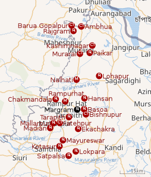 |
| Cities and towns in Rampurhat subdivision of Birbhum district M: municipal city/ town, CT: census town, R: rural/ urban centre. Owing to space constraints in the small map, the actual locations in a larger map may vary slightly |
Police station
Margarm police station has jurisdiction over Rampurhat II CD Block.[1][2]
CD block HQ
The headquarters of Rampurhat II CD block are located at Margram.[3]
Overview
The northern portion of Rampurhat subdivision (shown in the map alongside) is part of the Nalhati Plains, a sub-micro physiographic region, and the southern portion is part of the Brahmani-Mayurakshi Basin, another sub-micro physiographic region occupying the area between the Brahmani in the north and the Mayurakshi in the south. There is an occasional intrusion of Rajmahal Hills, from adjoining Santhal Parganas, towards the north-western part of the subdivision. On the western side is Santhal Parganas and the boder between West Bengal and Jharkhand can be seen in the map. Murshidabad district is on the eastern side. A small portion of the Padma River and the border with Bangladesh (thick line) can be seen in the north-eastern corner of the map.[4]96.62% of the population of Rampurhat subdivision live the rural areas and 3.38% of the population live in the urban areas.[5]
Note: The map alongside presents some of the notable locations in the area. All places marked in the map are linked in the larger full screen map.
Demographics
As per the 2011 Census of India, Margram had a total population of 30,055 of which 15,297 (51%) were males and 14,758 (49%) were females. Population below 6 years was 4,076. The total number of literates in Margram was 17,568 (67.62% of the population over 6 years).[6]
Transport
Margram is on the Rampurhat-Sherpur Road that links NH 14 at Rampurhat to SH 7 at Sherpur.[7]
Post Office
Margram has a delivery branch post office, with PIN 731202, under Baswa sub office and Rampurhat head office. Baswa sub office has the same PIN. Branch offices with the same PIN are situated at Barakartikchungri, Dakhalbati, Joykrishnapur, Kalua, Laha, Mallickpur and Ningha.[8]
Culture
Margram Bandhab Samiti Library, a government-sponsored library, was established in 1979. It has its own pucca building.[9]
Notable people
Muhammad Qudrat-i-Khuda, scientist, educationist and writer, was born in 1900 and spent his childhood at Margram. He and his associates patented 18 scientific inventions. He played an important role in popularising Bengali in scientific practices. He was the first Director of the East Regional Laboratories of the Pakistan Council of Scientific and Industrial Research in 1955. He was chairman of the National Education Commission of Bangladesh in 1972.[10]
Healthcare
Margram Primary Health Centre has 10 beds.[11]
References
- "District Statistical Handbook 2008, Birbhum" (PDF). Table 2.1. Bureau of Applied Economics and Statistics, Government of West Bengal. Retrieved 30 January 2018.
- "Birbhum Police". Police Stations. West Bengal Police. Retrieved 30 January 2018.
- "District Census Handbook: Birbhum, Series 20, Part XII B" (PDF). Map of Birbhum with CD Block HQs and Police Stations (on the fourth page). Directorate of Census Operations, West Bengal, 2011. Retrieved 1 February 2018.
- "District Census Handbook Birbhum, Census of India 2011, Series 20, Part XII A" (PDF). Page 15: Physiography. Directorate of Census Operations, West Bengal. Retrieved 30 January 2018.
- "2011 Census - Primary Census Abstract Data Tables". West Bengal – District-wise. Registrar General and Census Commissioner, India. Retrieved 30 January 2018.
- "2011 Census – Primary Census Abstract Data Tables". West Bengal – District-wise. Registrar General and Census Commissioner, India. Retrieved 1 February 2018.
- Google maps
- "Birbhum Postal Zip Code Finder by Post Office". pincodezip.in. Retrieved 1 February 2018.
- "List of Govt. Sponsored Libraries in the district of BIRBHUM" (PDF). Government of West Bengal. Retrieved 1 February 2018.
- "Qudrat-i-Khuda,_Muhammad". Banglapedia. Retrieved 5 February 2018.
- "Health & Family Welfare Department" (PDF). Health Statistics – Primary Health Centres. Government of West Bengal. Retrieved 26 January 2018.
Cities, towns and locations in Birbhum district, West Bengal | |||||||
|---|---|---|---|---|---|---|---|
| Cities, municipal and census towns |
| ||||||
| Locations other than cities and towns |
| ||||||
| See also |
| ||||||