Ilambazar
Ilambazar is a census town, with a police station, in Ilambazar CD block in Bolpur subdivision of Birbhum District in the Indian state of West Bengal. A traditional weaving and trading centre it serves as a gateway to Birbhum district.
Ilambazar | |
|---|---|
Census Town | |
 Ilambazar Location in West Bengal, India | |
| Coordinates: 23.63°N 87.53°E | |
| Country | |
| State | West Bengal |
| District | Birbhum |
| Area | |
| • Total | 1.8648 km2 (0.7200 sq mi) |
| Elevation | 54 m (177 ft) |
| Population (2011) | |
| • Total | 7,125 |
| • Density | 3,800/km2 (9,900/sq mi) |
| Languages | |
| • Official | Bengali, English |
| Time zone | UTC+5:30 (IST) |
| PIN | 731214 |
| Telephone/STD code | 91 3463 |
| Sex ratio | 843 ♂/♀ |
| Lok Sabha constituency | Bolpur |
| Vidhan Sabha constituency | Bolpur |
| Website | birbhum |
| CD Block | |
History
Ilambazar developed as a trade mart because of its location at the junction of thoroughfares and the river front. It also had the advantage of being near to weaving centres.[1] The English assumed the direct administration of the district in 1786 and the British East India Company had a factory at Ilambazar. At that time the French East India Company also made a foray in the Ilambazar area. It helped in the weavers securing higher prices.[2]
Birbhum was one of the worst sufferers of the Great Bengal famine of 1770. Many hundreds of villages were entirely depopulated and in the towns not a fourth of the population survived.[3] In the late 18th century, Birbhum and surrounding areas were affected by famines followed by a peasants’ insurrection. Although the insurrection was against zamindars and the government, trade marts were also plundered. In June 1789, Ilambazar, the chief manufacturing and trade centre in the area was sacked in open dylight.[4] Ilambazar survived the sack of 1789 and re-emerged as a busy manufacturing and trade centre since the opening of the 19th century. At the time of Shewill's survey operations it contained a population of 2,235 souls.[5]
Cotton goods were not the only items of trade. In the mid 19th century, John Erskine of Ilambazar was one of the leading sugar manufacturers and exporters in the area.[6] The Erskine family also had indigo factories.[7] Ilambazar was once an area for indigo cultivation, traces of which can still be found.[8]
Geography
 |
| Cities and towns in Bolpur subdivision of Birbhum district M: municipal city/ town, CT: census town, R: rural/ urban centre, U: University. Owing to space constraints in the small map, the actual locations in a larger map may vary slightly |
Location
Ilambazar is located at 23.63°N 87.53°E. It has an average elevation of 54 m (177 ft).[9]
Note: The map alongside presents some of the notable locations in the area. All places marked in the map are linked in the larger full screen map.
Ilambazar is located on the northern bank of Ajay River. It is on the four-lane Panagarh–Morgram Highway. The highway has been completed at a cost of $150-million.[10] A road connects to Bolpur/Santiniketan and ( Suri - Kirnahar - Katwa ) Road
Most of the forests in Birbhum district are on laterite soil but the Choupahari sal forests in the Ilambazar area (area 13.9 km²) are on alluvial soil.[11]
The forests around Ilambazar was on the verge of extinction in the nineties of the previous century but it has got back much of its flora and fauna. The villagers, living in 32 villages located inside the forest, have realised that they can make a living by selling plates (thalis) made of sal leaves and mushrooms (locally called toshor ghuti) both abundantly available in the forest. The forest department formed 12 ‘Bonosamrakshan committees’ (forest preservation committees) comprising the villagers and made them understand how their survival was linked with that of the forest.[12]
CD block HQ
The headquarters of Ilambazar CD block are located at Ilambazar.[15]
Demographics
As per the 2011 Census of India, Ilambazar had a total population of 7,125 of which 3,632 (51%) were males and 3,493 (49%) were females. Population below 6 years was 443. The total number of literates in Ilambazar was 5,246 (82.67% of the population over 6 years).[16]
Infrastructure
As per the District Census Handbook 2011, Ilambazar covered an area of 1.8648 km2. There is a railway station at Bolpur 18 km away. Buses are available in the town. It has 70 km roads and both open and closed drains. The major source of protected water supply is from bore well pumping and over head tank. There are 1,654 domestic electric connections and 100 road light points. Amongst the medical facilities it has 2 hospitals with 280 beds, 4 dispensaries/ health centres and 3 maternity and child welfare centres. Amongst the educational facilities it has are 2 primary schools, 1 secondary school and 1 senior secondary school. Amongst the social, recreational and cultural facilities there is 1 cinema theatre, 1 auditorium/ community hall and 1 public library. It has the branches of 3 nationalised banks, 1 cooperative bank, 1 agricultural credit society and 2 non-agricultural credit societies. Amongst the commodities it produced were rice milling products, bamboo products and kantha stitch products.[17]
Education
ILLAMBAZAR JATIYA YUVA COMPUTER SHAKSHARTA MISSION - Illambazar JYCSM was established at Illambazar in early 2018. It is recognized by Govt. Of India and also Govt of West Bengal, it offers Certificate, Diploma and Advance Diploma Courses. This Computer Training Centre is one of the best centres in Illambazar[18]
Kabi Joydeb Mahavidyalaya was established at Ilambazar in 2007. Affiliated to the University of Burdwan, it offers honours courses in Bengali and English.[19][20]
Culture
Temples
The Gouranga temple at Ilambazar, and the Shiva temple at Ghurisha are amongst the state protected temples in the area.[21] Rameswara Shiva temple is one of the three temples at Ilambazar with exquisite terracotta work.[22]
During the late 1940s Ilambazar terracotta temples were photo-documented by artist Mukul Dey of Santiniketan.
David J. McCutchion mentions several temples in the Ilambazar area:
(1) the Shiva temple at Ilambazar as a standard (small) 19th century ‘Birbhum-Bradhaman’ type brick built rekha deul with rich terracotta façade,
(2) the four Shiva temples at Uchkaron as standard (small) char chalas, built in 1769, with rich terracotta facades,
(3) the 19th century Lakshmi-Janardana temple at Ilambazar, as a standard West Bengal type pancharatna with ridged rekha turrets and porch on triple archway,
(4) the 17-18th century Radha Vinode temple at Jaydev Kenduli as a low storied West Bengal navaratna with ridged turrets,
(5) the 19th century Lakshmi Janardana temple at Ghurisha is a straight corniced navaratna with very large upper tower and tiny clustering corner towers with rich terracotta, and
(6) the 19th century temple in the market place at Ilambazar as an octagonal ridged rekha with rich terracotta on all sides.[23]
According to Binoy Ghosh, there are three temples at Ilambazar with beautiful terracotta designs: the hexagonal temple at hattala, the Shiva temple in the village and the pancharatna Narayan temple. There are pictures of British people amongst the terracotta desigs. Ghurisa, about 4 miles west of Ilambazar, has rich temple traditions but many of them are in a state of decay. There is a char chala temple, which was constructed in 1555. It is said that there was a golden idol of Rama in the temple, but the Bargis took it away around 1742-48. Moukhira, a village about 3 miles south of Ilambazar, has many early 19th century temples. Benoy Ghosh notes that the portrayal of Europeans in the temple carvings in Birbhum district are more than in other places, perhaps because of the activities of the early European merchants in the area.[24]
Temple picture gallery
 Raghunathji Temple with Shiva deity at Ghurisha
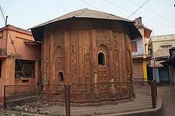 Gouranga temple at Ilambazar
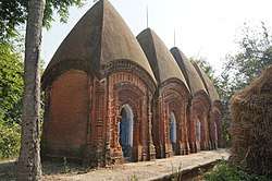 Four Shiva temples at Uchkaron
Craft
John Erskine and John Cheap took an important part in the development of the shellac industry. Erskine constructed a large shellac and lac dye factory at Ilambazar and as Cheap retired from the field, virtually monopolized it. The lac was collected from the forests and lac dye and shellac manufactured in the factory at Ilambazar. Lac artisans, locally called nuris, worked out a variety of lacquered items namely, cups, inkpots, bracelets and toys ‘of excellent design and craftsmanship’. Some of the ornamental items were sent to the Great Paris Exhibition of 1855. However, Sherwill noted that ornamental items were manufactured at Ilambazar by only two men.[25]
Healthcare
Ilambazar Rural Hospital at Ilambazar has 30 beds.[26]
References
- Gupta, Dr. Ranjan Kumar, The Economic Life of a Bengal District: Birbhum 1770 – 1857, p. 14, The University of Burdwan, 1984.
- Gupta, Dr. Ranjan Kumar, p. 152
- Gupta, Dr. Ranjan Kumar, p. 257
- Gupta, Dr. Ranjan Kumar, pp. 44, 47
- Gupta, Dr. Ranjan Kumar, p. 260
- Gupta, Dr. Ranjan Kumar, p. 188
- Gupta, Dr. Ranjan Kumar, p. 191
- Sarkar, Joydeep, Paryatan Boichitre Birbhum Jela, Paschim Banga, Birbhum Special Issue, February 2006, (in Bengali), p. 199, Information & Cultural Department, Government of West Bengal.
- "Ilam Bazar, India Page". West Bengal. Falling Rain Genomics. Retrieved 19 August 2008.
- "$210 m ADB loan for north-south corridor". The Statesman, 28 May 2001. Retrieved 17 September 2007.
- Ghosh, Kanailal, Birbhumer Bon Udbhidjo O Banyapran, Paschim Banga, Birbhum Special Issue, February 2006, (in Bengali), p. 193, Information & Cultural Department, Government of West Bengal.
- "Collective effort to restore greenery". The Statesman, 9 October 2002. Retrieved 17 September 2007. Illambazar Helpful Boy Arozkhadim From- IIllambazar
- "District Statistical Handbook 2008, Birbhum" (PDF). Table 2.1. Bureau of Applied Economics and Statistics, Government of West Bengal. Retrieved 30 January 2018.
- "Birbhum Police". Police Stations. West Bengal Police. Retrieved 30 January 2018.
- "District Census Handbook: Birbhum, Series 20, Part XII B" (PDF). Map of Birbhum with CD Block HQs and Police Stations (on the fourth page). Directorate of Census Operations, West Bengal, 2011. Retrieved 1 February 2018.
- "2011 Census – Primary Census Abstract Data Tables". West Bengal – District-wise. Registrar General and Census Commissioner, India. Retrieved 1 February 2018.
- "District Census Handbook Birbhum, Census of India 2011, Series 20, Part XII A" (PDF). Section II Town Directory, Pages 1025- 1033. Directorate of Census Operations V, West Bengal. Retrieved 16 July 2019.
- "Illambazar Jatiya Yuva Computer Shaksharta Mission". Computer Training Centre. Retrieved 21 February 2020.
- "Kabi Joydeb Mahavidyalaya". KJM. Retrieved 9 February 2018.
- "Kabi Joydeb Mahavidyalaya". College Admission. Retrieved 9 February 2018.
- "List of State Protected Monuments & Sites". District Birbhum. Deptt of Information and Culture, Government of West Bengal. Retrieved 24 August 2007.
- "Indian Heritage". Rameswara Shiva temple. indianheritages.blogspot.com. Retrieved 17 September 2007.
- McCutchion, David J., Late Mediaeval Temples of Bengal, first published 1972, reprinted 2017, pages 23, 30, 47, 53, 54, 59 . The Asiatic Society, Kolkata, ISBN 978-93-81574-65-2
- Ghosh, Binoy, Paschim Banger Sanskriti, (in Bengali), part I, 1976 edition, pages 267-271, Prakash Bhaban, Kolkata
- Gupta, Dr. Ranjan Kumar, p. 196
- "Health & Family Welfare Department" (PDF). Health Statistics – Rural Hospitals. Government of West Bengal. Retrieved 26 January 2018.
Cities, towns and locations in Birbhum district, West Bengal | |||||||
|---|---|---|---|---|---|---|---|
| Cities, municipal and census towns |
| ||||||
| Locations other than cities and towns |
| ||||||
| See also |
| ||||||