List of lighthouses in Ireland
This is a list of lighthouses in Ireland. The Commissioners of Irish Lights are responsible for the majority of marine navigation aids around the island though a small number are maintained by local harbour authorities. The main list identifies those lighthouses in a clockwise direction starting with Crookhaven lighthouse, County Cork.[1][2][3][4][5]
Maintained by Commissioners of Irish Lights
| Name | Image | Location Coordinates |
County | Water body | Year built | Tower height | Focal height | Range |
|---|---|---|---|---|---|---|---|---|
| Crookhaven Lighthouse |  | Crookhaven 51.477°N 9.705°W | Cork | Celtic Sea | 1843 | 14 m (46 ft) | 20 m (66 ft) | 13 nmi (24 km) |
| Mizen Head Lighthouse |  | Mizen Head 51.45°N 9.82°W | Cork | Celtic Sea | 1959 | 4 m (13 ft) | 55 m (180 ft) | 15 nmi (28 km) |
| Roancarrigmore Lighthouse |  | Roancarrigmore Island 51.653°N 9.747°W | Cork | Bantry Bay | 1847 | 7 m (23 ft) | 18 m (59 ft) | 11 nmi (20 km) |
| Castletownbere Light |  | Castletownbere 51.647°N 9.905°W | Cork | Bantry Bay | 1965 | 5 m (16 ft) | 7 m (23 ft) | 15 nmi (28 km) |
| Ardnakinna Point Lighthouse | 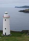 | Bere Island 51.618°N 9.918°W | Cork | Bantry Bay | 1850/1965 | 20 m (66 ft) | 62 m (203 ft) | 17 nmi (31 km) |
| Sheep's Head Lighthouse |  | Sheep's Head 51.543°N 9.849°W | Cork | Bantry Bay | 1968 | 7 m (23 ft) | 83 m (272 ft) | 18 nmi (33 km) |
| Bull Rock Lighthouse | %2C_The_Bull_-_geograph.org.uk_-_284005.jpg) | Bull Rock 51.592°N 10.301°W | Cork | North Atlantic | 1889 | 15 m (49 ft) | 91 m (299 ft) | 18 nmi (33 km) |
| Skelligs Lighthouse | _(2).jpg) | Skellig Michael 51.768°N 10.542°W | Kerry | North Atlantic | 1826/1967 | 12 m (39 ft) | 53 m (174 ft) | 12 nmi (22 km) |
| Valentia Light | Valentia Island 51.925°N 10.307°W | Kerry | North Atlantic | 1913 | 6 m (20 ft) | 25 m (82 ft) | 11 nmi (20 km) | |
| Cromwell Point Lighthouse | 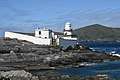 | Valentia Island 51.934°N 10.321°W | Kerry | North Atlantic | 1841 | 15 m (49 ft) | 16 m (52 ft) | 17 nmi (31 km) |
| Inishtearaght Lighthouse | 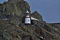 | Tearaght Island 52.076°N 10.661°W | Kerry | North Atlantic | 1870 | 17 m (56 ft) | 84 m (276 ft) | 19 nmi (35 km) |
| Little Samphire Island Lighthouse |  | Fenit 52.271°N 9.882°W | Kerry | Tralee Bay | 1854 | 12 m (39 ft) | 17 m (56 ft) | 14 nmi (26 km) |
| Inis Cathaig Lighthouse | 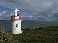 | Scattery Island 52.606°N 9.518°W | Clare | Shannon | 1872 | 12 m (39 ft) | 15 m (49 ft) | 10 nmi (19 km) |
| Corlis Point rear (Querrin Quay) leading light |  | Carrigaholt 52.628°N 9.589°W | Clare | Shannon | 1998 | 25 m (82 ft) | 27 m (89 ft) | 10 nmi (19 km) |
| Corlis Point front leading light | Carrigaholt 52.618°N 9.606°W | Clare | Shannon | 1998 | 4 m (13 ft) | 9 m (30 ft) | 10 nmi (19 km) | |
| Loophead Lighthouse |  | Loop Head 52.561°N 9.932°W | Clare | North Atlantic | 1854 | 23 m (75 ft) | 84 m (276 ft) | 23 nmi (43 km) |
| Inisheer Lighthouse | 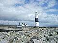 | Inisheer 53.047°N 9.527°W | Galway | North Atlantic | 1857 | 34 m (112 ft) | 34 m (112 ft) | 20 nmi (37 km) |
| Black Head Lighthouse, County Clare | 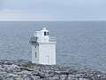 | Fanore 53.154°N 9.264°W | Clare | Galway Bay | 1936 | 8 m (26 ft) | 20 m (66 ft) | 11 nmi (20 km) |
| Cashla Bay Lighthouse |  | Casla 53.264°N 9.566°W | Galway | Galway Bay | 1984 | 4 m (13 ft) | 6 m (20 ft) | 8 nmi (15 km) |
| Straw Island Lighthouse |  | Aran Islands 53.118°N 9.631°W | Galway | North Atlantic | 1878 | 11 m (36 ft) | 11 m (36 ft) | 15 nmi (28 km) |
| Eeragh Lighthouse | 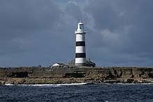 | Aran Islands 53.148°N 9.857°W | Galway | North Atlantic | 1857 | 31 m (102 ft) | 35 m (115 ft) | 18 nmi (33 km) |
| Slyne Head Lighthouse | 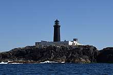 | Slyne Head lighthouse 53.4°N 10.234°W | Galway | North Atlantic | 1836 | 24 m (79 ft) | 35 m (115 ft) | 19 nmi (35 km) |
| Inishgort Lighthouse |  | Clew Bay 53.827°N 9.671°W | Mayo | Clew Bay | 1827 | 8 m (26 ft) | 11 m (36 ft) | 10 nmi (19 km) |
| Achillbeg Lighthouse | 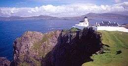 | Achillbeg 53.858°N 9.947°W | Mayo | Clew Bay | 1965 | 9 m (30 ft) | 56 m (184 ft) | 18 nmi (33 km) |
| Blacksod Lighthouse | .jpg) | Blacksod Bay 54.099°N 10.06°W | Mayo | North Atlantic | 1864 | 12 m (39 ft) | 13 m (43 ft) | 12 nmi (22 km) |
| Blackrock Mayo Lighthouse | 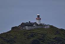 | Blacksod Bay 54.068°N 10.321°W | Mayo | North Atlantic | 1864 | 15 m (49 ft) | 86 m (282 ft) | 20 nmi (37 km) |
| Eagle Island lighthouse | 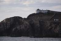 | Eagle Island 54.284°N 10.093°W | Mayo | North Atlantic | 1835 | 11 m (36 ft) | 67 m (220 ft) | 18 nmi (33 km) |
| Broadhaven Lighthouse | 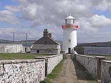 | Broadhaven Bay 54.268°N 9.889°W | Mayo | North Atlantic | 1848 | 15 m (49 ft) | 27 m (89 ft) | 17 nmi (31 km) |
| Oyster Island Lighthouse | 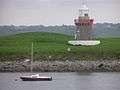 | Rosses Point 54.302°N 8.571°W | Sligo | Sligo Bay | 1837/1893 | 12 m (39 ft) | 13 m (43 ft) | 7 nmi (13 km) |
| Metal Man Sligo Lighthouse | 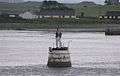 | Rosses Point 54.304°N 8.576°W | Sligo | Sligo Bay | 1821 | 5 m (16 ft) | 3 m (10 ft) | 7 nmi (13 km) |
| Lower Rosses Lighthouse | Rosses Point 54.329°N 8.573°W | Sligo | Sligo Bay | 1908 | 8 m (26 ft) | 8 m (26 ft) | 13 nmi (24 km) | |
| Blackrock Sligo Lighthouse | 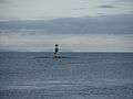 | Sligo Bay 54.308°N 8.618°W | Sligo | Sligo Bay | 1835 | 25 m (82 ft) | 24 m (79 ft) | 10 nmi (19 km) |
| Rotten Island lighthouse |  | Rotten Island 54.615°N 8.441°W | Donegal | Donegal Bay | 1838 | 14 m (46 ft) | 20 m (66 ft) | 15 nmi (28 km) |
| St John's Point Lighthouse, County Donegal | 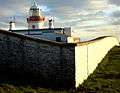 | Dunkineely 54.569°N 8.461°W | Donegal | Donegal Bay | 1831 | 14 m (46 ft) | 30 m (98 ft) | 14 nmi (26 km) |
| Rathlin O'Birne Lighthouse | 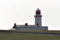 | Glencolmcille 54.664°N 8.833°W | Donegal | North Atlantic | 1856 | 20 m (66 ft) | 35 m (115 ft) | 12 nmi (22 km) |
| Ballagh Rocks Lighthouse | 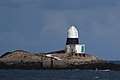 | Arranmore 54.999°N 8.481°W | Donegal | North Atlantic | 1982 | 10 m (33 ft) | 13 m (43 ft) | 5 nmi (9 km) |
| Arranmore Lighthouse |  | Arranmore 55.015°N 8.561°W | Donegal | North Atlantic | 1798/1865 | 23 m (75 ft) | 71 m (233 ft) | 27 nmi (50 km) |
| Tory Island Lighthouse | 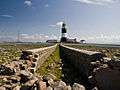 | Tory Island 55.273°N 8.249°W | Donegal | North Atlantic | 1832 | 27 m (89 ft) | 40 m (131 ft) | 18 nmi (33 km) |
| Buncrana Light | 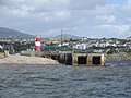 | Buncrana 55.127°N 7.465°W | Donegal | Lough Swilly | 1876/2009 | 6 m (20 ft) | 11 m (36 ft) | 13 nmi (24 km) |
| Dunree Lighthouse | 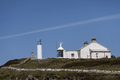 | Dunree 55.198°N 7.554°W | Donegal | Lough Swilly | 1876 | 6 m (20 ft) | 46 m (151 ft) | 12 nmi (22 km) |
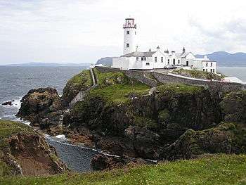
| Fanad Head Lighthouse | | Fanad 55.276°N 7.632°W | Donegal | North Atlantic | 1817/1886 | 22 m (72 ft) | 39 m (128 ft) | 18 nmi (33 km) |
| Inishtrahull Lighthouse | 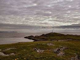 | Inishtrahull Island 55.431°N 7.244°W | Donegal | North Atlantic | 1812/1958 | 23 m (75 ft) | 59 m (194 ft) | 19 nmi (35 km) |
| Inishowen Lighthouse | 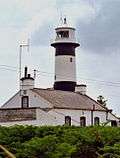 | Inishowen 55.226°N 6.929°W | Donegal | North Atlantic | 1837 | 23 m (75 ft) | 29 m (95 ft) | 18 nmi (33 km) |
| Rathlin West Lighthouse | 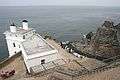 | Rathlin Island 55.301°N 6.281°W | Antrim | North Channel | 1917 | 18 m (59 ft) | 62 m (203 ft) | 22 nmi (41 km) |
| Rathlin East (Altacarry Head) Lighthouse | 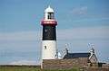 | Rathlin Island 55.302°N 6.172°W | Antrim | North Channel | 1856 | 27 m (89 ft) | 74 m (243 ft) | 26 nmi (48 km) |
| Rue Point Lighthouse | 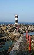 | Rathlin Island 55.259°N 6.191°W | Antrim | North Channel | 1915/1921 | 11 m (36 ft) | 16 m (52 ft) | 14 nmi (26 km) |
| Maidens Lighthouse | .jpg) | The Maidens 54.929°N 5.728°W | Antrim | North Channel | 1829 | 23 m (75 ft) | 29 m (95 ft) | 23 nmi (43 km) |
| Chaine Memorial | 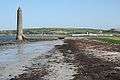 | Larne 54.855°N 5.798°W | Antrim | North Channel | 1899 | 23 m (75 ft) | 23 m (75 ft) | 16 nmi (30 km) |
| Blackhead Lighthouse, County Antrim | 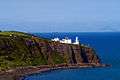 | Whitehead 54.767°N 5.689°W | Antrim | North Channel | 1902 | 16 m (52 ft) | 45 m (148 ft) | 27 nmi (50 km) |
| Mew Island Lighthouse | 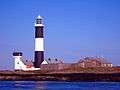 | Mew Island 54.699°N 5.514°W | Down | North Channel | 1884 | 37 m (121 ft) | 37 m (121 ft) | 24 nmi (44 km) |
| Donaghadee Lighthouse | 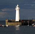 | Donaghadee 54.645°N 5.531°W | Down | North Channel | 1836 | 16 m (52 ft) | 17 m (56 ft) | 17 nmi (31 km) |
| Angus Rock Lighthouse | 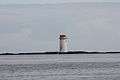 | Strangford Lough 54.331°N 5.525°W | Down | Strangford Lough | 1983 | 13 m (43 ft) | 15 m (49 ft) | 5 nmi (9 km) |
| St John's Point Lighthouse, County Down | 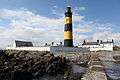 | Killough 54.227°N 5.66°W | Down | Irish Sea | 1844/1893 | 39 m (128 ft) | 37 m (121 ft) | 25 nmi (46 km) |
| Green Island Leading Light |  | Carlingford Lough 54.033°N 6.096°W | Down | Carlingford Lough | 1873 | 14 m (46 ft) | 13 m (43 ft) | 11 nmi (20 km) |
| Vidal Bank Leading Light |  | Carlingford Lough 54.03°N 6.091°W | Down | Carlingford Lough | 1873 | 8 m (26 ft) | 7 m (23 ft) | 11 nmi (20 km) |
| Haulbowline Lighthouse | 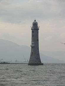 | Carlingford Lough 54.02°N 6.079°W | Down | Irish Sea | 1824 | 34 m (112 ft) | 32 m (105 ft) | 10 nmi (19 km) |
| Dundalk Lighthouse |  | Dundalk 53.976°N 6.295°W | Louth | Irish Sea | 1855 | 10 m (33 ft) | 10 m (33 ft) | 10 nmi (19 km) |
| Rockabill Lighthouse |  | Rockabill 53.597°N 6.005°W | Dublin | Irish Sea | 1860 | 32 m (105 ft) | 45 m (148 ft) | 18 nmi (33 km) |
| Baily Lighthouse | 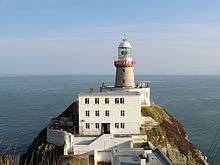 | Howth Head 53.362°N 6.053°W | Dublin | Dublin Bay | 1814 | 13 m (43 ft) | 41 m (135 ft) | 18 nmi (33 km) |
| Dún Laoghaire West Lighthouse | 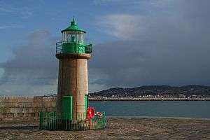 | Dún Laoghaire 53.303°N 6.131°W | Dublin | Dublin Bay | 1852 | 9 m (30 ft) | 11 m (36 ft) | 7 nmi (13 km) |
| Dún Laoghaire East Lighthouse | 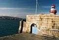 | Dún Laoghaire 53.303°N 6.127°W | Dublin | Dublin Bay | 1847 | 12 m (39 ft) | 16 m (52 ft) | 17 nmi (31 km) |
| Muglins Lighthouse | _(3).jpg) | Dalkey Island 53.275°N 6.076°W | Dublin | Dublin Bay | 1906 | 9 m (30 ft) | 14 m (46 ft) | 11 nmi (20 km) |
| Kish Lighthouse |  | Kish Bank 53.311°N 5.926°W | Dublin | Dublin Bay | 1965 | 31 m (102 ft) | 29 m (95 ft) | 22 nmi (41 km) |
| Wicklow Head Lighthouse |  | Wicklow Head 52.966°N 5.998°W | Wicklow | St George's Channel | 1781/1818 | 14 m (46 ft) | 37 m (121 ft) | 23 nmi (43 km) |
| Tuskar Rock Lighthouse | 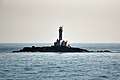 | Tuskar Rock 52.203°N 6.207°W | Wexford | St George's Channel | 1815 | 34 m (112 ft) | 33 m (108 ft) | 24 nmi (44 km) |
| Dunmore East Lighthouse | 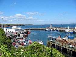 | Dunmore East 52.149°N 6.99°W | Waterford | Celtic Sea | 1825 | 16 m (52 ft) | 13 m (43 ft) | 17 nmi (31 km) |
| Hook Lighthouse | 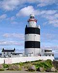 | Hook Head 52.124°N 6.93°W | Wexford | Celtic Sea | 1172 | 35 m (115 ft) | 46 m (151 ft) | 23 nmi (43 km) |
| Ballinacourty Point Lighthouse |  | Dungarvan 52.078°N 7.553°W | Waterford | Celtic Sea | 1858 | 13 m (43 ft) | 16 m (52 ft) | 10 nmi (19 km) |
| Mine Head Lighthouse | 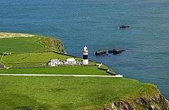 | Mine Head 51.993°N 7.587°W | Waterford | Celtic Sea | 1851 | 21 m (69 ft) | 87 m (285 ft) | 12 nmi (22 km) |
| Youghal Lighthouse | 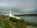 | Youghal 51.943°N 7.842°W | Cork | Celtic Sea | 1852 | 15 m (49 ft) | 24 m (79 ft) | 17 nmi (31 km) |
| Ballycotton Lighthouse | 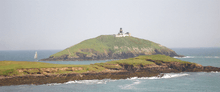 | Ballycotton 51.825°N 7.986°W | Cork | Celtic Sea | 1851 | 15 m (49 ft) | 59 m (194 ft) | 21 nmi (39 km) |
| Roche's Point Lighthouse |  | Cork Harbour 51.793°N 8.255°W | Cork | Cork Harbour | 1817/1835 | 15 m (49 ft) | 30 m (98 ft) | 20 nmi (37 km) |
| Charlesfort Lighthouse | 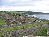 | Charlesfort 51.696°N 8.5°W | Cork | Kinsale Harbour | Unknown | 5 m (16 ft) | 18 m (59 ft) | 9 nmi (17 km) |
| Old Head of Kinsale Lighthouse | 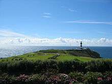 | Old Head of Kinsale 51.605°N 8.534°W | Cork | Celtic Sea | 1665/1853 | 30 m (98 ft) | 72 m (236 ft) | 20 nmi (37 km) |
| Galley Head Lighthouse | 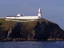 | Galley Head 51.53°N 8.954°W | Cork | Celtic Sea | 1878 | 21 m (69 ft) | 53 m (174 ft) | 23 nmi (43 km) |
| Copper Point Lighthouse | 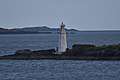 | Long Island 51.504°N 9.534°W | Cork | Celtic Sea | 1864 | 15 m (49 ft) | 16 m (52 ft) | 8 nmi (15 km) |
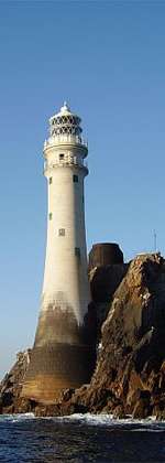
| Fastnet Lighthouse | 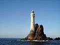 | Fastnet Rock 51.389°N 9.603°W | Cork | Celtic Sea | 1854/1904 | 54 m (177 ft) | 49 m (161 ft) | 27 nmi (50 km) |
Maintained by other Irish marine authorities
A smaller number of active lighthouses are operated by other authorities, primarily the port and harbour companies located around the Irish coast.[1][2][3][4]
| Name | Image | Location Coordinates |
County | Waterbody | Built | Tower Height | Focal Height | Operated by |
|---|---|---|---|---|---|---|---|---|
| Aleria | 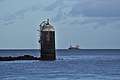 | Drogheda 53.7225°N 6.2388°W | Louth | Irish Sea | 1936 | 10 m (33 ft) | 11 m (36 ft) | Drogheda Port Company |
| Ardglass Pier | .JPG) | Ardglass 54.2610°N 5.6027°W | Down | Ardglass Harbour | 1885 | 9.5 m (31 ft) | 10 m (33 ft) | Northern Ireland Fishery Harbour Authority |
| Balbriggan | 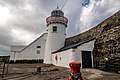 | Balbriggan 53.6129°N 6.1787°W | Fingal | Irish Sea | 1769 | 11 m (36 ft) | 12 m (39 ft) | Dublin Port Company |
| Ballynagard | .jpg) | River Foyle 55.0380°N 7.2736°W | Londonderry | River Foyle | Unknown | 7 m (23 ft) | 6 m (20 ft) | Londonderry Port |
| Barrack Point |  | Sherkin Island 51.4728°N 9.3947°W | Cork | Baltimore Harbour | 1885 | 8 m (26 ft) | 40 m (131 ft) | Cork County Council |
| Beeves Rock | Shannon Estuary 52.6502°N 9.0225°W | Clare | Shannon Estuary | 1855 | 18 m (59 ft) | 12 m (39 ft) | Shannon Foynes Port Company | |
| Dingle Harbour | 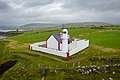 | Dingle 52.1216°N 10.2582°W | Kerry | Dingle Harbour | 1885 | 7 m (23 ft) | 20 m (66 ft) | Dingle Fishery Harbour Centre |
| Duncannon Fort | Duncannon Fort 52.2205°N 6.9374°W | Wexford | Waterford Harbour | Unknown | 7.5 m (25 ft) | 13 m (43 ft) | Port of Waterford Company | |
| Duncannon North |  | Duncannon 52.2292°N 6.9369°W | Wexford | Waterford Harbour | 1838 | 10.5 m (34 ft) | 39 m (128 ft) | Port of Waterford Company |
| Galway Harbour | Galway Harbour 53.2554°N 9.0319°W | Galway | Galway Bay | 1977 | 9 m (30 ft) | 9 m (30 ft) | Galway Harbour Company | |
| Howth Harbour |  | Howth 53.3941°N 6.0669°W | Fingal | Irish Sea | 1982 | 10 m (33 ft) | 13 m (43 ft) | Dublin Port Company |
| Moville | Moville 55.1831°N 7.0354°W | Donegal | Lough Foyle | 1882 | 13.5 m (44 ft) | 11 m (36 ft) | Londonderry Port | |
| North Bank | .jpg) | Dublin Port 53.3448°N 6.1765°W | Fingal | River Liffey | 1882 | 11 m (36 ft) | 10 m (33 ft) | Dublin Port Company |
| North Bull | 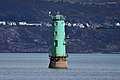 | North Bull Island 53.3449°N 6.1497°W | Fingal | Dublin Bay | 1880 | 15 m (49 ft) | 15 m (49 ft) | Dublin Port Company |
| North Wall Quay |  | Dublin Port 53.3457°N 6.2165°W | Fingal | River Liffey | 1904 | 12 m (39 ft) | 12 m (39 ft) | Dublin Port Company |
| Poolbeg | _(33020734955).jpg) | Poolbeg 53.3421°N 6.1517°W | Fingal | Dublin Bay | 1820 | 20 m (66 ft) | 20 m (66 ft) | Dublin Port Company |
| Rosslare Harbour | 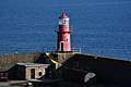 | Rosslare Europort 52.2571°N 6.3381°W | Wexford | St Georges Channel | 1906 | 7.5 m (25 ft) | 15 m (49 ft) | Rosslare Europort |
| Spillane's Tower | Limerick 52.6558°N 8.6615°W | Limerick | River Shannon | 1885 | 11 m (36 ft) | 11 m (36 ft) | Shannon Foynes Port Company | |
| Spit Bank |  | Cobh 51.8453°N 8.2739°W | Cork | Cork Harbour | 1853 | 10.5 m (34 ft) | 10 m (33 ft) | Port of Cork Company |
| Tarbert Island | 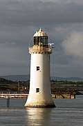 | Tarbet 52.5920°N 9.3636°W | Kerry | River Shannon | 1834 | 22.5 m (74 ft) | 18 m (59 ft) | Shannon Foynes Port Company |
| Warren Point |  | Greencastle 55.2097°N 6.9519°W | Donegal | Lough Foyle | 1861 | 8 m (26 ft) | 9 m (30 ft) | Londonderry Port |
| Wicklow East Pier |  | Wicklow 52.9832°N 6.0344°W | Wicklow | Irish Sea | 1884 | 7 m (23 ft) | 11 m (36 ft) | Wicklow Port Company |
Inactive
Improvements and changes to the aids to navigation around the Irish coast, has meant that there are a number of lighthouses that have been decommissioned. This list includes those where the tower or structure is still in existence. Some of these have been reused, such as Ferris Point which is now a vessel control tower. Clare Island was turned into a guest house, and the older Wicklow Head tower was refurbished by the Irish Landmark Trust as a holiday let.[1][2][3][4]
| Name | Image | Location Coordinates |
County | Waterbody | Built | Inactive since |
Notes |
|---|---|---|---|---|---|---|---|
| Ballycurrin | 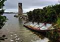 | Headford 53.4851°N 9.2130°W | Mayo | Lough Corrib | 1847 | Unknown | Unusual lakeshore light with external staircase.[4] |
| Blackrock Castle | .jpg) | Cork 51.9000°N 8.4025°W | Cork | Cork Harbour | 1582 | 1903 | A light was shown from a window in the highest tower.[3] |
| Calf Rock | .jpg) | Dursey Island 51.5850°N 10.2763°W | Cork | North Atlantic | 1866 | 1881 | The tower was badly damaged by a storm in 1881.[3] |
| Cape Clear | Cape Clear Island 51.4345°N 9.4846°W | Cork | Celtic Sea | 1818 | 1854 | Deactivated after the original Fastnet lighthouse was completed.[3] | |
| Clare Island | .jpg) | Clare Island 53.8275°N 9.9834°W | Mayo | Clew Bay | 1818 | 1965 | Refurbished as a guest house.[4] |
| Culmore Point | .jpg) | Culmore 55.0464°N 7.2541°W | Londonderry | River Foyle | 1920s | 2012 | White and green tower next to Culmore Fort. Replaced by a post light.[1] |
| Drogheda East | 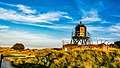 | Mornington 53.7192°N 6.2476°W | Meath | River Boyne | 1880s | 2007 | One of three lights constructed to aid navigation along the Boyne and into the harbour at Drogheda.[2] |
| Drogheda North | Mornington 53.7241°N 6.2544°W | Meath | River Boyne | 1880s | 2000 | One of three lights constructed to aid navigation along the Boyne and into the harbour at Drogheda.[2] | |
| Drogheda West | Mornington 53.7189°N 6.2489°W | Meath | River Boyne | 1880s | 2000 | One of three lights constructed to aid navigation along the Boyne and into the harbour at Drogheda.[2] | |
| Ferris Point |  | Larne 54.8514°N 5.7900°W | Antrim | Larne Lough | Unknown | 1994 | Now houses the control room for the Port of Larne. [1] |
| Greenore | 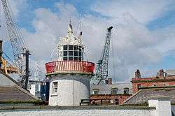 | Greenore 54.0337°N 6.1322°W | Louth | Carlingford Lough | 1830 | 1986 | Located on Carlingford Lough next to Greenore Port.[2] |
| Howth Harbour |  | Howth 53.3933°N 6.0668°W | Fingal | Irish Sea | 1818 | 1982 | Replaced by modern light nearby.[2] |
| Inishmore | 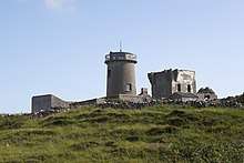 | Inishmore 53.1274°N 9.7022°W | Galway | Galway Bay | 1818 | 1857 | The first lighthouse in the Aran Islands, built on the highest point of Inishmore.[4] |
| Inishowen East | 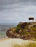 | Inishowen 55.2266°N 6.9271°W | Donegal | North Channel | 1837 | 1961 | Squat tower separate from the active West Inishowen Lighthouse.[4] |
| Kilcredaun Head | 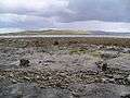 | Carrigaholt 52.5798°N 9.7097°W | Clare | Shannon Estuary | 1824 | 2011 | Positioned on a headland on the northern shore of the estuary.[3] |
| Mutton Island | _(26324379932).jpg) | Mutton Island 53.2541°N 9.0535°W | Galway | Galway Bay | 1817 | 1977 | Replaced by the Galway Harbour lighthouse. Restored between 2005 and 2011.[4] |
| Skelling Michael (High) | Skelling Michael 51.7702°N 10.5438°W | Kerry | North Atlantic | 1826 | 1870 | Built on a high ledge on the western flank of Skelling Michael.[3] | |
| South Rock (Kilwarlin) | Kearney 54.4030°N 5.3833°W | Down | North Channel | 1797 | 1877 | Considered to be the "oldest surviving waveswept lighthouse in Ireland". [1] | |
| West Maidens | 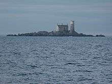 | The Maidens 54.9957°N 5.7136°W | Antrim | North Channel | 1829 | 1903 | Built at the same time as the East Maidens light.[1] |
| Wicklow Head High (1781) |  | Wicklow Head 52.9652°N 6.0025°W | Wicklow | St George's Channel | 1781 | 1818 | Octagonal tower, renovated as a holiday let by the Irish Landmark Trust in 1996.[2] |
| Wicklow Head High (1818) |  | Wicklow Head 52.9655°N 6.0005°W | Wicklow | St George's Channel | 1818 | 1865 | Round tower, built to complement the currently active low level light.[2] |
References
- Rowlett, Russ. "Lighthouses of Northern Ireland". The Lighthouse Directory. University of North Carolina at Chapel Hill. Retrieved 21 July 2015.
- Rowlett, Russ. "Lighthouses of Eastern Ireland (Leinster)". The Lighthouse Directory. University of North Carolina at Chapel Hill. Retrieved 21 July 2015.
- Rowlett, Russ. "Lighthouses of Southwestern Ireland (Munster)". The Lighthouse Directory. University of North Carolina at Chapel Hill. Retrieved 21 July 2015.
- Rowlett, Russ. "Lighthouses of Western Ireland (Ulster and Connacht)". The Lighthouse Directory. University of North Carolina at Chapel Hill. Retrieved 21 July 2015.
- List of Lights, Pub. 114: British Isles, English Channel and North Sea (PDF). List of Lights. United States National Geospatial-Intelligence Agency. 2015. p. 92.
External links
- Commissioners of Irish Lights map showing location of navigation aids maintained around the coast of Ireland (2014).
- Lighthouse database - Ireland: East, Southwest, West & Northern Coast, hosted by the University of North Carolina
- lighthouses R Us
- Some 4,000 photographs of Irish lighthouses at Flickr
- Rowlett, Russ. "The Lighthouse Directory". University of North Carolina at Chapel Hill.
Lighthouses and lightvessels in Europe | |
|---|---|
| Sovereign states |
|
Dependencies and other territories |
|