Tuskar Rock, Ireland
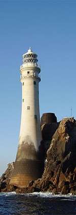
Tuskar Rock (Irish: An Tuscar)[3] is a group of rocks topped by a lighthouse 11 kilometres (6.8 miles) off the southeast coast of County Wexford, Ireland. It has probably destroyed more ships than any other Irish coastal feature.[4][5] One hundred and seventy-six wrecks are listed for the Tuskar Rock area at Irish Wrecks Online.[6]
 Tuskar Rock | |
 | |

| |
| Location | County Wexford |
|---|---|
| Coordinates | 52°12.175′N 6°12.445′W |
| Year first constructed | 1812–1815 |
| Year first lit | 1815 |
| Automated | 31 March 1993 |
| Construction | granite tower |
| Tower shape | cylindrical tower with balcony and lantern |
| Markings / pattern | white tower and lantern, red lantern rail |
| Tower height | 34 metres (112 ft) |
| Focal height | 33 metres (108 ft) |
| Original lens | Catoptric light |
| Current lens | Chance Brothers 500-millimetre (20-inch) annular lens |
| Intensity | 1 kilowatt lamp |
| Range | 24 nmi (44 km) |
| Characteristic | Q (2) W 7.5s |
| Admiralty number | A5838 |
| NGA number | 6540 |
| ARLHS number | IRE-076 |
| Ireland number | CIL-0470[1] [2] |
It is mentioned in the Irish ballad Tales of Loch Achray as the place where the clipper Loch Achray dropped her tug, before sailing to the South Atlantic where she was wrecked off the River Plate.
The Tuskar Rock lighthouse, built from granite and standing 120 feet (37 metres) tall, was built over a period of years beginning in 1812. In October of that year, a storm struck, washing away temporary barracks that had been erected on the island, and killing fourteen workmen—the worst such disaster in Ireland's history of lighthouse construction.[7] The surviving workers clung to the island's slippery rocks for two full days before being discovered and rescued.[7] Work resumed, and the lighthouse was completed, entering into operation on 4 June 1815.[7]
The Tuskar Rock air disaster occurred near the rock on 24 March 1968 when Aer Lingus flight 712, en route from Cork to London, crashed into the sea with the loss of all 61 people on board.
The name Tuskar rock has no foundation in the Irish language but actually came from the Vikings. It is one of many Viking place names found in the south of Wexford and means simply large (tu) rock (skar) in Old Norse.[8]
Demographics
| Historical population | ||||||||||||||||||||||||||||||||||||||||||||||||||||||||||||||||||||||||||||
|---|---|---|---|---|---|---|---|---|---|---|---|---|---|---|---|---|---|---|---|---|---|---|---|---|---|---|---|---|---|---|---|---|---|---|---|---|---|---|---|---|---|---|---|---|---|---|---|---|---|---|---|---|---|---|---|---|---|---|---|---|---|---|---|---|---|---|---|---|---|---|---|---|---|---|---|---|
|
| |||||||||||||||||||||||||||||||||||||||||||||||||||||||||||||||||||||||||||
| Source: Central Statistics Office. "CNA17: Population by Off Shore Island, Sex and Year". irishislands.info. Retrieved 12 October 2016. | ||||||||||||||||||||||||||||||||||||||||||||||||||||||||||||||||||||||||||||
See also
References
- Lighthouses Directory
- Tuskar Rock Lighthouse Commissioners of Irish Lights
- Tuskar Rock. Irish Placenames Database. Retrieved: 2010-10-22.
- Tuskar Rock. Commissioners for Irish Lights. Retrieved: 2010-10-22.
- Tuskar Rock. Commissioners for Irish Lights, 1997. Retrieved: 2010-10-22.
- Tuskar Rock. irishwrecksonline.net. Retrieved: 2010-10-23.
- Krauskopf, Sharma (2001) Irish Lighthouses; p.15.
- Billy Colfer (2004) The Hook Peninsula: County Wexford p30 Cork University Press ISBN 9781859183786
| Wikimedia Commons has media related to Tuskar Rock lighthouse. |