Valentia Island
Valentia Island (Irish: Dairbhre, meaning "The Oak Wood") is one of Ireland's most westerly points. It lies off the Iveragh Peninsula in the southwest of County Kerry. It is linked to the mainland by the Maurice O'Neill Memorial Bridge at Portmagee. A car ferry also departs from Reenard Point to Knightstown, the island's main settlement, from April to October. A second, smaller village named Chapeltown is located at roughly the midpoint of the island, 3 kilometres (1.9 miles) from the bridge. The permanent population of the island is 665 (as of the 2011 CSO Census).[2] It is approximately 11 kilometres (7 miles) long by almost 3 kilometres (2 miles) wide.
| Native name: Dairbhre | |
|---|---|
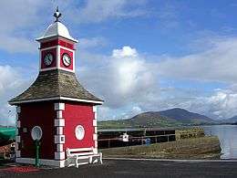 Knightstown Town clock | |
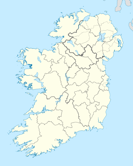 Valentia Island Valentia Island | |
| Geography | |
| Location | Atlantic Ocean |
| Coordinates | 51.9°N 10.35°W |
| Area | 25.7[1] km2 (9.9 sq mi) |
| Length | 11 km (6.8 mi) |
| Width | 3 km (1.9 mi) |
| Administration | |
| Province | Munster |
| County | Kerry |
| Largest settlement | Knightstown (pop. 156) |
| Demographics | |
| Population | 665 (2011) |
Name
The English name Valentia Island (also spelled Valencia Island) doesn't come exactly from the Spanish city of Valencia, but from a settlement on the island called An Bhaile Inse or Beal Inse ("mouth of the island" or "island in the mouth of the sound"), which in turn could have been reinterpreted as similar to the Spanish town by Englishmen and Spaniards sailors and settlers alike (there is a grave marker to Spanish sailors lost at sea in the Catholic cemetery at Kylemore).
History
Valentia was the eastern terminus of the first commercially viable transatlantic telegraph cable.[4] The first attempt in 1857[5] to land a cable from Ballycarbery Strand on the mainland just east of Valentia Island ended in disappointment. After subsequent failures of cables landed at Knightstown in 1858 and Foilhommerum Bay in 1865,[6] the vast endeavor finally resulted in commercially viable transatlantic telegraph communications from Foilhommerum Bay to Heart's Content, Newfoundland in 1866. Transatlantic telegraph cables operated from Valentia Island for one hundred years, ending with Western Union International terminating its cable operations in 1966.
Prior to the transatlantic telegraph, American longitude measurements had a 2,800-foot (850 m) uncertainty with respect to European longitudes. Because of the importance of accurate longitudes to safe navigation, the U.S. Coast Survey mounted a longitude expedition in 1866 to link longitudes in the United States accurately to the Royal Observatory in Greenwich. Benjamin Gould and his partner A. T. Mosman reached Valentia on 2 October 1866. They built a temporary longitude observatory beside the Foilhommerum Cable Station to support synchronized longitude observations with Heart's Content, Newfoundland. After many rainy and cloudy days, the first transatlantic longitude signals were exchanged between Foilhommerum and Heart's Content on October 24, 1866.
Saturday, May 21st 1927, Charles A. Lindbergh, on his solo flight from New York to Paris make his first landfall in Europe over Dingle Bay and Valentia island. On the 1927 Mercator chart used by the famous pilot, it was labeled Valencia.[7]
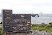
In 1993 an undergraduate geology student discovered fossilised tetrapod trackways, footprints preserved in Devonian rocks, on the north coast of the island at Dohilla (51°55′51″N 10°20′38″W). About 385 million years ago, a primitive vertebrate passed near a river margin in the sub-equatorial river basin that is now southwestern Ireland and left prints in the damp sand. The prints were preserved by silt and sand overlying them, and were converted to rock over geological time. The Valentia Island trackways are among the oldest signs of vertebrate life on land.[8][9]
| Historical population | ||||||||||||||||||||||||||||||||||||||||||||||||||||||||||||||||||||||||||||||||
|---|---|---|---|---|---|---|---|---|---|---|---|---|---|---|---|---|---|---|---|---|---|---|---|---|---|---|---|---|---|---|---|---|---|---|---|---|---|---|---|---|---|---|---|---|---|---|---|---|---|---|---|---|---|---|---|---|---|---|---|---|---|---|---|---|---|---|---|---|---|---|---|---|---|---|---|---|---|---|---|---|
|
|
| ||||||||||||||||||||||||||||||||||||||||||||||||||||||||||||||||||||||||||||||
| Source: Central Statistics Office. "CNA17: Population by Off Shore Island, Sex and Year". CSO.ie. Retrieved October 12, 2016. | ||||||||||||||||||||||||||||||||||||||||||||||||||||||||||||||||||||||||||||||||
Places of interest

The combined features and history of the island make it an attractive tourist destination, easily accessible from the popular Ring of Kerry route.
- Geokaun Mountain and Fogher Cliffs : the highest mountain on Valentia Island and the sea cliffs of 600 feet (180 m) on its northern face.
- On the northeast of the island stands Glanleam House amid sub-tropical gardens. Protected by windbreaks from Atlantic gales and never touched by frost, these gardens provide the mildest microclimate in Ireland. Starting in the 1830s, Sir Peter George Fitzgerald, the 19th Knight of Kerry (1808–1880),[10][11] planted these gardens and stocked them with a unique collection of rare and tender plants from the southern hemisphere, normally grown under glass in Ireland. The gardens are laid out in a naturalistic style as a series of walks. There are plants from South America, Australia, New Zealand (the tallest tree ferns in Europe), Chile and Japan. The gardens are memorialized in a selected golden-variegated Luma apiculata "Glanleam Gold" that originated as a sport in the garden. The gardens are open to the public.
- The slate quarry which reopened in 1998 provided slates for the British Houses of Parliament.[12]
- The island also hosts a heritage centre[13] which tells the story of the geology, human, natural and industrial history of the island, with exhibits on the Cable Station, the Marine Radio Station and the RNLI's Valentia Lifeboat Station.
- The Telegraph Field (or Longitude Field) is the site of the first permanent communications link between Europe and North America Transatlantic telegraph cables operated from Valentia Island from 1866.[6]
Gallery
 Dolmen Rock, western slope of Mt. Geokaun
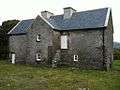 Balleyhearney House, Balleyhearney East. 'Famine Era' hospital adjacent to the Knights' Wood.
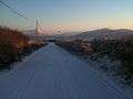 Rare snowy day, Main Road, Valentia Island looking toward Knightstown, Valentia Harbour and Cahirciveen
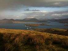 Portion of the view from the summit of Mt. Geokaun ("yo-kawn"). Valentia Harbour and Cahirciveen are in the background
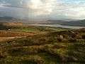 Portion of the view from the summit of Mt. Geokaun ("yo-kawn"). Valentia Harbour and Letter are in the background
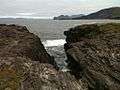 View from Culloo Rock. Dingle Peninsula, Dingle Bay and the north shore of Valentia Island (including Fogher Cliffs) are in the background.
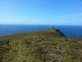 Bray Head view looking west with Skellig Islands in distance
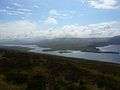 View of Portmagee Channel looking south-east from Bray Head
 Valentia lighthouse and surrounding fortifications
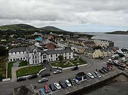 Knightstown
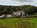 Glanleam House
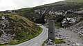 Valentia Slate Quarry
Climate
Valentia Island has an oceanic climate (Cfb). Valentia Island is, on average, the wettest weather station in Ireland. Valentia Island sits on the eastern edge of the Atlantic Ocean. Despite it being on the same latitude as St. Anthony in Newfoundland on the opposite side of the Atlantic Ocean, it enjoys much milder winters thanks to the moderating effect of prevailing west or south west winds, and the effects of the warming Gulf Stream current. Snow and frost are rare, and because of this the island can support many sub-tropical varieties of plants.
| Climate data for Valentia Island, County Kerry (1981–2010, extremes 1892–present) | |||||||||||||
|---|---|---|---|---|---|---|---|---|---|---|---|---|---|
| Month | Jan | Feb | Mar | Apr | May | Jun | Jul | Aug | Sep | Oct | Nov | Dec | Year |
| Record high °C (°F) | 14.8 (58.6) |
16.8 (62.2) |
20.7 (69.3) |
24.0 (75.2) |
27.2 (81.0) |
28.1 (82.6) |
29.7 (85.5) |
29.8 (85.6) |
28.4 (83.1) |
23.9 (75.0) |
19.8 (67.6) |
15.7 (60.3) |
29.8 (85.6) |
| Average high °C (°F) | 9.8 (49.6) |
9.8 (49.6) |
11.0 (51.8) |
12.5 (54.5) |
14.9 (58.8) |
16.7 (62.1) |
18.1 (64.6) |
18.2 (64.8) |
17.0 (62.6) |
14.3 (57.7) |
11.8 (53.2) |
10.3 (50.5) |
13.7 (56.7) |
| Daily mean °C (°F) | 7.3 (45.1) |
7.2 (45.0) |
8.2 (46.8) |
9.4 (48.9) |
11.6 (52.9) |
13.7 (56.7) |
15.4 (59.7) |
15.4 (59.7) |
14.1 (57.4) |
11.7 (53.1) |
9.3 (48.7) |
7.8 (46.0) |
10.9 (51.6) |
| Average low °C (°F) | 4.7 (40.5) |
4.6 (40.3) |
5.4 (41.7) |
6.3 (43.3) |
8.4 (47.1) |
10.8 (51.4) |
12.7 (54.9) |
12.6 (54.7) |
11.2 (52.2) |
9.0 (48.2) |
6.8 (44.2) |
5.3 (41.5) |
8.2 (46.8) |
| Record low °C (°F) | −7.2 (19.0) |
−7.3 (18.9) |
−5.1 (22.8) |
−2.3 (27.9) |
0.2 (32.4) |
1.7 (35.1) |
4.4 (39.9) |
3.3 (37.9) |
1.7 (35.1) |
−2.2 (28.0) |
−5.1 (22.8) |
−7.7 (18.1) |
−7.7 (18.1) |
| Average precipitation mm (inches) | 173.8 (6.84) |
123.7 (4.87) |
123.8 (4.87) |
96.7 (3.81) |
93.5 (3.68) |
95.3 (3.75) |
99.0 (3.90) |
114.9 (4.52) |
125.4 (4.94) |
177.1 (6.97) |
169.3 (6.67) |
164.9 (6.49) |
1,557.4 (61.31) |
| Average precipitation days (≥ 0.2 mm) | 22 | 19 | 21 | 17 | 17 | 17 | 19 | 19 | 19 | 22 | 22 | 22 | 236 |
| Average snowy days | 1.0 | 0.8 | 0.7 | 0.3 | 0.0 | 0.0 | 0.0 | 0.0 | 0.0 | 0.0 | 0.1 | 0.7 | 3.7 |
| Average relative humidity (%) | 79.2 | 76.2 | 75.0 | 72.4 | 72.9 | 76.7 | 80.0 | 78.5 | 77.2 | 78.4 | 79.6 | 79.9 | 77.2 |
| Mean monthly sunshine hours | 43.4 | 62.2 | 93.0 | 156.0 | 182.9 | 159.0 | 139.5 | 136.4 | 117.0 | 83.7 | 54.0 | 40.3 | 1,267.4 |
| Mean daily sunshine hours | 1.4 | 2.2 | 3.0 | 5.2 | 5.9 | 5.3 | 4.5 | 4.4 | 3.9 | 2.7 | 1.8 | 1.3 | 3.5 |
| Source: Met Éireann[14][15][16] | |||||||||||||
Sport
Valentia Young Islanders GAA is the local Gaelic Athletic Association club.
Valentia is a popular fishing location, and Valentia waters hold the Irish records for conger eel, red sea bream, Ray's bream and lesser spotted dogfish.
Notable people
- Helen Blackburn who was a leading women's rights campaigner in England was born here in 1842.[17]
- Valentia was considered home to Mug Ruith, a powerful blind druid in Irish mythology.
- The O'Sullivans, headed by the O'Sullivan Beare, owned much of Valentia until the 17th century.[18]
- The noted naturalist Maude Jane Delap lived and worked in Knightstown, carrying out important research into the marine life surrounding Valentia and identifying many new species.[19]
- Valentia is the home of former Gaelic footballer, Mick O'Connell and the birthplace of John J "Scéilig" O'Kelly, leader of Sinn Féin from 1926.
- Gaelic footballer Ger O'Driscoll was born on Valentia Island.
- The American solo rock climber Michael Reardon died on 13 July 2007 at the Fogher Cliffs of Valentia Island when he was swept out to sea following a successful climb.
- Gerald Spring Rice, 6th Baron Monteagle of Brandon was brought up on the island, as were many other members of the Spring Rice family.[20]
See also
References
- Knight, Charles (1867). The English Cyclopaedia: Geography. London: Bradbury, Evans, & Co. p. 387. Retrieved 7 March 2020.
Valentia Island, which has an area of 6,371 acres (25.78 km2) and is extemely fertile and tolerably well cultivated,[...]
- Electoral Division Valencia (CSO Area Code ED 19025). Census of Ireland 2011 (Report). 1 – Population Classified by Area. Central Statistics Office of Ireland. Valencia. Archived from the original on 3 December 2013. Retrieved 7 March 2020.
- "First Transatlantic Cable and First message sent to USA 1856 Memorial by Alan Hall". Archived from the original on 2011-07-07. Retrieved 2020-03-07.
Valentia Slate Memorial, showing cross cuts of cable spanning the Atlantic from 1853 to 1966, Year: 2006, Price: 4,500.00 (equivalent to £6,559 in 2019)
- The Atlantic Cable, Smithsonian Institution, USA.
- John R. Isaac, 1857 — Laying the Atlantic Telegraph Cable from Ship to Shore, History of the Atlantic Cable & Undersea Communications.
- Buchanan, Keith (2013-06-21). "The Telegraph Field with transatlantic telegraph cable station - Valentia Island, Ireland - Anglo American Cable House". Archived from the original on 2013-06-21. Retrieved 2020-03-07.
Also known as "The Longitude Field". Prior to the transatlantic telegraph, American longitude measurements had a 2,800 foot (850 m) uncertainty with respect to European longitudes. A temporary longitude observatory was built adjacent to the Foilhommerum Cable Station to facilitate synchronized longitude observations with Heart's Content, Newfoundland.
- Hampton, Dan (2017). The flight : Charles Lindbergh's daring and immortal 1927 Transatlantic crossing (First ed.). New York, NY: HarperCollins. p. 189. ISBN 978-0-06-246439-2. OCLC 957504448.
- Stössel, Iwan; Williams, Edward A.; Higgs, Kenneth T. (15 November 2016). "Ichnology and depositional environment of the Middle Devonian Valentia Island tetrapod trackways, south-west Ireland". Palaeogeography, Palaeoclimatology, Palaeoecology. 462: 16–40. doi:10.1016/j.palaeo.2016.08.033. ISSN 0031-0182.
- Niedźwiedzki, Grzegorz; Szrek, Piotr; Narkiewicz, Katarzyna; Narkiewicz, Marek; Ahlberg, Per E. (January 2010). "Tetrapod trackways from the early Middle Devonian period of Poland". Nature. 463 (7277): 43–48. doi:10.1038/nature08623. ISSN 1476-4687. PMID 20054388.
Supposed trackways of very early tetrapods have been recorded from a number of localities in Europe and Australia. [...] Two large trackways from Valentia Island, Ireland, have been dated radiometrically to 385 million years ago.[...]Figure 5 | Phylogenetic implications of tracks. [...]The bars are approximate measures of the uncertainty of dating. These are not statistical error bars but an attempt to reflect ongoing debate.
- "The FitzGerald (Knights of Kerry) Papers (MIC/639 and T/3075)". Public Record Office of Northern Ireland. 29 April 1998. Archived from the original on 2007-09-27. Retrieved 7 March 2020.
- "Introduction to the FitzGerald (Knights of Kerry) Papers (T3075)" (PDF). Public Record Office of Northern Ireland. November 2007. p. 10. Archived (PDF) from the original on 2 September 2016. Retrieved 2020-03-07.
He showed a keen interest in everything which had a practical bearing on the progress or prosperity of Ireland and, predictably, he was most co-operative in the establishment of the trans-Atlantic cable station at Valentia.
- Condon, Des (2006). "Valentia Island". Cromane Community Council. Archived from the original on 2008-05-21.
- "Valentia Heritage Centre". Knightstown, Valentia Island, Co. Kerry, Ireland. Archived from the original on 28 September 2007. Retrieved 2020-03-07.
- "Valentia 1981–2010 averages". Met Éireann. Retrieved 13 October 2016.
- "Absolute Maximum Air Temperatures for each Month at Selected Stations" (PDF). Met Éireann. Retrieved 13 October 2016.
- "Absolute Minimum Air Temperatures for each Month at Selected Stations" (PDF). Met Éireann. Retrieved 13 October 2016.
- Walker, Linda (2004). "Blackburn, Helen (1842–1903), campaigner for women's rights". Oxford Dictionary of National Biography (online ed.). Oxford University Press. doi:10.1093/ref:odnb/31905. (Subscription or UK public library membership required.)
- Barnard, Toby (2004). "O'Sullivan Beare, Philip (b. c.1590, d. in or after 1634)". Oxford Dictionary of National Biography (online ed.). Oxford University Press. doi:10.1093/ref:odnb/20913. (Subscription or UK public library membership required.)
- Mulvihill, Mary (2003). Ingenious Ireland: A County-by-County Exploration of the Mysteries and Marvels of the Ingenious Irish. Dublin: Simon and Schuster. pp. 397–398. ISBN 0684020947. Retrieved 10 November 2014.
- "Obituary: Captain The Lord Monteagle of Brandon". The Guards Magazine. Archived from the original on 2014-09-03. Retrieved 16 March 2018.
External links
- Valentia Island Portal
- Valentia Heritage Centre
- Valentia Island Annual Music Festival
- Travel Information
- The Tetrapod Trackways
- The Laying of the Atlantic Telegraph Cable
- Telegraph Cable History Trail
- Cable History at the Valentia Heritage Centre
- Alan Hall - Sculptor of the First Transatlantic Cable and First message sent to USA 1856 Memorial
- Submarine Telegraphs, Their History, Construction, and Working by Charles Bright
- Linking European and American Longitude
- IEEE History Center: County Kerry Transatlantic Cable Stations, 1866
- The Transatlantic Longitude as Determined by the Coast Survey Expedition of 1866
- Valentia Island Sea Angling
- The Telegraph Field - Valentia Island
- Irelandbyways site Valentia Information
- Valentia Island
Further reading
- Browne, E.T., The fauna and flora of Valencia Harbour on the west coast of Ireland. Proc. R.Ir. Acad., ser.3,5, 667-854
![]()
Castles and Historic Houses - Connacht | ||
|---|---|---|
| Connacht |
|  |
See also: Historic houses in Northern Ireland • Historic houses in the Republic of Ireland | ||
Places in County Kerry | ||
|---|---|---|
| Towns | 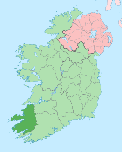 | |
| Parishes, Villages and Townlands |
| |
| Islands | ||
| ||