List of lighthouses in France
France homeland
| Name | Image | Water body | Departement | Location & coordinates |
Year built | Notes |
|---|---|---|---|---|---|---|
| Phare du Cap Leucate | %2C_light_house.jpg) |
Gulf of Lion | Aude | Cap Leucate 42°54′5″N 003°03′3″E |
1950 | |
| Planier Light | 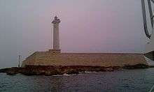 |
Gulf of Lion | Bouches-du-Rhône | Île du Planier (Planier island) 43°11′54.83″N 5°13′51.29″E |
1959 | The first tower was built in this location in 1320 by Robert d'Anjou. |
| Giraglia | 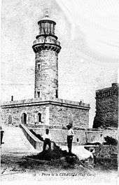 |
Ligurian Sea | Haute-Corse | Giraglia Island, north off Cap Corse | 1848[1] | |
| Héaux de Bréhat Lighthouse | 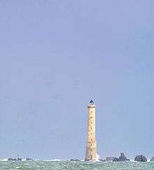 |
Atlantic Ocean | Côtes-d'Armor | Île-de-Bréhat 48°54′30″N 3°5′15″W |
1840 | |
| Ploumanac'h Lighthouse | 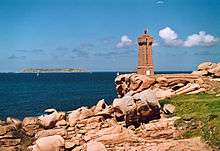 |
Atlantic Ocean | Côtes-d'Armor | Perros-Guirec 48°50′15″N 3°29′0″W |
1946 | An older lighthouse dating from 1860 was destroyed in 1944 and replaced by the current structure. |
| Roches-Douvres Light | 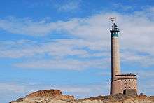 |
Atlantic Ocean | Côtes-d'Armor | Roches-Douvre reef between Île-de-Bréhat and Guernsey 49°6′18″N 2°48′50″W |
1954 | At a height of 213 feet (65 m) it is the eleventh-tallest "traditional lighthouse" in the world.[2] |
| Sept-Îles Lighthouse |  |
Atlantic Ocean | Côtes-d'Armor | Perros-Guirec 48°52′43″N 3°29′24″W |
1854 | The first lighthouse, a round tower, was illuminated in May 1835, and then replaced in 1854 by a square tower 16 ft (5 m) taller. Destroyed 4 August 1944, it was rebuilt in 1949 and relit in July 1952. |
| Triagoz Lighthouse | 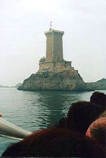 |
Atlantic Ocean | Côtes-d'Armor | Triagoz archipelago 48°52′17″N 3°38′47″W |
1864 | |
| Ar Men | 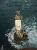 |
Atlantic Ocean | Finistère | West off Île de Sein 48°3′0″N 4°59′54″W |
1881 | |
| Phare d'Eckmühl |  |
Atlantic Ocean | Finistère | Penmarc'h 47°47′19.55″N 4°22′22.23″W |
1897 | The current tower replaced an older lighthouse constructed in 1835. |
| La Vieille | 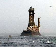 |
Atlantic Ocean | Finistère | Raz de Sein 48°02′26″N 4°45′23″W |
1887 | |
| Phare du Créac'h |  |
Atlantic Ocean | Finistère | Ushant island 48°27′34.23″N 5°7′45.4″W |
1863 | |
| Saint-Mathieu Lighthouse | 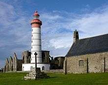 |
Atlantic Ocean | Finistère | Pointe Saint-Mathieu 48°19′48″N 4°46′15″W |
1835 | The lighthouse was classified as a monument historique on 23 May 2011.[3][4] |
| Île Vierge Lighthouse | 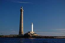 |
Atlantic Ocean | Finistère | Île Vierge 48°38′19.9″N 4°34′03.0″W |
1902 | The current tower replaced an older lighthouse from 1845. The island is open to the public from April to September, as is the lighthouse, by appointment.[5] |
| La Jument | 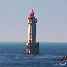 |
Atlantic Ocean | Finistère | Off Ushant island 48°25′0″N 5°7′59″W |
1911 | Jean Guichard's 1989 dramatic storm photo shots of the Jument Lighthouse became an instant hit and earned him the 2nd place in the 1991 World Press Photo award.[6] |
| Petit Minou Lighthouse | 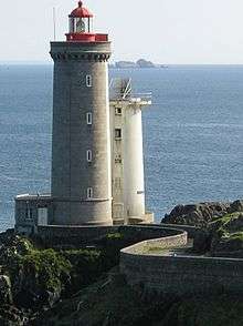 |
Atlantic Ocean | Finistère | Roadstead of Brest 48°20′12″N 4°36′51″W |
1848 | Together with the Phare du Portzic, Petit Minou Lighthouse forms a range of lights into the roadstead.[7] |
| Phare du Portzic |  |
Atlantic Ocean | Finistère | Roadstead of Brest 48°21′30″N 4°32′03″W |
1848 | Together with the Petit Minou Lighthouse, Portzic Lighthouse forms a range of lights into the roadstead.[7] |
| Tourelle de la Plate | 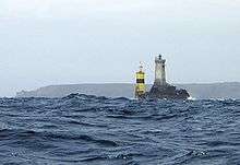 |
Atlantic Ocean | Finistère | Raz de Sein 48°2′21″N 4°45′35″W |
1910[7] | |
| Phare de Tévennec | 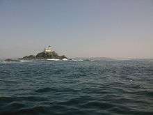 |
Atlantic Ocean | Finistère | Raz de Sein | 1875[7] | |
| Phare de Nividic | 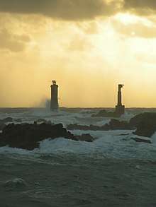 |
Atlantic Ocean | Finistère | Ouessant 48°26′44″N 5°09′03″W |
1936 | At a longitude of 5°09.1' W, this is France's westernmost lighthouse.[8] |
| Phare de l'île aux Moutons | .jpg) |
Atlantic Ocean | Finistère | On an islet 11 kilometres (6.8 mi) southeast of Bénodet | 1879[7] | |
| Phare de l'île Tristan |  |
Atlantic Ocean | Finistère | Tristan Island off Douarnenez | 1865[7] | |
| Phare du Millier | 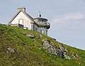 |
Atlantic Ocean | Finistère | On a headland in the southern part of the Baie de Douarnenez[7] | 1881 | |
| Phare des Pierres Noires | 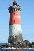 |
Atlantic Ocean | Finistère | On an islet 9 kilometres (5.6 mi) west off Pointe Saint-Mathieu[8] | 1872 | |
| Phare de Penfret |  |
Atlantic Ocean | Finistère | Penfret, Glénan islands[7] | 1837 | |
| Phare de Roscoff | 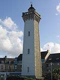 |
Atlantic Ocean | Finistère | Roscoff | 1917[8] | |
| Phare de l'île de Batz | 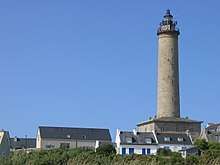 |
Atlantic Ocean | Finistère | Île de Batz | 1836 | The lighthouse replaced an earlier building from 1705.[8] |
| Phare de Pontusval | 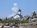 |
Atlantic Ocean | Finistère | 2 kilometres (1.2 mi) northwest of Brignogan-Plages[8] | 1869 | |
| Le Four Light | 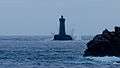 |
Atlantic Ocean | Finistère | At the northern entrance to the Chenal du Four[8] | 1874 | |
| Phare de l'Espiguette |  |
Gulf of Lion | Gard | Pointe de l'Espiguette 43°29′16″N 4°8′31″E |
1869 | |
| Cordouan Lighthouse | 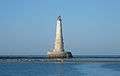 |
Bay of Biscay | Gironde | Gironde estuary 45°35′10.84″N 1°10′24.48″W |
1611 | The original tower was raised to 68 metres (223 ft) in the late 18th century. |
| Phare de Gatteville | 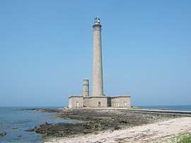 |
English Channel | Manche | Barfleur 49°41′47.12″N 1°15′57.29″W |
1774 | At a height of 75 metres (246 ft) it is the third tallest "traditional lighthouse" in the world.[2] |
| Goulphar Lighthouse | .jpg) |
Bay of Biscay | Morbihan | Belle-Île-en-Mer 47°18′40″N 3°13′39″W |
1836[9] | |
| Phare de La Teignouse |  |
Bay of Biscay | Morbihan | Quiberon 47°27′27″N 3°2′45″W |
1845 | |
| Dunkirk Lighthouse | 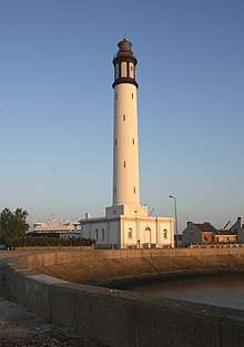 |
English Channel | Nord | Near Dunkirk 51°02′56″N 02°21′51″E |
1843 | |
| Phare de Sainte Marie | 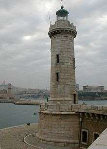 |
Gulf of Lion | Provence-Alpes-Côte d'Azur | Marseille harbour | 1855 | The lighthouse is now inactive. |
| Île d'Yeu Lighthouse | 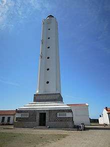 |
Bay of Biscay | Vendée | Île d'Yeu 46°43′03″N 2°22′56″W |
1950 | The structure, designed by Maurice Durand, is the third serving the site; the original tower, constructed in 1830, was destroyed by German troops near the close of World War II.[10] |
| L'Armendèche Lighthouse | 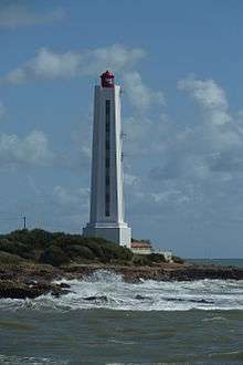 |
Bay of Biscay | Vendée | Les Sables-d'Olonne 46°29′23″N 01°48′17″W |
1968 | The lighthouse was designed by Maurice Durand. |
| Pointe des Corbeaux Lighthouse | 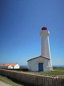 |
Bay of Biscay | Vendée | Île d'Yeu 46°41′24″N 2°17′06″W |
1950 | The lighthouse was designed by Maurice Durand. |
| Pointe du Grouin du Cou Lighthouse |  |
Bay of Biscay | Vendée | Pointe du Grouin du Cou 46°20′40″N 1°27′49″W |
1953 | The lighthouse was designed by Maurice Durand. |
French Overseas Departments and Territories
French Southern and Antarctic Lands
| Name | Image | Year built | Location & coordinates | Class of Light | Focal height | NGA number | Admiralty number | Range nml |
|---|---|---|---|---|---|---|---|---|
| Anchorage Range Front Lighthouse | n/a | Port-aux-Français 49°21′17.3″S 70°12′16.4″E | Q R | 7 metres (23 ft) | 33108 | K0821.4 | 12 | |
| Anchorage Range Rear Lighthouse | n/a | Port-aux-Français 49°21′14.3″S 70°12′13.8″E | F R | 21 metres (69 ft) | 33112 | K0821.41 | 12 | |
| Baie du Morbihan Range Front Lighthouse | Image | n/a | Kerguelen Islands 49°21′07.8″S 70°04′45.4″E | Q W | 5 metres (16 ft) | 33100 | K0820.4 | 12 |
| Baie du Morbihan Range Rear Lighthouse | Image | n/a | Kerguelen Islands 49°20′58.9″S 70°04′31.4″E | Q W | 20 metres (66 ft) | 33104 | K0820.41 | 12 |
| Île Channer Lighthouse | n/a | 49°22′54.0″S 70°11′06.0″E | Q (9) W 15s. | 10 metres (33 ft) | 33107 | K0821.5 | 6 | |
| Île Europa Lighthouse | 1994 | Europa Island ~ 22°20′27.9″S 40°20′45.6″E | Fl R 5s. | 21 metres (69 ft) | 32598 | D7026.5 | 15 | |
| Île Juan de Nova Lighthouse | Image | 2001 | Juan de Nova Island 17°02′55.2″S 42°42′36.0″E | Fl R 4s. | 37 metres (121 ft) | 32624 | D7033 | 8 |
| Île Murray Lighthouse | n/a | Kerguelen Islands 49°30′53.3″S 70°15′44.5″E | Fl (3) W 12s. | 49 metres (161 ft) | 33106 | K0819 | 11 | |
| Île Tromelin Lighthouse |  | ~1970s | Tromelin Island 15°53′15.5″S 54°31′13.5″E | Fl R 4s. | 15 metres (49 ft) | 32884 | D7073 | 8 |
| Pointe Molloy Lighthouse | Image | n/a | Kerguelen Islands 49°22′06.7″S 70°04′58.5″E | Fl R 2.5s. | 15 metres (49 ft) | 33096 | K0820 | 3[11][12] |
French Guiana
French Polynesia
Guadeloupe
Mayotte
Martinique
New Caledonia
Réunion
Saint Barthélemy
Saint Pierre and Miquelon
Wallis and Futuna
See also
References
- Rowlett, Russ (10 March 2015). "Lighthouses of Corsica". The Lighthouse Directory. University of North Carolina at Chapel Hill. Retrieved 3 July 2015.
- Rowlett, Russ. "The Tallest Lighthouses". The Lighthouse Directory. University of North Carolina at Chapel Hill. Retrieved 3 July 2015.
- "Notice No PA29000050" (in French). French Ministry of Culture.
- "Classement au titre des monuments historiques de plusieurs phares ou anciens phares du littoral" [Classification of many lighthouses and old coast lighthouses as historic monuments] (in French). 22 November 2010. Archived from the original on 4 June 2012. Retrieved 27 October 2013.
- "Phare de l'île Vierge". Sécurité maritime – Les Phares et Balises (in French). Ministry of Ecology, Energy, Sustainable Development and Sea. 30 June 2006. Archived from the original on 20 July 2011. Retrieved 19 December 2009.
- "1991 Photo Contest". World Press Photo. Retrieved 5 July 2015.
- Rowlett, Russ (30 March 2014). "Lighthouses of Brittany: Southern Finistère". The Lighthouse Directory. University of North Carolina at Chapel Hill. Retrieved 5 July 2015.
- Rowlett, Russ (6 April 2014). "Lighthouses of France: Northern Finistère". The Lighthouse Directory. University of North Carolina at Chapel Hill. Retrieved 5 July 2015.
- Rowlett, Russ (21 March 2014). "Lighthouses of France: Morbihan". The Lighthouse Directory. University of North Carolina at Chapel Hill. Retrieved 5 July 2015.
- Rowlett, Russ (6 March 2014). "Lighthouses of France: La Vendée". The Lighthouse Directory. University of North Carolina at Chapel Hill. Retrieved 5 July 2015.
- French Southern and Antarctic Lands The Lighthouse Directory. University of North Carolina at Chapel Hill. Retrieved 3 Novenberr 2016
- NGA List of Lights – Pub.112 Retrieved 3 November 2016
External links
| Wikimedia Commons has media related to Lighthouses in France. |
- lighthousesRus.org (French listing)
- Rowlett, Russ. "The Lighthouse Directory". University of North Carolina at Chapel Hill.
- Marc de Kleijn: Lighthouses of France
| Types |
| _-_cropped.jpg) | ||||
|---|---|---|---|---|---|---|
| Fixtures | ||||||
| Maintenance | ||||||
| Locations | ||||||
| Categories |
| |||||
| Global organizations | ||||||
| ||||||
Lighthouses and lightvessels in Europe | |
|---|---|
| Sovereign states |
|
Dependencies and other territories |
|
This article is issued from Wikipedia. The text is licensed under Creative Commons - Attribution - Sharealike. Additional terms may apply for the media files.