Dungarvan
Dungarvan (Irish: Dún Garbhán, meaning "Garbhann's Fort") is a coastal town and harbour in County Waterford, on the south-east coast of Ireland. Prior to the merger of Waterford County Council with Waterford City Council in 2014, Dungarvan was the county town and administrative centre of County Waterford. Waterford City and County Council retains administrative offices in the town.[2][3] The town's Irish name means "Garbhann's fort", referring to Saint Garbhann who founded a church there in the seventh century.[4] The town lies on the N25 road (European route E30), which connects Cork, Waterford and Rosslare Europort.
Dungarvan Irish: Dún Garbhán | |
|---|---|
Town | |
 | |
 Coat of arms | |
| Motto(s): Ní Maraidhe Go Stiúrthóir Not a Mariner Till a Steersman | |
 Dungarvan Location in Ireland | |
| Coordinates: 52.0845°N 7.6397°W | |
| Country | Ireland |
| Province | Munster |
| County | Waterford |
| Area | |
| • Town | 4.63 km2 (1.79 sq mi) |
| Elevation | 1 m (3 ft) |
| Population (2016)[1] | |
| • Urban | 9,227 |
| • Environs | 1,436 |
| Time zone | UTC±0 (WET) |
| • Summer (DST) | UTC+1 (IST) |
| Eircode routing key | X35 |
| Telephone area code | +353(0)58 |
| Irish Grid Reference | X259930 |
| Website | waterfordcoco.ie |
Location and access
Dungarvan is situated at the mouth of the Colligan River, which divides the town into two parishes - that of Dungarvan to the west, and that of Abbeyside to the east -, these being connected in three places by a causeway and single-span bridge built by the Dukes of Devonshire starting in 1801;[5] by an old railway bridge; and by a ring-road causeway and bridge.
History
_-_BL.jpg)
Dungarvan was incorporated in the 15th century, was represented by two members in the Irish Parliament until the Act of Union in 1801, and returned one member to the Westminster Parliament until 1885. Unlike nearby Waterford and Duncannon, Dungarvan surrendered without a siege in the Cromwellian conquest of Ireland (1649–53).
The 1921 Burgery ambush, an incident in the Irish War of Independence, took place near the town.
 Dungarvan harbour
 The old cemetery in Dungarvan
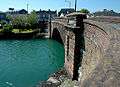 Devonshire Bridge
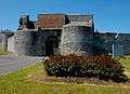 Dungarvan Castle
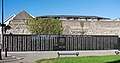 The Waterford Memorial next to Dungarvan Castle
Antiquities
A castle, commissioned around the 12th-13th centuries by King John of England, stands by the harbour. But no trace of the walls John built remain. The remains of a woolly mammoth were discovered in the town in 1859 by postmaster and amateur antiquarian Edward Brenan.
Irish Language
Just over 3% of the town's population, or 242 persons are daily Irish speakers, outside of the education system. (Census 2011).[6] Education through the medium of Irish is available at pre-school and primary level in the town in the local Gaelscoil, Scoil Garbhán. The Irish Language Officer of Waterford City and County Council is based in Dungarvan.
There are a range of activities and projects undertaken to strengthen the Irish language in the town. An Irish in Business award was established in 2009 to recognise businesses in Dungarvan and West Waterford who work to promote the Irish language.[7]
The town is home to an office of Glór na nGael, a national body that promotes the Irish language in three areas, the language in the family, in Business and enterprise, and community development. The Dungarvan office is responsible for Glór na nGael’s work across South Leinster and most of Munster.[8]
There is also significant contact between the town and the nearby Gaeltacht area of Ring, County Waterford and Old Parish which make up Gaeltacht na nDéise. Dungarvan has been identified as a potential Gaeltacht Service Town under the Gaeltacht Act 2012.[9] Under the Gaeltacht Act 2012, Gaeltacht Service Towns are defined as those towns situated in or adjacent to Gaeltacht Language Planning Areas and which have a significant role in providing public services, recreational, social and commercial facilities for those areas. Under the act, a language plan for the town will be developed. The aim of the language plan will be to enhance the use of the Irish language in the town.
Geography
Dungarvan is situated at the mouth of the Colligan River. Dungarvan Harbour as such is formed by The Quay (on the town side) and The Causeway. A single-span bridge was built in the late 18th century by Lord Devonshire to link Dungarvan with Abbeyside and indeed Waterford via said causeway. Outside the harbour, a 3-kilometre (1.9 mi) sandbar, "The Cunnigar" (Irish An Coinigéar) defines the western limit of the 4-kilometre (2.5 mi) wide Dungarvan Bay. The Cunnigar encloses the estuary of the River Brickey which flows out to sea at Abbeyside without actually joining the Colligan. The two estuaries are separated by "The Point".
| Historical population | ||
|---|---|---|
| Year | Pop. | ±% |
| 1813 | 4,930 | — |
| 1821 | 5,105 | +3.5% |
| 1831 | 6,527 | +27.9% |
| 1841 | 8,625 | +32.1% |
| 1851 | 6,865 | −20.4% |
| 1861 | 5,886 | −14.3% |
| 1871 | 6,520 | +10.8% |
| 1881 | 6,306 | −3.3% |
| 1891 | 5,263 | −16.5% |
| 1901 | 4,850 | −7.8% |
| 1911 | 4,977 | +2.6% |
| 1926 | 5,207 | +4.6% |
| 1936 | 5,361 | +3.0% |
| 1946 | 5,276 | −1.6% |
| 1951 | 5,423 | +2.8% |
| 1956 | 5,394 | −0.5% |
| 1961 | 5,188 | −3.8% |
| 1966 | 5,380 | +3.7% |
| 1971 | 5,583 | +3.8% |
| 1981 | 6,631 | +18.8% |
| 1986 | 6,849 | +3.3% |
| 1991 | 6,920 | +1.0% |
| 1996 | 7,175 | +3.7% |
| 2002 | 7,452 | +3.9% |
| 2006 | 8,362 | +12.2% |
| 2011 | 9,427 | +12.7% |
| 2016 | 9,227 | −2.1% |
| [10] | ||
Religion
A friary in Abbeyside, founded by Augustinians in the 13th century, is partially incorporated with the structure of a 20th-century Roman Catholic church. One of the most significant colleges in the town was also founded by these Augustinians whose order survives and maintains an Augustinian church nearer to Main Street.[11]
Toponymy
In everyday local usage, "Dungarvan" is taken to refer to the western, more commercial half of the town, where the administrative buildings and shopping areas are situated.[12]
Transport
Road
It is positioned on the N25 national primary road and the R672 and R675 regional roads.
Maritime
The town is separated from the open ocean by a shallow, eastward-facing bay. At its mouth, the bay is about two miles wide, with Dungarvan lying about four miles from the mouth. A meandering navigation channel marked by red/green buoys leads into Dungarvan from the ocean. For most vessels (except small dinghies) this channel is not navigable at low tide. Even at high tide, cruising yachts and larger vessels must be careful to remain in the buoyed channel. There is a well-maintained concrete slipway in Dungarvan town, suitable for launching vessels up to eight metres in length. However, larger vessels should only use it up to three hours either side of high tide. Moorings are usually made available to visiting yachts by Dungarvan Harbour Sailing Club, often free of charge.
Bus
Dungarvan is served by several routes. The main bus stop is located at Davitt's Quay. Other stops can be found at the shopping centre, Sexton Street and The Spring.
The Cork to London Eurolines coach provides a daily overnight cross channel service each way whereas Bus Éireann Expressway route 40 runs hourly in each direction providing a link to Cork, Waterford and Rosslare Europort. The company's route 362 provides a commuter link to Waterford. Several Local Link (formerly known as Déise Link) bus services terminate in the town. The main route is that to Tallow via Lismore with four services a day each way Mondays to Saturdays inclusive. Connections for Fermoy can be made at Tallow.[13]
Dublin Coach serve the town on its M9 Cork to Dublin route via Waterford, passing through every two hours.
Industry
One of the few major manufacturing facilities for GlaxoSmithKline consumer products is located in Dungarvan, employing more than 700 people. The town is also the home of Radley Engineering, the company responsible for manufacturing the Spire of Dublin. In days now gone, Dungarvan had a thriving tannery, a distillery, a gasworks, and a fishing fleet. In the latter 20th century, a major source of trade and employment was Dungarvan Cooperative (Creamery), which firmly bonded the town of Dungarvan with its agricultural hinterland.
International relations
Twin towns – Sister cities
Dungarvan has been twinned with Erie, Pennsylvania in the US since March 2007. Mercyhurst College, located in Erie, hosts the Global Intelligence Forum held annually in Dungarvan.
Entente Florale
Dungarvan is a 2018 participant representing Ireland's towns in Entente Florale, an international competition organised by the AEFP, the European Association for Flowers and Landscape. AEFP is a non profit organisation, and its overall aims are social and cultural development to enhance Horticulture, Tourism & Environment.
Literature
The British Poet Laureate, Sir John Betjeman (who lived in Ireland from 1941 to 1943) mentions Dungarvan in his poem, "The Irish Unionist's Farewell to Greta Hellstrom". Each stanza closes with the line, "Dungarvan in the rain".
Dungarvan is referred to in the collection of short stories Labyrinths by Jorge Luis Borges: "He was Irish, from Dungarvan. Having said this, he stopped short, as if he had revealed a secret."
Poet Mai O'Higgins was born on Saint Mary Street in the town centre.[16]
Dungarvan is also mentioned in the 2002 novel The Story of Lucy Gault by William Trevor.
People
- Physicist and Nobel Laureate Ernest Thomas Sinton Walton (6 October 1903 – 25 June 1995) was born in Abbeyside, near Dungarvan, to a Methodist minister father, Rev. John Walton (1874–1936) and Anna Sinton (1874–1906).[17] Walton was famous for his work with John Cockcroft on the splitting of the atom. The "Walton Causeway Park" in Abbeyside was dedicated in his honour. Walton himself attended the ceremony in 1989. After his death, a plaque was placed on the site of his birthplace in Abbeyside.
- John Deasy
- Austin Deasy
- Maura Derrane
See also
- Abbeyside, near the Dungarvan urban area, on the northern side of the Colligan River.
- Dungarvan Town Council, Local authority in Dungarvan stretches back before surviving records, the earliest reference in 1463 when described in a Wexford parliament meeting of Edward IVs as an asset the King of Ireland, until destroyed in war
- List of towns and villages in Ireland
- Market Houses in Ireland
References
- "Sapmap Area: Settlements Dungarvan". Census 2016. Central Statistics Office. 2016.
- "County Waterford In Context". Waterford City and County Council.
- Local Electoral Area Boundary Committee Report 2013p. 124: The new local electoral area in the west of the county acknowledges the position and status of Dungarvan, which is currently the 'county' town of Waterford County Council and has a town council.
- History Dungarvan
- "Factual - Key Dates in the History of Dungarvan - Waterford County Museum". www.waterfordmuseum.ie.
- Census 2011
- "Irish Language" (PDF). Archived from the original (PDF) on 4 March 2016. Retrieved 30 December 2015. GRADAM GNÓ NA nDÉISE Irish in Business Awards 2016 - Waterford City and County Council
- "Glór na nGael office in Dungarvan - Glór na nGael".
- "Gaeltacht Service Towns". Department of Arts, Heritage and the Gaeltacht. 3 December 2015. Archived from the original on 4 March 2016. Retrieved 30 December 2015.
- "Post 2002 figures include environs of Dungarvan". For a discussion on the accuracy of pre-famine census returns see JJ Lee "On the accuracy of the pre-famine Irish censuses" in Irish Population, Economy and Society edited by JM Goldstrom and LA Clarkson (1981) p54, and also "New Developments in Irish Population History, 1700–1850" by Joel Mokyr and Cormac Ó Gráda in The Economic History Review, New Series, Vol. 37, No. 4 (Nov. 1984), pp. 473–488
- "The History Of The Augustinians In Dungarvan". www.thefriarydungarvan.ie.
- "Photo Archive - Waterford County Museum". www.waterfordmuseum.ie. Retrieved 4 March 2020.
- "Archived copy" (PDF). Archived from the original (PDF) on 26 January 2016. Retrieved 9 January 2016.CS1 maint: archived copy as title (link)
- "Dungarvan". Eiretrains.com. Retrieved 22 November 2019.
- "Deise Greenway, the Waterford Greenway group". Deisegreenway.com. Retrieved 22 November 2019.
- Waterford News & Star – Friday, October 08, 2004 – "Mai O’Higgins back on song" Archived 22 June 2011 at the Wayback Machine
- "The Nobel Prize in Physics 1951". NobelPrize.org.
External links
| Wikimedia Commons has media related to Dungarvan. |
Places in County Waterford | ||
|---|---|---|
| Towns | 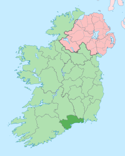 | |
| Villages and Townlands |
| |
| ||
| Authority control |
|
|---|