Longreach, Queensland
Longreach is a town and a locality in the Longreach Region, Queensland, Australia.[2][3] In the 2016 census, Longreach had a population of 2,970 people.[1] It is the administrative centre of the Longreach Regional Council, which was established in 2008 as a merger of the former Longreach, Ilfracombe, and Isisford shires.
| Longreach Queensland | |||||||||||||||
|---|---|---|---|---|---|---|---|---|---|---|---|---|---|---|---|
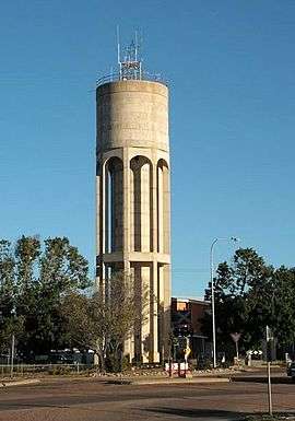 Longreach: the river water tower | |||||||||||||||
 Longreach | |||||||||||||||
| Coordinates | 23.4422°S 144.2491°E | ||||||||||||||
| Population | 2,970 (2016 census)[1] | ||||||||||||||
| • Density | 0.12642/km2 (0.3274/sq mi) | ||||||||||||||
| Established | 1888 | ||||||||||||||
| Postcode(s) | 4730 | ||||||||||||||
| Elevation | 191.0 m (627 ft)2209.5 | ||||||||||||||
| Area | 23,492.3 km2 (9,070.4 sq mi) | ||||||||||||||
| Time zone | AEST (UTC+10:00) | ||||||||||||||
| Location | |||||||||||||||
| LGA(s) | Longreach Region | ||||||||||||||
| State electorate(s) | Gregory | ||||||||||||||
| Federal Division(s) | Maranoa | ||||||||||||||
| |||||||||||||||
| |||||||||||||||

Geography
Longreach is in Central West Queensland, approximately 700 km (430 mi) from the coast, west of Rockhampton. The town is on the Tropic of Capricorn in the south-east of the locality. The town is named after the "long reach" of the Thomson River on which it is situated.
Lochern National Park is in the south-western part of the locality (formerly in Vergemont).[4]
The main industries of the area are cattle, sheep, and, more recently, tourism.
The Landsborough Highway enters the locality from the south-east (Ilfracombe), passes through the town and then exits to the north-west (Corfield). The Central Western railway line takes the same route, the town being served by the Longreach railway station. The Thomson Developmental Road commences at the town and passes through the south-east of the locality (briefly passing through the westernmost part of Ilfracombe) before exiting to the south (Stonehenge).[4]
In Longreach, the streets are named after species of birds, with the streets running east–west named after water birds and those running north–south after land birds.[5] The main business street is called Eagle Street. Other streets honour Hudson Fysh, an Australian aviation pioneer, and Sir James Walker, a farmer and long-serving mayor of the former Longreach Shire Council.
History
Longreach lay on the traditional tribal lands of the Iningai people. Iningai (also known as Yiningay, Muttaburra, Tateburra, Yinangay, Yinangi) is an Australian Aboriginal language spoken by the Iningai people. The Iningai language region includes the landscape within the local government boundaries of the Longreach Region, particularly the towns of Longreach, Barcaldine, Muttaburra and Aramac as well as the properties of Bowen Downs and catchments of Cornish Creek and Alice River.[6]
Kuungkari (also known as Kungkari and Koonkerri) is a language of Western Queensland. The Kuungkari language region includes the landscape within the local government boundaries of Longreach Shire Council and Blackall-Tambo Shire Council.[7]
The town was gazetted in 1887.[8]
Longreach Post Office opened on 1 October 1891.[9]
The Central Western railway line reached the town on 15 February 1892,[10] causing the population to grow.
Longreach State School opened on 22 May 1893 with an enrolment of 102 students.[11]
Our Ladies' College was established in 1900 as a primary school by the Presentation Sisters. St Joseph's Primary School was established in 1925. In 1935 Our Ladies' College expanded to offer secondary education to Year 10 (the first secondary school in Central Western Queensland).[12]
Cominos Brothers opened a cafe in Eagle Street, the town’s main street in 1911.[13] The cafe was known as Comino Bros. Central Café and American Bar, probably because it had an American-style soda fountain.[14]
Longreach Rail Post Office opened by April 1940 and closed in 1962.[9]
Longreach State High School opened on 24 January 1966.[15]
Evesham State School opened in the former Morella on 23 January 1967. It was mothballed on 31 December 2009 and then permanently closed on 31 December 2010.[16][17]
On 1 January 1986 Our Ladies' College relocated to the St Joseph's site.[12] A pre-school was added in 1992. It returned to being only a primary school (P-6) at the end of 1994. In 2002, the school changed its name to Our Ladies' School.[12]
Longreach School of Distance Education (also known as Longreach School of the Air) opened on 27 January 1987.[18][19]
In early April 2010, Longreach experienced a significant locust plague described by local residents as the worst in three decades.[20][21]
At the 2011 census, Longreach recorded a population of 3,137.[22]
In January 2019, it was decided to reduce the number of localities within Longreach Region by amalgamating the localities to the north and west of the town of Longreach into the locality of Longreach. The localities amalgamated were: Camoola, Chorregon, Ernestina, Maneroo, Morella, Tocal, and Vergemont.[23] As a consequence of this amalgamation, the Longreach Region has only three localities: Longreach, Ilfracombe and Isisford.[24]
Heritage listings
Longreach has a number of heritage-listed sites, including:
- Capricorn Highway: Longreach railway station[25]
- 111 Ibis Street: Longreach Ambulance Centre[26]
- Landsborough Highway: Qantas Hangar[27]
- Landsborough Highway (former Morella): Darr River Downs[28]
- 12 Swan Street: former Longreach Powerhouse[29]
Facilities
Longreach has a visitor information centre, swimming pool, Powerhouse Museum[30] and parks. Shopping facilities in the town include IGA, Foodworks and Prices Plus.
Longreach Regional Council operates the Longreach Library at 106 Eagle Street.[31]
The Longreach branch of the Queensland Country Women's Association has its rooms in Duck Street.[32] There is also a branch of the Queensland Country Women's Association in the former Morella (now part of Longreach).[32]
Education
Longreach State School is a government primary (Early Childhood-6) school for boys and girls at 125 Ibis Street (23.4413°S 144.2454°E).[33][34] In 2017, the school had an enrolment of 197 students with 19 teachers (18 full-time equivalent) and 17 non-teaching staff (12 full-time equivalent).[35]
Longreach State High School is a government secondary (7-12) school for boys and girls at Jabiru Street (23.4382°S 144.2619°E).[33][36] In 2017, the school had an enrolment of 179 students with 24 teachers (22 full-time equivalent) and 16 non-teaching staff (10 full-time equivalent).[35]
Longreach School of Distance Education is a government primary and secondary (Early Childhood-10) school for boys and girls at Sir James Walker Drive (23.4413°S 144.2825°E).[33][37] In 2017, the school had an enrolment of 181 students with 28 teachers (24 full-time equivalent) and 15 non-teaching staff (11 full-time equivalent).[35]
Longreach State School Special Education Program is a primary and secondary (Early Childhood-12) special education program at Longreach State School at Kingfisher Street (23.4408°S 144.2442°E).[33][38]
Our Lady's Catholic Primary School is a Catholic primary (Prep-6) school for boys and girls at 85 Eagle Street (23.4394°S 144.2511°E).[33][39] In 2017, the school had an enrolment of 91 students with 10 teachers (9 full-time equivalent) and 7 non-teaching staff (4 full-time equivalent).[35]
Media
The Longreach Leader newspaper is issued weekly.[40] The Longreach area is also served by several locally based radio stations including ABC Western Queensland, and commercial stations 4LG and West FM.
Attractions
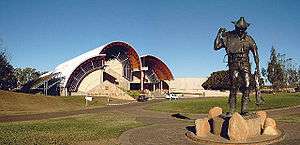
Longreach is the home of the Australian Stockman's Hall of Fame, which was officially opened in 1988 by Queen Elizabeth II. The purpose of the centre is to showcase the history and the culture of life in rural Australia. Since its opening, over 1 million people have passed through its doors.
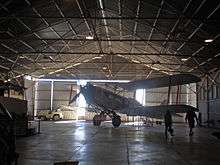
Longreach was one of the founding centres for Qantas, the Australian domestic and international airline, the third oldest airline in the world (after KLM and Avianca), being founded on 16 November 1920 in Winton.[41] One of the airline's original hangars remains in use at the Longreach Airport and is listed on the Australian National Heritage List. The town is now the home of the Qantas Founders Outback Museum, which includes amongst its displays a decommissioned Qantas Boeing 747-200 aircraft, registration VH-EBQ, The City of Bunbury, and Qantas's first jet aircraft VH-XBA (formerly VH-EBA), a Boeing 707, The City of Canberra. In recognition of the town's place in company history, as well as a play on the airliner's extended range, all of Qantas's Boeing 747-400s have "Longreach" printed on both sides of the first jetway entry/exit doors.
The town is home to the Australian Agricultural College's Longreach Campus, which prepares students for work in the agricultural and pastoral industries. It was known previously as the Longreach Pastoral College. The campus was opened in 1967. Adjacent to the college is the Longreach School of Distance Education, which provides lessons to remote students, formerly by HF radio but now using telephone lines. The agricultural college in Longreach closed December 2019.[42]
Notable residents
Notable residents of Longreach include:
- Carl Barron, stand-up comedian, born in Longreach
- Lobby Loyde, guitarist in the Purple Hearts and Coloured Balls, born in Longreach
- Bruce Saunders, Member of the Queensland Legislative Assembly, born in Longreach
- Matthew Scott, rugby league footballer, born in Longreach
- Edgar Towner, Victoria Cross winner, died in Longreach and was buried in the cemetery there. His grave is a protected place.
Climate
| Longreach | ||||||||||||||||||||||||||||||||||||||||||||||||||||||||||||
|---|---|---|---|---|---|---|---|---|---|---|---|---|---|---|---|---|---|---|---|---|---|---|---|---|---|---|---|---|---|---|---|---|---|---|---|---|---|---|---|---|---|---|---|---|---|---|---|---|---|---|---|---|---|---|---|---|---|---|---|---|
| Climate chart (explanation) | ||||||||||||||||||||||||||||||||||||||||||||||||||||||||||||
| ||||||||||||||||||||||||||||||||||||||||||||||||||||||||||||
| ||||||||||||||||||||||||||||||||||||||||||||||||||||||||||||
| Climate data for Longreach | |||||||||||||
|---|---|---|---|---|---|---|---|---|---|---|---|---|---|
| Month | Jan | Feb | Mar | Apr | May | Jun | Jul | Aug | Sep | Oct | Nov | Dec | Year |
| Record high °C (°F) | 47.3 (117.1) |
45.5 (113.9) |
43.6 (110.5) |
39.6 (103.3) |
36.5 (97.7) |
34.3 (93.7) |
34.0 (93.2) |
37.5 (99.5) |
41.5 (106.7) |
43.8 (110.8) |
45.8 (114.4) |
46.6 (115.9) |
47.3 (117.1) |
| Average high °C (°F) | 37.1 (98.8) |
35.9 (96.6) |
34.7 (94.5) |
31.6 (88.9) |
27.1 (80.8) |
23.8 (74.8) |
23.6 (74.5) |
26.1 (79.0) |
30.3 (86.5) |
34.0 (93.2) |
36.2 (97.2) |
37.5 (99.5) |
31.5 (88.7) |
| Average low °C (°F) | 23.2 (73.8) |
22.6 (72.7) |
20.4 (68.7) |
16.5 (61.7) |
12.0 (53.6) |
8.3 (46.9) |
7.2 (45.0) |
8.5 (47.3) |
12.6 (54.7) |
17.0 (62.6) |
20.1 (68.2) |
22.3 (72.1) |
15.9 (60.6) |
| Record low °C (°F) | 13.4 (56.1) |
14.5 (58.1) |
8.7 (47.7) |
2.9 (37.2) |
0.5 (32.9) |
−1.5 (29.3) |
−2.9 (26.8) |
−0.9 (30.4) |
2.0 (35.6) |
4.2 (39.6) |
9.3 (48.7) |
11.8 (53.2) |
−2.9 (26.8) |
| Average rainfall mm (inches) | 77.3 (3.04) |
77.1 (3.04) |
54.4 (2.14) |
34.3 (1.35) |
24.4 (0.96) |
18.8 (0.74) |
18.6 (0.73) |
10.9 (0.43) |
11.9 (0.47) |
22.5 (0.89) |
29.2 (1.15) |
54.5 (2.15) |
433.9 (17.09) |
| Source: BOM[44] | |||||||||||||
References
- Australian Bureau of Statistics (27 June 2017). "Longreach (SSC)". 2016 Census QuickStats. Retrieved 20 October 2018.

- "Longreach - town in Longreach Region (entry 20044)". Queensland Place Names. Queensland Government. Retrieved 11 June 2019.
- "Longreach - locality in Longreach Region (entry 49510)". Queensland Place Names. Queensland Government. Retrieved 11 June 2019.
- "Queensland Globe". State of Queensland. Retrieved 29 July 2019.
- "Where the streets have bird names". ABC Western Queensland. Australian Broadcasting Corporation. 22 February 2013. Archived from the original on 14 April 2018. Retrieved 14 April 2018.
- "Iningai". State Library of Queensland. Retrieved 15 January 2020.
-

- "Celebrating 125 years of Longreach". Queensland State Archives. 9 September 2016. Archived from the original on 11 February 2020. Retrieved 25 March 2020.
- Premier Postal History. "Post Office List". Premier Postal Auctions. Archived from the original on 15 May 2014. Retrieved 10 May 2014.
- Kerr, John (1990). Triumph of narrow gauge : a history of Queensland Railways. Boolarong Publications. p. 224. ISBN 978-0-86439-102-5.
- "Longreach SS". Archived from the original on 4 February 2017. Retrieved 1 February 2017.
- "History". Our Ladies' School. Archived from the original on 29 July 2019. Retrieved 29 July 2019.
- "COMINO BROS". The Longreach Leader. Queensland, Australia. 4 December 1935. p. 21 (THE LONGREACH LEADER). Retrieved 5 February 2020 – via Trove.
- "Greek cafés: a specialty in Queensland's central west | John Oxley Library". Retrieved 5 February 2020.
- "Longreach SHS". Archived from the original on 4 February 2017. Retrieved 1 February 2017.
- "Opening and closing dates of Queensland Schools". Queensland Government. Retrieved 28 July 2019.
- "Evesham school's $250K upgrade on hold". ABC News. Australian Broadcasting Corporation. 3 September 2009. Archived from the original on 29 July 2019. Retrieved 29 July 2019.
- "Longreach School of Distance Education". Archived from the original on 4 February 2017. Retrieved 1 February 2017.
- "Opening and closing dates of Queensland Schools". Queensland Government. Retrieved 18 April 2019.
- "Millions of locusts swarm Central Queensland town of Longreach". The Courier-Mail website. News Limited. 6 April 2010. Archived from the original on 2 March 2012. Retrieved 16 May 2010.
- "Locust plague prompts fears for crops". ABC News website. ABC. 8 April 2010. Retrieved 16 May 2010.
- Australian Bureau of Statistics (31 October 2012). "Longreach (Urban Centre)". 2011 Census QuickStats. Retrieved 9 September 2014.
- "Recent place name decisions: Job number 17-050: Longreach". Queensland Government. Archived from the original on 29 July 2019. Retrieved 29 July 2019.CS1 maint: unfit url (link)
- "Queensland Globe". State of Queensland. Retrieved 28 July 2019.
- "Longreach Railway Station (entry 601970)". Queensland Heritage Register. Queensland Heritage Council. Retrieved 10 July 2013.
- "QATB Centre (former) (entry 600663)". Queensland Heritage Register. Queensland Heritage Council. Retrieved 10 July 2013.
- "Qantas Museum/Former Qantas Hangar (entry 600664)". Queensland Heritage Register. Queensland Heritage Council. Retrieved 10 July 2013.
- "Darr River Downs (entry 600666)". Queensland Heritage Register. Queensland Heritage Council. Retrieved 10 July 2013.
- "Longreach Powerhouse (former) (entry 601541)". Queensland Heritage Register. Queensland Heritage Council. Retrieved 10 July 2013.
- "Powerhouse Museum Longreach". Archived from the original on 17 October 2017. Retrieved 1 February 2017.
- "Longreach Library". Public Libraries Connect. State Library of Queensland. 18 August 2014. Archived from the original on 24 January 2018. Retrieved 24 January 2018.
- "Branch locations". Queensland Country Women's Association. Archived from the original on 26 December 2018. Retrieved 26 December 2018.
- "State and non-state school details". Queensland Government. 9 July 2018. Archived from the original on 21 November 2018. Retrieved 21 November 2018.
- "Longreach State School". Archived from the original on 20 April 2013. Retrieved 21 November 2018.
- "ACARA School Profile 2017". Archived from the original on 22 November 2018. Retrieved 22 November 2018.
- "Longreach State High School". Archived from the original on 22 October 2019. Retrieved 21 November 2018.
- "Longreach School of Distance Education". Archived from the original on 2 May 2012. Retrieved 21 November 2018.
- "Longreach SS - Special Education Program". Archived from the original on 20 April 2013. Retrieved 21 November 2018.
- "Our Lady's Catholic Primary School". Archived from the original on 30 October 2009. Retrieved 21 November 2018.
- "Longreach Leader". Archived from the original on 4 February 2017. Retrieved 1 February 2017.
- "Oldest Airlines In The World That Are Still Operating". World Atlas. Archived from the original on 14 July 2018. Retrieved 24 November 2018.
- "ABC News". 18 October 2019. Archived from the original on 28 November 2019. Retrieved 5 February 2020.
- "Climate statistics for Australian locations - Longreach Aero (records began in 1949)". BOM. Archived from the original on 14 July 2010. Retrieved 16 May 2010.
- "Climate statistics for Australian locations - Longreach Aero (records began in 1949)". BOM. Archived from the original on 21 September 2018. Retrieved 21 September 2018.
Further reading
- Mims, Jeanne M; Queensland Country Women's Association. Morella Branch (1992), Morella memories : a local history, Q.C.W.A. Morella Branch, ISBN 978-0-646-11367-8
External links
![]()
- Maps showing the locality of Longreach before and after the January 2019 amalgamations (archived before and after on 28 July 2019)
| Authority control |
|
|---|