Tambo, Queensland
Tambo is a rural town and locality in the Blackall-Tambo Region, Queensland, Australia.[2][3] In the 2016 census, Tambo had a population of 367 people.[1] Cattle and tourism are the major industries of the town. A number of heritage buildings survive from the earliest days of settlement.
| Tambo Queensland | |||||||||||||||
|---|---|---|---|---|---|---|---|---|---|---|---|---|---|---|---|
 Arthur Street, Tambo | |||||||||||||||
 Tambo | |||||||||||||||
| Coordinates | 24.8844°S 146.2530°E | ||||||||||||||
| Population | 367 (2016 census)[1] | ||||||||||||||
| • Density | 0.5939/km2 (1.5383/sq mi) | ||||||||||||||
| Established | 1863 | ||||||||||||||
| Postcode(s) | 4478 | ||||||||||||||
| Elevation | 395 m (1,296 ft) | ||||||||||||||
| Area | 617.9 km2 (238.6 sq mi) | ||||||||||||||
| Time zone | AEST (UTC+10:00) | ||||||||||||||
| Location |
| ||||||||||||||
| LGA(s) | Blackall-Tambo Region | ||||||||||||||
| State electorate(s) | Gregory | ||||||||||||||
| Federal Division(s) | Maranoa | ||||||||||||||
| |||||||||||||||
| |||||||||||||||
Geography
Tambo is in Central West Queensland, Australia, on the banks of the iland river. Tambo is 101 kilometres (63 mi) southeast of the town of Blackall via the Landsborough Highway, and approximately 862 kilometres (536 mi) north west of the state capital, Brisbane.
The Barcoo River runs through the town and sits near the Grey Range – part of the "Roof of Queensland" section of the Great Dividing Range.
The Landsborough Highway—part of the National Highway network linking Brisbane and Darwin—passes through Tambo. Tambo is also connected to Alpha by the Dawson Development Road.
The Carnarvon National Park (Salvator Rosa section) lies to the east of the town.
History
Indigenous
The area on which the town of Tambo now sits was home of many different Aboriginal groups including the Wadjaling, Wadjalad, Wadjabangai, and Pitjara.
19th century
The first European exploration of the district was by Sir Thomas Mitchell, popularly known as "Major Mitchell", in 1846. For approximately the next 15 years the area was unused until selectors began taking land in 1861.[4]
The town of Carrangarr was founded in 1863, making it the oldest town in western Queensland. Like much of the west, sheep became the mainstay of the economy.[4] The settlement was renamed Tambo in 1868.
The name Tambo comes from an Indigenous Australian word, meaning hidden place,[5] or "resting place, fish, shady waters, hidden waters, a secluded spot, hidden place and native yam."[6]
A branch of the Queensland National Bank was first established in 1875.[7]
Tambo State School opened on 28 February 1876.[8]
20th century
Tambo was the location of Qantas' first fatal accident.[9] An Airco DH.9 crashed on 24 March 1927 with the loss of three lives after the plane stalled while landing.[9]
21st century
In the 2006 census, Tambo had a population of 345, a small decline from the 2001 census population of 357.[10][11] Around 7% of the population of Tambo identity as Aboriginal or Torres Strait Islander and around 6% were born outside Australia.[10]
Tambo was cut off for eight days during the 2010-2011 Queensland floods.[12]
Climate
Temperatures in Tambo range from 35 °C in summer to 21 °C in winter. Minimum temperatures in winter often drop below freezing. The average annual rainfall is 535.7 mm (21.0 in), the majority of which falls between December and March.
| Climate data for Tambo (Tambo Post Office 1957–2013) | |||||||||||||
|---|---|---|---|---|---|---|---|---|---|---|---|---|---|
| Month | Jan | Feb | Mar | Apr | May | Jun | Jul | Aug | Sep | Oct | Nov | Dec | Year |
| Record high °C (°F) | 44.2 (111.6) |
42.8 (109.0) |
40.5 (104.9) |
37.1 (98.8) |
34.4 (93.9) |
31.7 (89.1) |
30.0 (86.0) |
35.0 (95.0) |
39.0 (102.2) |
41.0 (105.8) |
43.3 (109.9) |
43.3 (109.9) |
44.2 (111.6) |
| Average high °C (°F) | 34.9 (94.8) |
33.8 (92.8) |
32.4 (90.3) |
29.1 (84.4) |
24.9 (76.8) |
21.6 (70.9) |
21.2 (70.2) |
23.5 (74.3) |
27.3 (81.1) |
30.9 (87.6) |
33.2 (91.8) |
34.8 (94.6) |
29.0 (84.2) |
| Average low °C (°F) | 20.4 (68.7) |
20.0 (68.0) |
17.5 (63.5) |
12.7 (54.9) |
8.1 (46.6) |
4.9 (40.8) |
3.6 (38.5) |
5.1 (41.2) |
9.0 (48.2) |
13.7 (56.7) |
17.0 (62.6) |
19.1 (66.4) |
12.6 (54.7) |
| Record low °C (°F) | 10.4 (50.7) |
9.5 (49.1) |
5.8 (42.4) |
0.0 (32.0) |
−3.0 (26.6) |
−5.0 (23.0) |
−5.6 (21.9) |
−5.6 (21.9) |
−2.5 (27.5) |
−0.5 (31.1) |
4.4 (39.9) |
7.0 (44.6) |
−5.6 (21.9) |
| Average rainfall mm (inches) | 81.0 (3.19) |
77.5 (3.05) |
58.3 (2.30) |
37.1 (1.46) |
34.4 (1.35) |
28.6 (1.13) |
27.1 (1.07) |
18.7 (0.74) |
21.3 (0.84) |
34.6 (1.36) |
47.0 (1.85) |
70.1 (2.76) |
535.7 (21.1) |
| Average rainy days (≥ 0.2mm) | 7.6 | 6.8 | 5.7 | 3.3 | 3.3 | 3.3 | 3.0 | 2.5 | 3.1 | 4.7 | 5.7 | 6.7 | 55.7 |
| Source: Bureau of Meteorology[13] | |||||||||||||
Heritage
The "Tambo Heritage Trail" includes 17 buildings within the town's precinct of historical importance. They include:
- Post and Telegraph office building
- Reg Barry's Memorial
- Survey Marker
- Old Tambo Post Office (1876)
- Courthouse (1888)
- Tambo Shire Hall
- Masonic Lodge
- Old Powerhouse
- Tambo State School
- Windmill at Tambo Mill Motel
- Primary Health Care
- The Club Hotel
- General Store
- Royal Carrangarra Hotel
- Tambo Teddies Workshop
- Queensland National Bank
 Tambo Educational Academy. 1905
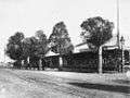 Volk's Club Hotel, circa 1912
 The Club Hotel, 2012
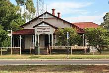 Tambo Public Library, previously Tambo Courthouse. Built in 1888
 Tambo Post Office, built 1904
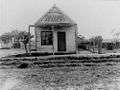
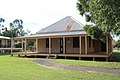 Tambo Post and Telegraph Office. Built 1876
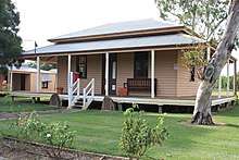 Tambo Electronic Telegraph Office. Built 1885
 Reg Barry's Memorial
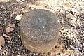 Tambo Survey Marker
 Tambo Shire Hall
 Tambo Windmill
 Royal Carrangarra Hotel
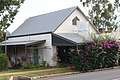 Tambo Teddies Workshop
 Teddy Crossing Tambo
Heritage listings
Tambo has a number of heritage-listed sites, including:
- Arthur Street: former Tambo Post Office[14]
- 9 Arthur Street: former Tambo Court House[15]
Economy
The chief industries of the town and district are grazing properties for sheep and cattle. There was a sawmill which closed in 2011.[16] The sawmill reopened March 2018.[17][18][19][20]
Amenities and attractions

The heritage-listed former Courthouse in Arthur Street contains the Tambo Visitor Information Centre and the Tambo Library.[21] The Courthouse was built in 1888.[22]
Tambo is also famous for its Tambo Teddy Workshop, set up by 3 local women in 1992 to help promote the wool industry after years of drought had cause wool prices to fall.[23] One of these teddies was given to Prince Harry and his wife Meghan. (The Duke and Duchess of Sussex) when they visited Australia. There have been numerous commercials advertising the teddies, along with these facts.
The Tambo branch of the Queensland Country Women's Association meets at the Royal Carrangarra Hotel in Arthur Street.[24]
Tambo State School opened on 28 February 1876 and caters for students in years P-10.[25][26] Distance education services are provided for students in years 11 and 12.[27]
Governance
Until 2008, Tambo was the administrative centre of the Shire of Tambo. In 2008, as part of the Queensland Government's amalgamation of local government areas, the Shire of Tambo was abolished and Tambo is now a part of the Blackall-Tambo Region.[28]
References
- Australian Bureau of Statistics (27 June 2017). "Tambo (SSC)". 2016 Census QuickStats. Retrieved 20 October 2018.

- "Tambo - town in Blackall-Tambo Region (entry 33227)". Queensland Place Names. Queensland Government. Retrieved 15 November 2019.
- "Tambo - locality in Blackall-Tambo Region (entry 47066)". Queensland Place Names. Queensland Government. Retrieved 15 November 2019.
- "Post Office, Tambo". University of Queensland. Archived from the original on 8 August 2014. Retrieved 13 March 2012.
- "What's in a name? – 3. Australia's Centenary of Federation". Australian Broadcasting Corporation. 31 October 2001. Archived from the original on 8 January 2014. Retrieved 13 February 2012.
- L'Estrange (1996), p. 21.
- "TAMBO (QUEENSLAND)". Australian Town and Country Journal. NSW. 4 December 1875. p. 6. Retrieved 13 March 2012 – via National Library of Australia.
- Queensland Family History Society (2010), Queensland schools past and present (Version 1.01 ed.), Queensland Family History Society, ISBN 978-1-921171-26-0
- Gunn, John (1985). The Defeat of Distance: QANTAS 1919 – 1939. Brisbane, Australia: University of Queensland Press. p. 96. ISBN 0702217077. Retrieved 13 March 2012.
- Australian Bureau of Statistics (25 October 2007). "Tambo (L) (Urban Centre/Locality)". 2006 Census QuickStats. Retrieved 25 July 2009.
- Australian Bureau of Statistics (9 March 2006). "Tambo (L) (Urban Centre/Locality)". 2001 Census QuickStats. Retrieved 13 March 2012.
- Ball, Chris. "Flood recovery in Western Queensland – Tambo – their stories". ABC Western Queensland. Archived from the original on 3 March 2016. Retrieved 13 March 2012.
- "Tambo Post Office". Climate statistics for Australian locations. Bureau of Meteorology. March 2013. Retrieved 3 April 2013.
- "Tambo Post Office (former) (entry 600833)". Queensland Heritage Register. Queensland Heritage Council. Retrieved 7 July 2013.
- "Tambo Court House (former) (entry 600834)". Queensland Heritage Register. Queensland Heritage Council. Retrieved 7 July 2013.
- Cripps, Sally (25 August 2016). "Sawmill re-growing Tambo". Queensland Country Life. Archived from the original on 16 March 2020. Retrieved 16 March 2020.
- "Blackall-Tambo Regional Council - A modern rural community". Business View Oceania. 15 November 2016. Archived from the original on 16 March 2020. Retrieved 16 March 2020.
- Cripps, Sally (22 August 2017). "Sawdust in the air at Tambo". Queensland Country Life. Archived from the original on 16 March 2020. Retrieved 16 March 2020.
- Dick, Cameron (28 April 2018). "Sawmill reopening leads Tambo's revival - The Queensland Cabinet and Ministerial Directory". Media Statements. Queensland Government. Archived from the original on 16 March 2020. Retrieved 16 March 2020.
- "Queensland sawmill opens after 7-year shut down". WoodTECH. Archived from the original on 16 March 2020. Retrieved 16 March 2020.
- "Tambo Library". Public Libraries Connect. State Library of Queensland. 7 August 2014. Archived from the original on 6 February 2018. Retrieved 6 February 2018.
- "Blackall-Tambo Regional Council Tambo Visitor Information Centre". Archived from the original on 12 March 2012.
- Melanie Groves (2 February 2018). "Tambo Teddies celebrate 25 years of a business created for hard times". abc.net.au. Australian Broadcasting Corporation. Archived from the original on 24 March 2019. Retrieved 24 March 2019.
- "Branch locations". Queensland Country Women's Association. Archived from the original on 26 December 2018. Retrieved 26 December 2018.
- "Opening and closing dates of Queensland Schools". Queensland Government. Retrieved 18 April 2019.
- "Tambo State School". Education Queensland. Archived from the original on 4 February 2017. Retrieved 2 February 2017.
- "Tambo Schools". Blackall-Tambo Regional Council. Archived from the original on 27 March 2012. Retrieved 13 March 2012.
- "Tambo and Tambo Shire". Queensland Places. Centre for the Government of Queensland. Archived from the original on 22 October 2012. Retrieved 13 March 2012.
Bibliography
- L'Estrange, Jan (1996). Belle of the Barcoo: Tambo – genesis of Queensland's Central West. Harrison Printing. ISBN 0646288938.
External links
| Wikimedia Commons has media related to Tambo, Queensland. |
| Authority control |
|
|---|