Kumaon division
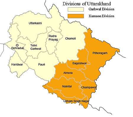
Kumaon or Kumaun is one of the two regions and administrative divisions of the Indian state of Uttarakhand, the other being Garhwal. It includes the districts of Almora, Bageshwar, Champawat, Nainital, Pithoragarh, and Udham Singh Nagar. It is bounded on the north by Tibet, on the east by Nepal, on the south by the state of Uttar Pradesh, and on the west by the Garhwal region. The people of Kumaon are known as Kumaonis and speak the Kumaoni language.
Historically ruled by the Multiple Hindu Dynasties, the Kumaon division was formed in 1816, when the British reclaimed this region from the Gorkhas, who had annexed the erstwhile Kingdom of Kumaon in 1790. The division initially consisted of three districts, Kumaon, Terai and Garhwal, and formed the northernmost frontier of the Ceded and Conquered Provinces in British India, that later became North Western Provinces in 1836, United Provinces of Agra and Oudh in 1902, and United Provinces in 1937.
It is home to a famous Indian Army regiment, the Kumaon Regiment. Important Towns of Kumaon are Nainital, Almora, Pithoragarh, Champawat, Bageshwar, Mukteshwar and Ranikhet. Nainital is the administrative centre of Kumaon Division and this is where the Uttarakhand high court is located.[1]
Etymology
Kumaon is believed to have been derived from Kurmanchal, meaning land of the Kurmavatar (the tortoise incarnation of Lord Vishnu, the preserver according to Hinduism). The region of Kumaon is named after as such.[2][3]
During the time of the British control of the region, between 1815 and 1857 it was also known as Kemaon.[4][5][6]
Geography

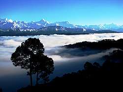
The Kumaon[7] region consists of a large Himalayan tract, together with two submontane strips called the Terai and the Bhabar. The submontane strips were up to 1850 an almost impenetrable forest, given up to wild animals; but after 1850 the numerous clearings attracted a large population from the hills, who cultivated the rich soil during the hot and cold seasons, returning to the hills in the rains. The rest of Kumaon is a maze of mountains, part of the Himalaya range, some of which are among the loftiest known. In a tract not more than 225 km in length and 65 km in breadth there are over thirty peaks rising to elevations exceeding 5500 m.[8]
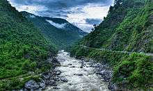
The rivers like Gori, Dhauli, and Kali rise chiefly in the southern slope of the Tibetan watershed north of the loftiest peaks, amongst which they make their way down valleys of rapid declivity and extraordinary depth. The principal is the Sharda (Kali Ganga), the Pindari and Kailganga, whose waters join the Alaknanda.[8] The river Sharda (Kali Ganga) forms the international boundary between India and Nepal. The pilgrim route currently used to visit Kailash-Mansarovar goes along this river and crosses into Tibet at Lipu Lekh pass.
The chief trees are the Chir Pine, Himalayan Cypress, Pindrow Fir, Alder, Sal and Saindan. Limestone, sandstone, slate, gneiss and granite constitute the principal geological formations. Mines of iron, copper, gypsum, lead and asbestos exist; but they are not thoroughly worked. Except in the submontane strips and deep valleys, the climate is mild. The rainfall of the outer Himalayan range, which is first struck by the monsoon, is double that of the central hills, in the average proportion of 2000 mm to 1000 mm. No winter passes without snow on the higher ridges, and in some years, it is universal throughout the mountain tract. Frosts, especially in the valleys, are often severe.[8]
History
Prehistoric dwellings and Stone Age implements have been discovered in Almora and Nainital districts. Initially settled by Kol tribals, the region witnessed successive waves of Kiratas, Khasas and Indo-Scythians. Kunindas were the first rulers of the region. The were followed by the Katyuri kings who controlled the region from 700 –1200 AD.[2]
Around 1100-1200 AD after Katyuri kingdom disintegration Kurmanchal was divided into eight different principalities: Baijnath-Katyur, Dwarhat, Doti, Baramandal, Askot, Sira, Sora, Sui (Kali kumaon). Around 1581 AD, under Rudra Chand, the whole region was brought together again as Kumaon.
Kumaon Kingdom
Katyuri Raj
The Katyuri dynasty was of a branch of Kunindas origin and was founded by Vashudev Katyuri. they established their kingdom and called it Kurmanchal kingdom, they dominated lands of varying extent from the 'Katyur' (modern day Baijnath) valley in Kumaon, between 7th and 11th centuries AD, and established their capital at Baijnath in Bageshwar district, which was then known as Kartikeyapura and lies in the centre of 'Katyur' valley. Brahmadev mandi in Kanchanpur District of far western Nepal was established by Katyuri king Brahma Deo.
At their peak, the kurmanchal kingdom of katyuri kings was extended from Sikkim in the east to Kabul, Afghanistan in the west, before fragmenting into numerous principalities by the 12th century. They were displaced by the Chand Kings in the 11th century AD. Architectural remains of the Katyur dynasty's rule can be found in Baijnath and Dwarahat.
The Rajbar dynasty of Askot in Pithoragarh, was set up in 1279 AD, by a branch of the Katyuri Kings, headed by Abhay Pal Deo, who was the grandson of Katyuri king, Brahma Deo . The dynasty ruled the region till it became part of the British Raj through the treaty of Sighauli in 1816.
Chand Raj
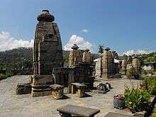
The Chand dynasty was established by Som Chand in the 10th century,[9] by displacing the Katyuri Kings,who had been ruling the area from the 7th century AD. He continued to call his state Kurmanchal and established its capital in Champawat in Kali Kumaon called so, due to its vicinity to river Kali. Many temples built in this former capital city, during the 11th and 12th century exist today, this includes the Baleshwar and Nagnath temples.
One of most powerful rulers of Chand dynasty was Baz Bahadur (1638–78) AD, who met Shahjahan in Delhi, and in 1655 joined forces with him to attack Garhwal, which was then under the King Pirthi Sah. Baz Bahadur subsequently captured the Terai region including Dehradun, which was thus separated from the Garhwal kingdom. Baz Bahadur extended his territory east to Karnali river. In 1672, Baz Bahadur started a poll tax, and its revenue was sent to Delhi as a tribute. Baz Bahadur also built the Golu Devata Temple, at Ghorakhal, near Bhimtal,[9] after Lord Golu, a general in his army, who died valiantly in battle.[10] He also built the famous Bhimeshwara Mahadev Temple at Bhimtal.[11]
Towards the end of the 17th century, Chand kings again attacked the Garhwal kingdom, and in 1688, Udyot Chand erected several temples at Almora, including Tripur Sundari, Udyot Chandeshwar, and Parbateshwar. To mark his victory over Garhwal and Doti, the Parbateshwar temple was renamed twice, to become the present Nanda Devi temple.[12] Later, Jagat Chand (1708–20), defeated the Raja of Garhwal and pushed him away from Srinagar (in Uttarakhand, not to be confused with the capital of present-day Indian Kashmir), and his kingdom was given to a Brahmin.[13] However, a subsequent king of Garhwal, Pradip Shah (1717–72), regained control over Garhwal and retained Dehra Dun till 1757, when Rohilla leader, Najib-ul-Daula, established himself there, though he was ousted soon by Pradip Shah.
Raikas Of Doti
Niranjan Malldeo was the founder of Doti Kingdom around the 13th century after a fall of Katyuris Kingdom. He was the son of Last Katyuris of united Katyuris kingdom. Kings of Doti were known as Raikas. Later on Raikas, after overthrow Khas Malla of Karnali Zone, were able to form a strong Raikas Kingdom in Far Western Region and Kumaon which was called Doti. So far, the historical evidence of following Raikas have been discovered; Niranjan Malldev (Founder of Doti Kingdom), Nagi Malla (1238 AD), Ripu Malla (1279 AD), Nirai Pal (1353 AD may be of Askot and his historical evidence of 1354 A.D has been found in Almoda), Nag Malla (1384 AD), Dhir Malla (1400 AD), Ripu Malla (1410 AD), Anand Malla (1430 AD), Balinarayan Malla (not known), Sansar Malla (1442 AD), Kalyan Malla (1443 AD), Suratan Malla (1478 AD), Kriti Malla(1482 AD), Prithivi Malla (1488 AD), Medini Jay Malla (1512 AD), Ashok Malla (1517 AD), Raj Malla (1539 AD), Arjun Malla/Shahi (not known but he was ruling Sira as Malla and Doti as Shahi), Bhupati Malla/Shahi (1558 AD), Sagaram Shahi (1567 AD), Hari Malla/Shahi (1581 AD Last Raikas King of Sira and adjoining part of Nepal ), Rudra Shahi (1630 AD), Vikram shahi (1642 AD), Mandhat shahi (1671 AD), Raghunath shahi (1690 AD), Hari shahi (1720 AD), Krishna Shahi (1760 AD), Deep shahi (1785 AD), Prithivi pati Shahi (1790 AD, 'he had fought several wars against British & Gokha attack on Doti Kingdom. The Kingdom finally defeated and became a part of Gorkha the present Nepal in 1814 AD')[14]
Nepalese invasion and its defeat
In the latter half of the 18th century, the power of Kumaon was on decline, as the king Mahendra Chand was unable to properly administer the country. After the fall of Doti, the Gorkhas decided to invade over Kumaon. The Gorkha forces, under the leadership of Amar Singh Thapa crossed the kali river, and reached Almora via Sor and Gangoli. Mahendra Chand fled to the plains, and Kumaon was easily annexed to the Gorkha Kingdom.
The Gorkha rule over Kumaon lasted for 24 years, and has been termed as "Cruel and Oppressive" in a number of texts. The only architectural advancements during the period was a road connecting kali river to Srinagar via Almora. Almora was the largest town of Kumaon during the gorkha period, and is estimated to have about 1000 houses.
After the Gorkhas started meddling in the territories of Oudh, the Nawab of Oudh, who was then a suzerain of the British Empire, asked for their help, thus paving way for the Anglo-Nepalese War of 1814. The British forces under Colonel Nicholas, consisting of about forty five hundred men and six ponder guns, entered Kumaon through Kashipur and conquered Almora on 26 April 1815. On the same day, Chandra Bahadur Shah, one of the principle Gurkha chiefs, sent a flag of truce, requesting to end hostilities in the region. A negotiation was brought up the following day, under which the Gurkhas agreed to leave the Country, and all its fortified places. The war ended with Nepal signing the Treaty of Sugauli in 1816, under which, Kumaon officially became a British territory.
British Raj
Later, the region was annexed by the British. In 1815 the Kumaon region was joined with the eastern half of the Garhwal region as a chief-commissionership on the non-regulation system, also known as the Kumaon Province.[15] It was governed for seventy years by three administrators, Mr. Traill, Mr. J. H. Batten and Sir Henry Ramsay.
There was widespread opposition against British rule in various parts of Kumaon. The Kumaoni people especially Champawat District rose in rebellion against the British during the Indian Rebellion of 1857 under the leadership of the members like Kalu Singh Mahara.[16] In 1891 the division was composed of the three districts of Kumaon, Garhwal and the Tarai; but the two districts of Kumaon and the Tarai were subsequently redistributed and renamed after their headquarters, Nainital and Almora.
The area received international attention after the publication of Man-Eaters of Kumaon, by Jim Corbett, the noted hunter and conservationist, describing the author's trials seeking out and killing man-eating tigers. Animals like the Champawat Tiger and the Chowgarh Tigers plagued the area for many years, with the former estimated to have killed over four hundred humans by herself, in Nepal and then Kumaon, in the years 1920-28.
Mahatma Gandhi's advent sounded a death knell for the British in Kumaon. People now aware of the excesses of British Raj became defiant of it and played an active part in the Indian Struggle for Independence. While staying in Kumaon for 12 days, recovering from the rigors of imprisonment, Gandhi wrote Anashakti Yoga, his commentary on the Gita.[17]
In these hills, nature's hospitality eclipses all men can do. The enchanting beauty of Himalayas, their bracing climate and the soothing green that envelopes you leaves nothing more to be desired. I wonder whether the scenery of these hills and the climate are surpassed, if equaled, by any of the beauty spots anywhere of the world. After having been nearly three weeks in Almora hills, I am more than ever amazed why our people need go to Europe in search of health.
Gandhi was revered in these parts and on his call the struggle of Salam Saliya Satyagraha led by Ram Singh Dhoni was started which shook the very roots of British rule in Kumaon.[19] Many people lost their lives in the Saalam Satyagraha due to police brutality. Gandhi named it the Bardoli of Kumaon an allusion to the Bardoli Satyagrah Many Kumaonis also joined the Indian National Army led by Netaji Subhash Chandra Bose.
Independent India
After India became independent in 1947, United Provinces were converted into the newly formed Indian state of Uttar Pradesh. The princely state of Tehri Garhwal joined the Indian Union in 1949, and became a district under the Kumaon division. Three new districts viz. Pithoragarh from Almora, Chamoli from Garhwal and Uttarkashi from Tehri Garhwal were created in 1960. A new revenue division, named Uttarakhand division was carved out from these 3 districts of Kumaon division.
The year 1969 saw major administrative reforms in these hilly regions of Uttar Pradesh, and a new Garhwal division, with its headquarter in Pauri, was formed with the districts of Tehri Garhwal and Garhwal from Kumaon division, and Uttarkashi and Chamoli from Uttarkhand division. The Uttarakhand division too was disestablished the same year, and the remaining district of Pithoragarh was brought back to Kumaon division, hence giving it its present size.
Three new districts were created in the 90's, taking the total number of districts in the division to 6. Udham singh nagar from Nainital in 1995, and Bageshwar from Almora and Champawat from Pithoragarh in 1997. Two new districts, Ranikhet from Almora and Didihat from Pithoragarh were announced in 2011 by the then Chief minister of Uttrakhand, Ramesh Pokhriyal, but the districts never came into existence because no official notification was ever released.
Languages
The main language used in administration and education is Hindi, which according to the 2011 census is the first language of well over a million of the region's inhabitants (mostly concentrated in the south). The major native language, however, is Kumaoni, spoken by about 2 million people. In the southern districts there are also sizeable numbers of speakers of Punjabi, Urdu and Bengali,[20] while the two related languages of Buksa and Rana Tharu are found in the southernmost Udham Singh Nagar district. The higher mountains in the north of Kumaon are home to the Sino-Tibetan Byangsi, Chaudangsi, Darmiya, Raji, Rawat and Rangas (the last now extinct).[21]
The community radion station Kumaon Vani has been broadcasting over the region since 2010.[22]
See also
- Kumaoni people
- List of Kumaonis
- Man-Eaters of Kumaon – a book
- Chand kings
- Martial race
- Garhwal division
- Iris kumaonensis (Iris from the region)
- Kumaoni language
Further reading
- Kak, Manju (2017). In the Shadow of the Devi Kumaon: Of a Land, a People, a Craft. Niyogi Books.
- Upreti, Ganga Dutt (1894). Proverbs & folklore of Kumaon and Garhwal. Lodiana Mission Press.
- Oakley, E Sherman (1905). Holy Himalaya; the religion, traditions, and scenery of Himalayan province (Kumaon and Garwhal). Oliphant Anderson & Ferrier, London.
- Raja Rudradeva of Kumaon (1910). Haraprasada Shastri (ed.). Syanika sastra: or A Book on Hawking. Asiatic Society, Calcutta.
References
- Kumaon Information
- Gokhale, Namita (2015). Mountains Echoes: Reminiscences of Kumaoni Women. Roli Books Private Limited. ISBN 978-93-5194-180-4. Retrieved 31 January 2020.
- Gajrani, S. (2004). History, Religion and Culture of India. Gyan Publishing House. p. 236. ISBN 978-81-8205-064-8. Retrieved 31 January 2020.
- James Prinsep (Editor)Journal of the Asiatic Society of Bengal, Volume 6, Part 2 (1837), p. 653, at Google Books
- John McClelland Some inquiries in the province of Kemaon: relative to geology, and other branches of Natural Science (1835) at Google Books
- John Forbes Royle Illustrations of the botany and other branches of the natural history of the Himalayan Mountains and of the flora of Cashmere (1839), p. 108, at Google Books
- Vacation Places in Kumaon and Garhwal
-

- History of Nainital District. The Imperial Gazetter of India. 1909. p. 324.
- "Chitai Temple". Archived from the original on 13 April 2009. Retrieved 3 October 2016.
- "Bhimtal". Archived from the original on 18 June 2008. Retrieved 3 October 2016.
- "Almora Temples Uttaranchal - Uttarakhand Worldwide - Kumaon and Garhwal - Almora Temples". www.uttaranchal.org.uk. Archived from the original on 4 March 2016. Retrieved 3 October 2016.
- History of Garhwal District. The Imperial Gazetteer of India. 1909. p. 165. Retrieved 3 October 2016.
- The Himalayan gazetteer -Atkinson
- Robert Montgomery Martin, History of the Possessions of the Honourable East India Company, Volume 1, pg. 107
- "The Tribune, Chandigarh, India - Dehradun Edition". Tribuneindia.com. Retrieved 12 July 2012.
- "In Gandhi's footsteps". www.telegraphindia.com. 21 February 2009. Retrieved 8 January 2020.
- Gandhi, M. K. (11 July 1929). "Almora Impressions". Young India: 2. Retrieved 8 January 2020.
- рдореНрдпрд░ рдкрд╣рд╛реЬ on 5 March 2010 (5 March 2010). "Salt Kranti in Uttarakhand: An Important Chapter of Freedom Movement". Merapahad.com. Retrieved 12 July 2012.
- C-16 Population By Mother Tongue – Uttarakhand (Report). Office of the Registrar General & Census Commissioner, India. Retrieved 6 October 2019.
- Eberhard, David M.; Simons, Gary F.; Fennig, Charles D., eds. (2019). "India – Languages". Ethnologue (22nd ed.). SIL International. Archived from the original on 1 April 2019.
- "Kumaon Vani Community Radio - 90.4 MHz". 27 December 2017. Retrieved 16 January 2020.
- A New History of Uttrakhand by Dr. Y. S. Kathoch
External links
| Wikivoyage has a travel guide for Kumaon. |
| Government |
|  | |||||||||||||||
|---|---|---|---|---|---|---|---|---|---|---|---|---|---|---|---|---|---|
| History |
| ||||||||||||||||
| Geography and Ecology |
| ||||||||||||||||
| Demographics |
| ||||||||||||||||
| Administrative divisions |
| ||||||||||||||||
| Politics | |||||||||||||||||
| Tourism |
| ||||||||||||||||
| Sports | |||||||||||||||||
| Other topics | |||||||||||||||||
| Districts |
| ||||||||||||||||
| Major cities | |||||||||||||||||