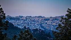
Ranikhet
Ranikhet is a hill station and cantonment town in Almora district[1] in the Indian state of Uttarakhand. It is the home for the Military Hospital, Kumaon Regiment (KRC) and Naga Regiment and is maintained by the Indian Army. Ranikhet is at an altitude of 1,869 metres (6,132 ft)[2] above sea level and within sight of the western peaks of the Himalayas. Ranikhet is a Class IV town with a civic status of a Cantonment board.[3]
Ranikhet रानीखेत Queen's Land | |
|---|---|
Town | |
 | |
| Nickname(s): Ranikhet | |
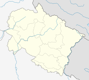 Ranikhet Location in Uttarakhand, India  Ranikhet Ranikhet (India) | |
| Coordinates: 29.65°N 79.42°E | |
| Country | |
| State | Uttarakhand |
| District | Almora |
| Elevation | 1,869 m (6,132 ft) |
| Population (2011) | |
| • Total | 19,049 |
| Languages | |
| • Official | Hindi, Kumaoni, Sanskrit |
| • Native | Kumaoni |
| Time zone | UTC+5:30 (IST) |
| Vehicle registration | UK, 20 |
| Website | uk |
History
Ranikhet, which means Queen's meadow in hindi, gets its name from a local legend, which states that it was here, that Raja Sudhardev won the heart of his queen, Rani Padmini, who subsequently chose the area for her residence, giving it the name, Ranikhet,[4] though no palace exists in the area.
In 1869,[5] the British established the headquarters of the Kumaon Regiment here and used the station as a retreat from the heat of the Indian summer. At one time during British Raj, it was also proposed as the summer headquarters of Government of India, in lieu of Shimla. In 1900, it had a summer population of 7,705, and its corresponding winter population was measured in 1901 as 3,153[6]
Ranikhet had been under Nepalese rule, and the Kumaonis won it under the leadership of their able General Kashi Nath Adhikari – after whom the small town of Kashipur was named (which at one point of time was the gateway to the hills and is now an educational and institutional hub) – with the help of Britishers at around 1816 and is a part of India now.
Geography
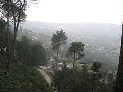
Ranikhet has an average elevation of 1,869 m (6,132 ft). The climate of the town is very cool. The cantonment is spread across two ridges, the first, called the Ranikhet ridge, is situated at an elevation of 5,983 ft (1,824 m) and the second, the Chaubattia ridge, is at an elevation of 6,942 ft (2,116 m).The western narrow strips and eastern part of Ranikhet are comparatively high and covered with a dense forest mainly of pine.[7]
Climate
Ranikhet becomes very cold in the winters and remains moderate in summers, and is best enjoyed from March to October. Ranikhet gets snowfall in the winter season, mainly in the months of December, January and February. But in the rest of the months the weather of Ranikhet remains pleasant.
Flora and fauna
The pine, oak, and deodar forests host an array of wildlife including leopard, leopard cat, mountain goat, barking deer, sambar, yellow throated marten, Indian hare, Rhesus monkey, Dhole, langur, red fox, and porcupine.[8]
Places to visit
Golf Course
Ranikhet Golf Course is one of the highest golf courses of Asia[9], located 5 kilometres (3 mi) from main Ranikhet City. Ranikhet Golf Course is a 9-hole course making it one of the prime attractions of Ranikhet. The green meadow of the golf course at such high altitude is awe-inspiring. The golf club provides membership plans for outsiders as well .Golf course is located in KALIKA.
Ashiyana Park
Ashiyana Park is situated in the midst of Ranikhet town. The Park is specially designed & developed for children on jungle theme by Ranikhet Cantt.
Mankameshwar Temple
This temple is attached to the Nar Singh Maidan (Ground), constructed by the Kumaon regiment. Opposite the temple is a Gurudwara and a Shawl factory.
Rani Jheel
There is another jewel added to the beauty of town "Rani Jheel". Located nearby Nar Singh Stadium, beneath the Veer Naari Awas it gives the visitors a chance to relax and enjoy the ride of Boats.
Binsar Mahadev
The artistic structure of the Binsar Mahadev Temple and its deity Lord Shiva both adds positive vibes to our mind and soul. A beautiful stream flowing close to the Binsar Mahadev Temple adds amazement to the natural beauteousness of this sacred place. Binsar Mahadev Temple is situated amidst beautiful pine and deodar trees. Apart from the temple an ashram, Binsar Mahadev also has lovely cedar forest surroundings.
Babar Khola
Village resembles Scottish countrysides, just few 5 km from Majhkali, is abode to plethora of Flora and Fauna which includes Yellow Throated Marten, Leopard, Himalayan Black Bear etc. Major Garhwal Himalayan ranges are visible which includes peaks such as Nanda Devi Massif, Nanda Ghunti, Trishul Complex, Panchachuli, Mrigthuni, Nanda Kot etc.
Haidakhan Temple
Situated 4 km from Ranikhet, Haidakhan Temple (Hairakhan Temple or Chilianaula) is dedicated to Lord Shiva made by Shri Haidakhan Maharaj who is said to be the incarnation of Lord Shiva.
The splendid views of the gigantic Himalayan peaks are clearly visible from Haidakhan Temple.

Bhalu Dam or Baludham
It is an artificial small lake blessed with natural bounteousness, panoramic views of the Himalayan Mountains and placid surroundings. The small but beautiful garden nearby the dam is marvelous.
The dam site is open for all the tourists throughout the year. The views of the massive Himalayan peaks are enchanting and ravishing from Bhalu Dam. It is an ideal spot for camping and picnicking. St. Bridget's Church is an old church in Ranikhet town.
Majkhali
Located at a distance of 12 km from Ranikhet, on the way to Almora, Majkhali offers a close view of the snowy Himalayas with peaceful surroundings. It also holds 'melas' during festivals and one can witness the true kumaoni culture. It is a picnic spot on the Ranikhet-Almora road. Ashok Hall Girls school and The Pleasant Valley School are located near Majkhali.
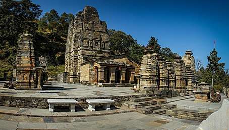
Katarmal (Sun Temple)
It is the second most important temple to Sun God, the first one is Konark Sun Temple in Orissa. Katarmal is more than 800 years old. Situated 25 km from Ranikhet this historical temple is an example of intricate sculpturing.
Tarikhet
Tarikhet is located at a distance of 8 kilometres (5 mi) from Ranikhet is well known for its Gandhi Kuti, and the temple of Golu Devta is venerated in the Kumaon region. It is famous for the Gandhi Kuti and the temple of Golu Devta.
Syalikhet
It is a scenic spot with unparallel beauty situated at a distance of 25 kilometres (16 mi) from Ranikhet. Syalikhet is located in the amidst green forest and apple orchards. The famous temple of Syahi Devi is situated in Syalikhet.
KRC (Kumaon Regimental Centre) Museum
Maintained by the Kumaon Regiment and the Naga Regiment of the Indian Army, the museum has a wide collection ranging from stories of the heroics of the First World War till date. It has on display the various weapons captured, flags of enemies captured by the army and also the LTTE boat captured during Operation Pawan. It has stories of the First and the Second Param Vir Chakra who belonged to the Kumaon Regiment. You can also get to know the list of all the Army Generals who belonged to the Kumaon Regiment. The regiment, which has a long and successful history of heroics and tales of valor, is on full display at the museum. Contributions by the Regiment during the World Wars, during the Indo-China war and the Pakistan war, during Kargil and Op Pawan can be known at this Museum. The Museum is very well maintained by the Army and they also provide an Army guide who will help understand the history and the heroics of the Regiment. Photography is prohibited inside the Museum. Interesting to see are the weapons captured during the war, some of them weigh nearly 80 kg and require at least 2 people to carry and load it. You also get to see the medals and uniforms of the brave soldiers. A visit to this Museum is must when going to Ranikhet. One gets a strong feeling of patriotism when visiting this museum.
Jhula Devi temple
Jhula Devi temple is situated at a distance of 7 kilometres (4 mi) from the town of Ranikhet near Chaubatia. It is said that the dense jungle near the temple was once full of wild animals, leopards and tigers used to attack local villagers. The villagers prayed to Maa Durga for protection, and one day Goddess Durga came in a shepherd's dream and advised him to excavate her idol. This temple was constructed at the spot where the shepherd found Goddess Durga's idol. Since then pilgrims come to make a wish to Goddess Jhula Devi. And when their wish is fulfilled they come again to thank Jhula Devi Maa by offering a bell to the temple. The popularity of the temple can be realized by number of bells hanging over the temple walls. The temple priests have to timely shift the old bells to a different place to make room for the new bells that are tied everyday. In addition to bells, dried coconut and prasad is offered to the Goddess. This place has a calm environment and a sense of spiritual peace to it.
Rama Mandir (temple)

Located in the vicinity of Jhula Devi temple is the Rama Mandir, dedicated to lord Rama. A small flight of stairs goes to the hilltop where the temple is situated. Rama Mandir has a monastery where students are taught ancient vedas along with vedic and modern mathematics in direction of Sant Sri Mouni Maharaj. People who have a keen interest in vedas should not miss the chance to visit this temple.

Chaubatia Gardens
Located about 10 kilometres (6 mi) from Ranikhet, this place has plantation of apricots, peaches, chestnuts, and almonds and is famous for apple orchards. With a wide variety of Himalayan flora, it also offers the picturesque views of snowcapped Himalayas. Apart from fruits, one can buy fresh juices and artisan honey from the garden store on the way out.


Demographics
The Cantonment Town of Ranikhet has a population of 19,049 persons. 16271 persons in Ranikhet are literates (10206 Male and 6065 Female).[10] The literacy rate in Ranikhet town is significantly ahead of others in the district. Female Literacy is 91.18 percent.[11]
The spoken language by natives is Kumaoni.
Transport
Ranikhet is situated at a distance of 350 kilometres (217 mi) from Delhi, well connected by road and railway. The nearest railway station is Kathgodam, approximately 68 kilometres (42 mi) from Ranikhet (GMAPS) one can also use taxis from kathgodam & Haldwani railway stations towards Ranikhet at reasonable cost. Pantnagar Airport is the nearest airport. Nearest hill stations are Almora - 50 km, Nainital - 60 km. There are some more places nearby which can be visited like Chaubatia, Dwarahat, Kausani, Chaukhutia, Majhkhali, Naina Gaon, Jalali, Barakham, Doonagiri, Naithna, Masi and Pali.
Economy
Ranikhet's economy is based on the cantonment town and emerging tourism. Commodities manufactured in Ranikhet include sweet meats, jam and hosiery.[12]
Schools
Ranikhet Town has 10 Primary Schools, 6 Middle Schools, 4 Secondary Schools and 6 Senior Secondary schools.[13] As per the Census of India (2011), it did not have any colleges.
- Ashok Hall Girls’ Residential School
- The Pleasant Valley School, Highland Korichina
- G D Birla Memorial School
- Shiv dutt paliwal government inter college (Pali)
- Kendriya Vidyalaya, Ranikhet
- Army Public School, Ranikhet
- National Inter college, Ranikhet
- Cantonment School, Ranikhet
- Canossa Convent School, Ranikhet
- Beershiva Sr. Sec. School, Ranikhet
- Ranikhet (Mission) Inter College
Media
Ranikhet has an All India Radio Relay station known as Akashvani Ranikhet. It broadcasts on FM frequencies.
References
- "Ranikhet | Uttarakhand Tourism Development Board | Department of Tourism, Government Of Uttarakhand, India". | Uttarakhand Tourism Development Board | Department of Tourism, Government Of Uttarakhand, India. Retrieved 12 May 2020.
- "Ranikhet | Uttarakhand Tourism Development Board | Department of Tourism, Government Of Uttarakhand, India". | Uttarakhand Tourism Development Board | Department of Tourism, Government Of Uttarakhand, India. Retrieved 12 May 2020.
- "Census of India 2011" (PDF). Census of India, 2011. Retrieved 10 April 2020.
- Ranikhet Archived 23 June 2008 at the Wayback Machine Official website of Nainital district.
- History Archived 21 December 2008 at the Wayback Machine www.ranikhetcantonment.org.in.
- Ranikhet The Imperial Gazetteer of India, v. 21, p. 233.
- "Census of India 2011" (PDF). Census of India. Retrieved 10 April 2020.
- Ranikhet - Heritage Cantonment Archived 21 December 2008 at the Wayback Machine
- "Upat Golf Course Ranikhet Almora - Travel Guide to Golf Course Ranikhet". www.euttaranchal.com. Retrieved 12 May 2020.
- "Census of India, 2011" (PDF). Retrieved 10 April 2020.
- "Census of India, 2011" (PDF). Retrieved 10 April 2020.
- "District Census Handbook, Census of India 2011" (PDF). Retrieved 10 April 2020.
- "Census of India, 2011" (PDF). Retrieved 10 April 2020.
External links
| Wikivoyage has a travel guide for Ranikhet. |
| Wikimedia Commons has media related to Ranikhet. |
- Ranikhet at a Glance
- Ranikhet Cantonment Board Official website
- Ranikhet on wikimapia
- Explore Ranikhet with Almora Online