Roorkee
Roorkee (Rūṛkī) is a city in North India and a municipal corporation in the Haridwar district of the state of Uttarakhand (previously Uttaranchal), India. It is spread over a flat terrain under Sivalik Hills of Himalayas. The city is developed on the banks of Ganges Canal, its dominant feature, which flows from north–south through middle of the city. Roorkee is home to Asia's first engineering college Indian Institute of Technology Roorkee, formerly known as Thomson College of Civil Engineering. Roorkee is also known for the Roorkee Cantonment, one of the country's oldest military establishment and the headquarters of Bengal Engineer Group since 1853.[3] Roorkee has the distinction of being one of the endpoints of the first train journey in India (along with Piran Kaliyar) on 22 December 1851.[4]
Roorkee | |
|---|---|
City | |
Building_IIT-Roorkee.JPG) 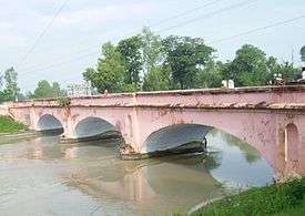 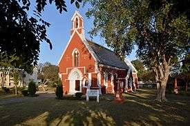 From top: Main Administrative Building of IIT Roorkee, The East India Company-era (1854) Ganeshpur Bridge over the Ganges Canal and St. John's Church. | |
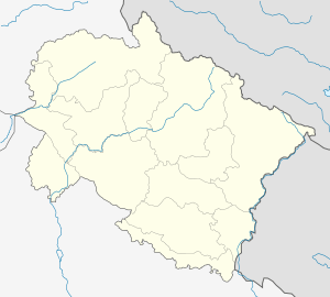 Roorkee Location in Uttarakhand, India | |
| Coordinates: 29°52′29.49″N 77°53′23.74″E | |
| Country | India |
| State | Uttarakhand |
| District | Haridwar |
| Founded | 1842 |
| Municipality | 1868 |
| Founded by | Proby Cautley |
| Government | |
| • Type | Mayor–council |
| • Body | Roorkee Municipal Corporation |
| • Mayor | Gaurav Goel, Independent |
| • Municipal Commissioner | Pravesh Chandra Dandiyal, IAS_(Indian Administrative Service) |
| Population (2011)[1] | |
| • Metro | 273,502 |
| Languages | |
| • Official | Hindi |
| Time zone | UTC+5:30 (IST) |
| PIN | 247667 |
| Telephone code | +91-1332 |
| Vehicle registration | UK-17 |
| Sex ratio | 1.12[2] ♂/♀ |
| Website | nagarnigamroorkee |
History
Before 1840, the city was a tiny hamlet consisting of mud huts on the banks of the Solani rivulet.[5] Digging work on the Upper Ganges Canal formally began in April 1842, under the aegis of Proby Cautley, a British officer. Local works were designed and overseen by the engineer Thomas Login.[6] Soon, Roorkee developed into a town. The canal, which was formally opened on 8 April 1854, provided irrigation waters for more than 767,000 acres (3,100 km²) in 5,000 villages.[7]
Col. P.T. Cautley, an officer in the British Army, was most instrumental in constructing the canal. According to Dept. of Hydrology the canal, which is still considered as a marvel of engineering, was built in 1853. However, water was released in the canal on 8 April 1854.
To look after the maintenance of canal, the Canal Workshop and Iron Foundry were established in 1843 on the civil lines on the canal bank which is known as Irrigation workshop nowadays. This was followed by the establishment of Civil Engineering School; classes started in 1845[5] to train local youth to assist in the civil-engineering work of the Upper Ganges Canal.[8] This was to become the first engineering college established in India.[9] On 25 November 1847, the college was formally constituted through a proposal by the Sir James Thomason, Lt. Governor of North Western Province (1843–53).[5] After his death in 1853, the college was rechristened as Thomason College of Civil Engineering. The college later upgraded to University of Roorkee in 1949; on 21 September 2001, through an Act of parliament, it was made one of the Indian Institutes of Technology, IIT Roorkee.[10] In 1853 Bengal Sappers and Miners were stationed here which provided a controlling influence during the 1857 uprising. Other important events in the history of Roorkee include that under the Post Office Act of 1866, it was among the first few towns to have a post office and first telegraph office in the district. Now Roorkee has a General Post Office (GPO) and a number of post offices located in Roorkee City and Cantt. In 1886, Roorkee was placed on the Railway map of India. In 1907, first provincial trunk road Meerut-Roorkee-Dehradun was constructed. In 1920, Roorkee became the first town in Uttar Pradesh to have Hydroelectricity.
India's first aqueduct was constructed over the Solani river, near Roorkee, part of the Ganges Canal project, which itself was India's first irrigation work in North India, started by the British.[11] The Ganges Canal led to another first for Roorkee — India's first steam engine Jenny Lind, (specially shipped from England moved on rails in India) ran in Roorkee on 22 December 1851, between Roorkee and Piran Kaliyar,[12] two years before the first passenger train ran from Bombay to Thane in 1853. Operated by the Bengal Sappers, the railway line was built to carry soil used for the construction of the Upper Ganges Canal aqueduct from Piran Kaliyar, 10 km (6.2 miles) from the city.[12][13] The locomotive rail paths are still intact. A replica of what the locomotive is thought to have looked like is exhibited at Roorkee Railway Station.
The municipality of Roorkee was created in 1868.[5] Now it is a Municipal Corporation. It had been home to the Bengal Sappers and Miners since 1853, and two artillery units were stationed there.[5] Today, the Roorkee Cantonment has a large army base. The Bengal Engineering Group and Centre (BEG&C), are still there today.
In 1901, when the city had a population of 17,197, it was made headquarters of the Roorkee Tehsil, in Saharanpur district of the United Province of the British Raj; the tehsil included in it 426 villages (of the parganas of Jwalapur, Manglaur and Bhagwanpur) and six towns, most important among them being Haridwar and Manglaur.[7] The Old Cemetery in the city is a protected monument, by the Archaeological Survey of India.[14]
Geography
Roorkee is located at 29.87°N 77.88°E.[15] It has an average elevation of 268 metres (879 feet).
Roorkee is 184.3 kilometres (114.5 mi) north of the Indian capital, New Delhi, between the rivers Ganges and Yamuna, close to the foothills of the Himalayas. It is 70.02 kilometres away from Dehradun, the capital of Uttarakhand. Before the creation of Uttarakhand on 9 November 2000,[16] Roorkee was a part of the state of Uttar Pradesh.
Climate
In Roorkee, the climate is warm and temperate. Roorkee is a city with significant rainfall. The climate here is classified as Cfa by the Köppen-Geiger system. The average annual temperature in Roorkee is 23.7 °C. In a year, the average rainfall is 1170 mm.
| Roorkee | ||||||||||||||||||||||||||||||||||||||||||||||||||||||||||||
|---|---|---|---|---|---|---|---|---|---|---|---|---|---|---|---|---|---|---|---|---|---|---|---|---|---|---|---|---|---|---|---|---|---|---|---|---|---|---|---|---|---|---|---|---|---|---|---|---|---|---|---|---|---|---|---|---|---|---|---|---|
| Climate chart (explanation) | ||||||||||||||||||||||||||||||||||||||||||||||||||||||||||||
| ||||||||||||||||||||||||||||||||||||||||||||||||||||||||||||
| ||||||||||||||||||||||||||||||||||||||||||||||||||||||||||||
| Climate data for Roorkee (1981–2010, extremes 1901–2012) | |||||||||||||
|---|---|---|---|---|---|---|---|---|---|---|---|---|---|
| Month | Jan | Feb | Mar | Apr | May | Jun | Jul | Aug | Sep | Oct | Nov | Dec | Year |
| Record high °C (°F) | 30.1 (86.2) |
31.9 (89.4) |
39.0 (102.2) |
43.8 (110.8) |
47.4 (117.3) |
46.7 (116.1) |
45.0 (113.0) |
39.8 (103.6) |
38.3 (100.9) |
38.3 (100.9) |
33.9 (93.0) |
30.5 (86.9) |
47.4 (117.3) |
| Average high °C (°F) | 20.1 (68.2) |
23.5 (74.3) |
28.8 (83.8) |
35.2 (95.4) |
37.7 (99.9) |
37.6 (99.7) |
33.8 (92.8) |
32.7 (90.9) |
32.7 (90.9) |
31.5 (88.7) |
27.4 (81.3) |
22.5 (72.5) |
30.3 (86.5) |
| Average low °C (°F) | 6.2 (43.2) |
8.4 (47.1) |
13.1 (55.6) |
18.3 (64.9) |
22.5 (72.5) |
24.4 (75.9) |
25.0 (77.0) |
24.6 (76.3) |
22.7 (72.9) |
17.0 (62.6) |
11.3 (52.3) |
7.3 (45.1) |
16.7 (62.1) |
| Record low °C (°F) | 4 (39) |
5 (41) |
5.3 (41.5) |
5.6 (42.1) |
11.1 (52.0) |
16.1 (61.0) |
18.8 (65.8) |
19.0 (66.2) |
15.2 (59.4) |
8.9 (48.0) |
2.2 (36.0) |
−0.7 (30.7) |
−2.2 (28.0) |
| Average rainfall mm (inches) | 31.0 (1.22) |
39.8 (1.57) |
34.7 (1.37) |
10.7 (0.42) |
31.8 (1.25) |
79.8 (3.14) |
255.8 (10.07) |
265.7 (10.46) |
183.3 (7.22) |
18.9 (0.74) |
3.9 (0.15) |
18.1 (0.71) |
973.5 (38.33) |
| Average rainy days | 2.2 | 2.5 | 2.4 | 1.4 | 2.8 | 4.3 | 9.5 | 11.2 | 5.7 | 1.0 | 0.5 | 1.1 | 44.6 |
| Average relative humidity (%) (at 17:30 IST) | 62 | 53 | 44 | 35 | 37 | 47 | 69 | 74 | 68 | 57 | 59 | 60 | 56 |
| Source: India Meteorological Department[17][18] | |||||||||||||
Demographics
According to the 2011 census Roorkee city has a population of 118,200.[1] The average literacy rate of Roorkee is 89.48%[19]
Languages
Major languages spoken in Roorkee are: Hindi 72% (including Garhwali Accent 0.35%), Urdu 23%, Punjabi 3%, English 2%[20]
References
- "City Census 2011". Census2011.co.in. 2011. Retrieved 30 September 2011.
- "Census of India, 2011". Office of the Registrar General, India. 2 March 2002. Archived from the original on 16 June 2004. Retrieved 28 May 2010.
- "Bengal Sappers’ saga of valour", The Tribune, 24 November 2008.
- "First train ran between Roorkee and Piran Kaliyar". The Hindu. 10 August 2002. Retrieved 15 February 2018.
- Roorkee Town2, The Imperial Gazetteer of India, v. 21, p. 325.
- "Obituary. Thomas Login, F.r.s.e., 1823-1874". Minutes of the Proceedings of the Institution of Civil Engineers. 39 (1875): 269–271. 1875. doi:10.1680/imotp.1875.22738.
- Upper Ganges Canal, The Imperial Gazetteer of India, v. 12, p. 138.
- Indian Engineering Colleges, The Imperial Gazetteer of India, 1909, v. 4, p. 321.
- Sandes, Lt Col E.W.C. (1935). The Military Engineer, Vol II. Chatham: Institution of Royal Engineers. p. 358.
- IIT Roorkee Official website.
- Irrigation and Navigation Imperial Gazetteer of India, 1909 v. 3, p. 341.
- Cautley, Proby Thomas (1 January 1860). Report on the Ganges canal works:from their commencement until the opening of the canal in 1854. London. p. 440. hdl:2027/uc1.$c19601.
- First train ran between Roorkee and Piran Kaliyar, The Hindu, 10 August 2002.
- Alphabetical List of Monuments – Uttarakhand Archaeological Survey of India website.
- "Falling Rain Genomics, Inc – Roorkee". Fallingrain.com. Retrieved 27 December 2011.
- Uttarakhand Govt. of India, Official website.
- "Station: Roorkee Climatological Table 1981–2010" (PDF). Climatological Normals 1981–2010. India Meteorological Department. January 2015. pp. 671–672. Archived from the original (PDF) on 5 February 2020. Retrieved 15 February 2020.
- "Extremes of Temperature & Rainfall for Indian Stations (Up to 2012)" (PDF). India Meteorological Department. December 2016. p. M228. Archived from the original (PDF) on 5 February 2020. Retrieved 15 February 2020.
- "Population in Roorkee City 2011". Office of the Registrar General and Census Commissioner, India. Retrieved 18 December 2017.
- "Census of India Website : Office of the Registrar General & Census Commissioner, India". www.censusindia.gov.in. Retrieved 28 August 2018.
External links
| Wikimedia Commons has media related to Roorkee. |

- Chisholm, Hugh, ed. (1911). . Encyclopædia Britannica. 23 (11th ed.). Cambridge University Press. p. 706.
- Roorkee biggest online directory is roorkeedigital
.com
| Authority control |
|---|
{{URL|