Jemez Mountains
The Jemez Mountains ([ˡhɛmɛz]) are a volcanic group of mountains in Rio Arriba, Sandoval, and Los Alamos counties, New Mexico, United States.
| Jemez Mountains | |
|---|---|
 Jemez Mountains | |
| Highest point | |
| Peak | Chicoma Mountain |
| Elevation | 3,524 m (11,562 ft) [1] NAVD 88 |
| Coordinates | 36°00′26″N 106°23′04″W |
| Geography | |
| State/Province | New Mexico |
| Topo map | USGS Polvadera Peak (1977) |
Numerous Puebloan Indian tribes have lived in the Jemez Mountains region since before the Spanish arrived in New Mexico. The Pueblo Indians of this region are the Towa-speaking Jemez people for which this mountain range is named, the Keres-speaking Keresan Indians, and the Tewa-speaking Tewa Indians. Tsąmpiye'ip'įn is the Tewa language name for the Jemez Mountains.
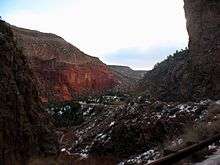
The highest point in the range is Chicoma Mountain (also spelled as Tschicoma or Tchicoma) at an elevation of 11,561 feet (3524 meters). The town of Los Alamos and Los Alamos National Laboratory adjoin the eastern side of the range while the town of Jemez Springs is to the west. Pajarito Mountain Ski Area is the only ski area in the Jemez. New Mexico State Highway 4 is the primary road that provides vehicular access to locations in the Jemez Mountains.
Geology
The Jemez Mountains lie to the north of the Albuquerque Basin in the Rio Grande rift.[2] They are a classic example of intracontinental volcanism and consist of a broadly circular ridge surrounding the famous Valles Caldera. The latter is the type location for resurgent caldera eruptions.[3]
The mountains lie on the intersection of the western margin of the Rio Grande Rift and the Jemez Lineament.[4][5] Here magma produced from the fertile rock of an ancient subduction zone has repeatedly found its way to the surface along faults produced by rifting. This has produced a long-lived volcanic field, with the earliest eruptions beginning at least 13 million years ago[6] and continuing almost to the present day, the most recent known eruption being the obsidian of the Banco Bonito flow, dated to 68.3 ± 1.5 thousand years before the present.[7]
Most of the volume of the range is composed of pre-caldera basalts, andesites, and dacites of the Keres Group and Polvadera Group, but there are extensive outflow sheets of the Bandelier Tuff[8] and young rhyolites associated with caldera resurgence, all assigned to the Tewa Group.[9][10][11][6]
The two most recent caldera-forming eruptions, dated to about 1.62 million and 1.256 million years ago,[12] produced massive ignimbrite deposits known as the Otowi and Tshirege members, respectively, of the Bandelier Tuff.[13] Much of the material in these deposits now forms the Pajarito Plateau, a scenic region of canyons and mesas on which Los Alamos is situated. Redondo Peak, the second-highest summit in the range at 11,254 ft (3431 m), is a resurgent dome in the middle of the Valles Caldera, which also contains several smaller volcanos. The caldera is segregated by these structures and its rim into multiple lush grass valleys (valles in Spanish, hence the name).
Public use
Much of the range is federal land, including Santa Fe National Forest, Bandelier National Monument, and the Valles Caldera National Preserve. State lands include Fenton Lake State Park [14] at 35°52′58″N 106°43′46″W in Sandoval County. Hiking trails crisscross the range and lead to many of the summits, although some regions are closed to hikers either because of environmental restrictions or because they are on the territory of Santa Clara Pueblo or private landholders. (Access to pueblo lands is available by permit.) The summits are generally easy to climb (in good weather) and require no technical climbing skills, but rock climbing is popular on some of the basalt cliffs near Los Alamos, Caja del Rio and elsewhere in the range. The mountains also are home to Pajarito Mountain, a small downhill ski area and offer some opportunities for cross country skiing, although not every winter produces enough snow to support this recreational activity. The region is prone to forest fires because of the tendency for spring weather to be dry and windy, creating conditions under which fires caused by human activities or lightning can spread rapidly. The Las Conchas Fire in 2011 was the most recent large wildfire. Parts of Los Alamos National Laboratory were also damaged, although none of the laboratory's special nuclear materials were threatened or released.
Communities
Census-designated places within the Jemez Mountains include Jemez Springs and Jemez Pueblo.
Wildlife
The Jemez Mountains house the American elk (wapiti), the golden-mantled ground squirrel, the Gunnison's prairie dog, American beavers, black bears, and mountain lions. The Jemez Mountains are also home to a federally endangered species, the Jemez Mountains salamander.
References
- "Langley". NGS data sheet. U.S. National Geodetic Survey. Retrieved 2008-12-22.
- Pinet, Bertrand; Bois, Christian; Bois, C. (1990). The Potential of Deep Seismic Profiling for Hydrocarbon Exploration: Proceedings of the 5th IFP Exploration and Production Research Conference, Held in Arles, June 19-23, 1989. Editions TECHNIP. p. 178. ISBN 978-2-7108-0590-8. Retrieved 2012-09-30.
- Smith, R.L.; Bailey, R.A. (1968). "Resurgent cauldrons". Memoir of the Geological Society of America. 116. doi:10.1130/MEM116-p613.
- Aldrich Jr., M. J. (1986). "Tectonics of the Jemez Lineament in the Jemez Mountains and Rio Grande Rift". Journal of Geophysical Research. 91 (B2): 1753–1762. Bibcode:1986JGR....91.1753A. doi:10.1029/JB091iB02p01753.
- Whitmeyer, Steven; Karlstrom, Karl E. (2007). "Tectonic model for the Proterozoic growth of North America". Geosphere. 3 (4): 220. doi:10.1130/GES00055.1. Retrieved 18 April 2020.
- Heiken, G; Goff, F; Gardner, J N; Baldridge, W S; Hulen, J B; Nielson, D L; Vaniman, D (May 1990). "The Valles/Toledo Caldera Complex, Jemez Volcanic Field, New Mexico". Annual Review of Earth and Planetary Sciences. 18 (1): 27–53. doi:10.1146/annurev.ea.18.050190.000331.
- Zimmerer, Matthew J.; Lafferty, John; Coble, Matthew A. (January 2016). "The eruptive and magmatic history of the youngest pulse of volcanism at the Valles caldera: Implications for successfully dating late Quaternary eruptions". Journal of Volcanology and Geothermal Research. 310: 50–57. doi:10.1016/j.jvolgeores.2015.11.021.
- Ross, Clarence S.; Smith, Robert L. (1961). "Ash-flow tuffs: Their origin, geologic relations, and identification". USGS Profession Paper Series (366). doi:10.3133/pp366.
- Smith, R.L.; Bailey, R.A.; Ross, C.S. (1969). "Stratigraphic Nomenclature of ' Volcanic Rocks in the Jemez Mountains, New Mexico" (PDF). GEOLOGICAL SURVEY BULLETIN (1274-P). Retrieved 4 May 2020.
- Kudo, A.M. (1974). "OUTLINE OF THE IGNEOUS GEOLOGY OF THE JEMEZ MOUNTAINS VOLCANIC FIELD". New Mexico Geological Society Field Conference Series (25): 287–289. Retrieved 4 May 2020.
- GUILBEAU, KEVIN P.; KUDO, A. M. (1985). "Petrology and geochemistry of the Paliza Canyon Formation and the Bearhead Rhyolite, Keres Group, Jemez Mountains, New Mexico". Geological Society of America Bulletin. 96 (1): 108. doi:10.1130/0016-7606(1985)96<108:PAGOTP>2.0.CO;2.
- Phillips, Erin H. (May 2004). COLLAPSE AND RESURGENCE OF THE VALLES CALDERA, JEMEZ MOUNTAINS, NEW MEXICO: 40 AR / 39 AR AGE CONSTRAINTS ON THE TIMING AND DURATION OF RESURGENCE AND AGES OF MEGABRECCIA BLOCKS (master's thesis). Socorro, New Mexico: New Mexico Institute of Mining and Technology. Retrieved 4 May 2020.
- Dethier, David P.; Kampf, Stephanie K. (2007). Geology of the Jemez Region II. Ne Mexico Geological Society. p. 499 p. Retrieved 6 November 2015.
- Official website: Fenton Lake State Park
External links
| Wikimedia Commons has media related to Jemez Mountains. |
| Wikivoyage has a travel guide for Jemez Mountains. |