Sierra Grande
Sierra Grande is an extinct shield volcano in northeastern New Mexico that rises 2,200 feet above the surrounding plain. It is part of the inactive Raton-Clayton volcanic field.
| Sierra Grande | |
|---|---|
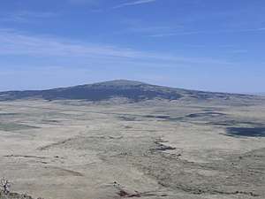 Sierra Grande seen from the top of Capulin Volcano. | |
| Highest point | |
| Elevation | 8,723 ft (2,659 m) NAVD 88[1] |
| Prominence | 1,880 ft (570 m) [1] |
| Coordinates | 36°42′20″N 103°52′36″W [2] |
| Geography | |
| Location | Union County, New Mexico, U.S. |
| Topo map | USGS Capulin |
| Geology | |
| Mountain type | Shield volcano |
| Volcanic field | Raton-Clayton volcanic field |
| Climbing | |
| Easiest route | Hike |
Geography
The eastern slopes of Sierra Grande contain the easternmost point in the United States over 8,000 feet (2,400 m) above sea level.[3]
U.S. Highway 64, U.S. Highway 87 and the Colorado and Southern Railway run along the north and east of the volcano. The town of Des Moines is just to the northeast. To the northwest is Capulin Volcano National Monument featuring Capulin Volcano, an extinct cinder cone also in the Raton-Clayton volcanic field.
 Sierra Grande as seen from the north along US Highways 64 and 87 |
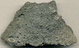 Andesite from a 1.9 million year old lava flow, on the eastern side of Sierra Grande. |
References
| Wikimedia Commons has media related to Sierra Grande. |
| Wikimedia Commons has media related to Raton-Clayton volcanic field. |
- "Sierra Grande, New Mexico". Peakbagger.com. Retrieved 2013-01-26.
- "Sierra Grande". Geographic Names Information System. United States Geological Survey. Retrieved 2013-01-26.
- DeLorme Topo 6.0
- Wood, Charles A.; Jürgen Kienle, eds. (1990). Volcanoes of North America. Cambridge University Press. ISBN 0-521-43811-X.
- "Volcano World: Capulin Mountain and Sierra Grande". Retrieved 2007-03-26.
External links
This article is issued from Wikipedia. The text is licensed under Creative Commons - Attribution - Sharealike. Additional terms may apply for the media files.