Capitan Mountains
The Capitan Mountains are a mountain range in Lincoln County, in south-central New Mexico in the southwestern United States. The range is about 20 miles (32 km) long from east to west being about 6 miles (10 km) wide and were formed from a large elongated granite intrusion similar to the round one that produced Carrizo Mountain to the west.
| Capitan Mountains | |
|---|---|
 | |
| Highest point | |
| Elevation | 10,170 ft (3,100 m) |
| Coordinates | 33.61056°N 105.41333°W |
| Geography | |
 Capitan Mountains Location of the mountain | |
| Location | Lincoln County, New Mexico |
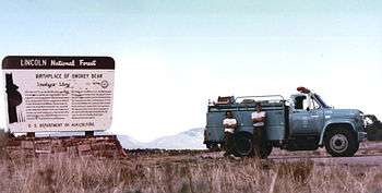
The small town of Capitan is on the southwestern side of the mountain and is the location of Smokey Bear Historical Park. This is the park that memorializes the famous bear that was rescued from the Capitan Gap Fire in the Capitan Mountains. The highest point in the range is an unnamed peak reaching 10,201 feet (3139 m) which is118 feet (36 m) higher than Capitan Peak. The entirety of the range lies within Lincoln National Forest and is separated from the Sacramento Mountains to the south and Sierra Blanca to the southwest by the valley of Rio Bonito.
The Spanish used this mountain range as a landmark (due to it being the only East to West mountain range in New Mexico) on their way between Mexico and Santa Fe.