Keres Group
The Keres Group is a group of geologic formation exposed in and around the Jemez Mountains of northern New Mexico. Radiometric dating gives it an age of 13 to 6 million years, corresponding to the Miocene epoch.
| Keres Group Stratigraphic range: Mid-Late Miocene ~13–6 Ma | |
|---|---|
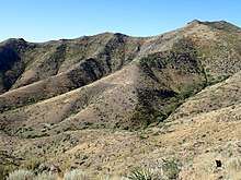 St Peters Dome, a mountain underlain by Keres Group beds | |
| Type | Group |
| Sub-units | See text |
| Underlies | Polvadera & Tewa Groups |
| Overlies | Santa Fe Group |
| Thickness | 900 m (3,000 ft) |
| Lithology | |
| Primary | Andesite |
| Other | Basalt, dacite, rhyolite |
| Location | |
| Coordinates | 35.796°N 106.547°W |
| Region | |
| Country | |
| Extent | Jemez Mountains |
| Type section | |
| Named for | Keresean Range (see text) |
| Named by | Bailey, Smith & Ross |
| Year defined | 1969 |
Geology
The Jemez Mountains lie on the intersection of the western margin of the Rio Grande Rift and the Jemez Lineament.[1][2] Here magma produced from the fertile rock of an ancient subduction zone[3] has repeatedly found its way to the surface along faults produced by rifting. This has produced a long-lived volcanic field, with the earliest eruptions beginning at least 13 million years ago in both the northern (Polvadera Group) and southern (Keres Group) portions of the volcanic field.[4] High-silica eruptions of the Tewa Group began about 1.85 million years ago and continued almost to the present day.[5]
The Keres Group is a sequence of basalt, andesite, dacite, and rhyolite flows that underlie the southern Jemez Mountains. It overlaps the Polvadera Group to the north and has a maximum thickness of about 900 meters (3,000 feet). It overlies the Santa Fe Group and is overlain by the Tewa Group.[6] Keres volcanism began about 12 million years ago and continued to 6 million years ago. Volcanic activity generally shifted eastward over time during this interval.[7]
Formations
From oldest to youngest, the formations recognized within the Keres Group are the Paliza Canyon Formation, the Canovas Canyon Rhyolite, and the Bearhead Rhyolite.
The Paliza Canyon Formation is a sequence of mostly andesite flows that is widely exposed in the southern Jemez Mountains. The formation was erupted by numerous coalesced composite volcanoes centered on a axis from the northern Valles Caldera wall south through Paliza and Peralta Canyons to Ruiz Peak (35.717°N 106.544°W). Exposures along this axis generally exceed 500 meters (1,600 feet). The base of the formation is not exposed along this axis, but is estimated from exposures to the west to be about 900 meters (3,000 feet).
The formation rests on rocks dating from the Permian to the Miocene. These include red beds of the Abo Formation in the valley of the Rio Guadalupe in the western Jemez and in upper Canon de San Diego; Chinle Formation beds in lower Paliza Canyon; Abiquiu Formation on the west wall of the Valles caldera and in upper San Juan Canyon; and Santa Fe Group at the east foot of St. Peter's Dome to the east. The Paliza Canyon Formation is intruded and locally overlain by Bearhead Rhyolite. In the north and northwest wall of the Valles caldera, the Paliza Canyon Formation appears to be conformably overlain with dacite and quartz latite flows of the Tschicoma Formation (Polvadera Group). However, the alteration of the Paliza Canyon beds in contrast with the fresh appearance of the Tschicoma beds suggests a disconformity between the formations. The Paliza Canyon Formation is also locally overlain unconformably by the Bandelier Tuff.[6]
Beds assigned to the Basalt of Chamisa Mesa have since been found to be unremarkable in age and composition and are now assigned to the Paliza Canyon Formation.[8]
The Canovas Canyon Formation is a sequence of rhyolite flows, tuffs, domes, and associated shallow intrusions exposed primarily around Bear Springs Peak (35.669°N 106.559°W). The formation is named for exposures in Canovas Canyon (35.607°N 106.573°W). It has a maximum exposed thickness of 300 meters (980 feet) and extends to Borrego Mesa to the southwest.[9] Isolated exposures are found further to the east as far as the San Miguel Mountains.[10] The formation is generally overlain and interbedded with flows of the Paliza Canyon Formation. It overlies beds of the Santa Fe Group.[9] Radimetric ages for this formation range from 12 to 8 million years.[7]
The Bearhead Rhyolite is a thick stack of rhyolite tuffs, flows, domes, and associated shallow intrusions exposed from the northeastern Valles caldera rim to north of Cochiti Pueblo. It is named for exposures on Bearhead Peak (35.725°N 106.483°W), one of the major source vents of the formation. The formation ranges in age from 7.1 to 6.5 million years. High-silica volcanism shifted to the north around 7.5 million years ago, producing the separation between the Canovas Canyon Rhyolite and the Bearhead Rhyolite.[7]
The Bearhead Rhyolite rests on an erosional surface cut mostly on flows of the Paliza Canyon Formation. Its uppermost beds interfinger with the Cochiti Formation.[11]
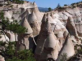
The tuffaceous facies of the Bearhead Rhyolite, extensively exposed at Kasha-Katuwe Tent Rocks National Monument, are assigned to the Peralta Tuff Member, a name first used by Kirk Bryan and J. E. Upson. The member is named for its exposures in Peralta Canyon. It consists mainly of bedded air-fall tuffs but includes pyroclastic flows and reworked tuffs.
Economic geology
Gold has been mined from the Bland district,[12] from beds identified as the exhumed interior of a Keres Group volcano.[8]
History
The group was first defined by Bailey, Smith, and Ross in 1969 as part of their work establishing the stratigraphy of the Jemez Mountains. The group was named for the Keresean Range, an older name for the southern Jemez Mountains. They included in the group the Basalt of Chamisa Mesa, the Canovas Canyon Rhyolite, the Paliza Canyon Formation, and the Bearhead Rhyolite.[13] The Basalt of Chamisa Mesa has since been abandoned as a formation name, since it is similar in age and composition to the Paliza Canyon Formation.[8]
The division of the precaldera formations of the Jemez Mountains into the Keres and Polvadera Groups, based largely on geography, has been criticized as artificial.[8][14] Goff et al. abandoned the Polvadera Group in their 2011 mapping of the Valles Caldera and included its formations in the Keres Group.[15]
References
- Aldrich 1986
- Whitmeyer and Karlstrom 2007
- Wolff et al. 2004
- Heiken et al. 1990
- Zimmerer et al. 2016
- Smith et al. 1969, pp.2-8
- Kelley et al. 2013
- Gardner et al. 1986
- Smith et al. 1969, pp.5-6
- Goff et al. 2002
- Smith et al. 1969, p.8
- Vieth 1950
- Smith et al. 1969, p.5
- Rowe et al. 2007
- Goff et al. 2011
Bibliography
- Aldrich Jr., M. J. (1986). "Tectonics of the Jemez Lineament in the Jemez Mountains and Rio Grande Rift". Journal of Geophysical Research. 91 (B2): 1753–1762. Bibcode:1986JGR....91.1753A. doi:10.1029/JB091iB02p01753.
- Gardner, Jamie N.; Goff, Fraser; Garcia, Sammy; Hagan, Roland C. (1986). "Stratigraphic relations and lithologic variations in the Jemez Volcanic Field, New Mexico". Journal of Geophysical Research. 91 (B2): 1763. doi:10.1029/JB091iB02p01763.
- Goff, Fraser; Gardner, Jamie N.; Reneau, Steven L. (2002). "Geology of the Frijoles quadrangle, Los Alamos, Sandoval, and Santa Fe Counties, New Mexico". New Mexico Burea of Geology and Mineral Resources Open File Geologic Map Series. 42. Retrieved 16 May 2020.
- Goff, Fraser; Gardner, Jamie N.; Reneau, Steven L.; Kelley, Shari A.; Kempter, Kirt A.; Lawrence, John R. (2011). "Geologic map of the Valles caldera, Jemez Mountains, New Mexico". New Mexico Bureau of Geology and Mineral Resources Map Series. 79. Retrieved 18 May 2020.
- Heiken, G; Goff, F; Gardner, J N; Baldridge, W S; Hulen, J B; Nielson, D L; Vaniman, D (May 1990). "The Valles/Toledo Caldera Complex, Jemez Volcanic Field, New Mexico". Annual Review of Earth and Planetary Sciences. 18 (1): 27–53. doi:10.1146/annurev.ea.18.050190.000331.
- Kelley, Shari A.; McIntosh, William C.; Goff, Fraser; Kempter, Kirt A.; Wolff, John A.; Esser, Richard; Braschayko, Suzanne; Love, David; Gardner, Jamie N. (June 2013). "Spatial and temporal trends in pre-caldera Jemez Mountains volcanic and fault activity". Geosphere. 9 (3): 614–646. doi:10.1130/GES00897.1.
- Rowe, M. C.; Wolff, J. A.; Gardner, J. N.; Ramos, F. C.; Teasdale, R.; Heikoop, C. E. (November 2007). "Development of a Continental Volcanic Field: Petrogenesis of Pre-caldera Intermediate and Silicic Rocks and Origin of the Bandelier Magmas, Jemez Mountains (New Mexico, USA)". Journal of Petrology. 48 (11): 2063–2091. doi:10.1093/petrology/egm050.
- Smith, R.L.; Bailey, R.A.; Ross, C.S. (1969). "Stratigraphic Nomenclature of ' Volcanic Rocks in the Jemez Mountains, New Mexico" (PDF). GEOLOGICAL SURVEY BULLETIN (1274-P). Retrieved 4 May 2020.
- Vieth, Francis E. (May 14, 1950). The Rise and Decline of the Cochiti (Bland) Gold Mining District (master's thesis). Albuquerque, New Mexico: University of New Mexico. Retrieved 16 May 2020.
- Whitmeyer, Steven; Karlstrom, Karl E. (2007). "Tectonic model for the Proterozoic growth of North America". Geosphere. 3 (4): 220. doi:10.1130/GES00055.1. Retrieved 18 April 2020.
- WOLFF, J. A. (14 October 2004). "Petrogenesis of Pre-caldera Mafic Lavas, Jemez Mountains Volcanic Field (New Mexico, USA)". Journal of Petrology. 46 (2): 407–439. doi:10.1093/petrology/egh082.
- Zimmerer, Matthew J.; Lafferty, John; Coble, Matthew A. (January 2016). "The eruptive and magmatic history of the youngest pulse of volcanism at the Valles caldera: Implications for successfully dating late Quaternary eruptions". Journal of Volcanology and Geothermal Research. 310: 50–57. doi:10.1016/j.jvolgeores.2015.11.021.