Granger, Indiana
Granger is a census-designated place (CDP) in Clay and Harris townships, St. Joseph County, in the U.S. state of Indiana.[3] The population was 30,465 at the 2010 census. Penn-Harris-Madison School Corporation and the South Bend Community School Corporation maintain the public schools in the area. Granger is part of the South Bend–Mishawaka, IN-MI, South Bend – Mishawaka metropolitan area as well as the larger Michiana region.
Granger, Indiana | |
|---|---|
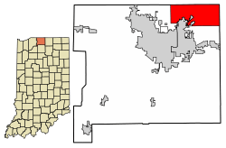 Location of Granger in St. Joseph County, Indiana. | |
| Coordinates: 41°44′18″N 86°8′56″W | |
| Country | United States |
| State | Indiana |
| County | St. Joseph |
| Township | Clay, Harris |
| Area | |
| • Total | 26.2 sq mi (67.9 km2) |
| • Land | 26.2 sq mi (67.9 km2) |
| • Water | 0.0 sq mi (0.0 km2) |
| Elevation | 797 ft (243 m) |
| Population (2010) | |
| • Total | 30,465 |
| • Density | 1,079/sq mi (416.5/km2) |
| Time zone | UTC-5 (Eastern (EST)) |
| • Summer (DST) | UTC-4 (EDT) |
| ZIP code | 46530 |
| Area code(s) | 574 |
| FIPS code | 18-28800[2] |
| GNIS feature ID | 452610 |
History
Granger was founded in 1883, and named after the Grangers fraternal organization.[4] The Granger post office has been in operation since 1875.[5]
Geography
Granger is located at 41°44′18″N 86°8′56″W (41.738320, −86.148777).[6] According to the United States Census Bureau, the CDP has a total area of 26.2 square miles (68 km2), all land.
Demographics
| Historical population | |||
|---|---|---|---|
| Census | Pop. | %± | |
| 1990 | 20,241 | — | |
| 2000 | 28,284 | 39.7% | |
| 2010 | 30,465 | 7.7% | |
| U.S. Decennial Census | |||
As of the census[2] of 2000, there were 28,284 people, 9,184 households, and 8,173 families residing in the CDP. The population density was 1,078.8 people per square mile (416.5/km²). There were 9,401 housing units at an average density of 358.6/sq mi (138.4/km²). The racial makeup of the CDP was 94.15% White, 1.74% African American, 0.12% Native American, 2.63% Asian, 0.02% Pacific Islander, 0.26% from other races, and 1.07% from two or more races. Hispanic or Latino of any race were 1.21% of the population.
There were 9,184 households, out of which 48.1% had children under the age of 18 living with them, 82.7% were married couples living together, 4.7% had a female householder with no husband present, and 11.0% were non-families. 9.1% of all households were made up of individuals and 3.4% had someone living alone who was 65 years of age or older. The average household size was 3.06 and the average family size was 3.26.
In the CDP, the population was spread out with 31.7% under the age of 18, 5.2% from 18 to 24, 27.2% from 25 to 44, 27.9% from 45 to 64, and 8.1% who were 65 years of age or older. The median age was 38 years. For every 100 females, there were 97.6 males. For every 100 females age 18 and over, there were 95.9 males.
The median income for a household in the CDP was $80,744, and the median income for a family was $83,171. Males had a median income of $61,255 versus $33,620 for females. The per capita income for the CDP was $31,367. About 1.0% of families and 1.4% of the population were below the poverty line, including 1.4% of those under age 18 and 1.2% of those age 65 or over.
Education
Penn-Harris-Madison School Corporation serves most of Granger. South Bend Community School Corporation serves students in Clay Township in the western part of Granger while the far eastern tip of Granger located within Elkhart County is served by Elkhart Community Schools. The following schools lie within the boundaries of Granger:
Middle schools
- Discovery Middle School
- Schmucker Middle School
- Grissom Middle School
Elementary schools
- Horizon Elementary School
- Mary Frank Elementary School
- Northpoint Elementary School
- Prairie Vista Elementary School
Granger also has some private elementary schools, including:
- Calvary Christian School
- Granger Christian School
- Peace Lutheran School[7]
- New Creation Academy
- St. Pius X Catholic School
Public library
Granger has a public library, a branch of the Mishawaka-Penn-Harris Public Library system.[8]
Notable people
- Braxston Cave – football player for the Detroit Lions
- Joe Donnelly – former U.S. Senator
- Ken Harrelson – former Major League Baseball player and retired announcer for the Chicago White Sox Major League Baseball Team.[9]
- Ara Parseghian – former head coach at Notre Dame[10]
References
- "US Board on Geographic Names". United States Geological Survey. 2007-10-25. Retrieved 2008-01-31.
- "U.S. Census website". United States Census Bureau. Retrieved 2008-01-31.
- American Indian Areas, Counties, County Subdivisions, and Places – Section 2, Indiana [map]. United States Census Bureau.
- Howard, Timothy Edward (1907). A History of St. Joseph County, Indiana. Lewis publishing Company. p. 311.
- "Saint Joseph County". Jim Forte Postal History. Retrieved November 6, 2016.
- "US Gazetteer files: 2010, 2000, and 1990". United States Census Bureau. 2011-02-12. Retrieved 2011-04-23.
- "Peace Lutheran Church in Granger, Indiana – Peace Lutheran School (Preschool – 8)".
- "Homepage". Mishawaka-Penn-Harris Public Library. Retrieved 15 March 2018.
- Keagle, Lauri Harvey. "At Home with the Hawk". nwitimes.com. Retrieved 4 August 2017.
- "Ailing coach Ara Parseghian being treated at home – Notre Dame – Journal Gazette". www.journalgazette.net. Retrieved 4 August 2017.
Municipalities and communities of St. Joseph County, Indiana, United States | ||
|---|---|---|
| Cities | Map of Indiana highlighting St. Joseph County | |
| Towns | ||
| Townships | ||
| CDPs | ||
| Unincorporated communities | ||
| Footnotes | ‡This populated place also has portions in an adjacent county or counties | |
| Authority control |
|
|---|