Orange County, Indiana
Orange County is located in southern Indiana in the United States. As of 2010, its population was 19,840, an increase of 2.8% from 19,306 in 2000.[1] The county seat is Paoli.[2] The county has four incorporated settlements with a total population of about 8,600,[3] as well as several small unincorporated communities. It is divided into 10 townships which provide local services.[4][5] One U.S. route and five Indiana state roads pass through or into the county.[6]
Orange County | |
|---|---|
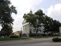
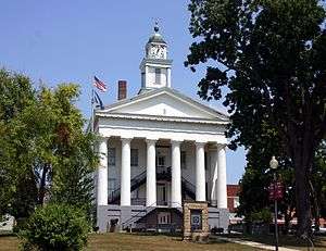 The Orange County courthouse in Paoli | |
 Location within the U.S. state of Indiana | |
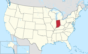 Indiana's location within the U.S. | |
| Coordinates: 38°32′N 86°30′W | |
| Country | |
| State | |
| Founded | February 1, 1816 |
| Named for | House of Orange-Nassau |
| Seat | Paoli |
| Largest town | Paoli |
| Area | |
| • Total | 408.19 sq mi (1,057.2 km2) |
| • Land | 398.39 sq mi (1,031.8 km2) |
| • Water | 9.80 sq mi (25.4 km2) 2.40%% |
| Population | |
| • Estimate (2018) | 19,489 |
| • Density | 49.7/sq mi (19.17/km2) |
| Time zone | UTC−5 (Eastern) |
| • Summer (DST) | UTC−4 (EDT) |
| Congressional district | 9th |
| Indiana county number 59 | |
History
Orange County was formed from parts of Knox County, Gibson County and Washington County by the Indiana Territorial Legislature, on December 26, 1815 (effective February 1, 1816). In 1816 the Orange County seat was designated at Paoli, which was named after Pasquale Paoli Ash, the 12-year-old son of the sitting North Carolina Governor.[7]
The first courthouse was a temporary log structure that was built for $25; a more permanent stone structure was completed in 1819 at a cost of $3,950.[n 1] [9] In 1847, plans were made for a larger courthouse, which was completed in 1850 at a cost of $14,000.[n 2] This building is the second oldest courthouse in the state that has been continuously used since its construction. Like the oldest in Ohio County, it is a Greek Revival building with two stories and a Doric portico supported by fluted columns; it has ornamental iron stairs and a clock tower. In 1970, the clock tower was damaged by fire.[10]
The early settlers were mostly Quakers fleeing the institution of slavery in Orange County, North Carolina. Jonathan Lindley brought his group of Quakers from North Carolina to the area in 1811. They were the first to build a religious structure, the Lick Creek Meeting House in 1813. It was from this group that Orange County got its name.[11][12] (See List of Indiana county name etymologies). The name Orange derives from the Dutch Protestant House of Orange, which accessed the English throne with the accession of King William III in 1689, following the Glorious Revolution.
When the North Carolina Quakers came to Indiana, they brought with several freed slaves. These free men were deeded 200 acres (0.81 km2) of land in the heart of a dense forest. Word of mouth soon spread the news, and this land became part of the "underground railroad" for runaway slaves. For many years, the freed slaves in this area farmed, traded, and sold their labor to others while living in this settlement. A church and cemetery were constructed.
All that remains today is the cemetery, with many lost or vandalized headstones. Several years ago, Boy Scouts restored the cemetery, replacing the stones with wooden crosses designating a grave. The name of "Little Africa" came about because of the black settlement, but it was called "Paddy's Garden" by its early users.
Geography
Much of the south part of the county, south of Paoli and French Lick, is part of the Hoosier National Forest. Patoka Lake is within the national forest; the majority of the lake lies in Orange County, with parts extending into neighboring Dubois and Crawford counties.
According to the 2010 United States Census, Orange County has a total area of 408.19 square miles (1,057.2 km2), of which 398.39 square miles (1,031.8 km2) (or 97.60%) is land and 9.80 square miles (25.4 km2) (or 2.40%) is water.[13]
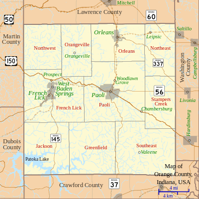
Adjacent counties
- Lawrence County – north
- Washington County – east
- Crawford County – south
- Dubois County – southwest
- Martin County – northwest
Towns and villages
- French Lick
- Orleans
- Paoli (county seat)
- West Baden Springs.
Unincorporated communities
- Abydel
- Bacon
- Bonds
- Bromer
- Chambersburg
- Ethel
- Fargo – called Pittsburgh before 1888
- Greenbrier - also Green Brier
- Hindostan
- Leipsic – called Lancaster before 1852
- Lost River
- Mahan Crossing
- Millersburg
- Newton Stewart
- Norton − called Dillon before 1908
- Orangeville
- Pearsontown
- Pine Valley
- Prospect – called New Prospect before 1853
- Pumpkin Center
- Rego
- Roland
- Scarlet
- Stampers Creek
- Syria
- Trotter Crossing
- Turleys
- Valeene
- Woodlawn Grove
- Youngs Creek – called Unionville before 1867
Transportation
Highways
- U.S. Route 150 – runs east-west through central part of county. Passes French Lick, Turleys, and Paoli.


Airports
- Paoli Municipal Airport - public-owned public-use general-aviation airport with one paved runway.
Railways
There are no railroad lines in Orange County.
Climate and weather
| Paoli, Indiana | ||||||||||||||||||||||||||||||||||||||||||||||||||||||||||||
|---|---|---|---|---|---|---|---|---|---|---|---|---|---|---|---|---|---|---|---|---|---|---|---|---|---|---|---|---|---|---|---|---|---|---|---|---|---|---|---|---|---|---|---|---|---|---|---|---|---|---|---|---|---|---|---|---|---|---|---|---|
| Climate chart (explanation) | ||||||||||||||||||||||||||||||||||||||||||||||||||||||||||||
| ||||||||||||||||||||||||||||||||||||||||||||||||||||||||||||
| ||||||||||||||||||||||||||||||||||||||||||||||||||||||||||||
In recent years, average temperatures in Paoli have ranged from a low of 18 °F (−8 °C) in January to a high of 87 °F (31 °C) in July, although a record low of −29 °F (−34 °C) was recorded in January 1994 and a record high of 111 °F (44 °C) was recorded in July 1901. Average monthly precipitation ranged from 2.90 inches (74 mm) in October to 5.14 inches (131 mm) in May.[15]
Government
The county government is a constitutional body granted specific powers by the Constitution of Indiana and the Indiana Code. The county council is the legislative branch of the county government and controls all spending and revenue collection. Representatives are elected from county districts. The council members serve four-year terms and are responsible for setting salaries, the annual budget and special spending. The council also has limited authority to impose local taxes, in the form of an income and property tax that is subject to state level approval, excise taxes and service taxes.[16][17]
A board of commissioners is the county's executive body. Commissioners are elected in staggered four-year terms. The board is charged with executing the council's decisions, with collecting revenue, and with managing the county government.[16][17]
The county maintains a small claims court that can handle some civil cases. The judge on the court is elected to a term of four years and must be a member of the Indiana Bar Association. The judge is assisted by a constable who is elected to a four-year term. In some cases, court decisions can be appealed to the state level circuit court.[17]
The county has several other elected offices, including sheriff, coroner, auditor, treasurer, recorder, surveyor and circuit court clerk. Each serves a four-year term, and oversees a different part of county government. Members elected to county government positions are required to declare party affiliations and be residents of the county.[17]
Each township has a trustee and a three-member board, which administers rural fire protection and ambulance service, provides poor relief and manages cemetery care, among other duties.[5] The trustee and board members are elected to four-year terms.[18]
Orange County is part of Indiana's 9th congressional district. It is part of Indiana Senate districts 44 and 48,[19] and Indiana House of Representatives district 62.[20]
| Year | Republican | Democratic | Third parties |
|---|---|---|---|
| 2016 | 70.8% 5,803 | 25.0% 2,048 | 4.2% 341 |
| 2012 | 59.4% 4,617 | 37.8% 2,939 | 2.8% 220 |
| 2008 | 55.9% 4,536 | 41.8% 3,390 | 2.2% 182 |
| 2004 | 65.7% 5,683 | 33.3% 2,885 | 1.0% 84 |
| 2000 | 62.9% 4,687 | 34.9% 2,601 | 2.3% 170 |
| 1996 | 45.7% 3,355 | 41.1% 3,016 | 13.2% 972 |
| 1992 | 46.6% 3,738 | 36.8% 2,948 | 16.6% 1,329 |
| 1988 | 65.4% 5,245 | 34.2% 2,739 | 0.4% 31 |
| 1984 | 69.4% 5,909 | 30.2% 2,571 | 0.4% 35 |
| 1980 | 59.3% 5,073 | 37.7% 3,228 | 3.0% 257 |
| 1976 | 51.9% 4,399 | 47.6% 4,031 | 0.5% 46 |
| 1972 | 65.9% 5,715 | 33.8% 2,932 | 0.3% 27 |
| 1968 | 54.8% 4,666 | 34.3% 2,918 | 10.9% 928 |
| 1964 | 48.1% 4,187 | 51.6% 4,490 | 0.4% 33 |
| 1960 | 59.2% 5,589 | 40.4% 3,818 | 0.4% 35 |
| 1956 | 62.4% 5,751 | 37.3% 3,438 | 0.4% 32 |
| 1952 | 62.4% 5,551 | 36.8% 3,272 | 0.8% 75 |
| 1948 | 57.0% 4,574 | 41.9% 3,359 | 1.1% 88 |
| 1944 | 60.1% 4,784 | 39.3% 3,130 | 0.7% 52 |
| 1940 | 57.8% 5,519 | 41.9% 4,003 | 0.3% 31 |
| 1936 | 52.7% 5,106 | 46.9% 4,549 | 0.4% 37 |
| 1932 | 48.1% 4,561 | 51.1% 4,844 | 0.9% 82 |
| 1928 | 61.8% 5,086 | 37.8% 3,112 | 0.4% 36 |
| 1924 | 56.0% 4,538 | 41.7% 3,374 | 2.3% 186 |
| 1920 | 58.9% 4,726 | 40.1% 3,222 | 1.0% 81 |
| 1916 | 52.9% 2,481 | 44.6% 2,091 | 2.4% 114 |
| 1912 | 35.3% 1,521 | 42.4% 1,830 | 22.3% 962 |
| 1908 | 53.9% 2,433 | 43.5% 1,961 | 2.6% 118 |
| 1904 | 55.3% 2,458 | 42.4% 1,888 | 2.3% 103 |
| 1900 | 53.8% 2,247 | 44.3% 1,851 | 1.9% 77 |
| 1896 | 52.8% 2,044 | 46.4% 1,797 | 0.8% 30 |
| 1892 | 46.9% 1,653 | 46.2% 1,628 | 6.9% 242 |
| 1888 | 51.7% 1,779 | 48.0% 1,654 | 0.3% 10 |
Demographics
| Historical population | |||
|---|---|---|---|
| Census | Pop. | %± | |
| 1820 | 5,368 | — | |
| 1830 | 7,901 | 47.2% | |
| 1840 | 9,602 | 21.5% | |
| 1850 | 10,809 | 12.6% | |
| 1860 | 12,076 | 11.7% | |
| 1870 | 13,497 | 11.8% | |
| 1880 | 14,363 | 6.4% | |
| 1890 | 14,678 | 2.2% | |
| 1900 | 16,854 | 14.8% | |
| 1910 | 17,192 | 2.0% | |
| 1920 | 16,974 | −1.3% | |
| 1930 | 17,459 | 2.9% | |
| 1940 | 17,311 | −0.8% | |
| 1950 | 16,879 | −2.5% | |
| 1960 | 16,877 | 0.0% | |
| 1970 | 16,968 | 0.5% | |
| 1980 | 18,677 | 10.1% | |
| 1990 | 18,409 | −1.4% | |
| 2000 | 19,306 | 4.9% | |
| 2010 | 19,840 | 2.8% | |
| Est. 2018 | 19,489 | [22] | −1.8% |
| US Decennial Census[23] 1790-1960[24] 1900-1990[25] 1990-2000[26] 2010-2013[1] | |||
As of the 2010 United States Census, there were 19,840 people, 7,872 households, and 5,416 families in the county.[27] The population density was 49.8 inhabitants per square mile (19.2/km2). There were 9,176 housing units at an average density of 23.0 per square mile (8.9/km2).[13] The racial makeup of the county was 97.0% white, 0.9% black or African American, 0.3% Asian, 0.3% American Indian, 0.3% from other races, and 1.2% from two or more races. Those of Hispanic or Latino origin made up 1.0% of the population. In terms of ancestry, 22.6% were of English ancestry, 18.8% were of German ancestry and 12.4% were of Irish ancestry.
Of the 7,872 households, 32.3% had children under the age of 18 living with them, 53.4% were married couples living together, 10.4% had a female householder with no husband present, 31.2% were non-families, and 26.7% of all households were made up of individuals. The average household size was 2.49 and the average family size was 3.00. The median age was 40.8 years.
The median income for a household in the county was $47,697 and the median income for a family was $45,874. Males had a median income of $35,679 versus $30,072 for females. The per capita income for the county was $19,119. About 13.5% of families and 20.2% of the population were below the poverty line, including 29.7% of those under age 18 and 14.7% of those age 65 or over.[28]
Education
The county is served by 4 school districts:[29]
- Lost River Career Cooperative
- Orleans Community Schools
- Paoli Community School Corporation
- Springs Valley Community School Corporation.
Orleans Community Schools (Superintendent:Gary McClintic[30]) includes:
- Orleans Elementary School (Principal: Christopher Stevens)
- Orleans Jr./Sr. High School (Principal: Roy Kline>).
Paoli Community Schools (Superintendent:Casey Brewster)includes:
- Throop Elementary School (Principal:Sharon R. Tucker)
- Paoli Jr./Sr. High School (Principal:Todd Hitchcock).
Springs Valley School Corporation (Superintendent: Tony Whitaker) includes:
- Springs Valley Elementary School (Principal:Trevor Apple)
- Springs Valley Jr./Sr. High School (Principal: Kyle Neukam)
Notes
References
- "Orange County QuickFacts". Retrieved September 25, 2011.
- "Find a County – Orange County IN". National Association of Counties. Archived from the original on May 15, 2012. Retrieved November 15, 2011.
- "Orange County IN – County Subdivision and Place. GCT-PH1. Population, Housing Units, Area, and Density: 2000". US Census Bureau. Archived from the original on February 16, 2020. Retrieved February 9, 2011.
- "Orange". Indiana Township Association. Retrieved November 15, 2011.
- "Duties". United Township Association of Indiana. Retrieved January 6, 2011.
- "Indiana Transportation Map 2009–2010" (PDF). Indiana Department of Transportation. 2009. Retrieved December 16, 2010.
- Paoli - Monon Historical (June 2006)
- Williamson, Samuel H. (April 2010). Seven Ways to Compute the Relative Value of a U.S. Dollar Amount, 1774 to present. MeasuringWorth. Calculations made using Nominal GDP Per Capita, a measure of capital intensivity, using "the 'average' per-person output of the economy in the prices of the current year." This is a measure of the amount of capital and volume of labor required to reproduce the work over varying production methods, but assuming that money represents a proportion of the economy.
- Goodspeed 1884, pp. 421–3.
- Counts, Will; Jon Dilts (1991). The 92 Magnificent Indiana Courthouses. Bloomington IN: Indiana University Press. p. 124. ISBN 978-0-253-33638-5.
- "Orange County Indiana Genealogy Trails".
- De Witt Clinton Goodrich & Charles Richard Tuttle (1875). An Illustrated History of the State of Indiana. Indiana: R. S. Peale & Co. p. 569.
- "Population, Housing Units, Area, and Density: 2010 - County". US Census Bureau]]. Archived from the original on February 12, 2020. Retrieved July 10, 2015.
- Orange County IN Google Maps (accessed 20 September 2018)
- "Monthly Averages for Paoli IN". The Weather Channel. Retrieved January 27, 2011.
- Indiana Code. "Title 36, Article 2, Section 3". Government of Indiana. Retrieved September 16, 2008.
- Indiana Code. "Title 2, Article 10, Section 2" (PDF). Government of Indiana. Retrieved September 16, 2008.
- "Government". United Township Association of Indiana. Retrieved January 6, 2011.
- "Indiana Senate Districts". State of Indiana. Retrieved July 14, 2011.
- "Indiana House Districts". State of Indiana. Retrieved July 14, 2011.
- Leip, David. "Dave Leip's Atlas of US Presidential Elections". uselectionatlas.org. Retrieved May 19, 2018.
- "Population and Housing Unit Estimates". Retrieved July 26, 2019.
- "US Decennial Census". US Census Bureau. Retrieved July 10, 2014.
- "Historical Census Browser". University of Virginia Library. Retrieved July 10, 2014.
- "Population of Counties by Decennial Census: 1900 to 1990". US Census Bureau. Retrieved July 10, 2014.
- "Census 2000 PHC-T-4. Ranking Tables for Counties: 1990 and 2000" (PDF). US Census Bureau. Retrieved July 10, 2014.
- "Profile of General Population and Housing Characteristics: 2010 Demographic Profile Data". US Census Bureau. Archived from the original on February 13, 2020. Retrieved July 10, 2015.
- "Selected Economic Characteristics – 2006-2010 American Community Survey 5-Year Estimates". US Census Bureau. Archived from the original on February 14, 2020. Retrieved July 10, 2015.
- Education, Indiana Department of. "Indiana K-12 School Web Sites". Retrieved May 29, 2009.
- "Welcome to Orleans Community Schools". May 18, 2009. Retrieved May 29, 2009.
Bibliography
- Goodspeed, Weston A.; Goodspeed, Leroy C.; Goodspeed, Charles L. (1884). "Part III: Orange County". History of Lawrence, Orange and Washington Counties, Indiana. Chicago: Goodspeed Brothers & Co.
External links
Places adjacent to Orange County, Indiana | ||||||||||
|---|---|---|---|---|---|---|---|---|---|---|
| ||||||||||
Municipalities and communities of Orange County, Indiana, United States | ||
|---|---|---|
| Towns | Map of Indiana highlighting Orange County | |
| Townships | ||
| Unincorporated communities |
| |
| Footnotes | ‡This populated place also has portions in an adjacent county or counties | |
| Authority control |
|
|---|