Gloppen
Gloppen is a municipality in the county of Vestland, Norway. It is located in the traditional district of Nordfjord. Gloppen is generally subdivided into three areas: Hyen in the west, Gloppen in the center, and Breim in the east.
Gloppen kommune | |
|---|---|
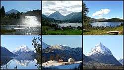 Views of Gloppen | |
 Coat of arms  Vestland within Norway | |
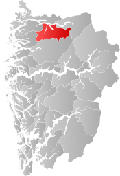 Gloppen within Vestland | |
| Coordinates: 61°44′38″N 06°10′14″E | |
| Country | Norway |
| County | Vestland |
| District | Nordfjord |
| Established | 1 Jan 1838 |
| Administrative centre | Sandane |
| Government | |
| • Mayor (2015) | Leidulf Gloppestad (Sp) |
| Area | |
| • Total | 1,030.57 km2 (397.91 sq mi) |
| • Land | 962.98 km2 (371.81 sq mi) |
| • Water | 67.59 km2 (26.10 sq mi) 6.6% |
| Area rank | 112 in Norway |
| Population (2020) | |
| • Total | 5,854 |
| • Rank | 162 in Norway |
| • Density | 6.1/km2 (16/sq mi) |
| • Change (10 years) | 2.8% |
| Demonym(s) | Gloppar[1] |
| Time zone | UTC+01:00 (CET) |
| • Summer (DST) | UTC+02:00 (CEST) |
| ISO 3166 code | NO-4650 |
| Official language form | Nynorsk[2] |
| Website | gloppen |
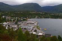
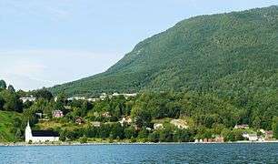
Each of the areas have their own main service centres. Sandane, the administrative centre of the municipality, is the largest with about 2,500 inhabitants. Sandane, Vereide, and Sørstranda are centered on the Gloppefjorden in Gloppen in the central part of the municipality. The villages of Byrkjelo, Re, Kandal, and Egge are centered on the lake Breimsvatnet in the Breim area in the east. The villages of Straume, Eimhjellen, and Solheim are located around the Hyefjorden in Hyen in the west. The whole municipality sits on the southern side of the large Nordfjorden.
The European route E39 highway runs through the municipality before crossing the Nordfjorden on a car ferry. The Sandane Airport, Anda is located along the E39 highway, just north of Vereide.
The 1,031-square-kilometre (398 sq mi) municipality is the 112th largest by area out of the 356 municipalities in Norway. Gloppen is the 162nd most populous municipality in Norway with a population of 5,854. The municipality's population density is 6.1 inhabitants per square kilometre (16/sq mi) and its population has increased by 2.8% over the previous 10-year period.[3][4]
General information
Gloppen was established as a municipality on 1 January 1838 (see formannskapsdistrikt law). The original municipality was identical to the Gloppen parish (prestegjeld) including the sub-parishes (sokn) of Gimmestad, Breim, and Vereide. On 1 January 1886, the sub-parish of Breim (population: 1,823) was separated from Gloppen to form its own municipality. This left Gloppen with 2,970 residents.[5]
During the 1960s, there were many municipal mergers across Norway due to the work of the Schei Committee. On 1 January 1964, the municipality of Breim (population: 1,731) was merged back into the municipality of Gloppen. After the merger, the population of Gloppen was 5,702. On 1 January 1965, the Hoplandsgrenda area (population: 42) of Gloppen municipality (on the northern shore of the Nordfjorden) was transferred to neighboring Stryn Municipality. On 1 January 1992, the Lote area of Gloppen (also on the north side of the Nordfjorden) was transferred to Eid Municipality. This left all of Gloppen located south of the Nordfjorden.[5]
On 1 January 2020, the municipality became part of the newly created Vestland county after Sogn og Fjordane and Hordaland counties were merged.
Name
The name (Old Norse: Gloppi) was originally the name of a fjord (now Gloppefjorden). The name is probably derived from the word gloppa which means "narrow opening".[6]
Coat of arms
The municipal coat of arms was granted on 19 December 1986. It shows a silver-colored fjord horse on a blue background. This was chosen since these horses are bred in the area.[7]
Churches
The Church of Norway has four parishes (sokn) within the municipality of Gloppen. It is part of the Nordfjord prosti (deanery) in the Diocese of Bjørgvin.
| Parish (sokn) | Church name | Location of the church | Year built |
|---|---|---|---|
| Breim | Breim Church | Re | 1886 |
| Gimmestad | Gimmestad Church | Sørstranda | 1910 |
| Old Gimmestad Church | Sørstranda | 1690 | |
| Hyen | Hyen Church | Straume | 1876 |
| Vereide | Sandane Church | Sandane | 1997 |
| Vereide Church | Vereide | 12th century |
Government
All municipalities in Norway, including Gloppen, are responsible for primary education (through 10th grade), outpatient health services, senior citizen services, unemployment and other social services, zoning, economic development, and municipal roads. The municipality is governed by a municipal council of elected representatives, which in turn elect a mayor.[8] The municipality falls under the Sogn og Fjordane District Court and the Gulating Court of Appeal.
Municipal council
The municipal council (Kommunestyre) of Gloppen is made up of 27 representatives that are elected to four year terms. The party breakdown of the council is as follows:
| Party Name (in Nynorsk) | Number of representatives | |
|---|---|---|
| Labour Party (Arbeidarpartiet) | 3 | |
| Green Party (Miljøpartiet Dei Grøne) | 2 | |
| Conservative Party (Høgre) | 2 | |
| Christian Democratic Party (Kristeleg Folkeparti) | 4 | |
| Centre Party (Senterpartiet) | 13 | |
| Socialist Left Party (Sosialistisk Venstreparti) | 1 | |
| Liberal Party (Venstre) | 1 | |
| Social Democrats (Samfunnsdemokratane) | 1 | |
| Total number of members: | 27 | |
| Party Name (in Nynorsk) | Number of representatives | |
|---|---|---|
| Labour Party (Arbeidarpartiet) | 2 | |
| Green Party (Miljøpartiet Dei Grøne) | 1 | |
| Conservative Party (Høgre) | 2 | |
| Christian Democratic Party (Kristeleg Folkeparti) | 7 | |
| Centre Party (Senterpartiet) | 11 | |
| Socialist Left Party (Sosialistisk Venstreparti) | 1 | |
| Liberal Party (Venstre) | 1 | |
| Social Democrats (Samfunnsdemokratane) | 2 | |
| Total number of members: | 27 | |
| Party Name (in Nynorsk) | Number of representatives | |
|---|---|---|
| Labour Party (Arbeidarpartiet) | 3 | |
| Conservative Party (Høgre) | 5 | |
| Christian Democratic Party (Kristeleg Folkeparti) | 3 | |
| Centre Party (Senterpartiet) | 9 | |
| Socialist Left Party (Sosialistisk Venstreparti) | 1 | |
| Liberal Party (Venstre) | 2 | |
| Social Democrats (Samfunnsdemokratane) | 4 | |
| Total number of members: | 27 | |
| Party Name (in Nynorsk) | Number of representatives | |
|---|---|---|
| Labour Party (Arbeidarpartiet) | 3 | |
| Progress Party (Framstegspartiet) | 1 | |
| Conservative Party (Høgre) | 4 | |
| Christian Democratic Party (Kristeleg Folkeparti) | 3 | |
| Centre Party (Senterpartiet) | 13 | |
| Socialist Left Party (Sosialistisk Venstreparti) | 2 | |
| Liberal Party (Venstre) | 1 | |
| Total number of members: | 27 | |
| Party Name (in Nynorsk) | Number of representatives | |
|---|---|---|
| Labour Party (Arbeidarpartiet) | 3 | |
| Progress Party (Framstegspartiet) | 1 | |
| Conservative Party (Høgre) | 3 | |
| Christian Democratic Party (Kristeleg Folkeparti) | 3 | |
| Centre Party (Senterpartiet) | 13 | |
| Socialist Left Party (Sosialistisk Venstreparti) | 3 | |
| Liberal Party (Venstre) | 1 | |
| Total number of members: | 27 | |
| Party Name (in Nynorsk) | Number of representatives | |
|---|---|---|
| Labour Party (Arbeidarpartiet) | 4 | |
| Conservative Party (Høgre) | 5 | |
| Christian Democratic Party (Kristeleg Folkeparti) | 7 | |
| Centre Party (Senterpartiet) | 12 | |
| Socialist Left Party (Sosialistisk Venstreparti) | 2 | |
| Liberal Party (Venstre) | 3 | |
| Total number of members: | 33 | |
| Party Name (in Nynorsk) | Number of representatives | |
|---|---|---|
| Labour Party (Arbeidarpartiet) | 5 | |
| Conservative Party (Høgre) | 3 | |
| Christian Democratic Party (Kristeleg Folkeparti) | 5 | |
| Centre Party (Senterpartiet) | 15 | |
| Socialist Left Party (Sosialistisk Venstreparti) | 2 | |
| Liberal Party (Venstre) | 3 | |
| Total number of members: | 33 | |
| Party Name (in Nynorsk) | Number of representatives | |
|---|---|---|
| Labour Party (Arbeidarpartiet) | 4 | |
| Conservative Party (Høgre) | 4 | |
| Christian Democratic Party (Kristeleg Folkeparti) | 6 | |
| Centre Party (Senterpartiet) | 15 | |
| Socialist Left Party (Sosialistisk Venstreparti) | 2 | |
| Liberal Party (Venstre) | 2 | |
| Total number of members: | 33 | |
| Party Name (in Nynorsk) | Number of representatives | |
|---|---|---|
| Labour Party (Arbeidarpartiet) | 5 | |
| Conservative Party (Høgre) | 6 | |
| Christian Democratic Party (Kristeleg Folkeparti) | 5 | |
| Centre Party (Senterpartiet) | 13 | |
| Liberal Party (Venstre) | 3 | |
| Socialist Common List (Sosialistisk Samlingsliste) | 1 | |
| Total number of members: | 33 | |
| Party Name (in Nynorsk) | Number of representatives | |
|---|---|---|
| Labour Party (Arbeidarpartiet) | 5 | |
| Conservative Party (Høgre) | 6 | |
| Christian Democratic Party (Kristeleg Folkeparti) | 6 | |
| Centre Party (Senterpartiet) | 12 | |
| Liberal Party (Venstre) | 3 | |
| Socialist Common List (Sosialistisk Samlingsliste) | 1 | |
| Total number of members: | 33 | |
| Party Name (in Nynorsk) | Number of representatives | |
|---|---|---|
| Labour Party (Arbeidarpartiet) | 3 | |
| Conservative Party (Høgre) | 5 | |
| Christian Democratic Party (Kristeleg Folkeparti) | 6 | |
| Centre Party (Senterpartiet) | 8 | |
| Liberal Party (Venstre) | 3 | |
| Breim's List (Breim si liste) | 8 | |
| Total number of members: | 33 | |
| Party Name (in Nynorsk) | Number of representatives | |
|---|---|---|
| Labour Party (Arbeidarpartiet) | 3 | |
| Conservative Party (Høgre) | 2 | |
| Christian Democratic Party (Kristeleg Folkeparti) | 6 | |
| New People's Party (Nye Folkepartiet) | 1 | |
| Centre Party (Senterpartiet) | 11 | |
| Liberal Party (Venstre) | 2 | |
| Local list for Inner Breim (Krinsliste for Indre Breim) | 5 | |
| Local list for Lower Breim (Krinsliste for Nedre Breim) | 3 | |
| Total number of members: | 33 | |
| Party Name (in Nynorsk) | Number of representatives | |
|---|---|---|
| Labour Party (Arbeidarpartiet) | 4 | |
| Conservative Party (Høgre) | 2 | |
| Christian Democratic Party (Kristeleg Folkeparti) | 4 | |
| Centre Party (Senterpartiet) | 11 | |
| Liberal Party (Venstre) | 4 | |
| Local List(s) (Lokale lister) | 8 | |
| Total number of members: | 33 | |
| Party Name (in Nynorsk) | Number of representatives | |
|---|---|---|
| Labour Party (Arbeidarpartiet) | 4 | |
| Conservative Party (Høgre) | 2 | |
| Christian Democratic Party (Kristeleg Folkeparti) | 3 | |
| Centre Party (Senterpartiet) | 11 | |
| Liberal Party (Venstre) | 4 | |
| Local List(s) (Lokale lister) | 9 | |
| Total number of members: | 33 | |
| Party Name (in Nynorsk) | Number of representatives | |
|---|---|---|
| Labour Party (Arbeidarpartiet) | 4 | |
| Conservative Party (Høgre) | 1 | |
| Christian Democratic Party (Kristeleg Folkeparti) | 4 | |
| Centre Party (Senterpartiet) | 17 | |
| Liberal Party (Venstre) | 5 | |
| Local List(s) (Lokale lister) | 2 | |
| Total number of members: | 33 | |
| Party Name (in Nynorsk) | Number of representatives | |
|---|---|---|
| Labour Party (Arbeidarpartiet) | 4 | |
| Conservative Party (Høgre) | 1 | |
| Christian Democratic Party (Kristeleg Folkeparti) | 3 | |
| Centre Party (Senterpartiet) | 13 | |
| Liberal Party (Venstre) | 7 | |
| Local List(s) (Lokale lister) | 1 | |
| Total number of members: | 29 | |
| Party Name (in Nynorsk) | Number of representatives | |
|---|---|---|
| Labour Party (Arbeidarpartiet) | 5 | |
| Conservative Party (Høgre) | 2 | |
| Christian Democratic Party (Kristeleg Folkeparti) | 3 | |
| Farmers' Party (Bondepartiet) | 13 | |
| Liberal Party (Venstre) | 6 | |
| Total number of members: | 29 | |
| Party Name (in Nynorsk) | Number of representatives | |
|---|---|---|
| Labour Party (Arbeidarpartiet) | 5 | |
| Conservative Party (Høgre) | 2 | |
| Farmers' Party (Bondepartiet) | 12 | |
| Liberal Party (Venstre) | 10 | |
| Total number of members: | 29 | |
| Party Name (in Nynorsk) | Number of representatives | |
|---|---|---|
| Labour Party (Arbeidarpartiet) | 3 | |
| Farmers' Party (Bondepartiet) | 5 | |
| Liberal Party (Venstre) | 5 | |
| Local List(s) (Lokale lister) | 16 | |
| Total number of members: | 29 | |
| Party Name (in Nynorsk) | Number of representatives | |
|---|---|---|
| Labour Party (Arbeidarpartiet) | 3 | |
| Local List(s) (Lokale lister) | 26 | |
| Total number of members: | 29 | |
| Party Name (in Nynorsk) | Number of representatives | |
|---|---|---|
| Labour Party (Arbeidarpartiet) | 5 | |
| Liberal Party (Venstre) | 2 | |
| Joint List(s) of Non-Socialist Parties (Borgarlege Felleslister) | 13 | |
| Local List(s) (Lokale lister) | 9 | |
| Total number of members: | 29 | |
Mayor
The mayor (ordførar) of a municipality in Norway is a representative of the majority party of the municipal council who is elected to lead the council.
The mayors of Gloppen (incomplete list):
- 2015–present: Leidulf Gloppestad (Sp)
- 1999-2015: Anders Ryssdal (Sp)
- 1988-1999: Nils R. Sandal (Sp)
- 1976-1988: Olav Moritsgård (Sp)
- 1968-1975: Ola M. Hestenes (Sp)
Geography
The municipality is located southern shores of the Nordfjorden. To the north is the municipality of Eid, to the east is Stryn, to the south is Naustdal and Jølster, and to the west is Flora and Bremanger. There are two fjords that branch off the main fjord into Gloppen: Hyefjorden and Gloppefjorden.
Gloppen has a natural landscape with virtually unspoiled nature ranging from sea level up to high-alpine mountains of some 1,800 metres (5,900 ft) height. Snønipa is the highest mountain in the municipality and is located at the Myklebustbreen glacier. The lakes Breimsvatn and Emhjellevatnet are, respectively, the first and second largest lakes in Gloppen. There are also some large glaciers such as Ålfotbreen, Gjegnalundsbreen, and Myklebustbreen. The river Gloppeelva runs from the lake Breimsvatnet to the Gloppefjorden.

 Breimsvatnet lake
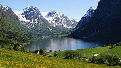 Myklebustdalen valley east of Byrkjelo
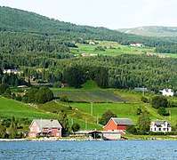 Karnilshaugen from Gloppefjorden
Economy
The dominant trades and industries in Gloppen are agriculture and farming. The municipal centre Sandane is also home to a college of secondary education and a branch of Sogn og Fjordane University College which specialized in music therapy (this school closed in 2005). The Firda Upper Secondary School is located in Sandane.
Attractions
Karnilshaugen
Gloppen is the site of Karnils tumulus burial mound (Norwegian: Karnilshaugen) from the Old Norse word haugr meaning mound or barrow. Karnilshaugen or Tinghaugen på Hauge is located on the Hauge farm west of Sandane. Karnilshaugen is probably one of the ten largest mounds in Nordfjord. The burial mound was built on top of Tinghaug, the site of a Thing (assembly). Tinghaug was a place of public gathering, for cultural events and religious actions.[27][28]
References
- "Navn på steder og personer: Innbyggjarnamn" (in Norwegian). Språkrådet.
- "Forskrift om målvedtak i kommunar og fylkeskommunar" (in Norwegian). Lovdata.no.
- Statistisk sentralbyrå (2020). "Table: 06913: Population 1 January and population changes during the calendar year (M)" (in Norwegian).
- Statistisk sentralbyrå (2020). "09280: Area of land and fresh water (km²) (M)" (in Norwegian).
- Jukvam, Dag (1999). "Historisk oversikt over endringer i kommune- og fylkesinndelingen" (PDF) (in Norwegian). Statistics Norway.
- Rygh, Oluf (1919). Norske gaardnavne: Nordre Bergenhus amt (in Norwegian) (12 ed.). Kristiania, Norge: W. C. Fabritius & sønners bogtrikkeri. p. 455.
- "Civic heraldry of Norway - Norske Kommunevåpen". Heraldry of the World. Retrieved 2017-10-22.
- Hansen, Tore, ed. (2016-05-12). "kommunestyre". Store norske leksikon (in Norwegian). Kunnskapsforlaget. Retrieved 2019-04-06.
- "Tall for Norge: Kommunestyrevalg 2019 - Vestland". Valg Direktoratet. Retrieved 2019-10-29.
- "Table: 04813: Members of the local councils, by party/electoral list at the Municipal Council election (M)" (in Norwegian). Statistics Norway.
- "Tall for Norge: Kommunestyrevalg 2011 - Sogn og Fjordane". Valg Direktoratet. Retrieved 2019-10-29.
- "Kommunestyrevalget 1995" (PDF) (in Norwegian). Oslo-Kongsvinger: Statistisk sentralbyrå. 1996. Retrieved 2020-02-18.
- "Kommunestyrevalget 1991" (PDF) (in Norwegian). Oslo-Kongsvinger: Statistisk sentralbyrå. 1993. Retrieved 2020-02-18.
- "Kommunestyrevalget 1987" (PDF) (in Norwegian). Oslo-Kongsvinger: Statistisk sentralbyrå. 1988. Retrieved 2020-02-18.
- "Kommunestyrevalget 1983" (PDF) (in Norwegian). Oslo-Kongsvinger: Statistisk sentralbyrå. 1984. Retrieved 2020-02-18.
- "Kommunestyrevalget 1979" (PDF) (in Norwegian). Oslo: Statistisk sentralbyrå. 1979. Retrieved 2020-02-18.
- "Kommunevalgene 1975" (PDF) (in Norwegian). Oslo: Statistisk sentralbyrå. 1977. Retrieved 2020-05-01.
- "Kommunevalgene 1972" (PDF) (in Norwegian). Oslo: Statistisk sentralbyrå. 1973. Retrieved 2020-05-01.
- "Kommunevalgene 1967" (PDF) (in Norwegian). Oslo: Statistisk sentralbyrå. 1967. Retrieved 2020-05-01.
- "Kommunevalgene 1963" (PDF) (in Norwegian). Oslo: Statistisk sentralbyrå. 1964. Retrieved 2020-05-01.
- "Kommunevalgene og Ordførervalgene 1959" (PDF) (in Norwegian). Oslo: Statistisk sentralbyrå. 1960. Retrieved 2020-05-01.
- "Kommunevalgene og Ordførervalgene 1955" (PDF) (in Norwegian). Oslo: Statistisk sentralbyrå. 1957. Retrieved 2020-05-01.
- "Kommunevalgene og Ordførervalgene 1951" (PDF) (in Norwegian). Oslo: Statistisk sentralbyrå. 1952. Retrieved 2020-05-01.
- "Kommunevalgene og Ordførervalgene 1947" (PDF) (in Norwegian). Oslo: Statistisk sentralbyrå. 1948. Retrieved 2020-05-01.
- "Kommunevalgene og Ordførervalgene 1945" (PDF) (in Norwegian). Oslo: Statistisk sentralbyrå. 1947. Retrieved 2020-05-01.
- "Kommunevalgene og Ordførervalgene 1937" (PDF) (in Norwegian). Oslo: Statistisk sentralbyrå. 1938. Retrieved 2020-05-01.
- Informasjonstavle i Karnilstunet, ved Karnilshaugen (Satt opp av «Stiftelsen Karnilstunet». 2001)
- Karnilshaugen på gården Hauge i Sandane, Gloppen, Norge (Solverv)
Other sources
- Sandal, Per (1992). Soga om Gloppen og Breim. III. ISBN 82-992720-0-9.
External links
- Municipal fact sheet from Statistics Norway (in Norwegian)
- Google Maps: Gloppen
- Official travel guide to Gloppen and the Nordfjord region
- Gloppen Guide 2008
 |
|  | |||
| Authority control |
|---|