Etne
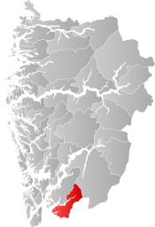
Etne is a municipality in Vestland county, Norway. It is located in the traditional district of Sunnhordland, although it is also sometimes considered to be part of the district of Haugaland. The administrative centre of the municipality is the village of Etnesjøen. Other villages in the municipality include Skånevik and Fjæra. The two largest villages in the municipality are Etnesjøen with 1,159 residents and Skånevik with 594 residents (all figures from 1 January 2015).[3][4]
Etne kommune | |
|---|---|
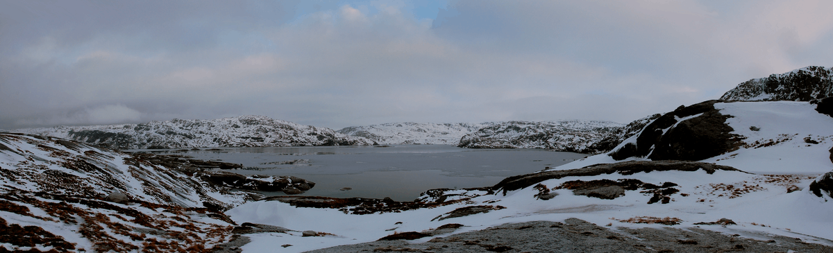 View of the lake Løkjelsvatnet in Etne | |
 Coat of arms  Vestland within Norway | |
 Etne within Vestland | |
| Coordinates: 59°39′50″N 05°56′00″E | |
| Country | Norway |
| County | Vestland |
| District | Sunnhordland |
| Established | 1 Jan 1838 |
| Administrative centre | Etnesjøen |
| Government | |
| • Mayor (2019) | Mette Heidi Bergsvåg Ekrheim (Sp) |
| Area | |
| • Total | 735.28 km2 (283.89 sq mi) |
| • Land | 691.16 km2 (266.86 sq mi) |
| • Water | 44.12 km2 (17.03 sq mi) 6% |
| Area rank | 154 in Norway |
| Population (2020) | |
| • Total | 4,062 |
| • Rank | 200 in Norway |
| • Density | 5.9/km2 (15/sq mi) |
| • Change (10 years) | 4.6% |
| Demonym(s) | Etnebu Etnesbu[1] |
| Time zone | UTC+01:00 (CET) |
| • Summer (DST) | UTC+02:00 (CEST) |
| ISO 3166 code | NO-4611 |
| Official language form | Nynorsk[2] |
| Website | etne |
The 735-square-kilometre (284 sq mi) municipality is the 154th largest by area out of the 356 municipalities in Norway. Etne is the 200th most populous municipality in Norway with a population of 4,062. The municipality's population density is 5.9 inhabitants per square kilometre (15/sq mi) and its population has increased by 4.6% over the previous 10-year period.[5][6]
Etne is situated south of the city of Bergen and it borders the municipalities of Kvinnherad, Ullensvang, Sauda, Suldal, and Vindafjord, the latter three are located in the neighboring county of Rogaland.
A Norwegian motion picture called United was shot in Etne with local people as actors.
General information

Etne was established as a municipality on 1 January 1838 (see formannskapsdistrikt law). Originally, Etne encompassed the area around the Etnefjorden and the surrounding valleys. During the 1960s, there were many municipal mergers across Norway due to the work of the Schei Committee. On 1 January 1965, the neighboring municipality of Skånevik was dissolved and merged into its neighboring municipalities. All of Skånevik located south of the Åkrafjorden and east of the village of Åkra on the north side of the fjord (population: 1,493) was merged into Etne.[7]
Name
The municipality is named after the Etnefjorden (Old Norse: Eðni). The fjord is probably named after an old river name Etna (now called the "Etneelvi").[8]
Coat of arms
The coat of arms was granted on 16 December 1983. The arms are blue on the left and silver/white on the right with a dovetailed line vertically down the middle. They represent the strong unity between the two former municipalities of Skånevik and Etne that were joined together to form one municipality in 1965.[9]
Churches
The Church of Norway has two parishes (sokn) within the municipality of Etne. It is part of the Sunnhordland prosti (deanery) in the Diocese of Bjørgvin.
| Parish (sokn) | Church name | Location of the church | Year built |
|---|---|---|---|
| Etne | Gjerde Church | Etnesjøen | 1676 |
| Grindheim Church | Etnesjøen | 1728 | |
| Stødle Church | Etnesjøen | 1160 | |
| Skånevik | Skånevik Church | Skånevik | 1900 |
| Fjæra Chapel | Fjæra | 1913 |
Geography
| Historical population | ||
|---|---|---|
| Year | Pop. | ±% |
| 1951 | 2,452 | — |
| 1960 | 2,512 | +2.4% |
| 1970 | 3,930 | +56.4% |
| 1980 | 3,980 | +1.3% |
| 1990 | 4,037 | +1.4% |
| 2000 | 3,917 | −3.0% |
| 2010 | 3,882 | −0.9% |
| 2019 | 4,077 | +5.0% |
| Source: Statistics Norway. | ||
Etne is situated south of the city of Bergen and it borders the municipalities of Kvinnherad and Ullensvang in Vestland county and the municipalities of Sauda, Suldal, and Vindafjord in Rogaland county.
Etne has a varied landscape, extending from the Etnefjorden, Skånevikfjorden, and Åkrafjorden at sea level, through the villages up to the high mountains. In the far north, there is a barren and heavily eroded mountain glacier, Folgefonna, where the municipality's highest point rises 1,638 metres (5,374 ft) above sea level. Folgefonna National Park is partially located in Etne. In addition to that national park, Etne has three nature reserves: Brattholmen, Skåno, and Langebudalen. Lakes in the area include Løkjelsvatnet. The famous waterfall Langfossen is located in northern Etne.[10]
History
Recent archeological findings indicate that the area was already inhabited around 500 BC.[11]
Government
All municipalities in Norway, including Etne, are responsible for primary education (through 10th grade), outpatient health services, senior citizen services, unemployment and other social services, zoning, economic development, and municipal roads. The municipality is governed by a municipal council of elected representatives, which in turn elect a mayor.[12] The municipality falls under the Haugesund District Court and the Gulating Court of Appeal.
Municipal council
The municipal council (Kommunestyre) of Etne is made up of 17 representatives that are elected to four year terms. The party breakdown of the council is as follows:
| Party Name (in Nynorsk) | Number of representatives | |
|---|---|---|
| Labour Party (Arbeidarpartiet) | 2 | |
| Progress Party (Framstegspartiet) | 4 | |
| Conservative Party (Høgre) | 1 | |
| Christian Democratic Party (Kristeleg Folkeparti) | 2 | |
| Centre Party (Senterpartiet) | 7 | |
| Liberal Party (Venstre) | 1 | |
| Total number of members: | 17 | |
| Party Name (in Nynorsk) | Number of representatives | |
|---|---|---|
| Labour Party (Arbeidarpartiet) | 5 | |
| Progress Party (Framstegspartiet) | 4 | |
| Conservative Party (Høgre) | 3 | |
| Christian Democratic Party (Kristeleg Folkeparti) | 2 | |
| Centre Party (Senterpartiet) | 6 | |
| Liberal Party (Venstre) | 1 | |
| Total number of members: | 21 | |
| Party Name (in Nynorsk) | Number of representatives | |
|---|---|---|
| Labour Party (Arbeidarpartiet) | 6 | |
| Progress Party (Framstegspartiet) | 3 | |
| Conservative Party (Høgre) | 3 | |
| Christian Democratic Party (Kristeleg Folkeparti) | 2 | |
| Centre Party (Senterpartiet) | 6 | |
| Liberal Party (Venstre) | 1 | |
| Total number of members: | 21 | |
| Party Name (in Nynorsk) | Number of representatives | |
|---|---|---|
| Labour Party (Arbeidarpartiet) | 4 | |
| Progress Party (Framstegspartiet) | 3 | |
| Conservative Party (Høgre) | 6 | |
| Christian Democratic Party (Kristeleg Folkeparti) | 3 | |
| Centre Party (Senterpartiet) | 3 | |
| Liberal Party (Venstre) | 1 | |
| Local list (Krinslista) | 1 | |
| Total number of members: | 21 | |
| Party Name (in Nynorsk) | Number of representatives | |
|---|---|---|
| Labour Party (Arbeidarpartiet) | 4 | |
| Progress Party (Framstegspartiet) | 2 | |
| Conservative Party (Høgre) | 5 | |
| Christian Democratic Party (Kristeleg Folkeparti) | 4 | |
| Centre Party (Senterpartiet) | 3 | |
| Liberal Party (Venstre) | 1 | |
| Local list (Krinslista) | 2 | |
| Total number of members: | 21 | |
| Party Name (in Nynorsk) | Number of representatives | |
|---|---|---|
| Labour Party (Arbeidarpartiet) | 5 | |
| Conservative Party (Høgre) | 5 | |
| Christian Democratic Party (Kristeleg Folkeparti) | 4 | |
| Centre Party (Senterpartiet) | 7 | |
| Liberal Party (Venstre) | 3 | |
| Etne local list (Etne bygdeliste) | 2 | |
| Local list for Skånevik (Krinsliste for Skånevik) | 3 | |
| Total number of members: | 29 | |
| Party Name (in Nynorsk) | Number of representatives | |
|---|---|---|
| Labour Party (Arbeidarpartiet) | 6 | |
| Conservative Party (Høgre) | 4 | |
| Christian Democratic Party (Kristeleg Folkeparti) | 5 | |
| Centre Party (Senterpartiet) | 9 | |
| Liberal Party (Venstre) | 1 | |
| Etne local list (Etne bygdeliste) | 1 | |
| Local list for Skånevik (Krinsliste for Skånevik) | 3 | |
| Total number of members: | 29 | |
| Party Name (in Nynorsk) | Number of representatives | |
|---|---|---|
| Labour Party (Arbeidarpartiet) | 7 | |
| Progress Party (Framstegspartiet) | 1 | |
| Conservative Party (Høgre) | 6 | |
| Christian Democratic Party (Kristeleg Folkeparti) | 5 | |
| Centre Party (Senterpartiet) | 5 | |
| Liberal Party (Venstre) | 1 | |
| Etne local list (Etne bygdeliste) | 2 | |
| Local list for Skånevik (Krinsliste for Skånevik) | 2 | |
| Total number of members: | 29 | |
| Party Name (in Nynorsk) | Number of representatives | |
|---|---|---|
| Labour Party (Arbeidarpartiet) | 7 | |
| Progress Party (Framstegspartiet) | 1 | |
| Conservative Party (Høgre) | 5 | |
| Christian Democratic Party (Kristeleg Folkeparti) | 5 | |
| Centre Party (Senterpartiet) | 4 | |
| Liberal Party (Venstre) | 1 | |
| Non-party list (Upolitisk liste) | 2 | |
| Local list for Skånevik (Krinsliste for Skånevik) | 4 | |
| Total number of members: | 29 | |
| Party Name (in Nynorsk) | Number of representatives | |
|---|---|---|
| Labour Party (Arbeidarpartiet) | 6 | |
| Conservative Party (Høgre) | 5 | |
| Christian Democratic Party (Kristeleg Folkeparti) | 7 | |
| Centre Party (Senterpartiet) | 5 | |
| Liberal Party (Venstre) | 1 | |
| Non-party list (Upolitisk liste) | 1 | |
| Local list for Skånevik (Krinsliste for Skånevik) | 4 | |
| Total number of members: | 29 | |
| Party Name (in Nynorsk) | Number of representatives | |
|---|---|---|
| Labour Party (Arbeidarpartiet) | 7 | |
| Conservative Party (Høgre) | 4 | |
| Christian Democratic Party (Kristeleg Folkeparti) | 7 | |
| New People's Party (Nye Folkepartiet) | 1 | |
| Centre Party (Senterpartiet) | 7 | |
| Liberal Party (Venstre) | 1 | |
| Local list for Skånevik (Krinsliste for Skånevik) | 2 | |
| Total number of members: | 29 | |
| Party Name (in Nynorsk) | Number of representatives | |
|---|---|---|
| Labour Party (Arbeidarpartiet) | 8 | |
| Conservative Party (Høgre) | 4 | |
| Christian Democratic Party (Kristeleg Folkeparti) | 6 | |
| Centre Party (Senterpartiet) | 7 | |
| Liberal Party (Venstre) | 4 | |
| Total number of members: | 29 | |
| Party Name (in Nynorsk) | Number of representatives | |
|---|---|---|
| Labour Party (Arbeidarpartiet) | 9 | |
| Conservative Party (Høgre) | 4 | |
| Christian Democratic Party (Kristeleg Folkeparti) | 6 | |
| Centre Party (Senterpartiet) | 6 | |
| Liberal Party (Venstre) | 4 | |
| Total number of members: | 29 | |
| Party Name (in Nynorsk) | Number of representatives | |
|---|---|---|
| Labour Party (Arbeidarpartiet) | 7 | |
| Conservative Party (Høgre) | 3 | |
| Christian Democratic Party (Kristeleg Folkeparti) | 3 | |
| Centre Party (Senterpartiet) | 5 | |
| Liberal Party (Venstre) | 3 | |
| Total number of members: | 21 | |
| Party Name (in Nynorsk) | Number of representatives | |
|---|---|---|
| Labour Party (Arbeidarpartiet) | 7 | |
| Conservative Party (Høgre) | 2 | |
| Christian Democratic Party (Kristeleg Folkeparti) | 3 | |
| Centre Party (Senterpartiet) | 5 | |
| Liberal Party (Venstre) | 4 | |
| Total number of members: | 21 | |
| Party Name (in Nynorsk) | Number of representatives | |
|---|---|---|
| Labour Party (Arbeidarpartiet) | 6 | |
| Conservative Party (Høgre) | 2 | |
| Farmers' Party (Bondepartiet) | 7 | |
| Joint List(s) of Non-Socialist Parties (Borgarlege Felleslister) | 6 | |
| Total number of members: | 21 | |
| Party Name (in Nynorsk) | Number of representatives | |
|---|---|---|
| Labour Party (Arbeidarpartiet) | 7 | |
| Joint List(s) of Non-Socialist Parties (Borgarlege Felleslister) | 11 | |
| Local List(s) (Lokale lister) | 6 | |
| Total number of members: | 24 | |
| Party Name (in Nynorsk) | Number of representatives | |
|---|---|---|
| Labour Party (Arbeidarpartiet) | 7 | |
| Joint List(s) of Non-Socialist Parties (Borgarlege Felleslister) | 14 | |
| Local List(s) (Lokale lister) | 3 | |
| Total number of members: | 24 | |
| Party Name (in Nynorsk) | Number of representatives | |
|---|---|---|
| Labour Party (Arbeidarpartiet) | 7 | |
| Joint List(s) of Non-Socialist Parties (Borgarlege Felleslister) | 3 | |
| Local List(s) (Lokale lister) | 14 | |
| Total number of members: | 24 | |
| Party Name (in Nynorsk) | Number of representatives | |
|---|---|---|
| Labour Party (Arbeidarpartiet) | 6 | |
| Farmers' Party (Bondepartiet) | 11 | |
| Joint List(s) of Non-Socialist Parties (Borgarlege Felleslister) | 2 | |
| Local List(s) (Lokale lister) | 5 | |
| Total number of members: | 24 | |
Transportation
The European route E134 highway runs the length of the municipality connecting it to the city of Haugesund in the southwest and to Oslo in the east. The highway runs through Etnesjøen and then northeastwards along the Åkrafjorden before crossing into the neighboring municipality of Odda. There are many tunnels along the route, some quite long, including the Åkrafjord Tunnel, Fjæra Tunnel, Markhus Tunnel, and Rullestad Tunnel.
The Eintveitbrua is a bridge in rural Etne that is not connected to the road network. It is considered to be a bridge to nowhere.
Notable residents
- Magnus V of Norway (1156–1184), King during the Civil war era in Norway
- Erling Skakke (1115–1179), Norwegian Jarl during the 12th century
References
- "Navn på steder og personer: Innbyggjarnamn" (in Norwegian). Språkrådet.
- "Forskrift om målvedtak i kommunar og fylkeskommunar" (in Norwegian). Lovdata.no.
- Statistisk sentralbyrå (1 January 2013). "Urban settlements. Population and area, by municipality".
- Store norske leksikon. "Etne" (in Norwegian). Retrieved 2015-04-10.
- Statistisk sentralbyrå (2020). "Table: 06913: Population 1 January and population changes during the calendar year (M)" (in Norwegian).
- Statistisk sentralbyrå (2020). "09280: Area of land and fresh water (km²) (M)" (in Norwegian).
- Jukvam, Dag (1999). "Historisk oversikt over endringer i kommune- og fylkesinndelingen" (PDF) (in Norwegian). Statistisk sentralbyrå.
- Rygh, Oluf (1910). Norske gaardnavne: Søndre Bergenhus amt (in Norwegian) (11 ed.). Kristiania, Norge: W. C. Fabritius & sønners bogtrikkeri. p. 64.
- "Civic heraldry of Norway - Norske Kommunevåpen". Heraldry of the World. Retrieved 2020-02-02.
- "Point on the glacier". Hordaland fylke. Archived from the original on 2016-03-03. Retrieved 2011-04-09.
- "Dette funnet er sensasjonelt" (in Norwegian). NRK.
- Hansen, Tore, ed. (2016-05-12). "kommunestyre". Store norske leksikon (in Norwegian). Kunnskapsforlaget. Retrieved 2019-04-06.
- "Tall for Norge: Kommunestyrevalg 2019 - Vestland". Valg Direktoratet. Retrieved 2020-02-02.
- "Table: 04813: Members of the local councils, by party/electoral list at the Municipal Council election (M)" (in Norwegian). Statistics Norway.
- "Tall for Norge: Kommunestyrevalg 2011 - Hordaland". Valg Direktoratet. Retrieved 2020-02-02.
- "Kommunestyrevalget 1995" (PDF) (in Norwegian). Oslo-Kongsvinger: Statistisk sentralbyrå. 1996. Retrieved 2020-02-20.
- "Kommunestyrevalget 1991" (PDF) (in Norwegian). Oslo-Kongsvinger: Statistisk sentralbyrå. 1993. Retrieved 2020-02-20.
- "Kommunestyrevalget 1987" (PDF) (in Norwegian). Oslo-Kongsvinger: Statistisk sentralbyrå. 1988. Retrieved 2020-02-20.
- "Kommunestyrevalget 1983" (PDF) (in Norwegian). Oslo-Kongsvinger: Statistisk sentralbyrå. 1984. Retrieved 2020-02-20.
- "Kommunestyrevalget 1979" (PDF) (in Norwegian). Oslo: Statistisk sentralbyrå. 1979. Retrieved 2020-02-20.
- "Kommunevalgene 1975" (PDF) (in Norwegian). Oslo: Statistisk sentralbyrå. 1977. Retrieved 2020-05-10.
- "Kommunevalgene 1972" (PDF) (in Norwegian). Oslo: Statistisk sentralbyrå. 1973. Retrieved 2020-05-10.
- "Kommunevalgene 1967" (PDF) (in Norwegian). Oslo: Statistisk sentralbyrå. 1967. Retrieved 2020-05-10.
- "Kommunevalgene 1963" (PDF) (in Norwegian). Oslo: Statistisk sentralbyrå. 1964. Retrieved 2020-05-10.
- "Kommunevalgene og Ordførervalgene 1959" (PDF) (in Norwegian). Oslo: Statistisk sentralbyrå. 1960. Retrieved 2020-05-10.
- "Kommunevalgene og Ordførervalgene 1955" (PDF) (in Norwegian). Oslo: Statistisk sentralbyrå. 1957. Retrieved 2020-05-10.
- "Kommunevalgene og Ordførervalgene 1951" (PDF) (in Norwegian). Oslo: Statistisk sentralbyrå. 1952. Retrieved 2020-05-10.
- "Kommunevalgene og Ordførervalgene 1947" (PDF) (in Norwegian). Oslo: Statistisk sentralbyrå. 1948. Retrieved 2020-05-10.
- "Kommunevalgene og Ordførervalgene 1945" (PDF) (in Norwegian). Oslo: Statistisk sentralbyrå. 1947. Retrieved 2020-05-10.
- "Kommunevalgene og Ordførervalgene 1937" (PDF) (in Norwegian). Oslo: Statistisk sentralbyrå. 1938. Retrieved 2020-05-10.
External links
| Wikimedia Commons has media related to Etne. |


- Municipal fact sheet from Statistics Norway (in Norwegian)
- Pictures from Etne
 |
|  | |||
| Authority control |
|---|