Alver (municipality)
Alver is a municipality in Vestland county, Norway. It is located in the traditional district of Nordhordland. The administrative centre of the municipality is the village of Knarvik. Other villages include Alversund, Alver, Isdalstø, Lindås, Ostereidet, Seim, Manger, Askeland, Austmarka, Bøvågen, Haugland, Sæbø, Sletta, Frekhaug, Hjartås, Holme, Io, Krossneset, Meland, and Rossland.
Alver kommune | |
|---|---|
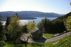 View of Veland along the Hindnesfjorden | |
 Coat of arms  Vestland within Norway | |
 Alver within Vestland | |
| Coordinates: 60°40′00″N 05°20′00″E | |
| Country | Norway |
| County | Vestland |
| District | Nordhordland |
| Established | 1 Jan 2020 |
| Administrative centre | Knarvik |
| Government | |
| • Mayor (2020) | Sara Hamre Sekkingstad (Sp) |
| Area | |
| • Total | 679.05 km2 (262.18 sq mi) |
| • Land | 650.50 km2 (251.16 sq mi) |
| • Water | 28.55 km2 (11.02 sq mi) 4.2% |
| Area rank | 168 in Norway |
| Population (2020) | |
| • Total | 29,224 |
| • Rank | 37 in Norway |
| • Density | 44.9/km2 (116/sq mi) |
| • Change (10 years) | 13.5% |
| Time zone | UTC+01:00 (CET) |
| • Summer (DST) | UTC+02:00 (CEST) |
| ISO 3166 code | NO-4631 |
| Official language form | Nynorsk[1] |
| Website | alver |
The 679-square-kilometre (262 sq mi) municipality is the 168th largest by area out of the 356 municipalities in Norway. Alver is the 37th most populous municipality in Norway with a population of 29,224. The municipality's population density is 44.6 inhabitants per square kilometre (116/sq mi) and its population has increased by 13.5% over the previous 10-year period.[2][3]
General information
The municipality was established on 1 January 2020 when the three neighboring municipalities of Lindås, Radøy, and Meland were merged into one large municipality.[4]
Name
The name of the municipality comes from the old Alver farm (Old Norse: Alviðra). The name has two parts "al" meaning "whole" and "viðra" meaning "weather", probably referring to the location which is exposed to the weather from all directions. mIt is the same root as the other local names like Alversund and Alverstraumen.[4][5][6]
Coat of arms
The coat of arms was adopted in 2019 for use starting in 2020. The blue arms show a gray or white bridge and a boat passing beneath it. It symbolizes that the fact that bridges tie the municipality together and the boat has been a means of transportation in the area for centuries.[7]
Churches
The Church of Norway has six parishes (sokn) within the municipality of Alver. It is part of the Nordhordland prosti (deanery) in the Diocese of Bjørgvin.
| Parish (sokn) | Church name | Location of the church | Year built |
|---|---|---|---|
| Knarvik | Alversund Church | Alversund | 1879 |
| Knarvik Church | Knarvik | 2014 | |
| Lygra Church | Luro | 1892 | |
| Seim Church | Seim | 1878 | |
| Lindås | Hundvin Church | Hundvin | 1936 |
| Lindås Church | Lindås | 1865 | |
| Myking Church | Myking | 1861 | |
| Meland | Meland Church | Meland | 1866 |
| Ostereidet | Ostereidet Church | Ostereidet | 1988 |
| Radøy | Hordabø Church | Bøvågen | 1875 |
| Manger Church | Manger | 1891 | |
| Sæbø Church | Sæbø | 1883 | |
| Emigrant Church, Sletta | Sletta | 1997 | |
| Vike | Vike Church | Vikanes | 1891 |
Government
All municipalities in Norway, including Alver, are responsible for primary education (through 10th grade), outpatient health services, senior citizen services, unemployment and other social services, zoning, economic development, and municipal roads. The municipality is governed by a municipal council of elected representatives, which in turn elects a mayor.[8] The municipality falls under the Bergen District Court and the Gulating Court of Appeal.
Municipal council
The municipal council (Kommunestyre) of Alver is made up of 47 representatives that are elected to four year terms. The party breakdown of the council is as follows:
| Party Name (in Nynorsk) | Number of representatives | |
|---|---|---|
| Labour Party (Arbeidarpartiet) | 7 | |
| People's Action No to More Road Tolls (Folkeaksjonen nei til meir bompengar) | 10 | |
| Progress Party (Framstegspartiet) | 3 | |
| Green Party (Miljøpartiet Dei Grøne) | 2 | |
| Conservative Party (Høgre) | 6 | |
| Christian Democratic Party (Kristeleg Folkeparti) | 7 | |
| Red Party (Raudt) | 1 | |
| Centre Party (Senterpartiet) | 8 | |
| Socialist Left Party (Sosialistisk Venstreparti) | 2 | |
| Liberal Party (Venstre) | 1 | |
| Total number of members: | 47 | |
References
- "Forskrift om målvedtak i kommunar og fylkeskommunar" (in Norwegian). Lovdata.no.
- Statistisk sentralbyrå (2020). "Table: 06913: Population 1 January and population changes during the calendar year (M)" (in Norwegian).
- Statistisk sentralbyrå (2020). "09280: Area of land and fresh water (km²) (M)" (in Norwegian).
- Thorsnæs, Geir, ed. (2020-01-20). "Alver". Store norske leksikon (in Norwegian). Kunnskapsforlaget. Retrieved 2020-02-02.
- "Kva og kvar" (in Norwegian). Kartverket. Retrieved 2020-02-02.
- Rygh, Oluf (1910). Norske gaardnavne: Søndre Bergenhus amt (in Norwegian) (11 ed.). Kristiania, Norge: W. C. Fabritius & sønners bogtrikkeri.
- Garen Svardal, Yngve (2018-09-04). "Kommunevåpenet til nye Alver kommune er klart". Nordhordland (in Norwegian). Retrieved 2020-02-02.
- Hansen, Tore, ed. (2016-05-12). "kommunestyre". Store norske leksikon (in Norwegian). Kunnskapsforlaget. Retrieved 2020-02-02.
- "Tall for Norge: Kommunestyrevalg 2019 - Vestland". Valg Direktoratet. Retrieved 2020-02-02.
 |
|  | |||