Modalen
Modalen is a municipality in the Nordhordland district in the central part of Vestland county in Norway. The administrative centre of the municipality is the village of Mo. The other main village in the municipality is Øvre Helland. Most of the residents of Modalen live in the main Modalen valley which extends eastwards from the end of the Romarheimsfjorden.
Modalen kommune | |
|---|---|
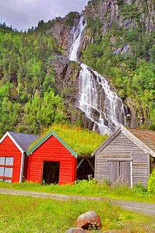
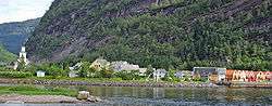 View of Mo in Modalen | |
 Coat of arms  Vestland within Norway | |
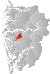 Modalen within Vestland | |
| Coordinates: 60°52′50″N 05°55′31″E | |
| Country | Norway |
| County | Vestland |
| District | Nordhordland |
| Established | 1 Jan 1910 |
| Administrative centre | Modalen |
| Government | |
| • Mayor (2019) | Kjetil Eikefet (LL) |
| Area | |
| • Total | 411.99 km2 (159.07 sq mi) |
| • Land | 379.07 km2 (146.36 sq mi) |
| • Water | 32.92 km2 (12.71 sq mi) 8% |
| Area rank | 236 in Norway |
| Population (2020) | |
| • Total | 388 |
| • Rank | 355 in Norway |
| • Density | 1.0/km2 (3/sq mi) |
| • Change (10 years) | 12.8% |
| Demonym(s) | Modøl[1] |
| Time zone | UTC+01:00 (CET) |
| • Summer (DST) | UTC+02:00 (CEST) |
| ISO 3166 code | NO-4629 |
| Official language form | Nynorsk[2] |
| Website | modalen |
The small population, combined with a large income from hydro-electric power production, has given the municipality the ability to give all its residents free wireless internet access in the municipality. They also were the first Norwegian municipality to buy a computer for all students in the municipality in 1993.
The 412-square-kilometre (159 sq mi) municipality is the 236th largest by area out of the 356 municipalities in Norway. Modalen is the 355th most populous municipality in Norway with a population of 388 (making it the second smallest municipality in Norway after Utsira). The municipality's population density is 1 inhabitant per square kilometre (2.6/sq mi) and its population has increased by 12.8% over the previous 10-year period.[3][4]
General information
The parish of Modalen was separated from the old municipality of Hosanger on 1 January 1910 to become a separate municipality. Initially, the municipality had 821 residents. During the 1960s, there were many municipal mergers across Norway due to the work of the Schei Committee. On 1 January 1964, the middle part of the Eksingedalen valley (population: 151) was transferred from Modalen to the municipality of Vaksdal. Also on that date, the Nipo, Dyrkolbotn, and Eitrdalen farm areas (population: 12), located north of the village of Romarheim, were transferred from Modalen to the neighboring municipality of Lindås.[5]
Name
The municipality (originally the parish) is named after the old Mo farm (Old Norse: Mór), since Mo Church was built there in the Middle Ages. The name is identical with the word mór which means "heath" or "moor". The last element -dalen (the finite form of dal which means "valley" or "dale") was added later.[6]
Coat of arms
The coat of arms was granted on 2 November 1984. The arms are green with three silver spades. The spades are a symbol for the agriculture and sand digging in the municipality, which historically were of great importance.[7]
Churches
The Church of Norway has one parish (sokn) within the municipality of Modalen. It is part of the Nordhordland prosti (deanery) in the Diocese of Bjørgvin.
| Parish (sokn) | Church name | Location of the church | Year built |
|---|---|---|---|
| Mo | Mo Church | Mo | 1883 |
| Historical population | ||
|---|---|---|
| Year | Pop. | ±% |
| 1951 | 627 | — |
| 1960 | 544 | −13.2% |
| 1970 | 295 | −45.8% |
| 1980 | 313 | +6.1% |
| 1990 | 340 | +8.6% |
| 2000 | 354 | +4.1% |
| 2010 | 344 | −2.8% |
| 2019 | 380 | +10.5% |
| Source: Statistics Norway. | ||
Government
All municipalities in Norway, including Modalen, are responsible for primary education (through 10th grade), outpatient health services, senior citizen services, unemployment and other social services, zoning, economic development, and municipal roads. The municipality is governed by a municipal council of elected representatives, which in turn elect a mayor.[8] The municipality falls under the Nordhordland District Court and the Gulating Court of Appeal.
Municipal council
The municipal council (Kommunestyre) of Modalen is made up of 13 representatives that are elected every four years. Modalen is the only municipality in Norway that has a non-partisan council, so all representatives run on local lists rather than by party.
| Party Name (in Nynorsk) | Number of representatives | |
|---|---|---|
| Samlingslista (Common List) | 7 | |
| Solrenningslista (Sunrise List) | 6 | |
| Total number of members: | 13 | |
| Party Name (in Nynorsk) | Number of representatives | |
|---|---|---|
| Samlingslista (Common List) | 6 | |
| Solrenningslista (Sunrise List) | 7 | |
| Total number of members: | 13 | |
| Party Name (in Nynorsk) | Number of representatives | |
|---|---|---|
| Samlingslista (Common List) | 7 | |
| Solrenningslista (Sunrise List) | 6 | |
| Total number of members: | 13 | |
| Party Name (in Nynorsk) | Number of representatives | |
|---|---|---|
| Samlingslista (Common List) | 5 | |
| Solrenningslista (Sunrise List) | 8 | |
| Total number of members: | 13 | |
| Party Name (in Nynorsk) | Number of representatives | |
|---|---|---|
| Samlingslista (Common List) | 8 | |
| Solrenningslista (Sunrise List) | 5 | |
| Total number of members: | 13 | |
| Party Name (in Nynorsk) | Number of representatives | |
|---|---|---|
| Common Election List (Flertallsvalg) | 13 | |
| Total number of members: | 13 | |
Mayor
The mayors of Modalen (incomplete list):
- 2019-present: Kjetil Eikefet (Bygdeliste)
- 2015-2019: Tom Kristian Thorsen (Bygdeliste)
- 2003-2015: Knut Moe (Bygdeliste)
Geography
Modalen municipality sits in the central part of Vestland county. It surrounds the innermost part of the Romarheimsfjorden (which is also called the Mofjorden) and the Modalen valley which extends eastwards from the end of the fjord. Both sides of the valley are mountainous, so the municipality is quite isolated with only two roads connecting it to the outside world. Both roads were constructed fairly recently, before that time, the municipality was only accessible by boat or crossing mountains on foot. The Modalen Tunnel was built in 1976 and it connects this valley to the Eksingedalen valley to the south. The other road was finished in 1996, and it follows the fjord heading west to Lindås.
The Modalen valley centers around the river Moelva. The lake Steinslandsvatnet, in the central part of the municipality, is the headwaters of the river. The high mountains that surround the valley provide many sources of hydroelectric power such as the lake Skjerjavatnet.
Modalen borders the municipality of Høyanger to the north and the municipality of Vik to the east, Vaksdal to the south, and Alver and Masfjorden to the west.
References
- "Navn på steder og personer: Innbyggjarnamn" (in Norwegian). Språkrådet.
- "Forskrift om målvedtak i kommunar og fylkeskommunar" (in Norwegian). Lovdata.no.
- Statistisk sentralbyrå (2020). "Table: 06913: Population 1 January and population changes during the calendar year (M)" (in Norwegian).
- Statistisk sentralbyrå (2020). "09280: Area of land and fresh water (km²) (M)" (in Norwegian).
- Jukvam, Dag (1999). "Historisk oversikt over endringer i kommune- og fylkesinndelingen" (PDF) (in Norwegian). Statistisk sentralbyrå.
- Rygh, Oluf (1919). Norske gaardnavne: Nordre Bergenhus amt (in Norwegian) (12 ed.). Kristiania, Norge: W. C. Fabritius & sønners bogtrikkeri. pp. 336–337.
- "Civic heraldry of Norway - Norske Kommunevåpen". Heraldry of the World. Retrieved 2020-02-02.
- Hansen, Tore, ed. (2016-05-12). "kommunestyre". Store norske leksikon (in Norwegian). Kunnskapsforlaget. Retrieved 2019-04-06.
- "Tall for Norge: Kommunestyrevalg 2019 - Vestland". Valg Direktoratet. Retrieved 2020-02-02.
- "Table: 04813: Members of the local councils, by party/electoral list at the Municipal Council election (M)" (in Norwegian). Statistics Norway.
- "Tall for Norge: Kommunestyrevalg 2011 - Hordaland". Valg Direktoratet. Retrieved 2020-02-02.
External links
| Wikimedia Commons has media related to Modalen. |
- Municipal fact sheet from Statistics Norway (in Norwegian)
 |
|  | |||