Samnanger
Samnanger (Urban East Norwegian: [ˈsɑ̂mnɑŋər]) is a municipality in the Midhordland region of Vestland county, Norway. The administrative centre of the municipality is the village of Tysse. Other main villages in the municipality include Haga and Bjørkheim in Nordbygda. The municipality is located about 20 kilometres (12 mi) east of the city of Bergen, Norway's second largest city. It surrounds the inner part of the Samnangerfjorden and the surrounding valleys. There are mountains that surround the municipality. The development of hydroelectric power plants started here in 1909.
Samnanger kommune | |
|---|---|
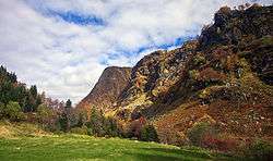 View of Kvittingen valley area | |
 Coat of arms  Vestland within Norway | |
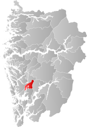 Samnanger within Vestland | |
| Coordinates: 60°24′10″N 05°48′20″E | |
| Country | Norway |
| County | Vestland |
| District | Midhordland |
| Established | 1 Jan 1907 |
| Administrative centre | Tysse |
| Government | |
| • Mayor (2015) | Knut Harald Frøland (Local list) |
| Area | |
| • Total | 269.07 km2 (103.89 sq mi) |
| • Land | 257.41 km2 (99.39 sq mi) |
| • Water | 11.66 km2 (4.50 sq mi) 4.3% |
| Area rank | 274 in Norway |
| Population (2020) | |
| • Total | 2,485 |
| • Rank | 254 in Norway |
| • Density | 9.7/km2 (25/sq mi) |
| • Change (10 years) | 4.6% |
| Demonym(s) | Samning[1] |
| Time zone | UTC+01:00 (CET) |
| • Summer (DST) | UTC+02:00 (CEST) |
| ISO 3166 code | NO-4623 |
| Official language form | Nynorsk[2] |
| Website | samnanger |
The 269-square-kilometre (104 sq mi) municipality is the 274th largest by area out of the 356 municipalities in Norway. Samnanger is the 254th most populous municipality in Norway with a population of 2,485. The municipality's population density is 9.7 inhabitants per square kilometre (25/sq mi) and its population has increased by 4.6% over the previous 10-year period.[3][4]
In 2016, the chief of police for Vestlandet formally suggested a reconfiguration of police districts and stations. He proposed that the police station in Samnanger be closed.[5]
General information

The municipality of Samnanger was established on 1 January 1907 when it was separated from the municipality of Os. Initially, Samnanger had 3,025 residents. The borders of the municipality have not changed since that time.[6]
Name
The name originally belonged to the fjord (now called the Samnangerfjorden). The meaning of the first element is unknown, and the last element is angr which means "fjord".[7]
Coat of arms
The coat of arms was granted on 27 April 1990. It shows six yellow drops of water on a red field. Water was chosen as a symbol on the arms because of the wet climate and the source of hydroelectricity that is prevalent in the area. The designer of the arms was Even Jarl Skoglund.[8]
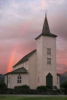
Churches
The Church of Norway has one parish (sokn) within the municipality of Samnanger. It is part of the Hardanger og Voss prosti (deanery) in the Diocese of Bjørgvin.
| Parish (sokn) | Church name | Location of the church | Year built |
|---|---|---|---|
| Samnanger | Haga Church | Haga | 1995 |
| Samnanger Church | Ådland | 1851 |
Government
All municipalities in Norway, including Samnanger, are responsible for primary education (through 10th grade), outpatient health services, senior citizen services, unemployment and other social services, zoning, economic development, and municipal roads. The municipality is governed by a municipal council of elected representatives, which in turn elect a mayor.[9] The municipality falls under the Bergen District Court and the Gulating Court of Appeal.
Municipal council
The municipal council (Kommunestyre) of Samnanger is made up of 21 representatives that are elected to four year terms. The party breakdown of the council is as follows:
| Party Name (in Nynorsk) | Number of representatives | |
|---|---|---|
| Labour Party (Arbeidarpartiet) | 4 | |
| Progress Party (Framstegspartiet) | 3 | |
| Green Party (Miljøpartiet Dei Grøne) | 2 | |
| Conservative Party (Høgre) | 1 | |
| Christian Democratic Party (Kristeleg Folkeparti) | 1 | |
| Centre Party (Senterpartiet) | 2 | |
| Local List (Bygdalista) | 8 | |
| Total number of members: | 21 | |
| Party Name (in Nynorsk) | Number of representatives | |
|---|---|---|
| Labour Party (Arbeidarpartiet) | 5 | |
| Progress Party (Framstegspartiet) | 4 | |
| Green Party (Miljøpartiet Dei Grøne) | 1 | |
| Conservative Party (Høgre) | 2 | |
| Christian Democratic Party (Kristeleg Folkeparti) | 2 | |
| Centre Party (Senterpartiet) | 2 | |
| Local List (Bygdalista) | 5 | |
| Total number of members: | 21 | |
| Party Name (in Nynorsk) | Number of representatives | |
|---|---|---|
| Labour Party (Arbeidarpartiet) | 6 | |
| Progress Party (Framstegspartiet) | 4 | |
| Conservative Party (Høgre) | 2 | |
| Christian Democratic Party (Kristeleg Folkeparti) | 4 | |
| Centre Party (Senterpartiet) | 2 | |
| Local List (Bygdalista) | 3 | |
| Total number of members: | 21 | |
| Party Name (in Nynorsk) | Number of representatives | |
|---|---|---|
| Labour Party (Arbeidarpartiet) | 6 | |
| Progress Party (Framstegspartiet) | 3 | |
| Conservative Party (Høgre) | 2 | |
| Christian Democratic Party (Kristeleg Folkeparti) | 5 | |
| Centre Party (Senterpartiet) | 2 | |
| Local List (Bygdalista) | 3 | |
| Total number of members: | 21 | |
| Party Name (in Nynorsk) | Number of representatives | |
|---|---|---|
| Labour Party (Arbeidarpartiet) | 7 | |
| Progress Party (Framstegspartiet) | 2 | |
| Conservative Party (Høgre) | 1 | |
| Christian Democratic Party (Kristeleg Folkeparti) | 4 | |
| Centre Party (Senterpartiet) | 3 | |
| Local List (Bygdalista) | 4 | |
| Total number of members: | 21 | |
| Party Name (in Nynorsk) | Number of representatives | |
|---|---|---|
| Labour Party (Arbeidarpartiet) | 7 | |
| Progress Party (Framstegspartiet) | 1 | |
| Conservative Party (Høgre) | 1 | |
| Christian Democratic Party (Kristeleg Folkeparti) | 5 | |
| Centre Party (Senterpartiet) | 2 | |
| Local List (Bygdalista) | 5 | |
| Total number of members: | 21 | |
| Party Name (in Nynorsk) | Number of representatives | |
|---|---|---|
| Labour Party (Arbeidarpartiet) | 9 | |
| Conservative Party (Høgre) | 2 | |
| Christian Democratic Party (Kristeleg Folkeparti) | 3 | |
| Centre Party (Senterpartiet) | 3 | |
| Local list (Bygdalista) | 4 | |
| Total number of members: | 21 | |
| Party Name (in Nynorsk) | Number of representatives | |
|---|---|---|
| Labour Party (Arbeidarpartiet) | 7 | |
| Progress Party (Framstegspartiet) | 1 | |
| Conservative Party (Høgre) | 2 | |
| Christian Democratic Party (Kristeleg Folkeparti) | 4 | |
| Local list (Bygdalista) | 3 | |
| Total number of members: | 17 | |
| Party Name (in Nynorsk) | Number of representatives | |
|---|---|---|
| Labour Party (Arbeidarpartiet) | 7 | |
| Conservative Party (Høgre) | 2 | |
| Christian Democratic Party (Kristeleg Folkeparti) | 4 | |
| Local list (Bygdalista) | 4 | |
| Total number of members: | 17 | |
| Party Name (in Nynorsk) | Number of representatives | |
|---|---|---|
| Labour Party (Arbeidarpartiet) | 7 | |
| Conservative Party (Høgre) | 2 | |
| Christian Democratic Party (Kristeleg Folkeparti) | 4 | |
| Local list (Bygdalista) | 4 | |
| Total number of members: | 17 | |
| Party Name (in Nynorsk) | Number of representatives | |
|---|---|---|
| Labour Party (Arbeidarpartiet) | 6 | |
| Conservative Party (Høgre) | 3 | |
| Christian Democratic Party (Kristeleg Folkeparti) | 4 | |
| Local list (Bygdalista) | 4 | |
| Total number of members: | 17 | |
| Party Name (in Nynorsk) | Number of representatives | |
|---|---|---|
| Labour Party (Arbeidarpartiet) | 7 | |
| Conservative Party (Høgre) | 2 | |
| Christian Democratic Party (Kristeleg Folkeparti) | 4 | |
| Local list for Samnanger (Bygdelista for Samnanger) | 4 | |
| Total number of members: | 17 | |
| Party Name (in Nynorsk) | Number of representatives | |
|---|---|---|
| Labour Party (Arbeidarpartiet) | 9 | |
| Conservative Party (Høgre) | 1 | |
| Christian Democratic Party (Kristeleg Folkeparti) | 3 | |
| Local List(s) (Lokale lister) | 4 | |
| Total number of members: | 17 | |
| Party Name (in Nynorsk) | Number of representatives | |
|---|---|---|
| Labour Party (Arbeidarpartiet) | 7 | |
| Conservative Party (Høgre) | 1 | |
| Christian Democratic Party (Kristeleg Folkeparti) | 4 | |
| Joint List(s) of Non-Socialist Parties (Borgarlege Felleslister) | 4 | |
| Local List(s) (Lokale lister) | 1 | |
| Total number of members: | 17 | |
| Party Name (in Nynorsk) | Number of representatives | |
|---|---|---|
| Labour Party (Arbeidarpartiet) | 6 | |
| Conservative Party (Høgre) | 1 | |
| Christian Democratic Party (Kristeleg Folkeparti) | 4 | |
| Local List(s) (Lokale lister) | 6 | |
| Total number of members: | 17 | |
| Party Name (in Nynorsk) | Number of representatives | |
|---|---|---|
| Labour Party (Arbeidarpartiet) | 4 | |
| Conservative Party (Høgre) | 1 | |
| Christian Democratic Party (Kristeleg Folkeparti) | 3 | |
| Local List(s) (Lokale lister) | 9 | |
| Total number of members: | 17 | |
| Party Name (in Nynorsk) | Number of representatives | |
|---|---|---|
| Labour Party (Arbeidarpartiet) | 5 | |
| Conservative Party (Høgre) | 2 | |
| Joint List(s) of Non-Socialist Parties (Borgarlege Felleslister) | 4 | |
| Local List(s) (Lokale lister) | 6 | |
| Total number of members: | 17 | |
| Party Name (in Nynorsk) | Number of representatives | |
|---|---|---|
| Labour Party (Arbeidarpartiet) | 6 | |
| Conservative Party (Høgre) | 1 | |
| Joint List(s) of Non-Socialist Parties (Borgarlege Felleslister) | 4 | |
| Local List(s) (Lokale lister) | 5 | |
| Total number of members: | 16 | |
| Party Name (in Nynorsk) | Number of representatives | |
|---|---|---|
| Labour Party (Arbeidarpartiet) | 5 | |
| Communist Party (Kommunistiske Parti) | 1 | |
| Local List(s) (Lokale lister) | 10 | |
| Total number of members: | 16 | |
| Party Name (in Nynorsk) | Number of representatives | |
|---|---|---|
| Labour Party (Arbeidarpartiet) | 5 | |
| Local List(s) (Lokale lister) | 11 | |
| Total number of members: | 16 | |
| Party Name (in Nynorsk) | Number of representatives | |
|---|---|---|
| Labour Party (Arbeidarpartiet) | 5 | |
| Joint List(s) of Non-Socialist Parties (Borgarlege Felleslister) | 10 | |
| Local List(s) (Lokale lister) | 1 | |
| Total number of members: | 16 | |
Mayor

The mayors of Samnanger (incomplete list):
- 2015–present: Knut Harald Frøland (LL)
- 1999-2015: Marit A. Aase (KrF)
- 1991-1999: Brigt Olav Gåsdal (Ap)
- 1982-1991: Brynjulv Hernes (KrF)
- 1980-1981: Knut N. Langeland (LL)
- 1978-1979: Martin K.Nilsen (Ap)
- 1976-1977: Knut N. Langeland (LL)
- 1972-1975: Martin K.Nilsen (Ap)
- 1968-1971: Ragnvald Brigsten (KrF)
- 1964-1967: Martin K.Nilsen (Ap)
Geography
| Historical population | ||
|---|---|---|
| Year | Pop. | ±% |
| 1951 | 2,503 | — |
| 1960 | 2,493 | −0.4% |
| 1970 | 2,180 | −12.6% |
| 1980 | 2,305 | +5.7% |
| 1990 | 2,412 | +4.6% |
| 2000 | 2,282 | −5.4% |
| 2010 | 2,375 | +4.1% |
| 2019 | 2,465 | +3.8% |
| Source: Statistics Norway. | ||
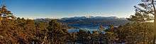
Samnanger lies at the inner end of the Samnangerfjorden. Bjørnafjorden Municipality lies to the south, Bergen Municipality is to the west, Vaksdal Municipality is to the north, and Kvam Municipality is to the east. Samnanger lies on the mainland of Norway, but its western parts lie on the Bergen Peninsula—a large peninsula connected to the mainland by a small isthmus of land running between Trengereid in Bergen and Trengereidfjorden in Samnanger.
The Gullfjellet mountains lie along the western border of the municipality. The mountain Sveningen lies at the tripoint border with Samnanger, Bergen, and Bjørnafjorden municipalities. The Kvamskogen mountain plateau lies along the eastern border of the municipality.
References
- "Navn på steder og personer: Innbyggjarnamn" (in Norwegian). Språkrådet.
- "Forskrift om målvedtak i kommunar og fylkeskommunar" (in Norwegian). Lovdata.no.
- Statistisk sentralbyrå (2020). "Table: 06913: Population 1 January and population changes during the calendar year (M)" (in Norwegian).
- Statistisk sentralbyrå (2020). "09280: Area of land and fresh water (km²) (M)" (in Norwegian).
- Fjelltveit, Ingvild; Raunholm, Per Vidar (2016-12-20). "Foreslår å legge ned 17 lensmannskontor i Vest politidistrikt". NRK Hordaland (in Norwegian). Retrieved 2017-10-20.
- Jukvam, Dag (1999). "Historisk oversikt over endringer i kommune- og fylkesinndelingen" (PDF) (in Norwegian). Statistisk sentralbyrå.
- Store norske leksikon. "Samnanger" (in Norwegian). Retrieved 2014-07-13.
- "Civic heraldry of Norway - Norske Kommunevåpen". Heraldry of the World. Retrieved 2020-02-02.
- Hansen, Tore, ed. (2016-05-12). "kommunestyre". Store norske leksikon (in Norwegian). Kunnskapsforlaget. Retrieved 2019-04-06.
- "Tall for Norge: Kommunestyrevalg 2019 - Vestland". Valg Direktoratet. Retrieved 2020-02-02.
- "Table: 04813: Members of the local councils, by party/electoral list at the Municipal Council election (M)" (in Norwegian). Statistics Norway.
- "Tall for Norge: Kommunestyrevalg 2011 - Hordaland". Valg Direktoratet. Retrieved 2020-02-02.
- "Kommunestyrevalget 1995" (PDF) (in Norwegian). Oslo-Kongsvinger: Statistisk sentralbyrå. 1996. Retrieved 2020-02-20.
- "Kommunestyrevalget 1991" (PDF) (in Norwegian). Oslo-Kongsvinger: Statistisk sentralbyrå. 1993. Retrieved 2020-02-20.
- "Kommunestyrevalget 1987" (PDF) (in Norwegian). Oslo-Kongsvinger: Statistisk sentralbyrå. 1988. Retrieved 2020-02-20.
- "Kommunestyrevalget 1983" (PDF) (in Norwegian). Oslo-Kongsvinger: Statistisk sentralbyrå. 1984. Retrieved 2020-02-20.
- "Kommunestyrevalget 1979" (PDF) (in Norwegian). Oslo: Statistisk sentralbyrå. 1979. Retrieved 2020-02-20.
- "Kommunevalgene 1975" (PDF) (in Norwegian). Oslo: Statistisk sentralbyrå. 1977. Retrieved 2020-05-10.
- "Kommunevalgene 1972" (PDF) (in Norwegian). Oslo: Statistisk sentralbyrå. 1973. Retrieved 2020-05-10.
- "Kommunevalgene 1967" (PDF) (in Norwegian). Oslo: Statistisk sentralbyrå. 1967. Retrieved 2020-05-10.
- "Kommunevalgene 1963" (PDF) (in Norwegian). Oslo: Statistisk sentralbyrå. 1964. Retrieved 2020-05-10.
- "Kommunevalgene og Ordførervalgene 1959" (PDF) (in Norwegian). Oslo: Statistisk sentralbyrå. 1960. Retrieved 2020-05-10.
- "Kommunevalgene og Ordførervalgene 1955" (PDF) (in Norwegian). Oslo: Statistisk sentralbyrå. 1957. Retrieved 2020-05-10.
- "Kommunevalgene og Ordførervalgene 1951" (PDF) (in Norwegian). Oslo: Statistisk sentralbyrå. 1952. Retrieved 2020-05-10.
- "Kommunevalgene og Ordførervalgene 1947" (PDF) (in Norwegian). Oslo: Statistisk sentralbyrå. 1948. Retrieved 2020-05-10.
- "Kommunevalgene og Ordførervalgene 1945" (PDF) (in Norwegian). Oslo: Statistisk sentralbyrå. 1947. Retrieved 2020-05-10.
- "Kommunevalgene og Ordførervalgene 1937" (PDF) (in Norwegian). Oslo: Statistisk sentralbyrå. 1938. Retrieved 2020-05-10.
External links
| Wikimedia Commons has media related to Samnanger. |
- Municipal fact sheet from Statistics Norway (in Norwegian)
 |
|  | |||