Sandane
Sandane is the administrative centre of the municipality of Gloppen in Vestland county, Norway. It is located at the end of the Gloppefjorden, along the European route E39 highway. Sandane is 20 kilometres (12 mi) south of the village of Nordfjordeid and about 16 kilometres (9.9 mi) west of the village of Byrkjelo. Sandane Airport, Anda is located 10 kilometres (6.2 mi) northwest of Sandane along highway E39. Sandane has several suburban areas that surround the nearby fjord such as Sørstranda to the west and Vereide to the northwest.
Sandane | |
|---|---|
Village | |
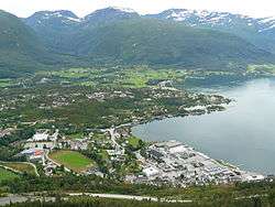 View of Sandane | |
 Sandane Location of the village  Sandane Sandane (Norway) | |
| Coordinates: 61.7769°N 6.2164°E | |
| Country | Norway |
| Region | Western Norway |
| County | Vestland |
| District | Nordfjord |
| Municipality | Gloppen |
| Area | |
| • Total | 2.38 km2 (0.92 sq mi) |
| Elevation | 10 m (30 ft) |
| Population (2019)[1] | |
| • Total | 2,447 |
| • Density | 1,028/km2 (2,660/sq mi) |
| Time zone | UTC+01:00 (CET) |
| • Summer (DST) | UTC+02:00 (CEST) |
| Post Code | 6823 Sandane |
The 2.38-square-kilometre (590-acre) village has a population (2019) of 2,447 and a population density of 1,028 inhabitants per square kilometre (2,660/sq mi).[1] The Firda Upper Secondary School and Sandane Church are both located in Sandane. Sandane is located close to the lake Breimsvatn, the Myklebustbreen glacier, and Jostedalsbreen National Park.
Culture
The Glopperock festival has been held in Sandane since 1980.
References
- Statistisk sentralbyrå (1 January 2019). "Urban settlements. Population and area, by municipality".
- "Sandane, Gloppen (Sogn og Fjordane)". yr.no. Retrieved 2019-11-06.
External links
