Fernandina Beach, Florida
Fernandina Beach is a city in Nassau County, Florida, United States, on Amelia Island. It is the northernmost city on Florida's Atlantic coast, and is one of the principal municipalities comprising Greater Jacksonville. The area was first inhabited by the Timucuan Indian tribe. Located on Amelia Island, known as the "Isle of 8 Flags", Fernandina has had the flags of the following nations flown over it since 1562: France, Spain, Great Britain, Spain (again), the Republic of Florida, the Green Cross of Florida, Mexico, the Confederate States of America, and the United States. It is the only municipality in the United States that has flown eight different national flags.[5]
Fernandina Beach | |
|---|---|
| City of Fernandina Beach | |
 Images from top, left to right: Beach, statue of a pirate (the mascot of Fernandina Beach High School), Nassau County Courthouse (Florida), shrimp statue (representing the annual Shrimp Festival), United States Post Office, Custom House, and Courthouse (Fernandina, Florida, 1912), Fort Clinch, Old School House, Fort Clinch Pier | |
 Seal | |
| Nickname(s): Isle of 8 Flags | |
 Location in Nassau County and the state of Florida | |
 Fernandina Beach Location in the U.S. | |
| Coordinates: 30°40′10″N 81°27′42″W | |
| Country | United States |
| State | Florida |
| County | Nassau |
| Government | |
| • Mayor | Johnny Miller |
| • Vice-Mayor | Len Kreger |
| • Commissioner | Mike Lednovich |
| • Commissioner | Dr. Ronald "Chip" Ross |
| • Commissioner | Phil Chapman |
| Area | |
| • Total | 12.14 sq mi (31.46 km2) |
| • Land | 11.44 sq mi (29.63 km2) |
| • Water | 0.70 sq mi (1.83 km2) |
| Elevation | 25 ft (7.6 m) |
| Population (2010) | |
| • Total | 11,487 |
| • Estimate (2019)[2] | 13,169 |
| • Density | 1,097.73/sq mi (423.83/km2) |
| Time zone | UTC-5 (EST) |
| • Summer (DST) | UTC-4 (EDT) |
| ZIP codes | 32034-32035 |
| Area code(s) | 904 |
| FIPS code | 12-22175[3] |
| GNIS feature ID | 0294308[4] |
| Website | www.fbfl.us. |
According to the 2010 census, the city population was 11,487. It is the seat of Nassau County.[6]
History
Prior to the arrival of Europeans on what is now Amelia Island, Native Americans occupied the site of the original town of Fernandina.[7] Native American bands associated with the Timucuan mound-building culture had settled on the island about A.D. 1000, calling it Napoyca. They remained on the island until the early 18th century, when European settlement began.
French and Spanish Settlement
French Huguenot explorer Jean Ribault became the first recorded European visitor to Napoyca in 1562, which he named Isle de Mai. In 1565, Spanish forces led by Pedro Menéndez de Avilés drove the French from northeastern Florida, killing Ribault and approximately 350 other French colonists. In 1573, Spanish Franciscans established the Santa Maria mission on the island, which they called Isla de Santa Maria. The mission was abandoned in 1680 after the inhabitants refused a Spanish order to relocate. British raids forced the relocation of the Santa Catalina de Guale mission on Georgia's St. Catherines Island, to the abandoned Santa Maria mission on the island in 1685. In 1702, this mission was again abandoned when South Carolina's colonial governor, James Moore, led a joint British-Indian invasion of Florida.
Georgia's founder and colonial governor, James Oglethorpe, renamed the island "Amelia Island" in honor of Princess Amelia (1711–1786), King George II's daughter, although the island was still a Spanish possession. In 1736, James Oglethorpe, the governor of Georgia, ordered Fort Amelia to be built at the mouth of the St. Marys River to house a garrison of Scottish Highlanders.[8][9] After establishing a small settlement on the northwestern edge of the island, Oglethorpe negotiated with Spanish colonial officials for a transfer of the island to British sovereignty. Colonial officials agreed to the transfer, but the King of Spain rescinded the agreement.
British Possession
The Treaty of Paris in 1763 ratified Britain's victory over France in the Seven Years' War. Spain ceded Florida to Britain in exchange for Havana, nullifying all Spanish land grants in Florida. The Proclamation of 1763 established the St. Marys River as East Florida's northeastern boundary.
Although not officially allied with the Americans during the Revolutionary War,[10] Spain cooperated with them as co-belligerents against the British in some actions.[11] In 1783, the Second Treaty of Paris ended hostilities, and under its terms Great Britain ceded East and West Florida to Spain, and all British inhabitants of the Floridas, including those on Amelia Island, had to leave within 18 months unless they swore allegiance to Spain and professed Catholicism.[12][13]
Old Town Fernandina
On January 1, 1811, Enrique White, governor of Spain's East Florida province, named the town of Fernandina, about a mile from the present city, in honor of King Ferdinand VII. On May 10 of that year,[14] Fernandina became the last town platted under the Laws of the Indies in the Western hemisphere. The town was intended as a bulwark against U.S. territorial expansion. In the following years, it was captured and recaptured by a succession of renegades and privateers.
Republic of East Florida
At the beginning of the Patriot War, with the approval of President James Madison and Georgia Governor George Mathews on March 13, 1812,[15] insurgents known as the "Patriots of Amelia Island" seized the island. After raising a Patriot flag, they replaced it with the United States flag. American gunboats under the command of Commodore Hugh Campbell maintained control of the island. On May 15, 1812, the British brig. Sappho fired on Gunboat no. 168, which had fired on the loyalist merchant vessel Fernando to prevent her leaving. Outgunned, the American gunboat withdrew, which enabled several vessels to escape from the port. President Madison eventually denounced the filibustering of George Mathews, however, on the grounds that Mathews had violated his instructions.[16]
Mexico
Spanish pressure forced the American evacuation from the island in 1813. Spanish forces erected Fort San Carlos on the island in 1816. However, A Scottish soldier and adventurer named Gregor MacGregor with 55 musketeers seized Fort San Carlos in 1817, claiming the island on behalf of "the brethren of Mexico, Buenos Ayres, New Grenada and Venezuela".[17] MacGregor claimed to be Brigadier General of the armies of the United Provinces of New Grenada and Venezuela (where he had successfully fought and led troops), and General-in-Chief of the armies for the two Floridas, commissioned by the Supreme Director of Mexico.[17]
Spanish soldiers forced MacGregor's withdrawal, but their attempt to regain complete control was foiled by American irregulars organized by Ruggles Hubbard and former Pennsylvania congressman Jared Irwin. Hubbard and Irwin later joined forces with the French-born pirate Louis Aury, who laid claim to the island on behalf of the Republic of Mexico. U.S. Navy forces drove Aury from the island, and President James Monroe vowed to hold Amelia Island "in trust for Spain."
Modern Fernandina
In 1847 construction of Fort Clinch began in nearby present-day Fernandina. The Third System fort was named after General Duncan Lamont Clinch who fought in the War of 1812 and the Seminole Wars. Senator David Levy Yulee, founder of the Florida Railroad, wanted the eastern terminus of his railroad line to end in Amelia Island. The Old Town Fernandina was too cut off by the marshes to be used as a terminal. Yulee wanted to end the railroad on the banks of the Amelia River one mile to the south. The leaders of Fernandina did not want a new community to grow and prosper to surpass their town. The leaders of Fernandina decided to move the town up to the railroad where the present-day Fernandina Beach stands. Yulee began construction of the railroad in 1855 and was completed in 1861.[18]
Civil War

On January 8, 1861, two days before Florida's secession, Confederate sympathizers (the Third Regiment of Florida Volunteers) took control of Fort Clinch, already abandoned by the Federal workers who had been enlarging the structure. The Confederates erected batteries on the northern end of Amelia Island but lacked the resources to fortify Fort Clinch. Robert E. Lee, who was commanding coastal defenses in the Deep South, ordered cannons and troops withdrawn in early 1862.
Lee's orders to withdraw the cannons and troops were too late. Union forces, consisting of 28 gunboats commanded by Commodore Samuel Dupont, occupied the island on March 3, 1862, and raised the American flag. In January 1863, the first all-black regiment of former slaves recruited to fight for the Union was read Lincoln's Emancipation Proclamation at Fernandina. Three weeks later they set sail up the St. Marys River to engage the Confederate forces. The Union used the fort as a base for its operations in the area for the remainder of the war.[18]
Later 19th century
In 1891, Harmon Murray, who had been the leader of a criminal gang operating out of Gainesville, arrived in Fernandina, where his sister lived. Murray was soon committing burglaries and robberies in Fernandina and elsewhere on Amelia Island. Law officers chased a black suspect several times, who shot at them on one occasion. Murray taunted the police with a letter in early May, to the effect that he would not be taken alive, and would take the Nassau County sheriff and Fernandina police chief with him. Acting on a tip, on May 16 police surrounded the house Murray was staying in. Murray heard the officers getting into position, and shot and killed deputy sheriff Joseph W. Robinson. In the ensuing gun battle Murray wounded Fernandina Police Chief James Higgenbotham. Although grazed on the wrist and scalp, Murray was able to escape. Despite the intensive manhunt for him, Murray was able to slip off of Amelia Island to the mainland. The City of Fernandina offered a reward for the capture of Murray, "dead or alive".[19][20] [21]
Geography
Fernandina Beach is located at 30°24′04″N 81°16′27″W,[22] approximately 25 miles (40 km) northeast of downtown Jacksonville.
According to the United States Census Bureau, the city has a total area of 15.7 square miles (41 km2), all land. It is the northernmost city on the eastern coast of Florida.
Climate
| Climate data for Fernandina Beach, Florida (elevation 49 ft.) | |||||||||||||
|---|---|---|---|---|---|---|---|---|---|---|---|---|---|
| Month | Jan | Feb | Mar | Apr | May | Jun | Jul | Aug | Sep | Oct | Nov | Dec | Year |
| Average high °F (°C) | 63.0 (17.2) |
65.8 (18.8) |
71.2 (21.8) |
76.8 (24.9) |
83.3 (28.5) |
88.0 (31.1) |
90.6 (32.6) |
89.3 (31.8) |
85.6 (29.8) |
79.2 (26.2) |
72.2 (22.3) |
64.9 (18.3) |
77.5 (25.3) |
| Daily mean °F (°C) | 53.8 (12.1) |
56.5 (13.6) |
61.9 (16.6) |
67.7 (19.8) |
75.0 (23.9) |
80.4 (26.9) |
82.6 (28.1) |
82.1 (27.8) |
79.2 (26.2) |
72.1 (22.3) |
63.9 (17.7) |
56.3 (13.5) |
69.3 (20.7) |
| Average low °F (°C) | 44.5 (6.9) |
47.2 (8.4) |
52.6 (11.4) |
58.6 (14.8) |
66.7 (19.3) |
72.8 (22.7) |
74.6 (23.7) |
74.9 (23.8) |
72.8 (22.7) |
65.0 (18.3) |
55.6 (13.1) |
47.6 (8.7) |
61.1 (16.2) |
| Average precipitation inches (mm) | 3.42 (87) |
3.20 (81) |
3.92 (100) |
2.82 (72) |
2.31 (59) |
5.27 (134) |
5.52 (140) |
5.82 (148) |
6.91 (176) |
4.59 (117) |
2.08 (53) |
2.95 (75) |
48.81 (1,240) |
| Average precipitation days (≥ 0.01 in) | 9.1 | 8.4 | 8.4 | 5.9 | 6.0 | 11.5 | 11.9 | 12.5 | 11.8 | 8.1 | 7.3 | 8.2 | 109.1 |
| Source: NOAA (1981-2010 Normals)[23][24] | |||||||||||||
Demographics
| Historical population | |||
|---|---|---|---|
| Census | Pop. | %± | |
| 1860 | 1,390 | — | |
| 1870 | 1,722 | 23.9% | |
| 1880 | 2,562 | 48.8% | |
| 1890 | 2,803 | 9.4% | |
| 1900 | 3,245 | 15.8% | |
| 1910 | 3,482 | 7.3% | |
| 1920 | 3,147 | −9.6% | |
| 1930 | 3,023 | −3.9% | |
| 1940 | 3,492 | 15.5% | |
| 1950 | 4,420 | 26.6% | |
| 1960 | 7,276 | 64.6% | |
| 1970 | 6,955 | −4.4% | |
| 1980 | 7,224 | 3.9% | |
| 1990 | 8,765 | 21.3% | |
| 2000 | 10,549 | 20.4% | |
| 2010 | 11,487 | 8.9% | |
| Est. 2019 | 13,169 | [2] | 14.6% |
| U.S. Decennial Census[25] | |||
As of the census of 2010, there were 11,487 people, 5,176 households, and 3,207 families residing in the city. The population density was 1,031.8 people per square mile (397.9/km2). There were 7,064 housing units at an average density of 449.9 per square mile (173.7/km2). The racial makeup of the city was 83.4% White, 11.7% African American, 0.4% Native American, 1.1% Asian, 0.1% Pacific Islander, 0.1% from other races and 1.3% from two or more races. Hispanics or Latinos of any race were 5.3% of the population.
Out of 4,789 households 21.5% had children under the age of 18 living with them, 45.3% were married couples living together, 12.3% had a female householder with no husband present, and 38.0% were non-families. 30.6% of all households were made up of householders living alone, and 12.5% had someone living alone who was 65 years of age or older. The average household size was 2.18 and the average family size was 2.65.
In the city, the population was spread out, with 16.3% under the age of 18, 6.7% from 20 to 24, 20.1% from 25 to 44, 34.6% from 45 to 64, and 22.3% who were 65 years of age or older. The median age was 50.[26]
The median income for a household in the city was $45,954, and the median income for a family was $61,523. Males had a median income of $42,188 versus $35,934 for females. The per capita income for the city was $30,019. About 16% of families and 17.2% of the population were below the poverty line, including 33.0% of those under age 18 and 13.6% of those age 65 or over.[27]
Ethnicity
As of 2016 the largest self-reported ancestries/ethnicities in Fernandina Beach, Florida were:[28]
| Largest ancestries (2016) | Percent |
|---|---|
| English | 14.7% |
| "American" | 14.5% |
| German | 12.6% |
| Irish | 10.2% |
| Italian | 5.2% |
| French | 3.3% |
| Polish | 3.0% |
| Scottish | 2.1% |
| Scots-Irish | 2.1% |
| Dutch | 1.4% |
| Welsh | 1.3% |
| Norwegian | 1.2% |
| Russian | 0.6% |
Government and infrastructure
Nassau County Fire Rescue operates Station 20 on the south end of Amelia Island,[29] as well as Station 70 Oneil.[30]
The Fernandina Beach Municipal Airport is a general aviation airfield approximately three miles south of the city that serves Amelia Island.
The Mayor of Fernandina Beach is Johnny Miller.
Education
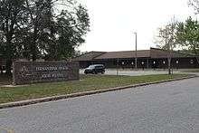
The public schools of Fernandina Beach are part of the Nassau County School District. They include:
- Southside Elementary School (PreK-2)
- Emma Love Hardee Elementary School (3-5)
- Fernandina Beach Middle School (6-8)
- Fernandina Beach High School (9-12)
 Fernandina Beach Christian Academy
Private schools:
- Amelia Island Montessori School (Preschool-8)
- Fernandina Beach Christian Academy (K-8)
- St Michael Academy (PreK-8)
Note: Atlantic Elementary (2nd and 3rd grades) was closed at the end of the 2008 school year. After the closing, 2nd grade was moved to Southside and 3rd grade to Emma Love. Also, the private Catholic school, St. Michael's Academy, is in downtown Fernandina Beach. All three Fernandina Beach public schools are "A" rated by the State of Florida. The nickname of Fernandina Beach High School's athletic teams is the "Pirates".[31] Amelia Island Montessori School is near American Beach and is accredited by the Florida Council of Independent Schools and is an associate member school with the American Montessori Society.
Nassau County Public Library operates the Fernandina Beach Branch.[32]
Notable people
- William B. Allen, political scientist who was chairman of the United States Commission on Civil Rights from 1988 to 1989, was born in Fernandina Beach in 1944.
- Raymond A. Brown, attorney whose clients included Black Liberation Army member Assata Shakur, boxer Rubin "Hurricane" Carter and "Dr. X" physician Mario Jascalevich.[33]
- George Rainsford Fairbanks, a Confederate Major in the U.S. Civil War, he was also a historian, lawyer and Florida State Senator. The Fairbanks House is listed on the NRHP and is operated as a bed and breakfast lodging establishment.
- Joseph Finegan, businessman, Brigadier general for the Confederate States Army; resident of Fernandina Beach.
- Rick Stockstill, football head coach at Middle Tennessee; raised in Fernandina Beach.
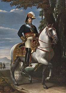
- David Levy Yulee, Florida Territorial representative to Congress and the first U.S. Senator from Florida when it became a state, member of the Confederate Congress, builder of Florida's first cross-state railroad (Fernandina to Cedar Key). There is a statue of Yulee in the town.[34]
Attractions
The 1988 fantasy film The New Adventures of Pippi Longstocking was filmed in Fernandina Beach and at soundstages in Jacksonville.[35] The house that stood in for Villa Villekulla, Pippi's home, is known locally as Captain Bell's House and is on Estrada Street in the Old Town area directly across from the Fernandina Plaza (parade ground for the Spanish fort) and overlooking the Amelia River.[36]
The Isle of Eight Flags Shrimp Festival occurs annually over the first weekend in May. Events and activities of the festival include vendors with seafood, arts, crafts, collectibles and antiques, live music, the Miss Shrimp Festival pageant, a fireworks display and a parade.[37]
Historic places
- Original Town of Fernandina Historic Site
- Fairbanks House
- Historic Nassau County Courthouse
- United States Post Office, Custom House, and Courthouse (Fernandina, Florida, 1912)
- Fort Clinch State Park
- See National Register of Historic Places listings in Nassau County, Florida
References
- "2018 U.S. Gazetteer Files". United States Census Bureau. Retrieved July 19, 2019.
- "Population and Housing Unit Estimates". Retrieved May 21, 2020.
- "U.S. Census website". United States Census Bureau. Retrieved January 31, 2008.
- "US Board on Geographic Names". United States Geological Survey. October 25, 2007. Retrieved January 31, 2008.
- "The Isle of 8 Flags". www.fbfl.us.
- "Find a County". National Association of Counties. Archived from the original on May 31, 2011. Retrieved June 7, 2011.
- "Fernandina Plaza Historic State Park" (PDF). State of Florida Department of Environmental Protection Division of Recreation and Parks. March 10, 2004. p. 11. Retrieved April 30, 2013.
- Spencer Tucker (November 21, 2012). Almanac of American Military History. ABC-CLIO. p. 128. ISBN 978-1-59884-530-3.
- Anthony W. Parker (July 1, 2010). Scottish Highlanders in Colonial Georgia: The Recruitment, Emigration, and Settlement at Darien, 1735-1748. University of Georgia Press. p. 75. ISBN 978-0-8203-2718-1.
- Judith Ann Bense (1999). Archaeology of Colonial Pensacola. University Press of Florida. p. 34. ISBN 978-0-8130-1661-0.
- Albert W. Haarmann (October 1960). "The Spanish Conquest of British West Florida, 1779-1781". The Florida Historical Quarterly. 2. 39. Florida Historical Society. p. 108.
- William C. Davis (April 20, 2011). The Rogue Republic: How Would-Be Patriots Waged the Shortest Revolution in American History. Houghton Mifflin Harcourt. p. 6. ISBN 978-0-547-54915-6.
- University of Southwestern Louisiana. Center for Louisiana Studies (August 1996). The Spanish presence in Louisiana, 1763-1803. Center for Louisiana Studies, University of Southwestern Louisiana. p. 318. ISBN 9781887366038.
- Louise Biles Hill (1941). "George J. F. Clarke, 1774-1836". Florida Historical Quarterly. 21 (3 ed.). Florida Historical Society. p. 214. Retrieved May 3, 2013.
- Cusick, James G. (2007). The other war of 1812 : the Patriot War and the American invasion of Spanish East Florida. Athens, Georgia: University of Georgia Press. p. 32. ISBN 978-0820329215.
- "Archived copy". Archived from the original on February 9, 2009. Retrieved July 23, 2008.CS1 maint: archived copy as title (link) Manifest Destiny's Underworld: Filibustering in Antebellum America. Robert E. May. Chapter 1
- "Another View of Gregor MacGregor" Archived March 28, 2009, at the Wayback Machine in Amelia Now On Line, Winter 2001.
- "Seaport built for a Railroad". exploresouthernhistory.com. Retrieved May 6, 2018.
- Braley, R. Olin (2004). The Killing of Harmon Murray. Gainesville, Florida: The Alachua Press. pp. 69–71.
- Chandler, Billy Jaynes (October 1994). "Harmon Murray: Black Desperado in Late Nineteenth-Century Florida". The Florida Historical Quarterly. 73 (2): 190. JSTOR 30148759.
- "Memorials/Fallen Deputies - Deputy Joseph W. Robinson". Nassau County Sheriff's Office. Retrieved November 7, 2018.
- "US Gazetteer files: 2010, 2000, and 1990". United States Census Bureau. February 12, 2011. Retrieved April 23, 2011.
- "NOWData - NOAA Online Weather Data". National Oceanic and Atmospheric Administration. Retrieved February 8, 2016.
- "Station Name: FL FERNANDINA BEACH". National Oceanic and Atmospheric Administration. Retrieved February 8, 2016.
- "Census of Population and Housing". Census.gov. Retrieved June 4, 2015.
- U.S. Census Bureau. "Fernandina Beach (city), Florida". State & County QuickFacts. U.S. Government. Archived from the original on May 8, 2012. Retrieved August 18, 2012.
- U.S. Census Bureau. "2010 Demographic Profile Data". Profile of General Population and Housing Characteristics: 2010. U.S. Government. Retrieved August 18, 2012.
- "Archived copy". Archived from the original on February 13, 2020. Retrieved July 9, 2018.CS1 maint: archived copy as title (link)
- "Station 20." Nassau County. Retrieved on February 14, 2017. "Station 20 South end of Amelia Island 5518 First Coast Highway Fernandina Beach, Florida 32034"
- "Station 70." Nassau County. Retrieved on February 14, 2017. "Station 70 Oneil 96031 Pine Grove Road Fernandina Beach, Florida 32034"
- "Fernandina Beach High School / Homepage". www.nassau.k12.fl.us. Retrieved December 29, 2017.
- "Fernandina Beach Branch Library." Nassau County Public Library. Retrieved on February 10, 2017. "Location Fernandina Library Branch 25 N. 4th St. Fernandina Beach, FL 32034"
- Berger, Joseph. "Raymond A. Brown, Civil Rights Lawyer, Dies at 94", The New York Times, October 11, 2009. Accessed October 12, 2009.
- Feldman, Ari (August 20, 2017). "Why Are There No Statues Of Jewish Confederate Judah Benjamin To Tear Down?". Forward. Retrieved September 6, 2017.
There is only one known statue of a Jewish Confederate leader. It depicts David Levy Yulee, an industrialist, plantation owner and Confederate senator from Florida, and it shows him sitting on a bench.
- James P. Goss (2000). Pop Culture Florida. Pineapple Press Inc. p. 103. ISBN 978-1-56164-199-4.
- "Archived copy". Archived from the original on November 23, 2015. Retrieved December 29, 2015.CS1 maint: archived copy as title (link)
- "Shrimp festival kicks off in Fernandina Beach". News4Jax. May 3, 2012. Archived from the original on May 9, 2012. Retrieved April 18, 2013.
External links
| Wikimedia Commons has media related to Fernandina Beach, Florida. |
- City of Fernandina Beach
- Fernandina Beach News-Leader, full text with full page images, freely available in the Florida Digital Newspaper Library
- Fernandina Express, 1880s historic newspaper freely available with full text and full page images in the Florida Digital Newspaper Library
- http://www.floridastateparks.org/fortclinch/default.cfm, the State's official web site for Fort Clinch
Municipalities and communities of Nassau County, Florida, United States | ||
|---|---|---|
| City | 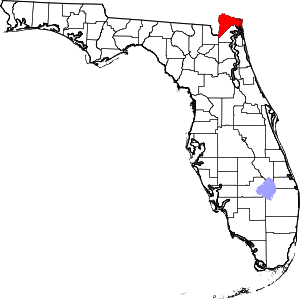 | |
| Towns | ||
| CDPs | ||
| Unincorporated communities |
| |
| Counties |  | |
|---|---|---|
| Cities, towns and CDPs | ||
Region of Florida | ||
| Topics |  Map of North Florida | |
| Counties | ||
| Major cities | ||
| Cities and towns 100k+ | ||
| Cities and towns 25k–100k | ||
| Cities and towns 10k–25k | ||
| Metro areas |
| |
| Regions | ||
| Authority control |
|
|---|