East End of London
The East End of London, often referred to within the London area simply as the East End, is the historic core of wider East London, east of the Roman and medieval walls of the City of London and north of the River Thames. It does not have universally accepted boundaries to the north and east, though the River Lea is sometimes seen as the eastern boundary. Parts of it may be regarded as lying within Central London (though that term too has no precise definition). The term "East of Aldgate Pump" is sometimes used as a synonym for the area.
The East End began to emerge in the Middle Ages with initially slow urban growth outside the eastern walls, which later accelerated, especially in the 19th century, to absorb pre-existing settlements. The first known written record of the East End as a distinct entity, as opposed its component parts, comes from John Strype's 1720 Survey of London, which describes London as consisting of four parts: the City of London, Westminster, Southwark, and "That Part beyond the Tower". The relevance of Strype's reference to the Tower was more than geographical. The East End was the urbanised part of an administrative area called the Tower Division, which had owed military service to the Tower of London since time immemorial. Later, as London grew further, the fully urbanised Tower Division became a byword for wider East London, before East London grew further still, east of the River Lea and into Essex.
The area was notorious for its deep poverty, overcrowding and associated social problems. This led to the East End's history of intense political activism and association with some of the country's most influential social reformers. Another major theme of East End history has been migration, both inward and outward. The area had a strong pull on the rural poor from other parts of England, and attracted waves of migration from further afield, notably Huguenot refugees, who created a new extramural suburb in Spitalfields in the 17th century,[1] Irish weavers,[2] Ashkenazi Jews,[3] and, in the 20th century, Sylheti Bangladeshis.[4]
The closure of the last of the East End docks in the Port of London in 1980 created further challenges and led to attempts at regeneration and the formation of the London Docklands Development Corporation. The Canary Wharf development improved infrastructure, and the Olympic Park[5] mean that the East End is undergoing further change, but some parts continue to contain some of the worst poverty in Britain.[6]
Uncertain boundaries
The East End lies east of the Roman and medieval walls of the City of London and north of the River Thames. Aldgate Pump, on the edge of the City, is regarded as the symbolic start of the East End. On the river, Tower Bridge is also sometimes described in these terms.
Beyond these reference points, the East End has no official or generally accepted boundaries; views vary as to how much of wider East London lies within it.
In extending from the line of the former walls, the area is taken to include the small ancient extramural City wards of Portsoken[7] and Bishopsgate Without[8] (as established until 21st century boundary reviews). The various channels of the River Lea are sometimes viewed as the eastern boundary.[9]
Beyond the small eastern extramural wards, the narrowest definition restricts the East End to the modern London Borough of Tower Hamlets.[10][11] A more common preference is to add to Tower Hamlets the former parish and borough of Shoreditch (including Hoxton and Haggerston), which is now the southern part of the modern London Borough of Hackney.[12][13] Other commentators prefer a definition broader still, encompassing districts such as West Ham,[13][14] East Ham,[13][14] Leyton,[14] Walthamstow,[14] parts or all of Hackney[15] (the district, rather than the larger modern borough) and Ilford.
The wider East London area might be said to comprise, or approximate to, the two eastern wards of the City, the former Tower Division and those parts of London east of the Lea.
Development and economy
Emergence
The East End began with the medieval growth of London beyond its walls, along the Roman roads leading from Bishopsgate and Aldgate and also alongside the Thames.
Growth was much slower in the east, and the modest extensions on this side were separated from the much larger extensions in the west by the marshy open area of Moorfields adjacent to the wall on the north side, which discouraged development in that direction.
Building accelerated in the 16th century, and the area that would later become known as the East End began to take shape.
In 1720 John Strype gives us our first record of the East End as a distinct entity when he describes London as consisting of four parts: the City of London, Westminster, Southwark, and "That Part beyond the Tower".
The relevance of Strype's reference to the Tower was more than geographical. The East End was the urbanised part of an administrative area called the Tower Division, which had owed military service to the Tower of London since time immemorial, having its roots in the Bishop of London's historic Manor of Stepney. Later, as London grew further, the fully urbanised Tower Division became a byword for wider East London, before East London grew further still, east of the River Lea and into Essex.
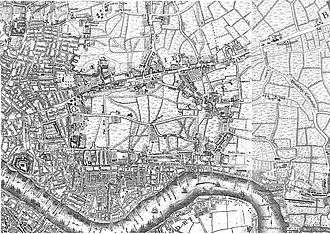
For a very long time the East End was physically separated from London's western growth by the open space known as Moorfields. Shoreditch's boundary with the parish of St Luke's (and its predecessor St Giles-without-Cripplegate) ran through the Moorfields, which became, on urbanisation, the boundary of east and north London. That line, with very slight modifications, also became part of the boundary between the modern London Boroughs of Hackney and Islington.
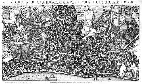
Moorfields remained largely open until 1812, and the longstanding presence of that open space separating the emerging East End from the western urban expansion of London must have helped shape the different economic character of the two parts and perceptions of their distinct identity (see map below).
The East End has always contained some of London's poorest areas. The main reasons for this include:
- The medieval system of copyhold, which prevailed throughout the East End into the 19th century. Essentially, there was little point in developing land that was held on short leases.[13]
- The siting of noxious industries, such as tanning and fulling downwind outside the boundaries of the City, and therefore beyond complaints and official controls. The foul-smelling industries partially preferred the East End because the prevailing winds in London traveled from west to east (i.e. it was downwind from the rest of the city), so that most odours from their businesses would not go into the city.
- The low paid employment in the docks and related industries, made worse by the trade practices of outwork, piecework and casual labour.
- The concentration of the ruling court and national political centre in Westminster, on the opposite, western side of the City of London.
Historically, the East End is arguably conterminous with the Manor of Stepney. This manor was held by the Bishop of London, in compensation for his duties in maintaining and garrisoning the Tower of London. Edward VI passed the land to the Wentworth family, and thence to their descendants, the Earls of Cleveland. The system of copyhold, whereby land was leased to tenants for terms as short as seven years, prevailed throughout the manor. This severely limited scope for improvement of the land and new building until the estate was broken up in the 19th century.[16]
In medieval times trades were carried out in workshops in and around the owners' premises in the City. By the time of the Great Fire of London in 1666 these were becoming industries, and some were particularly noisome, such as the processing of urine for the tanning industry, or required large amounts of space, such as drying clothes after process and dying in fields known as tentergrounds. Some were dangerous, such as the manufacture of gunpowder or the proving of guns. These activities came to be performed outside the City walls in the near suburbs of the East End. Later, when lead-making and bone-processing for soap and china came to be established, they too located in the East End rather than in the crowded streets of the City.[13]
The lands east of the City had always been used as hunting grounds for bishops and royalty, with King John establishing a palace at Bow. The Cistercian Stratford Langthorne Abbey became the court of Henry III in 1267 for the visitation of the Papal legates, and it was here that he made peace with the barons under the terms of the Dictum of Kenilworth. It became the fifth largest Abbey in the country, visited by monarchs and providing a retreat (and a final resting place) for the nobility.[17] The Palace of Placentia at Greenwich, to the south of the river, was built by the Regent to Henry V, Humphrey, Duke of Gloucester and Henry VIII established a hunting lodge at Bromley Hall.[18] These Royal connections continued until after the Interregnum (1649–60) when the Court established itself in the Palace of Whitehall and the offices of politics congregated around them. The East End also lay on the main road to Barking Abbey, important as a religious centre since Norman times and where William the Conqueror had first established his English court.[19]
Accelerated 19th-century development
During the Middle Ages, settlements were established predominantly along the lines of the existing roads. The principal villages were Stepney, Whitechapel and Bow. Settlements along the river began at that time to service the needs of shipping on the Thames, but the City of London retained its right to land the goods. The riverside became more active in Tudor times (16th century), as the Royal Navy expanded and international trading developed, and a major fishing port developed downstream at Barking to provide fish for the City. These and other factors meant that industries relating to construction, repair, and victualling of naval and merchant ships flourished in the area.
Royalty such as King John had had a hunting lodge at Bromley-by-Bow, and the Bishop of London had a palace at Bethnal Green, but later these estates began to be split up, and estates of fine houses for captains, merchants and owners of manufacturers began to be built. Samuel Pepys moved his family and goods to Bethnal Green during the Great Fire of London, and Captain Cook moved from Shadwell to Stepney Green, where a school and assembly rooms had been established (commemorated by Assembly Passage, and a plaque on the site of Cook's house on the Mile End Road). Mile End Old Town also acquired some fine buildings, and the New Town began to be built. As the area became built up and more crowded, the wealthy sold their plots for subdivision and moved further afield. Into the 18th and 19th centuries, there were still attempts to build fine houses, for example Tredegar Square (1830), and the open fields around Mile End New Town were used for the construction of estates of workers' cottages in 1820. This was designed in 1817 in Birmingham by Anthony Hughes and finally constructed in 1820.[20]
Globe Town was established from 1800 to provide for the expanding population of weavers around Bethnal Green, attracted by improving prospects in silk weaving. Bethnal Green's population trebled between 1801 and 1831, with 20,000 looms being operated in people's own homes. By 1824, with restrictions on importation of French silks relaxed, up to half these looms had become idle, and prices were driven down. With many importing warehouses already established in the district, the abundance of cheap labour was turned to boot, furniture and clothing manufacture.[21] Globe Town continued its expansion into the 1860s, long after the silk industry's decline.
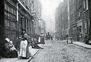
During the 19th century, building on an ad hoc basis could not keep up with the expanding population's needs. Henry Mayhew visited Bethnal Green in 1850 and wrote for the Morning Chronicle, as a part of a series forming the basis for London Labour and the London Poor (1851), that the trades in the area included tailors, costermongers, shoemakers, dustmen, sawyers, carpenters, cabinet makers and silkweavers. He noted that in the area:
roads were unmade, often mere alleys, houses small and without foundations, subdivided and often around unpaved courts. An almost total lack of drainage and sewerage was made worse by the ponds formed by the excavation of brickearth. Pigs and cows in back yards, noxious trades like boiling tripe, melting tallow, or preparing cat's meat, and slaughter houses, dustheaps, and 'lakes of putrefying night soil' added to the filth
— Henry Mayhew London Labour and London Poor (1851), [22]
A movement began to clear the slums. Burdett-Coutts built Columbia Market in 1869 and the "Artisans' and Labourers' Dwelling Act" passed in 1876 to provide powers to seize slums from landlords and to provide access to public funds to build new housing.[23] Philanthropic housing associations such as the Peabody Trust were formed to provide homes for the poor and to clear the slums generally. Expansion by the railway companies, such as the London and Blackwall Railway and Great Eastern Railway, caused large areas of slum housing to be demolished. The "Working Classes Dwellings Act" in 1890 placed a new responsibility to house the displaced residents and led to the building of new philanthropic housing such as Blackwall Buildings and Great Eastern Buildings.[24]
By 1890, official slum clearance programmes had begun. These included the creation of the world's first council housing, the LCC Boundary Estate, which replaced the neglected and crowded streets of Friars Mount, better known as The Old Nichol Street Rookery.[25] Between 1918 and 1939 the LCC continued replacing East End housing with five- or six-storey flats, despite residents preferring houses with gardens and opposition from shopkeepers who were forced to relocate to new, more expensive premises. The Second World War brought an end to further slum clearance.[26]
Industry and innovation
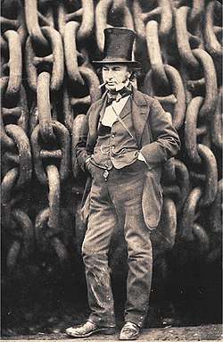
Industries associated with the sea developed throughout the East End, including rope making and shipbuilding. The former location of roperies can still be identified from their long straight, narrow profile in the modern streets, for instance Ropery Street near Mile End. Shipbuilding was important from the time when Henry VIII caused ships to be built at Rotherhithe as a part of his expansion of the Royal Navy. On 31 January 1858, the largest ship of that time, the SS Great Eastern, designed by Isambard Kingdom Brunel, was launched from the yard of Messrs Scott Russell & Co, of Millwall. The 692-foot (211 m) vessel was too long to fit across the river, and so the ship had to be launched sideways. Due to the technical difficulties of the launch, after this, shipbuilding on the Thames went into a long decline.[27] Ships continued to be built at the Thames Ironworks and Shipbuilding Company at Blackwall and Canning Town until the yard closed in 1913, shortly after the launch of the Dreadnought Battleship HMS Thunderer (1911).

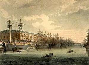
The West India Docks were established in 1803, providing berths for larger ships and a model for future London dock building. Imported produce from the West Indies was unloaded directly into quayside warehouses. Ships were limited to 6000 tons.[28] The old Brunswick Dock, a shipyard at Blackwall became the basis for the East India Company's East India Docks established there in 1806.[29] The London Docks were built in 1805, and the waste soil and rubble from the construction was carried by barge to west London, to build up the marshy area of Pimlico. These docks imported tobacco, wine, wool and other goods into guarded warehouses within high walls (some of which still remain). They were able to berth over 300 sailing vessels simultaneously, but by 1971 they closed, no longer able to accommodate modern shipping.[30] The most central docks, St Katharine Docks, were built in 1828 to accommodate luxury goods, clearing the slums that lay in the area of the former Hospital of St Katharine. They were not successful commercially, as they were unable to accommodate the largest ships, and in 1864, management of the docks was amalgamated with that of the London Docks.[31] The Millwall Docks were created in 1868, predominantly for the import of grain and timber. These docks housed the first purpose built granary for the Baltic grain market, a local landmark that remained until it was demolished to improve access for the London City Airport.[32]
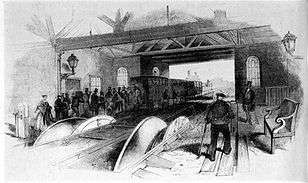
The first railway (the "Commercial Railway") to be built, in 1840, was a passenger service based on cable haulage by stationary steam engines that ran the 3.5 miles (5.6 km) from Minories to Blackwall on a pair of tracks. It required 14 miles (22.5 km) of hemp rope, and "dropped" carriages as it arrived at stations, which were reattached to the cable for the return journey, the train "reassembling" itself at the terminus.[33] The line was converted to standard gauge in 1859, and steam locomotives adopted. The building of London termini at Fenchurch Street (1841),[34] and Bishopsgate (1840) provided access to new suburbs across the River Lea, again resulting in the destruction of housing and increased overcrowding in the slums. After the opening of Liverpool Street station (1874), Bishopsgate railway station became a goods yard, in 1881, to bring imports from Eastern ports. With the introduction of containerisation, the station declined, suffered a fire in 1964 that destroyed the station buildings, and it was finally demolished in 2004 for the extension of the East London Line. In the 19th century, the area north of Bow Road became a major railway centre for the North London Railway, with marshalling yards and a maintenance depot serving both the City and the West India docks. Nearby Bow railway station opened in 1850 and was rebuilt in 1870 in a grand style, featuring a concert hall. The line and yards closed in 1944, after severe bomb damage, and never reopened, as goods became less significant, and cheaper facilities were concentrated in Essex.[35]
The River Lea was a smaller boundary than the Thames, but it was a significant one. The building of the Royal Docks consisting of the Royal Victoria Dock (1855), able to berth vessels of up to 8000 tons;[36] Royal Albert Dock (1880), up to 12,000 tons;[37] and King George V Dock (1921), up to 30,000 tons,[38] on the estuary marshes, extended the continuous development of London across the Lea into Essex for the first time.[39] The railways gave access to a passenger terminal at Gallions Reach and new suburbs created in West Ham, which quickly became a major manufacturing town, with 30,000 houses built between 1871 and 1901.[40] Soon afterwards, East Ham was built up to serve the new Gas Light and Coke Company and Bazalgette's grand sewage works at Beckton.[41]
Decline and regeneration
.jpg)
The East End has historically suffered from poor housing stock and infrastructure. From the 1950s, the area was a microcosm of the structural and social changes affecting the UK economy. The closure of docks, cutbacks in railways and loss of industry contributed to a long-term decline, removing many of the traditional sources of low- and semi-skilled jobs.
The docks declined from the mid-20th century, with the last, the Royal Docks, closing in 1980. Various wharves along the river continue to be used but on a much smaller scale. London's main port facilities are now at Tilbury and London Gateway (opened in 1886 and 2013 respectively), further downstream, beyond the Greater London boundary in Essex. These larger modern facilities can accommodate larger vessels and are suitable for the needs of modern container ships.[42]
There has been extensive regeneration, and the East End has become a desirable place for business,[6] partly due to the availability of brownfield land. Much of this development has been of little benefit to local communities and has caused a damaging rise in property prices, meaning that much of the area remains among the poorest in Britain.
Housing
The area had one of the highest concentrations of council housing, the legacy of slum clearance and wartime destruction.[43] Many of the 1960s tower blocks have been demolished or renovated, replaced by low-rise housing, often in private ownership, or owned by housing associations.[44]
Transport improvements
By the mid-1980s, the District line (extended to the East End in 1884 and 1902)[45] and Central line (1946)[46] were beyond capacity, and the Docklands Light Railway (1987) and Jubilee line (1999) were subsequently constructed to improve rail transport in the area.
There was a long-standing plan to provide London with an inner motorway box, the East Cross Route, but only a short section was built.[47] Road links were improved by the completion of the Limehouse Link tunnel under Limehouse Basin in 1993 and the extension of the A12 to connect to the Blackwall Tunnel in the 1990s. The extension of the East London line provided further improvements in 2010. From 2021, the Elizabeth Line will create an east-west service across London, with a major interchange at Whitechapel. New river crossings are planned at Beckton, (the Thames Gateway Bridge)[48] and at the proposed Silvertown Link road tunnel, intended to supplement the existing Blackwall Tunnel.[49]
City fringe regeneration
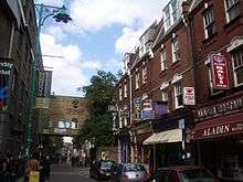
The continued strength of the City's financial services sector has seen many large office buildings erected around the City fringe, with indirect benefits accruing to local business. The area around Old Spitalfields Market has been redeveloped and Brick Lane, dubbed London's curry capital,[50] or Bangla Town,[51] has benefited from the City's success.
Art galleries have flourished, including the expanded Whitechapel Gallery and the workshop of artists Gilbert and George in Spitalfields.[52] The neighbourhood around Hoxton Square has become a centre for modern British art, including the White Cube gallery, with many artists from the Young British Artists movement living and working in the area. This has made the area around Hoxton and Shoreditch fashionable, a busy nightlife has developed,[53] but many former residents now driven out by higher property prices.
East London Tech City, a cluster of technology companies has developed in and around Shoreditch, and the Queen Mary University of London has expanded its existing site at Mile End, and opened specialist medical campuses at the Royal London Hospital and Whitechapel.
Regeneration at Canary Wharf and docklands
The devastating closure of the docks and the loss of the associated industries led to the establishment of the London Docklands Development Corporation[54] in 1981; the body was charged with using deregulation and other levers to stimulate economic regeneration.
As a consequence of this, and of investment in the area's transport infrastructure, there have been many urban renewal projects, most notably Canary Wharf, a huge commercial and housing development on the Isle of Dogs. Another major development is London City Airport, built in 1986, in the former King George V Dock to provide short-haul services to domestic and European destinations. There has been extensive building of luxury apartments, mainly around the former dock areas and alongside the Thames.
The Docklands regeneration has been a success, but being based on service industries, the work does not closely match the skills and needs of the dockland communities.
Regeneration around Stratford
.jpg)
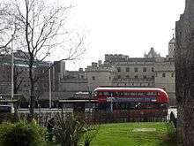
The 2012 Summer Olympics and Paralympics were held in the Olympic Park, created on former industrial land around the River Lea. The park includes a legacy of new sports facilities, housing, industrial and technical infrastructure intended to further regenerate the area.[5] Other developments at Stratford include Stratford International station and the Stratford City development.[55] Nearby, the University of East London developed a new campus, which provided the United States Olympic Team its training base during the 2012 Games.[56]
Politics and social reform
At the end of the 17th century large numbers of Huguenot weavers arrived in the East End, settling to service an industry that grew up around the new estate at Spitalfields, where master weavers were based. They brought with them a tradition of "reading clubs", where books were read, often in public houses. The authorities were suspicious of immigrants meeting and in some ways they were right to be as these grew into workers' associations and political organisations. Towards the middle of the 18th century the silk industry fell into a decline – partly due to the introduction of printed calico cloth – and riots ensued. These "Spitalfield Riots" of 1769 were actually centred to the east and were put down with considerable force, culminating in two men being hanged in front of the Salmon and Ball public house at Bethnal Green. One was John Doyle (an Irish weaver), the other John Valline (of Huguenot descent).[57]
In 1844, an Association for Promoting Cleanliness among the Poor was established, and built a bath-house and laundry in Glasshouse Yard, East Smithfield. This cost a single penny for bathing or washing, and by June 1847 was receiving 4,284 people a year. This led to an Act of Parliament to encourage other municipalities to build their own and the model spread quickly throughout the East End. Timbs noted that "... so strong was the love of cleanliness thus encouraged that women often toiled to wash their own and their children's clothing, who had been compelled to sell their hair to purchase food to satisfy the cravings of hunger".[58]
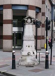
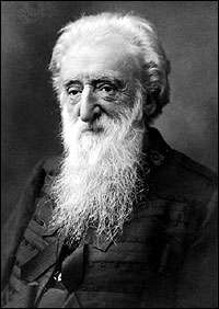
William Booth began his Christian Revival Society in 1865, preaching the gospel in a tent erected in the Friends Burial Ground, Thomas Street, Whitechapel. Others joined his Christian Mission, and on 7 August 1878 the Salvation Army was formed at a meeting held at 272 Whitechapel Road.[59] A statue commemorates both his mission and his work in helping the poor. Dubliner Thomas John Barnardo came to the London Hospital, Whitechapel to train for medical missionary work in China. Soon after his arrival in 1866 a cholera epidemic swept the East End killing 3,000 people. Many families were left destitute, with thousands of children orphaned and forced to beg or find work in the factories. In 1867, Barnardo set up a Ragged School to provide a basic education but was shown the many children sleeping rough. His first home for boys was established at 18 Stepney Causeway in 1870. When a boy died after being turned away (the home was full), the policy was instituted of "No Destitute Child Ever Refused Admission".[60]
In 1884, the Settlement movement was founded, with settlements such as Toynbee Hall[61] and Oxford House, to encourage university students to live and work in the slums, experience the conditions and try to alleviate some of the poverty and misery in the East End. Notable residents of Toynbee Hall included R. H. Tawney, Clement Attlee, Guglielmo Marconi, and William Beveridge. The Hall continues to exert considerable influence, with the Workers Educational Association (1903), Citizens Advice Bureau (1949) and Child Poverty Action Group (1965) all being founded or influenced by it.[62] In 1888, the matchgirls of Bryant and May in Bow went on strike for better working conditions. This, combined with the many dock strikes in the same era, made the East End a key element in the foundation of modern socialist and trade union organisations, as well as the Suffragette movement.[63]
Towards the end of the 19th century, a new wave of radicalism came to the East End, arriving both with Jewish émigrés fleeing from Eastern European persecution, and Russian and German radicals avoiding arrest. A German émigré anarchist, Rudolf Rocker, began writing in Yiddish for Arbayter Fraynd (Workers' Friend). By 1912, he had organised a mass London garment workers' strike for better conditions and an end to "sweating".[64] Amongst the Russians was fellow anarchist Peter Kropotkin who helped found the Freedom Press in Whitechapel. Afanasy Matushenko, one of the leaders of the Potemkin mutiny, fled the failure of the Russian Revolution of 1905 to seek sanctuary in Stepney Green.[65] Leon Trotsky and Vladimir Lenin attended meetings of the newspaper Iskra in 1903. in Whitechapel; and in 1907 Lenin and Joseph Stalin[66][67] attended the Fifth Congress of the Russian Social Democratic Labour Party held in a Hoxton church. That congress consolidated the leadership of Lenin's Bolshevik faction and debated strategy for the communist revolution in Russia.[68] Trotsky noted, in his memoires, meeting Maxim Gorky and Rosa Luxemburg at the conference.[69]
By the 1880s, the casual system caused dock workers to unionise under Ben Tillett and John Burns.[70] This led to a demand for "6d per hour" (the "Docker's Tanner"),[71] and an end to casual labour in the docks.[72] Colonel G. R. Birt, the general manager at Millwall Docks, gave evidence to a Parliamentary committee, on the physical condition of the workers:
The poor fellows are miserably clad, scarcely with a boot on their foot, in a most miserable state.... These are men who come to work in our docks who come on without having a bit of food in their stomachs, perhaps since the previous day; they have worked for an hour and have earned 5d. [2p]; their hunger will not allow them to continue: they take the 5d. in order that they may get food, perhaps the first food they have had for twenty-four hours.
— Col. G. R. Birt, in evidence to the Parliamentary Committee (1889), [72]
These conditions earned dockers much public sympathy, and after a bitter struggle, the London Dock Strike of 1889 was settled with victory for the strikers, and established a national movement for the unionisation of casual workers, as opposed to the craft unions that already existed.
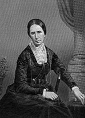
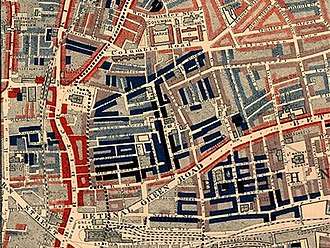
The philanthropist Angela Burdett-Coutts was active in the East End, alleviating poverty by founding a sewing school for ex-weavers in Spitalfields and building the ornate Columbia Market in Bethnal Green. She helped to inaugurate the London Society for the Prevention of Cruelty to Children, was a keen supporter of the Ragged School Union, and operated housing schemes similar to those of the Model Dwellings Companies such as the East End Dwellings Company and the Four Per Cent Industrial Dwellings Company, where investors received a financial return on their philanthropy.[73] Between the 1890s and 1903, when the work was published, the social campaigner Charles Booth instigated an investigation into the life of London poor (based at Toynbee Hall), much of which was centred on the poverty and conditions in the East End.[74] Further investigations were instigated by the Royal Commission on the Poor Laws and Relief of Distress 1905–09, the Commission found it difficult to agree, beyond that change was necessary and produced separate minority and majority reports. The minority report was the work of Booth with the founders of the London School of Economics Sidney and Beatrice Webb. They advocated focusing on the causes of poverty and the radical notion of poverty being involuntary, rather than the result of innate indolence. At the time their work was rejected but was gradually adopted as policy by successive governments.[75]
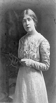
Sylvia Pankhurst became increasingly disillusioned with the suffragette movement's inability to engage with the needs of working-class women, so in 1912 she formed her own breakaway movement, the East London Federation of Suffragettes. She based it at a baker's shop at Bow emblazoned with the slogan, "Votes for Women", in large gold letters. The local Member of Parliament, George Lansbury, resigned his seat in the House of Commons to stand for election on a platform of women's enfranchisement. Pankhurst supported him in this, and Bow Road became the campaign office, culminating in a huge rally in nearby Victoria Park. Lansbury was narrowly defeated in the election, however, and support for the project in the East End was withdrawn. Pankhurst refocused her efforts, and with the outbreak of the First World War, she began a nursery, clinic and cost price canteen for the poor at the bakery. A paper, the Women's Dreadnought, was published to bring her campaign to a wider audience. Pankhurst spent twelve years in Bow fighting for women's rights. During this time, she risked constant arrest and spent many months in Holloway Prison, often on hunger strike. She finally achieved her aim of full adult female suffrage in 1928, and along the way she alleviated some of the poverty and misery, and improved social conditions for all in the East End.[76]
The alleviation of widespread unemployment and hunger in Poplar had to be funded from money raised by the borough itself under the Poor Law. The poverty of the borough made this patently unfair and lead to the 1921 conflict between government and the local councillors known as the Poplar Rates Rebellion. Council meetings were for a time held in Brixton prison, and the councillors received wide support.[77] Ultimately, this led to the abolition of the Poor Laws through the Local Government Act 1929.
The General Strike had begun as a dispute between miners and their employers outside London in 1925. On 1 May 1926 the Trades Union Congress called out workers all over the country, including the London dockers. The government had had over a year to prepare and deployed troops to break the dockers' picket lines. Armed food convoys, accompanied by armoured cars, drove down the East India Dock Road. By 10 May, a meeting was brokered at Toynbee Hall to end the strike. The TUC were forced into a humiliating climbdown and the general strike ended on 11 May, with the miners holding out until November.[78]
World Wars
First World War
In 1915–17, the capital experienced a series of raid by airships of the German Army and Navy.[79] 1917 and 1918 saw a series of raids by fixed wing aircraft. The morning of 13 June 1917 saw the first ever daylight air-raid over the East End, by German Gotha bombers, a raid which killed 104 people. Eighteen died at Upper North Street School, Poplar. A memorial still stands today in Poplar Recreation Ground. During the war a total of 120 children and 104 adults were killed in the East End by aerial bombing, with many more injured.[80]
The largest single loss of life occurred due to an industrial accident a plant producing supplies for the war effort. On 19 January 1917, 73 people died, including 14 workers, and more than 400 were injured, in a TNT explosion in the Brunner-Mond munitions factory in Silvertown. Much of the area was flattened, and the shock wave was felt throughout the city and much of Essex. This was the largest explosion in London history, and was heard in Southampton and Norwich. The explosion happened in the early evening, if it had occurred in the day, or at night then the death toll would have been much greater. Andreas Angel, chief chemist at the plant, was posthumously awarded the Edward Medal for trying to extinguish the fire that caused the blast.[81]
Second World War
Hardest of all, the Luftwaffe will smash Stepney. I know the East End! Those dirty Jews and Cockneys will run like rabbits into their holes.
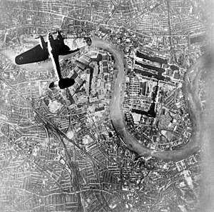
Initially, the German commanders were reluctant to bomb London, fearing retaliation against Berlin. On 24 August 1940, a single aircraft, tasked to bomb Tilbury, accidentally bombed Stepney, Bethnal Green and the City. The following night the RAF retaliated by mounting a forty aircraft raid on Berlin, with a second attack three days later. The Luftwaffe changed its strategy from attacking shipping and airfields to attacking cities. The City and West End were designated "Target Area B"; the East End and docks were "Target Area A". The first raid occurred at 4:30 p.m. on 7 September and consisted of 150 Dornier and Heinkel bombers and large numbers of fighters. This was followed by a second wave of 170 bombers. Silvertown and Canning Town bore the brunt of this first attack.[13]
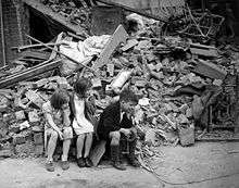
Between 7 September 1940 and 10 May 1941, a sustained bombing campaign was mounted. It began with the bombing of London for 57 successive nights,[83] an era known as "the Blitz". East London was targeted because the area was a centre for imports and storage of raw materials for the war effort, and the German military command felt that support for the war could be damaged among the mainly working class inhabitants. On the first night of the Blitz, 430 civilians were killed and 1,600 seriously wounded.[83] The populace responded by evacuating children and the vulnerable to the country[84] and digging in, constructing Anderson shelters in their gardens and Morrison shelters in their houses, or going to communal shelters built in local public spaces.[85] On 10 September 1940, 73 civilians, including women and children preparing for evacuation, were killed when a bomb hit the South Hallsville School. Although the official death toll is 73,[86] many local people believed it must have been higher. Some estimates say 400 or even 600 may have lost their lives during this raid on Canning Town.[87]
The effect of the intensive bombing worried the authorities and Mass-Observation was deployed to gauge attitudes and provide policy suggestions,[88] as before the war they had investigated local attitudes to anti-Semitism.[89] The organisation noted that close family and friendship links within the East End were providing the population with a surprising resilience under fire. Propaganda was issued, reinforcing the image of the "brave chirpy Cockney". On the Sunday after the Blitz began, Winston Churchill himself toured the bombed areas of Stepney and Poplar. Anti-aircraft installations were built in public parks, such as Victoria Park and the Mudchute on the Isle of Dogs, and along the line of the Thames, as this was used by the aircraft to guide them to their target.
The authorities were initially wary of opening the London Underground for shelter, fearing the effect on morale elsewhere in London and hampering normal operations. On 12 September, having suffered five days of heavy bombing, the people of the East End took the matter into their own hands and invaded tube stations with pillows and blankets. The government relented and opened the partially completed Central line as a shelter. Many deep tube stations remained in use as shelters until the end of the war.[13] Aerial mines were deployed on 19 September 1940. These exploded at roof top height, causing severe damage to buildings over a wider radius than the impact bombs. By now, the Port of London had sustained heavy damage with a third of its warehouses destroyed, and the West India and St Katherine Docks had been badly hit and put out of action. Bizarre events occurred when the River Lea burned with an eerie blue flame, caused by a hit on a gin factory at Three Mills, and the Thames itself burnt fiercely when Tate & Lyle's Silvertown sugar refinery was hit.[13]
On 3 March 1943 at 8:27 p.m., the unopened Bethnal Green Underground station was the site of a wartime disaster. Families had crowded into the underground station due to an air-raid siren at 8:17, one of 10 that day. There was a panic at 8:27 coinciding with the sound of an anti-aircraft battery (possibly the recently installed Z battery) being fired at nearby Victoria Park. In the wet, dark conditions, a woman slipped on the entrance stairs and 173 people died in the resulting crush. The truth was suppressed, and a report appeared that there had been a direct hit by a German bomb. The results of the official investigation were not released until 1946.[90] There is now a plaque at the entrance to the tube station, which commemorates the event as the "worst civilian disaster of World War II". The first V-1 flying bomb struck in Grove Road, Mile End, on 13 June 1944, killing six, injuring 30, and making 200 people homeless.[20] The area remained derelict for many years until it was cleared to extend Mile End Park. Before demolition, local artist Rachel Whiteread made a cast of the inside of 193 Grove Road. Despite attracting controversy, the exhibit won her the Turner Prize for 1993.[91]

It is estimated that by the end of the war, 80 tons of bombs had fallen on the Metropolitan Borough of Bethnal Green alone, affecting 21,700 houses, destroying 2,233 and making a further 893 uninhabitable. In Bethnal Green, 555 people were killed, and 400 were seriously injured.[26] For the whole of Tower Hamlets, a total of 2,221 civilians were killed, and 7,472 were injured, with 46,482 houses destroyed and 47,574 damaged.[92] So badly battered was the East End that when Buckingham Palace was hit during the height of the bombing, Queen Elizabeth (the future Queen Mother) observed that "It makes me feel I can look the East End in the face."[93][94] By the end of the war, the East End was a scene of devastation, with large areas derelict and depopulated. War production was changed quickly to making prefabricated houses,[95] and many were installed in the bombed areas and remained common into the 1970s. Today, 1950s and 1960s architecture dominates the housing estates of the area such as the Lansbury Estate in Poplar, much of which was built as a show-piece of the 1951 Festival of Britain.[96]
Culture and Community
Cockney identity
Despite a negative image among outsiders, the people of the area take pride in the East End and in their Cockney identity. The term Cockney has loose geographic and linguistic definitions with blurring between the two. In practice people from all over the East End, the wider East London area and sometimes beyond, identify as Cockneys; some of these use the Cockney dialect to some degree and others not.
A traditional definition is that to be a Cockney, one had to be born within the sound of Bow Bells, situated on Cheapside. In general, the sound pattern would cover most of the City, and parts of the near East End such as Aldgate and Whitechapel, but it is unlikely that the bells would have been heard in the docklands. In practice, with Royal London the only maternity hospital nearby, few would today be born within earshot.
The Cockney dialect has lexical borrowings from Yiddish, Romani, and costermonger slang, and a distinctive accent that includes T-glottalization, a loss of dental fricatives, diphthong alterations, the use of rhyming slang and other features. The accent is said to be a remnant of early English London speech, modified by the many immigrants to the area.[97] Cockney English is spoken widely in the East End, other areas of East London and in many traditionally working-class areas across London.
The position of the Cockney dialect in London has been weakened by the promotion of Received Pronunciation (RP) in the 20th century, and by the scale of migration to London. This has included both gentrifying domestic migration (RP speakers) and the scale of international migration. Conversely, out-migration from East London has spread the Cockney dialect beyond the capital.
The Cockney dialect taken beyond London is sometimes referred to as Estuary English, heavily influenced by Cockney and named after the Thames Estuary area where the movement of East Londoners to south Essex and to a lesser extent parts on north Kent led it to be most widely spoken.[98] Within London Cockney speech is, to a significant degree, being replaced by Multicultural London English, a form of speech with a significant Cockney influence.
Bells
In 1360, Geoffrey Chaucer, then living in the City Wall's Aldgate gatehouse, recorded a pre-existing bell-founding industry, outside the wall in the Aldgate\Whitechapel area.
Two of the six sets of bells featured in the Nursery rhyme Oranges and Lemons are in the East End (Whitechapel and Shoreditch), as well as that symbol of the East End - Bow Bells (at St Mary-le-Bow on Cheapside, within the former walls and therefore outside of the East End). Older versions of the rhyme include the bells at Aldgate, though this may instead reference the bell founding industry in that area. The Shoreditch bells that feature in the rhyme are used to represent Shoreditch in the Coat of arms of the London Borough of Hackney.

The Whitechapel Bell Foundry opened in 1570, and until its closure in 2016 was the oldest manufacturing company in the UK.[99] The foundry built many of the most famous bells in the world including Big Ben, the Liberty Bell in Philadelphia and Bow Bells. Other Whitechapel cast bells of local significance include St Dunstan's in Stepney, and the parish churches of West Ham and Hackney. The Olympic Bell at the London Stadium – the largest harmonically tuned bell in the world and used in the opening ceremony of the 2012 games was jointly developed by Whitechapel, in partnership with a Dutch foundry.
St Dunstan and Stepney
Dunstan was a tenth century churchman, statesman and saint with strong links to the East End area. As Bishop of London he was also the Lord of the Manor of Stepney, an estate that included most or all of what would become the East End, and like subsequent bishops may have lived in the manor. The extent of the manor, and the association with the Tower means the Tower division, also known as the Tower Hamlets may have been based on Stepney.[100]

In 952, Dunstan is recorded as founding (or rebuilding) St Dunstan's Church in Stepney. This was initially the only church for the Parish of Stepney which, like the manor, originally included much or all of the East End area, with daughter parishes forming much later as a result of population growth. For this reason, St Dunstan's is known as The Mother Church of the East End [101] (not to be confused with St Mark's in Dalston, known as the Cathedral of the East End due to its size). As patron of Stepney, Dunstan is the closest East London has to a patron saint. He is also the patron saint of bell ringers and various types of metalworker. His feast day is 19 May.
A folk story about Dunstan is that the devil, in the guise of a beautiful woman, came to tempt Dunstan - a talented metalworker - while he was working in his forge. Dunstan spotted hooves under the skirt, realised that it was the devil, so took his red-hot tongs from the fire and grabbed the devil by the nose, causing him intense pain. The fire-tongs have become a symbol of St Dunstan. The encounter is commonly referenced in English literature, for instance A Christmas Carol and in the folk rhyme:
St Dunstan, as the story goes,
Once pull'd the devil by the nose
With red-hot tongs, which made him roar,
That he was heard three miles or more.[102]
Dunstan's links to the area led to his fire-tong symbol being included in the coat of arms of the Metropolitan Borough of Stepney, and the arms of its successor, the modern London Borough of Tower Hamlets.
Brick Lane Mosque
Throughout its history, the East End has evolved in response to economic and social change, including migration, with its population being joined by large numbers of people from the UK and overseas. This is exemplified by the Brick Lane Mosque.[103][104]
The mosque was first built as a church by Huguenot Protestant refugees who came to East London to escape persecution in France. After much of that community moved on from the Spitalfields area it was used as a Methodist chapel for a more widely based Christian congregation. It later became a synagogue, used by Jewish people who came to avoid pogroms in the Russian Empire and other parts of Europe. The Jewish community of the area dwindled, and in 1976 the building was taken on by the local Bengali community and is now used as a mosque.
Military contribution

The Tower Division (also known as the Tower Hamlets), was a part of Middlesex, but managed the reserve forces and other county functions itself; it was independent of the Lord Lieutenant of Middlesex, having its own Lord Lieutenant, the Constable of the Tower. The Tower Hamlets men, or Hamleteers, were needed to supplement the Tower of London's small Yeoman Warder garrison at times of heightened international of domestic tension. The first surviving reference to the service owed to the Tower dates to 1554, but it describes pre-existing obligations, so the association is likely to be considerably older.[105]
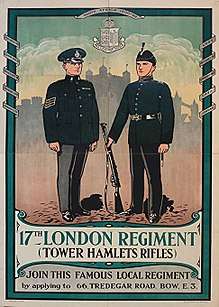
Local forces continued to be primarily based on the Tower Division until its abolishment in 1900, though Tower Hamlets units remained part of the army until 1967. During the twentieth century, army units were generally based on more local areas, for instance the Poplar and Stepney Rifles. The First World War saw a proliferation of local battalions, including several “Pals” units, but this representation was reduced in the Second World War due to the smaller size of the army and the reduced emphasis on units with small recruitment areas.
Pearlies
The Pearly Kings and Queens, or more usually pearlies, are a traditional part of London costermonger culture, their name derives from their clothes which are decorated with mother-of-pearl buttons.

The pearlies are described as the ‘aristocracy‘ of the costermongers and were originally elected by them to safeguard their rights from competitors and ‘roughs’. They are now devoted entirely to charitable activities.[106] Pearlies are part of the East End's heritage, but contrary to the widespread perception, they are not an exclusively East End institution, there are Pearly Kings and Queens across inner London. A parade of real-life Pearly Kings and Queens was featured at the 2012 Summer Olympics Opening Ceremony.
Population
.jpg)
Throughout history the area has absorbed waves of immigrants, who have added new dimensions to its culture and history, most notably the French Protestant Huguenots in the 17th century,[1] the Irish in the 18th century,[2] Ashkenazi Jews fleeing pogroms in Eastern Europe towards the end of the 19th century,[3] and the Sylheti Bangladeshis[4] community in the 1960s.
Immigration
Immigrant communities first developed in the riverside settlements. From the Tudor era until the 20th century, ships' crews were employed on a casual basis. New and replacement crew would be found wherever they were available, local sailors being particularly prized for their knowledge of currents and hazards in foreign ports. Crews were paid at the end of their voyages. Inevitably, permanent communities became established, including colonies of Lascars and Africans from the Guinea Coast. Large Chinatowns at both Shadwell and Limehouse developed, associated with the crews of merchantmen in the opium and tea trades. It was only after the devastation of the Second World War that this predominantly Han Chinese community relocated to Soho.[108]
In 1786, the Committee for the Relief of the Black Poor was formed by citizens concerned at the size of London's indigent Black population, many of whom had been expelled from North America as Black Loyalists — former slaves who had fought on the side of the British in the American Revolutionary War. Others were discharged sailors and some a legacy of British involvement in the slave trade. The committee distributed food, clothing, and medical aid and found work for men, from various locations including the White Raven tavern in Mile End.[109] They also helped the men to go abroad, some to Canada. In October 1786, the Committee funded an ill-fated expedition of 280 black men, 40 black women and 70 white women (mainly wives and girlfriends) to settle in Sierra Leone.[110] From the late 19th century, a large African mariner community was established in Canning Town as a result of new shipping links to the Caribbean and West Africa.[111]
Immigrants have not always been readily accepted. In 1517 the Evil May Day riots, in which foreign-owned property was attacked, resulted in the deaths of 135 Flemings in Stepney. The Gordon Riots of 1780 began with burnings of the houses of Catholics and their chapels in Poplar and Spitalfields.[112]
.jpg)
In the 1870s and 1880s, so many Jewish émigrés were arriving that over 150 synagogues were built. Today four active synagogues remain in Tower Hamlets: the Congregation of Jacob Synagogue (1903 – Kehillas Ya'akov), the East London Central Synagogue (1922), the Fieldgate Street Great Synagogue (1899) and Sandys Row Synagogue (1766).[113] Jewish immigration to the East End peaked in the 1890s, leading to anti-foreigner agitation by the British Brothers League, formed in 1902 by Captain William Stanley Shaw and the Conservative MP for Stepney, Major Evans-Gordon, who had overturned a Liberal majority in the 1900 General Election on a platform of limiting immigration. In Parliament in 1902, Evans-Gordon claimed that "not a day passes but English families are ruthlessly turned out to make room for foreign invaders. The rates are burdened with the education of thousands of foreign children."[114] Jewish immigration slowed only with the passing of the Aliens Act 1905, which gave the Home Secretary powers to regulate and control immigration.[115]
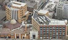
At the beginning of the 20th century, London was the capital of the extensive British Empire, which contained tens of millions of Muslims, but London had no mosque for Muslim residents or visitors. On 9 November 1910, at a meeting of Muslims and non-Muslims at the Ritz Hotel, the London Mosque Fund was established with the aims of organising weekly Friday prayers and providing a permanent place of worship for Muslims in London.[116] From 1910 to 1940 various rooms had been hired for Jumu'ah prayers on Fridays. Finally, in 1940, three houses were purchased at 446–448 Commercial Road in the East End of London as a permanent place of prayer. On 2 August 1941 the combined houses were inaugurated as the East London Mosque and Islamic Culture Centre at a ceremony attended by the Egyptian Ambassador, Colonel Sir Gordon Neal (representing the Secretary of State for India). The first prayer was led by the Ambassador for Saudi Arabia, Shaikh Hafiz Wahba.[117] From the late 1950s the local Muslim population began to increase due to further immigration from the Indian subcontinent, particularly from Sylhet in East Pakistan, which became Bangladesh in 1971. The migrants settled in areas already established by the Sylheti expatriate community, working in the local docks and Jewish tailoring shops set up in the days of British India.[118] During the 1970s, this immigration increased significantly. In 1975 the local authority bought the properties in Commercial Road under a compulsory purchase order, in return providing a site with temporary buildings on Whitechapel Road. The local community set about raising funds to erect a purpose-built mosque on the site. King Fahd of Saudi Arabia donated £1.1 million of the £2 million fund,[119] and the governments of Kuwait and Britain also donated to the fund.[120] Seven years later, the building of the new mosque commenced, with foundations laid in 1982 and construction completed in 1985. It was one of the first mosques in the European Union to broadcast the adhan from the minaret using loudspeakers. Currently, the mosque has a capacity of 7,000, with prayer areas for men and women and classroom space for supplementary education. By the 1990s the capacity was already insufficient for the growing congregation and the range of projects based there.[121] The contribution of Bangladeshi people to British life was recognised in 1998, when Pola Uddin, Baroness Uddin of Bethnal Green became the first Bangladeshi-born Briton to enter the House of Lords and the first Muslim peer to swear her oath of allegiance in the name of her own faith.
Community tensions were again raised by an antisemitic Fascist march that took place in 1936 and was blocked by residents and activists at the Battle of Cable Street.[122] From the mid-1970s anti-Asian violence occurred,[123] culminating in the murder on 4 May 1978 of 25-year-old clothing worker Altab Ali by three white teenagers in a racially motivated attack. Bangladeshi groups mobilised for self-defence, 7,000 people marched to Hyde Park in protest, and the community became more politically involved.[124] The former churchyard of St Mary's Whitechapel, near where the attack took place, was renamed "Altab Ali Park" in 1998 in commemoration of his death. Racial tension has continued with occasional outbreaks of violence, and in 1993 the British National Party won a council seat (since lost).[125] A 1999 bombing in Brick Lane was part of a series that targeted ethnic minorities, gays and "multiculturalists".[126]
Outward migration: the Cockney diaspora
As London extended east, East Enders often moved to opportunities in the new suburbs. The late 19th century saw a major movement of people to West Ham[40] and East Ham[41] to service the new docks and industries established there.
There was significant work to alleviate overcrowded housing from the start of the 20th century under the London County Council. Between the wars, people moved to new estates built for this purpose, in particular at Becontree and Harold Hill, or out of London entirely.
The Second World War devastated much of the East End, with its docks, railways and industry forming a continual target for bombing, especially during the Blitz, leading to dispersal of the population to new suburbs and new housing being built in the 1950s.[13] Many East Enders went further than the eastern suburbs, leaving London altogether, notably to the Essex new towns of Basildon and Harlow and a number of expanded towns in south Essex and elsewhere.
The resulting depopulation accelerated after the Second World War and has only recently begun to reverse.
These population figures reflect the area that now forms the London Borough of Tower Hamlets only:
| Borough | 1811[127] | 1841[127] | 1871[127] | 1901[128] | 1931[128] | 1961[128] | 1971[129] | 1991[130] | 2001[131] |
|---|---|---|---|---|---|---|---|---|---|
| Bethnal Green | 33,619 | 74,088 | 120,104 | 129,680 | 108,194 | 47,078 | n/a | n/a | n/a |
| Poplar | 13,548 | 31,122 | 116,376 | 168,882 | 155,089 | 66,604 | |||
| Stepney | 131,606 | 203,802 | 275,467 | 298,600 | 225,238 | 92,000 | |||
| Total | 178,773 | 309,012 | 511,947 | 597,102 | 488,611 | 205,682 | 169,626 | 161,064 | 196,106 |
By comparison, in 1801 the population of England and Wales was 9 million; by 1851 it had more than doubled to 18 million, and by the end of the century had reached 40 million.[20] Today, Bangladeshis form the largest minority population in Tower Hamlets, constituting 33.5% of the borough's population at the 2001 census; the Bangladeshi community there is the largest such community in Britain.[132] The 2006 estimates show a decline in this group to 29.8% of the population, reflecting a movement to better economic circumstances and the larger houses available in the eastern suburbs.[133] In this, the latest group of migrants are following a pattern established for over three centuries.
Crime
The high levels of poverty in the East End have, throughout history, corresponded with a high incidence of crime. From earliest times, crime depended, as did labour, on the importing of goods to London, and their interception in transit. Theft occurred in the river, on the quayside and in transit to the City warehouses. This was why, in the 17th century, the East India Company built high-walled docks at Blackwall and had them guarded to minimise the vulnerability of their cargoes. Armed convoys would then take the goods to the company's secure compound in the City. The practice led to the creation of ever-larger docks throughout the area, and large roads to drive through the crowded 19th century slums to carry goods from the docks.[13]
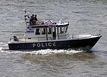
No police force operated in London before the 1750s. Crime and disorder were dealt with by a system of magistrates and volunteer parish constables, with strictly limited jurisdiction. Salaried constables were introduced by 1792, although they were few in number and their power and jurisdiction continued to derive from local magistrates, who in extremis could be backed by militias. In 1798, England's first Marine Police Force was formed by magistrate Patrick Colquhoun and a Master Mariner, John Harriott, to tackle theft and looting from ships anchored in the Pool of London and the lower reaches of the river. Its base was (and remains) in Wapping High Street. It is now known as the Marine Support Unit.[134]
In 1829, the Metropolitan Police Force was formed, with a remit to patrol within 7 miles (11 km) of Charing Cross, with a force of 1,000 men in 17 divisions, including 'H' division, based in Stepney. Each division was controlled by a superintendent, under whom were four inspectors and sixteen sergeants. The regulations demanded that recruits should be under thirty-five years of age, well built, at least 5-foot-7-inch (1.70 m) in height, literate and of good character.[135]
Unlike the former constables, the police were recruited widely and financed by a levy on ratepayers; so they were initially disliked. The force took until the mid-19th century to be established in the East End. Unusually, Joseph Sadler Thomas, a Metropolitan Police superintendent of "F" (Covent Garden) Division, appears to have mounted the first local investigation (in Bethnal Green), in November 1830 of the London Burkers.[136] A specific Dockyard division of the Metropolitan force was formed to assume responsibility for shore patrols within the docks in 1841,[137] a detective department was formed in 1842, and in 1865, "J" division was established in Bethnal Green.[135]
One of the East End industries that serviced ships moored off the Pool of London was prostitution, and in the 17th century, this was centred on the Ratcliffe Highway, a long street lying on the high ground above the riverside settlements. In 1600, it was described by the antiquarian John Stow as "a continual street, or filthy straight passage, with alleys of small tenements or cottages builded, inhabited by sailors and victuallers". Crews were paid off at the end of a long voyage, and would spend their earnings on drink in the local taverns.[138]
One madame described as "the great bawd of the seamen" by Samuel Pepys was Damaris Page. Born in Stepney in approximately 1610, she had moved from prostitution to running brothels, including one on the Highway that catered for ordinary seaman and a further establishment nearby that catered for the more expensive tastes amongst the officers and gentry. She died wealthy, in 1669, in a house on the Highway, despite charges being brought against her and time spent in Newgate Prison.[138][139]
By the 19th century, an attitude of toleration had changed, and the social reformer William Acton described the riverside prostitutes as a "horde of human tigresses who swarm the pestilent dens by the riverside at Ratcliffe and Shadwell". The Society for the Suppression of Vice estimated that between the Houndsditch, Whitechapel and Ratcliffe areas there were 1803 prostitutes; and between Mile End, Shadwell and Blackwall 963 women in the trade. They were often victims of circumstance, there being no welfare state and a high mortality rate amongst the inhabitants that left wives and daughters destitute, with no other means of income.[140]
At the same time, religious reformers began to introduce "seamens' missions" throughout the dock areas that sought both to provide for seafarers' physical needs and to keep them away from the temptations of drink and women. Eventually, the passage of the Contagious Diseases Prevention Act in 1864 allowed policemen to arrest prostitutes and detain them in hospital. The act was repealed in 1886, after agitation by early feminists, such as Josephine Butler and Elizabeth Wolstenholme, led to the formation of the Ladies National Association for the Repeal of the Contagious Diseases Acts.[141]
Notable crimes in the area include the Ratcliff Highway murders (1813);[142] the killings committed by the London Burkers (apparently inspired by Burke and Hare) in Bethnal Green (1831);[143] the notorious serial killings of prostitutes by Jack the Ripper (1888);[63] and the Siege of Sidney Street (1911) (in which anarchists, inspired by the legendary Peter the Painter, took on Home Secretary Winston Churchill, and the army).[144]
In the 1960s the East End was the area most associated with gangster activity, most notably that of the Kray twins.[145] The 1996 Docklands bombing caused significant damage around South Quay Station, to the south of the main Canary Wharf development. Two people were killed and thirty-nine injured in one of Mainland Britain's biggest bomb attacks by the Provisional Irish Republican Army.[146] This led to the introduction of police checkpoints controlling access to the Isle of Dogs, reminiscent of the City's "ring of steel'"
Peacetime disasters
As a maritime port, plague and pestilence has fallen on East Enders disproportionately. The area most afflicted by the Great Plague (1665) was Spitalfields,[147] and cholera epidemics broke out in Limehouse in 1832 and struck again in 1848 and 1854.[112] Typhus and tuberculosis were common in the crowded 19th century tenements.
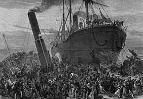
The Princess Alice was a passenger steamer crowded with day trippers returning from Gravesend to Woolwich and London Bridge. On the evening of 3 September 1878, she collided with the steam collier Bywell Castle and sank into the Thames in under four minutes. Of the approximately 700 passengers, over 600 were lost.[148]
.jpg)
In 1898 a great loss of life occurred when HMS Albion was launched at the Thames Ironworks shipyard at Bow Creek. The ship's entry into the water created a huge displacement wave which caused a crowded pier to collapse into the water. Large crowds had been watching the launch, a moment of celebration for the community, and 38 people, mostly women and children were drowned.[149][150]
Another tragedy occurred on the morning of 16 May 1968 when Ronan Point, a 23-storey tower block in Newham, suffered a structural collapse due to a gas explosion. Four people were killed in the disaster and seventeen were injured, as an entire corner of the building slid away. The collapse caused major changes in UK building regulations and led to the decline of further building of high rise council flats that had characterised 1960s public architecture.[151]
Entertainment

In 1574 the City authorities banned the building of playhouses in the City of London area, consequently theatres were built in the suburbs, beyond its jurisdiction.[152] This led to the East End, notably Shoreditch, becoming a major centre of the Elizabethan Theatre, existing venues were joined by a number of additions.
Inn-yard theatres were first established in the Tudor period, with the Boar's Head Inn (1557) in Whitechapel, the George in Stepney and a purpose built, but short lived, John Brayne's Red Lion Theatre (1567), nearby.[153] The first permanent theatres with resident companies were constructed in Shoreditch, with James Burbage's The Theatre (1576) and Henry Lanman's Curtain Theatre (1577) standing close together. On the night of 28 December 1598 Burbage's sons dismantled The Theatre, and moved it piece by piece across the Thames to construct the Globe Theatre.[154]
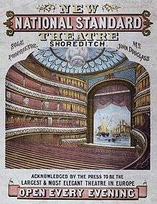
The Goodman's Fields Theatre was established in 1727, and it was here that David Garrick made his successful début as Richard III, in 1741. In the 19th century the theatres of the East End rivalled in their grandiosity and seating capacity those of the West End. The first of this era was the ill-fated Brunswick Theatre (1828), which collapsed three days after opening, killing 15 people. This was followed by the opening of the Pavilion Theatre, Whitechapel (1828), the Garrick (1831) in Leman Street, the Effingham (1834) in Whitechapel, the Standard (1835) in Shoreditch, the City of London (1837) in Norton Folgate, then the Grecian and the Britannia Theatre in Hoxton (1840).[155] Though very popular for a time, from the 1860s onwards these theatres, one by one, began to close, the buildings were demolished and their very memory began to fade.[156]
There were also many Yiddish theatres, particularly around Whitechapel. These developed into professional companies, after the arrival of Jacob Adler in 1884 and the formation of his Russian Jewish Operatic Company that first performed in Beaumont Hall,[157] Stepney, and then found homes both in the Prescott Street Club, Stepney, and in Princelet Street in Spitalfields.[158] The Pavilion became an exclusively Yiddish theatre in 1906, finally closing in 1936 and being demolished in 1960. Other important Jewish theatres were Feinmans, The Jewish National Theatre and the Grand Palais. Performances were in Yiddish, and predominantly melodrama.[113] These declined, as audience and actors left for New York and the more prosperous parts of London.[159]
The once popular music halls of the East End have mostly met the same fate as the theatres. Prominent examples included the London Music Hall (1856–1935), 95-99 Shoreditch High Street, and the Royal Cambridge Music Hall (1864–1936), 136 Commercial Street. An example of a "giant pub hall", Wilton's Music Hall (1858), remains in Grace's Alley, off Cable Street and the early "saloon style" Hoxton Hall (1863) survives in Hoxton Street, Hoxton.[160] Many popular music hall stars came from the East End, including Marie Lloyd.
The music hall tradition of live entertainment lingers on in East End public houses, with music and singing. This is complemented by less respectable amusements such as striptease, which, since the 1950s has become a fixture of certain East End pubs, particularly in the area of Shoreditch, despite being a target of local authority restraints.[161]

Novelist and social commentator Walter Besant proposed a "Palace of Delight"[162] with concert halls, reading rooms, picture galleries, an art school and various classes, social rooms and frequent fêtes and dances. This coincided with a project by the philanthropist businessman, Edmund Hay Currie to use the money from the winding up of the Beaumont Trust,[163] together with subscriptions to build a "People's Palace" in the East End. Five acres of land were secured on the Mile End Road, and the Queen's Hall was opened by Queen Victoria on 14 May 1887. The complex was completed with a library, swimming pool, gymnasium and winter garden, by 1892, providing an eclectic mix of populist entertainment and education. A peak of 8000 tickets were sold for classes in 1892, and by 1900, a Bachelor of Science degree awarded by the University of London was introduced.[164] In 1931, the building was destroyed by fire, but the Draper's Company, major donors to the original scheme, invested more to rebuild the technical college and create Queen Mary's College in December 1934.[165] A new 'People's Palace' was constructed, in 1937, by the Metropolitan Borough of Stepney, in St Helen's Terrace. This finally closed in 1954.[166]
Professional theatre returned briefly to the East End in 1972, with the formation of the Half Moon Theatre in a rented former synagogue in Aldgate. In 1979, they moved to a former Methodist chapel, near Stepney Green and built a new theatre on the site, opening in May 1985, with a production of Sweeney Todd. The theatre enjoyed success, with premières by Dario Fo, Edward Bond and Steven Berkoff, but by the mid-1980s, the theatre suffered a financial crisis and closed. After years of disuse, it has been converted to a public house.[167] The theatre spawned two further arts projects: the Half Moon Photography Workshop, exhibiting in the theatre and locally, and from 1976 publishing Camerwork,[168] and the Half Moon Young People's Theatre, which remains active in Tower Hamlets.[169]
There are three professional football clubs in the East End area; West Ham United, Leyton Orient and Dagenham and Redbridge. Leyton Orient and West Ham have roots in the maritime trades, with Orient having had links to the Orient Steam Navigation Company[170] while West Ham originated as the works team of the Thames Ironworks and also had links to the Castle Shipping Line. Dagenham and Redbridge was formed by the merger of four clubs, from across East London, with a lineage dating back to 1881.
There are not strong rivalries between the three clubs, instead there is a degree of overlap in support. By contrast, the rivalry between West Ham and Millwall is one of the fiercest in English football. Millwall, originated in the Isle of Dogs, but moved from East London to Bermondsey, South London in 1910. The rivalry between West Ham and Millwall is known as the Dockers Derby, as both clubs traditionally drew much of their support from the dockyards that once lay on either side of the Thames.
In 1966, three West Ham players (Bobby Moore from Barking, Martin Peters from Plaistow and Geoff Hurst from Chelmsford) were major contributors as England won the World Cup, beating West Germany in extra-time at Wembley. West Hams anthem I'm Forever Blowing Bubbles was used in the 2012 Olympic Opening Ceremony for the London Olympics of 2012, with director Danny Boyle remarking that he couldn't tell the story of the East End without reference to the club.
Outside perception
Reputation
Society at large viewed the East End with a mixture of suspicion and fascination, with the use of the term East End in a pejorative sense beginning in the late 19th century,[171] as the expansion of London's population led to extreme overcrowding throughout the area and a concentration of poor people and immigrants.[21] The problems were exacerbated with the construction of St Katharine Docks (1827)[172] and the central London railway termini (1840–1875) that caused the clearance of former slums and rookeries, with many of the displaced people moving into the East End. Over the course of a century, the East End became synonymous with poverty, overcrowding, disease and criminality.[13]
[The] invention about 1880 of the term "East End" was rapidly taken up by the new halfpenny press, and in the pulpit and the music hall ... A shabby man from Paddington, St Marylebone or Battersea might pass muster as one of the respectable poor. But the same man coming from Bethnal Green, Shadwell or Wapping was an "East Ender", the box of Keating's bug powder must be reached for, and the spoons locked up. In the long run this cruel stigma came to do good. It was a final incentive to the poorest to get out of the "East End" at all costs, and it became a concentrated reminder to the public conscience that nothing to be found in the "East End" should be tolerated in a Christian country.
— The Nineteenth Century XXIV (1888)[173]
This idea of the East End as lying beyond the pale of respectability was also emphasised by Jack London when he visited London in 1902, and found that his Hackney carriage driver claimed not to know it. London observed: "Thomas Cook and Son, path-finders and trail-clearers, living sign-posts to all the World.... knew not the way to the East End".[174]
Popular culture

The East End has been the subject of parliamentary commissions and other examinations of social conditions since the 19th century, as seen in Henry Mayhew's London Labour and the London Poor (1851)[175] and Charles Booth's Life and Labour of the People in London (third, expanded edition 1902–3, in 17 volumes).[74] Arthur Morrison's novel A Child of the Jago (1896) is set in Bethnal Green, and recounts the story of a boy growing up in a slum surrounding Arnold Circus.[176] Narrative accounts of experiences amongst the East End poor were also written by Jack London in The People of the Abyss (1903), by George Orwell in parts of his novel Down and Out in Paris and London, recounting his own experiences in the 1930s, as well as the Jewish writer Emanuel Litvinoff in his autobiographical novel Journey Through a Small Planet set in the 1930s. A further detailed study of Bethnal Green was carried out in the 1950s by sociologists Michael Young and Peter Willmott, in Family and Kinship in East London.[177]
Themes from these social investigations have been drawn out in fiction.[12] Crime, poverty, vice, sexual transgression, drugs, class-conflict and multi-cultural encounters and fantasies involving Jewish, Chinese and Indian immigrants are major themes. Though the area has been productive of local writing talent, from the time of Oscar Wilde's The Picture of Dorian Gray (1891) the idea of 'slumming it' in the 'forbidden' East End has held a fascination for a coterie of the literati.[178]
The image of the East Ender changed dramatically between the 19th century and the 20th. From the 1870s they were characterised in culture as often shiftless, untrustworthy and responsible for their own poverty.[177] However, many East Enders worked in lowly but respectable occupations such as carters, porters and costermongers. This latter group particularly became the subject of music hall songs at the turn of the 20th century, with performers such as Marie Lloyd, Gus Elen and Albert Chevalier establishing the image of the humorous East End Cockney and highlighting the conditions of ordinary workers.[179] This image, buoyed by close family and social links and the community's fortitude in the war, came to be represented in literature and film. However, with the rise of the Kray twins in the 1960s the dark side of East End character returned with a new emphasis on criminality and gangsterism.
The success of Jennifer Worth's memoir Call the Midwife (2002, reissued 2007), which became a major best-seller and was adapted by the BBC into their most popular new programme since the current ratings system began,[180] has led to a high level of interest in true-life stories from the East End. Melanie McGrath's Silvertown (2003), about her grandmother's life in the East End, was also a best-seller, as was the follow-up Hopping, about the annual East Enders' 'holiday' hop-picking in Kent.[181] A raft of similar books was published in the 2000s, among them Gilda O'Neill's best-selling Our Street (2004),[182] Piers Dudgeon's Our East End (2009), Jackie Hyam's Bombsites and Lollipops (2011) and Grace Foakes' Four Meals for Fourpence (reprinted 2011). In 2012, HarperCollins published The Sugar Girls, a book which tells the true stories of women working at Tate & Lyle's factories in Silvertown since 1944. The authors commented that many of the East Enders they interviewed were unhappy with the way their neighbourhoods had previously been portrayed in books and on screen – as squalid and criminal, in the Dickensian vein,[183] and as a result they were keen to emphasise the positive aspects of East End life and community.[184] 2012 also saw the publication of Spitalfields Life, a book adapted from the very successful blog of the same name, in which 'the gentle author' (who is anonymous) writes about, and celebrates, the lives of the men and women who live and work in the East End community of Spitalfields.[185]
See also
- Arrival of black immigrants in London
- Historical immigration to Great Britain
- History of Bangladeshis in the United Kingdom
- West End of London
Museums of local history
References
- Bethnal Green: Settlement and Building to 1836, A History of the County of Middlesex: Volume 11: Stepney, Bethnal Green (1998), pp. 91–5. Date accessed: 17 April 2007
- Irish in Britain John A. Jackson, pp. 137–9, 150 (Routledge & Kegan Paul, 1964)
- The Jews A History of the County of Middlesex: Volume 1: Physique, Archaeology, Domesday, Ecclesiastical Organization, The Jews, Religious Houses, Education of Working Classes to 1870, Private Education from Sixteenth Century (1969), pp. 149–51. Date accessed: 17 April 2007
- The Spatial Form of Bangladeshi Community in London's East End Iza Aftab (UCL) (particularly background of Bangladeshi immigration to the East End). Date accessed: 17 April 2007
- Olympic Park: Legacy (London 2012) accessed 20 September 2007 Archived 19 August 2007 at the Wayback Machine
- Chris Hammett Unequal City: London in the Global Arena (2003) Routledge ISBN 0-415-31730-4
- Guide to tours of the Jewish East End published by LBTH, 2003, https://www.towerhamlets.gov.uk/Documents/Leisure-and-culture/Tourism/Visitor-information/Jewish-East-End-walk-leaflet.pdf
- Marriot, John (2011). Beyond the Tower: a history of East London. New Haven: Yale University Press. ISBN 9786613303776. This book includes references from the 18th century onwards that describe Bishopsgate Without as an East End district.
- The New Oxford Dictionary of English (1998) ISBN 0-19-861263-X – p.582 "East End the part of London east of the City as far as the River Lea, including the Docklands".
- Tames, Richard (2004). East End Past. London: Historical Publications. ISBN 9780948667947., treats the area as coextensive with Tower Hamlets, while acknowledging that this excludes parts of the London Borough of Hackney, such as Shoreditch and Hoxton, which many would regard as belonging to the East End.
- Fishman 1988, p. xi, identifies his area of study as Tower Hamlets.
- Newland, Paul (2008). The Cultural Construction of London's East End. Amsterdam: Rodopi. ISBN 9789042024540.
- Palmer, Alan (1989). The East End. London: John Murray. ISBN 0-7195-5666-X.
- "Londoners Over the Border", in Household Words Charles Dickens 390 Archived 24 October 2007 at the Wayback Machine 12 September 1857 (Newham archives) accessed 18 September 2007
- Tony Blair lived in Dalston, Hackney, and referred to the area as being in the "East End" https://www.theguardian.com/film/2010/aug/02/tony-blair-faith-foundation-short-film
- Stepney, Old and New London: Volume 2 (1878), pp. 137-142 accessed: 17 November 2007
- Houses of Cistercian monks: Abbey of Stratford Langthorne, A History of the County of Essex: Volume 2 (1907), pp. 129-133 accessed: 30 April 2008.
- Stepney: Manors and Estates, A History of the County of Middlesex: Volume 11: Stepney, Bethnal Green (1998), pp. 19-52 accessed: 20 November 2007
- The ancient parish of Barking: Introduction, A History of the County of Essex: Volume 5 (1966), pp. 184-190 accessed: 20 November 2007
- What lies beneath ... East End of London Archived 3 November 2013 at the Wayback Machine East London History Society accessed 5 October 2007
- From 1801 to 1821, the population of Bethnal Green more than doubled and by 1831 had trebled (see table in population section). These newcomers were principally weavers. For further details, see Andrew August Poor Women's Lives: Gender, Work, and Poverty in Late-Victorian London pp 35-6 (Fairleigh Dickinson University Press, 1999) ISBN 0-8386-3807-4
- "Bethnal Green: Building and Social Conditions from 1837 to 1875", A History of the County of Middlesex: Volume 11: Stepney, Bethnal Green (1998), pp. 120-26 accessed: 14 November 2006.
- Hovels to High Rise: State Housing in Europe Since 1850 Anne Power (Routeledge, 1993) ISBN 0-415-08935-2
- The estate of Sir Charles Wheler and the Wilkes family, Survey of London: volume 27: Spitalfields and Mile End New Town Great Eastern Buildings (1957), pp. 108-115. Retrieved 17 May 2008
- Walks Through History: Exploring the East End, Taylor, Rosemary (Breedon Books 2001) ISBN 1-85983-270-9
- Bethnal Green: Building and Social Conditions from 1915 to 1945, A History of the County of Middlesex: Volume 11: Stepney, Bethnal Green (1998), pp. 132-135 accessed: 10 October 2007
- Building the Great Eastern Port Cities: London. Retrieved 17 April 2007
- West India Docks (1803–1980) Port Cities: London. Retrieved 29 September 2007
- East India Docks (1806–1967) Port Cities: London. Retrieved 29 September 2007
- London Docks (1805–1971) Port Cities: London. Retrieved 29 September 2007
- St Katharine Docks (1828–1969) Port Cities: London. Retrieved 29 September 2007
- Millwall Docks (1868–1980) Port Cities: London. Retrieved 29 September 2007
- Our Home Railways (Volume 2) W. J. Gordon (1910, Frederick Warne & Co, London)
- Basildon's Railway Stations Basildon History On-line. Retrieved 23 October 2007
- Bow Disused stations, site record, Subterranea Britannica. Retrieved 23 October 2007
- Royal Victoria Dock (1855–1981) Port Cities: London. Retrieved 29 September 2007
- Royal Albert Dock (1880–1980) Port Cities: London. Retrieved 29 September 2007
- King George V Dock (1921–1981) Port Cities: London. Retrieved 29 September 2007
- Royal Docks – a short History Archived 11 August 2017 at the Wayback Machine Royal Docks Trust (2006) accessed 18 September 2007
- West Ham: Introduction, A History of the County of Essex: Volume 6 (1973), pp. 43-50 accessed: 23 February 2008
- Becontree hundred: East Ham, A History of the County of Essex: Volume 6 (1973), pp. 1-8 18 September 2007
- Tilbury Dock (1886–1981) Port Cities:London. Retrieved 29 September 2007
- Poverty, Housing Tenure and Social Exclusion Peter Lee and Alan Murie, (The Policy Press in association with the Joseph Rowntree Foundation, 1997) ISBN 1-86134-063-X
- Housing associations, also known as registered social landlords, active in the East End, include: BGVPHA (Bethnal Green and Victoria Park Housing Association), Tower Hamlets Community Housing, Poplar HARCA and EastendHomes.
- District line facts Transport for London accessed 23 October 2007
- An extended history of the Central line Archived 14 September 2008 at the Wayback Machine Transport for London accessed 23 October 2007
- East Cross Route Archived 28 September 2007 at the Wayback Machine (Chris's British Road Directory) accessed 23 October 2007
- Thames Gateway Bridge Transport Projects in London (alwaystouchout) accessed 20 July 2007
- Silvertown Link Transport Projects in London (alwaystouchout) accessed 20 July 2007
- "Brick Lane Named 'Curry Capital 2012′". Londonist. 31 March 2011. Retrieved 23 July 2011.
- The taste of Banglatown Paul Barker 13 April 2004 The Guardian accessed 18 September 2007
- Gilbert & George: The Complete Pictures, Rudi Fuchs (Tate Publishing, 2007) ISBN 978-1-85437-681-7
- Draft Statement of Licensing Policy (s5.2) – London Borough of Hackney (2007)
- The London Docklands Development Corporation 1981–1998 (2007) Archived 27 September 2007 at the Wayback Machine LDDC accessed 18 September 2007
- Webster, Ben (21 April 2006). "Ghost train station that cost £210 m". The Times. London. Retrieved 24 July 2007.
- "University of East London Olympic Partnerships". Archived from the original on 23 September 2010.
- The Spitalfields Riots 1769 Archived 22 August 2004 at the Wayback Machine London Metropolitan Archives accessed on 10 November 2006
- Curiosities of London: Exhibiting the Most Rare and Remarkable John Timbs, pp. 33 (London, 1855)
- 1868 Foundation Deed Of The Salvation Army Archived 25 May 2012 at the Wayback Machine (Salvation Army history) accessed 15 February 2007
- History of Barnardo's Homes Archived 29 May 2010 at the Wayback Machine (Barnardo's 2007) accessed 29 May 2007
- Toynbee Hall, named for Arnold Toynbee was founded in 1884 in Commercial Street as a centre for social reform by Samuel and Henrietta Barnett with support from Balliol and Wadham College, Oxford; its work continues today.
- Toynbee Hall Archived 30 September 2007 at the Wayback Machine (Spartacus Educational) accessed 26 September 2007
- Fishman 1988.
- East End Jewish Radicals 1875–1914 William J. Fishman (Five Leaves Publications, 2004) ISBN 0-907123-45-7
- The Battleship Potemkin and Stepney Green Archived 13 February 2007 at the Wayback Machine (East London History Society) accessed on 10 November 2006
- Stalin, Man of the Borderlands Alfred J. Rieber Archived 1 August 2012 at Archive.today The American Historical Review, 106.5 December 2001 (The History Cooperative)
- Lenin stayed in Bloomsbury. Stalin, then known as Joseph Djugashvili, was the delegate from Tbilisi. He did not speak at the conference, and did not refer to it in his own memoires. An account of the conference under his name appeared in the Bolshevik newspaper Bakinskii proletarii (but was excised from the second edition of his collected works). He stayed in Tower House, a hostel for itinerant workers near the London Hospital, for two weeks, paying sixpence a night for a cubicle. Jack London and George Orwell, in their respective periods, also stayed at the hostel writing on the poor conditions. Today, the hostel provides luxury housing for City workers. (see Guardian, below)
- Luxury beckons for East End's house of history Mark Gould and Jo Revill 24 October 2004 The Guardian accessed 25 February 2007
- Chapter 16: My Second Foreign Exite: German Socialism Trotsky, Leon My Life (Charles Schribner's Sons, New York, 1930) Marxist Internet Archive. Retrieved 27 February 2008
- John Burns is commemorated in the name given to a current Woolwich Ferry.
- 2½p in modern coinage
- The Great Dock Strike of 1889 Archived 19 September 2015 at the Wayback Machine Smith and Nash, The Story of the Dockers' Strike (1889) in London Docklands History for GCSE. Retrieved 18 September 2007
- Social Policy: From the Victorians to the Present Day Susan Morris (LSE seminars) accessed 10 November 2006
- Life and Labour of the People in London (London: Macmillan, 1902–1903) at The Charles Booth on-line archive accessed 10 November 2006
- The Webbs: Beatrice (1858–1943) and Sidney (1859–1947) Archived 25 July 2009 at the Wayback Machine (The history of the LSE) accessed 15 November 2007
- Barbara Castle, Sylvia and Christabel Pankhurst (Penguin Books, 1987) ISBN 0-14-008761-3
- Poplarism, 1919-25: George Lansbury and the Councillors' Revolt Noreen Branson (Lawrence & Wishart, 1980) ISBN 0-85315-434-1
- Breaking the General Strike (East London History Society) accessed 15 November 2007
- “London 1914-17” by Ian Castle describes these raids in detail. ISBN 978 184603 245 5
- The East End at War, East London History Society accessed 14 November 2007
- The Silvertown Explosion: London 1917 Graham Hill and Howard Bloch (Stroud: Tempus Publishing 2003). ISBN 0-7524-3053-X.
- Sheridan, Yoel (2001). From Here to Obscurity. London: Tenterbooks. ISBN 0-9540811-0-2.
- The weather closed in on the night of 2 November 1940, otherwise London would have been bombed for 76 successive nights. Docklands at War – The Blitz The Museum of London Docklands accessed 27 February 2008
- An earlier planned evacuation had been met with intense distrust in the East End, families preferring to remain united and in their own homes (see Palmer, 1989).
- The man responsible for the shelter programme was Charles Kay MP, London's Joint Regional Commissioner, and a former councillor and Mayor of Poplar. Elected on a pro-war ticket within the first 30 weeks of war (see Palmer, 1989, p. 139)
- Swinney, Andrew (17 February 2003). "HISTORY TOUR – Disaster! 2". Webapps.newham.gov.uk. Archived from the original on 2 September 2011. Retrieved 23 July 2011.
- Remembering the East End:The Second World War Age-exchange accessed 14 November 2007
- Mass-Observation Archive: Topic Collections:Air Raids 1938-45 (Box TC23/9/T) University of Sussex, special collections accessed 15 November 2007
- Mass-Observation Archive: Topic Collections:Anti-Semitism survey 1939-51 University of Sussex, special collections accessed 15 November 2007
- Bethnal Green tube disaster (BBC Homeground) accessed 15 February 2007 Archived 13 December 2007 at the Wayback Machine
- Best and worst of art bites the dust Archived 6 June 2014 at the Wayback Machine Roberts, Alison The Times, London, 12 January 1994 accessed 5 October 2007
- The East End at War Rosemary Taylor and Christopher Lloyd (Sutton Publishing, 2007) ISBN 0-7509-4913-9
- "Biography of Queen Elizabeth, the Queen Mother". BritainExpress. Retrieved 13 February 2007.
- Wilding, Jennifer. "The Will to Fight". On War. Archived from the original on 23 October 2006. Retrieved 13 February 2007.
- Pre-fabricated housing was constructed under the auspices of the Burt Committee and the Housing (Temporary Accommodation) Act 1944.
- The Lansbury Estate: Introduction and the Festival of Britain exhibition, Survey of London: volumes 43 and 44: Poplar, Blackwall and Isle of Dogs (1994), pp. 212-23 accessed: 18 September 2007
- Concise Oxford Companion to the English Language Ed. Tom McArthur (Oxford University Press, 2005)
- Estuary English David Rosewarne Times Educational Supplement, (19 October 1984) accessed 20 November 2007
- BBC article on the failure of a plan to reopen the foundry https://www.bbc.co.uk/news/uk-england-london-50430425
- The map shows the extent of the TD, which corresponds to Stepney, except for Shoreditch which was also held by the Bishops https://www.british-history.ac.uk/vch/middx/vol11/pp1-7
- The website homepage of the church http://www.stdunstanstepney.com/
- Hone 1825, p. 670.
- web article on the history of the mosque https://heritage-futures.org/oranges-lemons-heritage-diversity/
- second web article on the history of the mosque https://www.citymetric.com/fabric/history-brick-lane-mosque-tells-story-east-end-s-immigrant-past-3759
- website focussing on the Trained Bands in the War of the Three Kingdoms (English Civil War) http://traynedbandes.co.uk/before-the-war/
- The origins of the pearlies are briefly described in The London Encyclopaedia, Weinreb and Hibbert, 1983
- Eade, John (1996). "Nationalism, Community, and the Islamization of Space in London". In Metcalf, Barbara Daly (ed.). Making Muslim Space in North America and Europe. Berkeley: University of California Press. pp. 223–224. ISBN 978-0520204041. Retrieved 19 April 2015.
As one of the few mosques in Britain permitted to broadcast calls to prayer (azan), the mosque soon found itself at the center of a public debate about "noise pollution" when local non-Muslim residents began to protest.
- London's First Chinatown Port Cities: London. Retrieved 29 May 2007
- Further relief was distributed at the Yorkshire Stingo, on the south side of Marylebone Road, with other centres of black poor being the rookery of Seven Dials and Marylebone.
- Braidwood, Stephen Black Poor and White Philanthropists: London's Blacks and the Foundation of the Sierra Leone Settlement 1786–1791 (Liverpool University Press, 1994)
- Geoffrey Bell, The other Eastenders : Kamal Chunchie and West Ham's early black community (Stratford: Eastside Community Heritage, 2002)
- London from the Air Archived 1 July 2007 at the Wayback Machine East London History Society accessed 5 July 2007
- Exploring the vanishing Jewish East End London Borough of Tower Hamlets accessed 9 June 2016
- Dispersing the Myths about Asylum Helen Shooter, March 2003 (Socialist Review) accessed 1 October 2007
- Aliens Act 1905 (5 Edward VII c.13) (UK Government Acts) available online at Moving Here
- Humayun Ansari, ed. (30 June 2011). The Making of the East London Mosque, 1910-1951: Minutes of the London Mosque Fund and East London Mosque Trust Ltd (Camden Fifth Series). Cambridge University Press. ASIN 1107014921.
- History. East London Mosque. Retrieved on 12 September 2007.
- Anne J. Kershen (2005). Strangers, Aliens and Asians: Huguenots, Jews and Bangladeshis in Spitalfields 1660–2000. Routledge. ISBN 978-0-7146-5525-3.
- Metcalf, Barbara (1996). Making Muslim Space in North America and Europe. University of California Press. p. 219. ISBN 978-0520204041.
- Kibria, Nazli (1996). Muslims in Motion: Islam and National Identity in the Bangladeshi Diaspora. Rutgers University Press. p. 103. ISBN 978-0813550558.
- New East London Mosque development opens doors before Ramadan East London Advertiser
- Day the East End said 'No pasaran' to Blackshirts by Audrey Gillan, The Guardian, 30 September 2006. Retrieved 17 April 2007
- Bethnal Green and Stepney Trades Council Blood on the Streets (report published 1978)
- Troyna, Barry and Carrington, Bruce Education, Racism and Reform pp. 30–31 (Taylor & Francis, 1990) ISBN 0-415-03826-X
- On this day report BBC accessed: 17 April 2007
- Life sentence for London nailbomber Archived 3 April 2006 at the Wayback Machine, The Job, published by the London Metropolitan Police, 30 June 2000; accessed: 17 April 2007
- Population data for Civil Parishes Statistical Abstract for London Vol IV (London County Council 1901)
- A vision of Britain between 1801 and 2001. Including maps, statistical trends and historical descriptions Vision of Britain – Population data: Metropolitan Borough of Bethnal Green Archived 25 March 2007 at the Wayback Machine , Metropolitan Borough of Poplar Archived 27 September 2007 at the Wayback Machine, Metropolitan Borough of Stepney Archived 24 March 2007 at the Wayback Machine
- Vision of Britain(Tower Hamlets District Population) accessed 21 September 2017
- 1991 Census top 50 urban areas and constituent parts, UK Office of National Statistics accessed 9 March 2016
- Neighbourhood Statistics Archived 14 March 2007 at the Wayback Machine – LB Tower Hamlets statistics (National Statistics) accessed 22 February 2008
- 2001 Census (29 April 2001). "Census 2001 Profiles — Tower Hamlets". National Statistics Online. Retrieved 26 March 2009.
- Bangladeshi population estimates Archived 13 June 2011 at the Wayback Machine – Tower Hamlets Neighbourhood Statistics (Office for National Statistics). (13 July 2006). Retrieved 27 March 2009.
- History of the Marine Support Unit Archived 16 July 2007 at the Wayback Machine (Metropolitan Police) accessed 24 January 2007
- Records of Service Archived 3 March 2013 at the Wayback Machine (Metropolitan Police) accessed 23 October 2007
- Early Murder Investigations The Official Encyclopaedia of Scotland Yard, accessed 23 October 2007
- History of the Metropolitan Police: Time Line 1829–1849 Archived 26 April 2009 at the Wayback Machine (Metropolitan Police) accessed 23 October 2007
- Prostitution in maritime London Port Cities: London. Retrieved 29 September 2007
- Faramerz Dabhoiwala, "Damaris page" (c.1610–1669), Oxford Dictionary of National Biography, Oxford University Press, (2004) online edition (subscription only)
- 19th century responses to prostitution Port Cities: London. Retrieved 29 September 2007
- Prostitution in maritime London Port Cities: London. Retrieved 29 September 2007
- Ratcliffe Highway Murders (Thames Police Museum) accessed 15 February 2007
- Sarah Wise – The Italian Boy: A Tale of Murder and Body Snatching in 1830s London (Metropolitan Books, 2004) ISBN 0-8050-7537-2
- The Houndsditch Murders and the Siege of Sidney Street, Donald Rumbelow, ISBN 0-491-03178-5
- Inside the Firm: The Untold Story of the Krays' Reign of Terror Tony Lambrianou (Pan Books 2002) ISBN 0-330-49014-1
- Statement in Lord's Northern Ireland debate The Lord Privy Seal (Viscount Cranborne) 12 February 1996 (Lord's Hansard, UK Parliament) accessed 26 September 2007
- Plague deaths measured at more than 3000 deaths per 478 sq yards in Spitalfields in 1665 (source: London from the Air)
- Princess Alice Disaster Thames Police Museum accessed 19 September 2007
- Overview of the disaster https://www.edp24.co.uk/news/crime/hms-albion-disaster-on-thames-revisited-113-years-on-1-801751
- Footage from the launch https://www.youtube.com/watch?v=WtfljOmVw6g
- Collapse: Why Buildings Fall Down Phil Wearne (Channel 4 books) ISBN 0-7522-1817-4
- The Times History of London p146 ISBN 0-583-33751-1
- Red Lion Theatre, Whitechapel Christopher Phillpotts (CrossRail Documentary Report, prepare by MoLAS) Archived 1 December 2007 at the Wayback Machine accessed 17 November 2007
- William Shakespeare: A Compact Documentary Life Samuel Schoenbaum (Oxford University Press, 1987) ISBN 0-19-505161-0
- Haycroft, Jack Adams and the troupe moved to Hoxton from premises in Shoreditch, that had operated from the early 1830s, The Making of the Britannia Theatre Alan D. Craxford and Reg Moore, from Sam and Sallie: A novel of the theatre Alfred L. Crauford, (London: Cranley and Day 1933) Archived 23 July 2012 at Archive.today accessed 22 September 2007
- Theatre in the Victorian Age Michael Booth (CUP 1991) pp. 4-6
- Yiddish Theatre and music hall in London: 1880–1905 Archived 23 October 2005 at the Wayback Machine The Jewish Museum (2004) accessed on 31 March 2007
- A Life on the Stage: A Memoir Jacob Adler translated and with commentary by Lulla Rosenfeld, (Knopf NY 1999) ISBN 0-679-41351-0
- The end of Yiddish theatre Archived 8 April 2007 at the Wayback Machine East London History Society accessed on 29 April 2007
- The Last Empires: A Music Hall Companion ed. Benny Green (London, Pavilion Books Ltd. in association with Michael Joseph Ltd., 1986)
- Lara Clifton Baby Oil and Ice: Striptease in East London (DoNotPress, 2002) ISBN 1-899344-85-3
- In Walter Besant All Sorts and Conditions of Men (1882)
- In 1841, John Barber Beaumont died and left property in Beaumont Square, Stepney to provide for the 'education and entertainment' of people from the neighbourhood. The charity – and its property – was becoming moribund by the 1870s, and in 1878 it was wound up by the Charity Commissioners, providing its new chair, Sir Edmund Hay Currie, with £120,000 to invest in a similar project. He raised a further £50,000 and secured continued funding from the Draper's Company for ten years (The Whitechapel Society, below)
- From Palace to College – An illustrated account of Queen Mary College G. P. Moss and M. V. Saville pp. 39-48 (University of London 1985) ISBN 0-902238-06-X
- The People's Palace Archived 11 October 2007 at the Wayback Machine The Whitechapel Society (2006). Retrieved 5 July 2007
- Origins and History Archived 3 March 2016 at the Wayback Machine Queen Mary, University of London Alumni Booklet (2005) accessed 5 July 2007
- Royal Holloway Half Moon Theatre archive Archives in M25. Retrieved 23 October 2007
- British Photography 1945-80: Part 4: Britain in the 70s Archived 26 January 2007 at the Wayback Machine The New York Times online. Retrieved 23 May 2007
- About Us Archived 8 February 2008 at the Wayback Machine Half Moon Young People's Theatre accessed 23 October 2007
- Football Talk - Petter Seddon - 2004 Book available online via link https://books.google.co.uk/books?id=7N3iYWotTPYC&pg=PA173&lpg=PA173&dq=%22leyton+orient%22+orient+steam+navigation&source=bl&ots=gKhn7XsX3f&sig=ACfU3U1sXqdHCcA11MTWYUcGbsP-s_vnVQ&hl=en&sa=X&ved=2ahUKEwiDs5_Dn4TpAhW_URUIHffHBjoQ6AEwDXoECAgQAQ#v=onepage&q=%22leyton%20orient%22%20orient%20steam%20navigation&f=false
- Oxford Dictionary of London Place Names A Mills (2001)
- By the early 19th century, over 11,000 people were crammed into insanitary slums in an area, which took its name from the former Hospital of St Catherine that had stood on the site since the 12th century.
- The Nineteenth Century XXIV (1888), p. 292; quoted in Fishman 1988, p. 1.
- Jack London, The People of the Abyss (1903).
- Henry Mayhew, London Labour and the London Poor (London: Griffin, Bohn, and Company, Stationers' Hall Court) in Volume 1 (1861) Archived 22 March 2005 at the Wayback Machine , Volume 2 Archived 26 April 2005 at the Wayback Machine, Volume 3 Archived 22 March 2005 at the Wayback Machine, and an additional Volume (1862) Archived 22 March 2005 at the Wayback Machine all accessed 14 November 2007
- Glinert, Ed (6 August 2015). East End Chronicles. Penguin Books Limited. ISBN 9780141982366.
- Family and Kinship in East London Michael Young and Peter Willmott (1957) ISBN 978-0-14-020595-4
- William Taylor (2001) This Bright Field: A Travel Book in One Place
- Vaudeville, Old and New: An Encyclopedia of Variety Performers in America pp 351-2, Frank Cullen, Florence Hackman, Donald P. McNeilly (Routledge 2006) ISBN 0-415-93853-8 accessed 22 October 2007
- "Call the Midwife series ends on ratings high". BBC News. 20 February 2012. Retrieved 9 March 2012.
- "Hopping by Melanie McGrath". HarperCollins. 16 January 2009. Retrieved 9 March 2012.
- "East End chronicler Gilda O'Neill dies". The Guardian. 29 September 2010. Retrieved 9 March 2012.
- "Oral History & Creative Non-Fiction: Telling the Lives of the Sugar Girls". History Workshop Online. 11 March 2012. Retrieved 11 March 2012.
- "Call The Midwife". The Sugar Girls blog. 19 February 2012. Retrieved 9 March 2012.
- "Book Review: Spitalfields Life By The Gentle Author". Londonist. 28 February 2012. Retrieved 9 March 2012.

Further reading
- Black, Gerry (2003). Jewish London: An Illustrated History. Derby: Breedon. ISBN 1-85983-363-2.
- Fishman, William J. (1988). East End 1888: a year in a London borough among the labouring poor. London: Duckworth. ISBN 0-7156-2174-2.
- Fishman, William J. (1979). The Streets of East London. London: Duckworth. ISBN 0-7156-1416-9. (with photographs by Nicholas Breach)
- Gerzina, Gretchen (1995). Black London: life before emancipation. New Brunswick, New Jersey: Rutgers UP. ISBN 0-8135-2259-5.
- Glendinning, Nigel; Griffiths, Joan; Hardiman, Jim; Lloyd, Christopher; Poland, Victoria (2001). Changing Places: a short history of the Mile End Old Town RA area. London: Mile End Old Town Residents' Association. ISBN 0-9541171-0-7.
- Marriott, John (2012). Beyond the Tower: A History of East London. Padstow, Cornwall: Yale University Press. ISBN 0300187750.
- Morris, Derek (2007). Mile End Old Town, 1740–1780: a social history of an early modern London Suburb (2nd ed.). London: East London History Society. ISBN 978-0-9506258-6-7.
- Palmer, Alan (1989). The East End. London: John Murray. ISBN 0-7195-5666-X.
- Tames, Richard (2004). East End Past. London: Historical Publications. ISBN 978-0-948667-94-7.
External links
| Wikivoyage has a travel guide for London/East End. |
| Wikimedia Commons has media related to East End of London. |
- The East End of London on h2g2
- Jewish East End of London
- Stepney and Bethnal Green Victoria County History of Middlesex Vol 11
- East London History
- Nellie Dick reminsicing about the anarchist movement in the East End prior to the First World War
- Mick Mindel talking about communism in the East End in the 1930s and '40s
- Phil Piratin, onetime Communist MP for Mile End and Stepney, on anti-fascism there and the Battle of Cable Street