Walthamstow
Walthamstow (/ˈwɔːlθəmstoʊ/ or /ˈwɒlθəmstoʊ/) is a major district in North East London, the central settlement of the London Borough of Waltham Forest. It is located 7.5 miles (12.1 km) north-east of Charing Cross.[2] Historically in the county of Essex, it significantly increased in population as part of the suburban growth of London and was incorporated as the Municipal Borough of Walthamstow in 1929 before becoming part of Greater London in 1965. Walthamstow is situated between the North Circular Road to the north, the Lea Valley and Walthamstow Reservoirs to the west, and Epping Forest to the east.
| Walthamstow | |
|---|---|
.jpg) Walthamstow Town Hall on Forest Road, built for the Borough of Walthamstow in 1941 | |
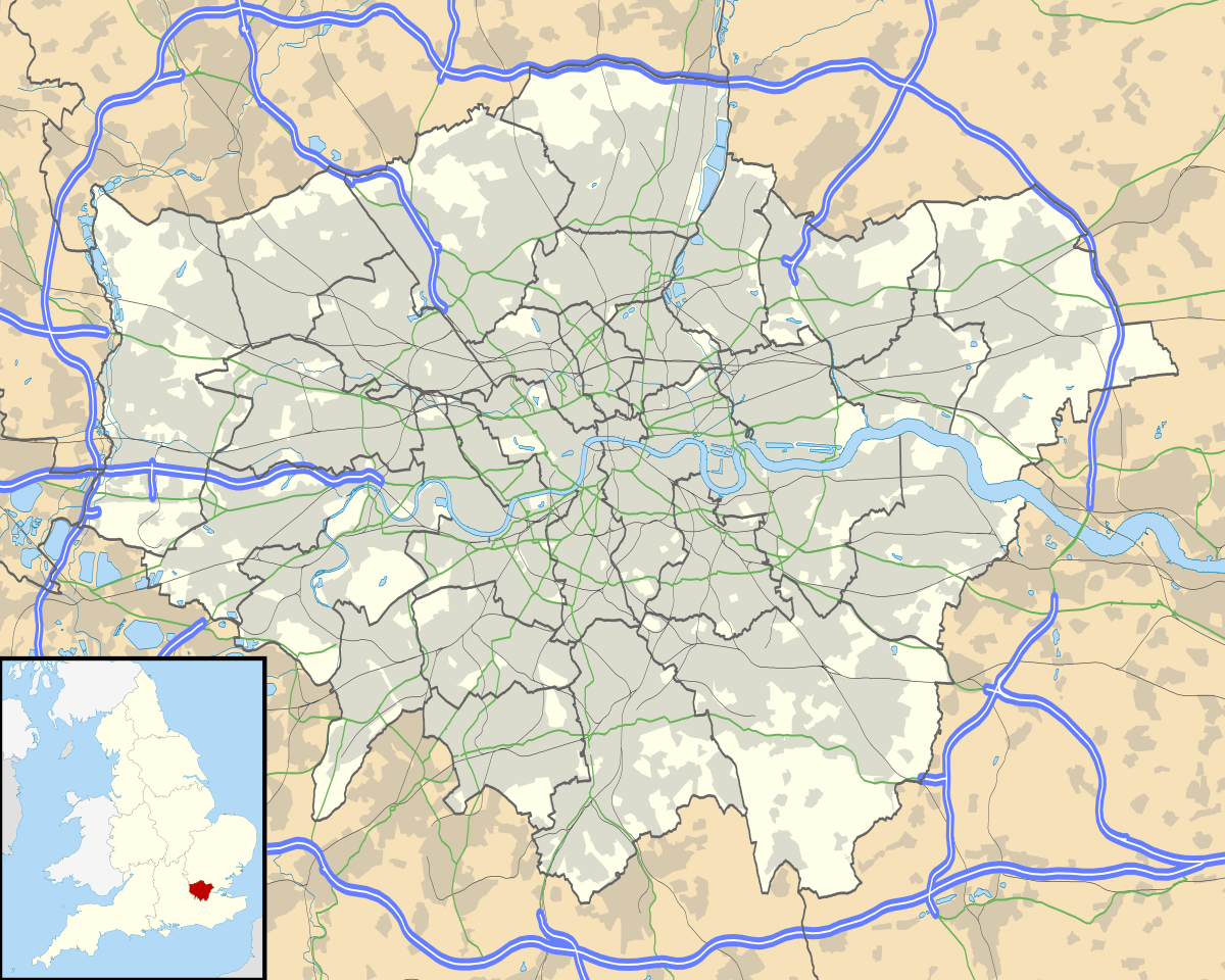 Walthamstow Location within Greater London | |
| Population | 109,424 (2011 Census)[1] |
| OS grid reference | TQ372891 |
| • Charing Cross | 7.5 mi (12.1 km) SW |
| London borough | |
| Ceremonial county | Greater London |
| Region | |
| Country | England |
| Sovereign state | United Kingdom |
| Post town | LONDON |
| Postcode district | E17 |
| Dialling code | 020 |
| Police | Metropolitan |
| Fire | London |
| Ambulance | London |
| UK Parliament | |
| London Assembly | |
History
Toponymy
Walthamstow is recorded c. 1075 as Wilcumestowe ("the Place of Welcome") and in the Domesday Book of 1086 as Wilcumestou.[3]
Early history
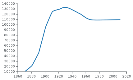
| 1871 | 10,692 |
|---|---|
| 1881 | 21,715 |
| 1891 | 46,346 |
| 1901 | 95,131 |
| 1911 | 124,580 |
| 1921 | 129,395 |
| 1931 | 132,972 |
| 1941 | war # |
| 1951 | 121,135 |
| 1971 | 108,845 |
| 2011 | 109,424 |
| # no census was held due to war | |
| source: UK census[4] | |
The Domesday Book describes Wilcumestou as a manor owned by the Anglo-Saxon nobleman Earl Waltheof of Huntingdon and Northumbria before the Norman conquest of 1066. After the execution of Earl Waltheof, the property of the land passed to his wife, Countess Judith, also known as Judith of Lens, a niece of William the Conqueror. The Domesday Book records 36 villeins, 25 bordars and 4 slaves living in the manor in 1086. Alice, daughter of Earl Waltheof and Countess Judith, inherited Walthamstow. She married the Norman nobleman Ralph de Tosny or Toeni (also known as Raoul IV de Conches) in 1103. When her husband died, c. 1126 , Alice gave the church of Walthamstow to the Priors of the Holy Trinity based in Aldgate, London.
King John stayed in Walthamstow for two nights in February 1208.
Until the 19th century Walthamstow was largely rural, with a small village centre (now Walthamstow Village) and a number of large estates. The main route through the district was Hoe Street. There were various smaller lanes crossing the town. The road now known as Forest Road was originally called Clay Street. Further south, the High Street was named Marsh Street, and led from the original settlement out to the marshes. Shernhall Street is an ancient route, as is Wood Street, to the east.[5]
In the 1660s Sir William Batten, Surveyor of the Navy, and his wife Elizabeth Woodcocke had a house in Wood Street where, according to Samuel Pepys, Batten lived "like a prince"[6] and cultivated a vineyard. The Vestry House, now the Vestry House Museum, was used as the first town hall.
The influential textile designer and craftsman William Morris was born in Walthamstow in 1834. The Georgian mansion where he lived as a teenager houses the William Morris Gallery. By 1870 Walthamstow had grown to the size of a small suburb and a new town hall was built in Orford Road from which affairs of the village were run. A new town hall designed by architect Philip Dalton Hepworth in the Nordic Classical style was built between 1938 and 1942.
Urban development
With the advent of the railways and the ensuing suburbanisation in the late 19th century, Walthamstow experienced a large growth in population and speculative building.[7]

The Lighthouse Methodist Church which dates from 1893 which is situated on Markhouse Road, on the corner of Downsfield Road. There is a lantern at the top of the tower, which also contains a spiral staircase. The church was erected because of the generosity of Captain David King of the shipbuilding firm of Bullard King & Co which also ran the Natal Direct Shipping Line, which ran ships direct from London to Durban without stopping at the Cape.
The LGOC X-type and B-type buses were built at Blackhorse Lane from October 1908 onwards. The B-type is considered one of the first mass-production buses. The manufacturing operation later became AEC, famous as the manufacturer of many of London's buses. On 13 June 1909, A. V. Roe's aircraft took to the air from Walthamstow Marshes. It was the first all-British aircraft[8] and was given the ominous nickname of the "Yellow Terror" but officially carried the name Avro1. Roe later founded the Avro aircraft company, which later built the acclaimed Avro Lancaster.
Local government
From 1894 Walthamstow was an urban district and from 1929 a municipal borough in Essex. In 1931 the population of the borough, covering an area of 4,342 acres (1,757 ha; 6.784 sq mi; 17.57 km2), peaked at 132,972.[9] In 1965 the borough was abolished and its former area merged with that of the Municipal Borough of Chingford and the Municipal Borough of Leyton to form the London Borough of Waltham Forest in Greater London.[9] Other places in east London formerly of the county of Essex, such as Ilford and Romford were placed into London Boroughs along with Walthamstow. None of the postal district names or codes was changed at this time (e.g. Ilford remained Ilford, Essex, and Walthamstow remained London E17).
Recent history
Since the 2012 Summer Olympics, the town has become increasingly popular mostly as a result of gentrification. Local property prices have increased at a high rate of 22.3% from 2013–2014, compared to London's average of 17.8%.[10] It has turned Walthamstow into a 'trendy' town similar to Shoreditch. The leafy Walthamstow Village in particular has become sought-after by buyers.[11]
On 29 May 2015, a regular local unicyclist was hit and dragged under by a double decker route 212 bus in Hoe Street. Locals numbering up to 100 people helped to pull the bus off the unicyclist.[12][13] The MP for Walthamstow, Stella Creasy, later said she was "proud" of the community for saving the unicyclist's life.[14]
Governance
Walthamstow elects councillors to Waltham Forest London Borough Council.
Geography


Walthamstow is bordered to the north by Chingford, south by Leyton and Leytonstone, east by the southern reaches of Epping Forest at Woodford and west by Tottenham and the River Lea valley. The A112 (Leyton High Road, Hoe Street, Chingford Road, Chingford Mount Rd) passes south–north through Walthamstow and its neighbouring towns forming part of an ancient route from London to Waltham Abbey.
Walthamstow Central is the main transport hub.
Walthamstow Village conservation area is a peaceful and attractive district to the east of what has become the commercial centre of Walthamstow. The area is roughly defined as being south of Church Hill, west of Shernhall Street, north of Grove Road, and east of Hoe Street. Orford Road is the main route through the district, though even this is a quiet thoroughfare by the standards of London. The village has a small selection of specialist shops, pubs and restaurants, and house prices tend to be higher in the streets of this neighbourhood. It was voted best urban village in London by Time Out magazine in 2004.
Upper Walthamstow is to the east of Walthamstow Village. The area's main thoroughfare is Wood Street, which has a good selection of shops and local businesses, and is served by the London Overground at Wood Street station on the Liverpool Street to Chingford line.
One of the Great Trees of London, the Wood Street Horse Chestnut, is located next to the former Jones's Butchers Shop, a grade II listed, late 18th century weatherboarded building. The tree is thought to be upwards of 175 years old.
Wood Street is home to Wood Street Indoor Market.[15] The market was the site of a cinema from 1912 to 1955, operated by the Penny Picture Theatre Co. It re-opened under new independent management in 1953 as the Rio Cinema, but this was short lived and it closed in 1955.[16] Now the market is filled with quirky market traders, and was documented in a short documentary made by Mark Windows.[17]
Walthamstow has a wide variety of housing stock, but the vast majority of residential property was built in the early 20th century. From Coppermill Lane in the west (next to the marshes), to Wood Street in the east, there are thousands of terraced streets dating to the Edwardian era and the 1920s. The area along Markhouse Road and St James Street has many examples of Warner properties. These were developed as affordable housing for the working classes in the early part of the 20th century. Bombing raids in the Second World War and urban redevelopment projects in the 1960s and 1970s have left areas with more modern housing, mostly in the shape of low-rise concrete blocks.
The northern continuation of Markhouse Road is St James's Street to which Blackhorse Road follows, served by underground and railway stations, which in turn becomes Blackhorse Lane. This is bound on its western side by industrial units and warehouses. The London Borough of Waltham Forest has proposed developing the area around Blackhorse Road railway station to become a gateway to the town.
Although bounded by the marshes to the west and parts of Epping Forest to the east, there is little open space in the actual town. There used to be two commons in the town, Church Common, adjacent to St. Mary's Church in Walthamstow Village and Markhouse Common, located off Markhouse Lane (now Markhouse Road) and what is now the western end of Queens Road. Both open spaces were lost in the 19th century, when the land was sold to property developers. Lloyd Park has been open to the public since 1900 and is located on Forest Road behind the William Morris Gallery. It has a formal garden with a pond, and the adjacent Aveling Field has facilities for bowling, tennis, basketball, an outdoor gym, a skate park and a children's play area.[18]
Demography
Walthamstow is rather large sized and is made up of seven electoral wards within the London Borough of Waltham Forest: Chapel End (northeastern part), Higham Hill (northwestern part), High Street (western), Hoe Street (inner-eastern and Walthamstow Village), Markhouse (southwestern), William Morris (northern), and Wood Street (eastern and Upper Walthamstow). The 2011 census counted a total population of 109,424 of all these wards combined.[19]
As of the 2011 census, White British is the largest ethnicity in all wards. Other White is the second largest in all wards except Markhouse. The other double-digit ethnicities are Pakistani and Black African. The minority ethnic proportion ranges from 48.5% in Chapel End to 58.2% in Markhouse.[19]
The male life expectancy ranged from 77.2 years in Hoe Street to 82.1 years in Chapel End; the female life expectancy ranged from 82.1 years in both Higham Hill and Hoe Street to 84.8 years in High Street. This data covers 2009-2013.[19]
The median house price as of 2014 was highest in Wood Street ward (£387,500) and lowest in Markhouse ward (£324,000).[19]
| Ward | Detached | Semi-detached | Terraced | Flats and apartments[20][21] |
|---|---|---|---|---|
| Chapel End | 4.9% | 11.9% | 55.0% | 28.3% |
| High Street | 3.0% | 6.9% | 32.1% | 58.0% |
| Higham Hill | 5.4% | 15.9% | 44.3% | 34.3% |
| Hoe Street | 3.2% | 9.7% | 25.1% | 61.9% |
| Markhouse | 6.4% | 10.7% | 46.3% | 36.6% |
| William Morris | 5.0% | 9.3% | 43.0% | 42.6% |
| Wood Street | 3.0% | 12.9% | 30.0% | 54.1% |
Economy
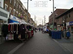
The High Street is dominated by Walthamstow Market, which began in 1885, and occupies all but the last 100 yards of the street. It is reputed to be a mile long, but in fact measures approximately ⅔ of a mile. It is the longest street market in Europe. The market is open five days a week (not Sunday or Monday), and there is a Sunday farmers' market. The street is lined with shops: a selection of high street chains, but also many independent small shops specialising in food, fabrics, and household goods, as well as cafés. The overall tone is downmarket and unique. There are two patches of new-ish development: at Sainsbury's, and The Mall Walthamstow (formerly Selborne Walk) covered shopping centre[22] both of which have large multi-storey car parks. Shopmobility Waltham Forest operates in the Mall, loaning mobility scooters and wheelchairs, with volunteer helpers, to disabled and older people.
The historic central library on the High Street was one of many built with money donated by the Scottish-American businessman and philanthropist Andrew Carnegie, whose portrait bust can be seen on the exterior of the building. The library was damaged by a fire in 1982.[23] It was modernised and expanded in 2006–07, although there were claims that this was at the expense of book holdings. According to the Waltham Forest Guardian, "almost a quarter of a million books have gone missing from Waltham Forest libraries amid claims they have been burned or pulped", and the borough's library stock fell by 60% over the two previous years.[24] At the same time, a large plot at the corner of High Street and Hoe Street was set for substantial redevelopment as a retail space. This site was previously the location of the town's central post office and a shopping arcade built in the 1960s. Plans for the redevelopment of this site initially fell through in 2005, but work on a new cinema, flats and restaurants started in April 2013 and was completed in December 2014.[25] As of 2019, confirmed plans will lead to the refurbishment of the town square, new homes in its vicinity and an extension of The Mall.[26]
Amenities
Walthamstow Borough Corporation had been authorised in 1904 to supply electricity to the Borough. Electricity was supplied from a power station in Exeter Street. The station had three brick chimneys and an array of wooden cooling towers.[27] The generating capacity of Walthamstow power station and the electricity generated over the operational life was as follows.[28][29][30][31]
| Year | Generating capacity, MW | Electricity generated, GWh |
|---|---|---|
| 1913 | – | 5.44 |
| 1923 | 14.1 | 17.72 |
| 1936 | 20.5 | 3.64 |
| 1961 | 19.5 | 2.39 |
| 1964 | 19.5 | 3.41 |
| 1966 | 19.5 | 7.06 |
| 1967 | 19.5 | 7.34 |
In 1923 the revenue to the Borough from sales of electricity was £109,909.[28] Upon nationalisation of the electricity industry in 1948 ownership of the station passed to the British Electricity Authority and later to the Central Electricity Generating Board. The CEGB closed the station in 1967 when the thermal efficiency was 9.30 per cent.[30][32] It was subsequently demolished.
Transport

Rail
Walthamstow is served by trains on the London Underground, London Overground and National Rail networks.
Walthamstow Central is the area's busiest interchange.[33][34] It is the northern terminus of the London Underground Victoria line, which provides the area with a direct connection to Tottenham, the West End and Brixton. The station is also served by London Overground services between London Liverpool Street and Chingford, via Hackney Downs.
There is an out-of-station interchange with Walthamstow Queen's Road, which is on the London Overground between Gospel Oak and Barking.
Blackhorse Road is to the east of Walthamstow, and is also served by Victoria line trains and London Overground trains between Gospel Oak and Barking.
Other stations include St James Street and Wood Street, on the London Overground between Liverpool Street and Chingford.
Lea Bridge is also nearby, served by Greater Anglia trains between Stratford and Bishop's Stortford, via Tottenham Hale and Harlow, with onward connections to London Stansted Airport.
All railway stations are in London fare zone 3, except Wood Street, which is in zone 4.[35]
Buses
London Buses routes 20, 34, 55, 58, 69, 97, 123, 158, 212, 215, 230, 257, 275, 357, 675, W11, W12, W15, W16, W19 and night routes N26, N38 and N73 serve the area.[36][37]
Walthamstow Bus Station is next to Walthamstow Central station, along Selborne Road.
Road
Several arterial routes pass through Walthamstow which link the district to other areas in London and the East of England.
To the north, the A406 (North Circular) runs east–west around Walthamstow. The road links the district to Ilford, the M11 (for Stansted Airport) and London City Airport to the east. To the west, the North Circular passes through Edmonton, Finchley and Brent Cross en route to Chiswick. The route meets the M1 and M4 motorways (for Luton and Heathrow airports).
To the southeast of nearby Leytonstone, the A12 (Eastern Avenue) carries traffic northeast towards the M25, Romford, and destinations in Essex and Suffolk. Southwest, the A12 passes around Stratford and Hackney Wick before terminating in Poplar.
Other routes include:
- A104 (Lea Bridge Road) - southwest to Lea Bridge and Clapton, northeast to the A406 (North Circular), Buckhurst Hill and Epping Forest.
- A112 (Hoe Street/Chingford Road) - southbound to Leyton, Stratford and London City Airport, northbound to the A406 (North Circular), Chingford and Waltham Abbey.
- A1006 - north-south through Walthamstow carried by Church Road, Markhouse Road, St James's Street and Blackhorse Road.
- A503 (Forest Road) - runs east–west through Walthamstow from the A406 (North Circular) in the east to Tottenham, Holloway and Camden Town to the west.
Air pollution
The London Borough of Waltham Forest monitors kerbside and roadside Nitrogen Dioxide (NO2) levels in Walthamstow.
To the north of Walthamstow at the Crooked Billet Roundabout (North Circular), there is an automatic monitoring site which recorded an average NO2 concentration of 61.1μg/m3 (micrograms per cubic metre) in 2017. This fails to meet the UK National Air Quality Objective set by the Department for Environment, Food & Rural Affiars (DEFRA) at 40μg/m3.[38]
Alternative roadside monitoring sites along Hoe Street and Selborne Road also failed to meet the UK National Air Quality Objective, with one diffusion tube on Selborne Road recording an annual average NO2 concentration of 61.0μg/m3.[38]
Cycling
Transport for London (TfL) and the London Borough of Waltham Forest provide cycling infrastructure in Walthamstow. In 2014, cyclists made up approximately 8.41% of general traffic across the Borough, and in the same year, the Borough was awarded a "Mini Holland" grant by the Mayor of London to improve infrastructure and cycle routes across Walthamstow.[39][40]
Cycling routes include:
- Quietway 2 - begins at Walthamstow Central and runs along low-traffic streets to Bloomsbury, via Walthamstow Marshes, Clapton, Hackney Central, Angel and Clerkenwell. The route is unbroken and signposted, but indirect.[41]
- Lea Bridge Road Cycle Route - from Leytonstone to Clapton via Lea Bridge. The route runs on segregated cycle track parallel to the A104.[40]
- Forest Road Cycle Route - from Walthamstow to Tottenham on cycle lanes and tracks adjacent to the A503.[40]
The River Lea towpath is also nearby, which provides a direct, traffic-free cycle link from Walthamstow Marshes to Hackney Wick and Stratford to the south, and Tottenham Hale, Enfield Lock, Hertford and Harlow to the north. The towpath also carries National Cycle Route 1 (NCR 1), an unbroken, signposted cycle route from Dover to the Shetland Islands, which in North London carries cyclists from Canary Wharf to Enfield Lock via Victoria Park and Walthamstow Marshes. The route is a shared-use path maintained by the Canal and River Trust and Sustrans.[42][43]
Modern culture
Walthamstow was home to the popular 1990s boy band East 17, who named themselves after the area's postal code E17, and titled their debut album Walthamstow. The indie rock band The Rifles are from the area as was Jimmy Ray. Ray grew up in the Lloyd Park area and attended Winns primary, and Sidney Chaplin and McEntee secondary schools. In the early 1990s he performed at various E17 venues, including the Royal Standard, as part of local pop group 'The Cutting Room'. Ray later had solo hits in the UK and US. It is home to the band The Bevis Frond.
Walthamstow is a major centre in London's grime music scene, with many bedroom studios and underground music enterprises. Artists include Lethal Bizzle and his band Fire Camp.
The Bromheads Jacket song "Poppy Bird" references Walthamstow in the chorus. Small Wonder Records was located on Hoe Street in the late 70s/ early 80s. It produced the first records by The Cure, Crass, Cockney Rejects, The Cravats and Bauhaus as well as being a huge draw for punk and new wave fans. The proprietor Pete Stenett closed the shop and label in 1982, but it was 'rebuilt' further down Hoe Street for the 40th anniversary of E17 punk in 2016. Walthamstow is mentioned in the Paul McCartney and Wings song "Old Siam, Sir" from the 1979 album Back to the Egg.
"Long ago, outside a chip shop in Walthamstow" is the first line of a song named "Ann and Joe", recorded by The Barron Knights in the late 1970s. This was a spoof of "Long ago, high on a mountain in Mexico", the opening words of Angelo, which was a UK number one hit in 1977 for Brotherhood of Man.
"Waiting in Walthamstow" is a song by The Cranberries from the album Roses.
The track the "Battle of Epping Forest" by Genesis on the album Selling England by the Pound has lyrics based in the area such as "Along the Forest Road, there's hundreds of cars - luxury cars."
The artwork for Blur's Parklife album featured photos of the band at Walthamstow Stadium.[44]

Cinema
An early British film studio the Walthamstow Studios operated in the area between 1914 and 1930.
The EMD (Granada) Walthamstow, a landmark Grade II listed cinema building (formerly the Granada)[45] with connections to Alfred Hitchcock in Hoe Street closed in 2003 when it was sold to the Universal Church of the Kingdom of God (UCKG) which sought permission for a change of use to a place of worship.
Many members of the local community opposed and successfully campaigned against the UCKG plans. Comedian and presenter Griff Rhys Jones, actor Paul McGann and writer Alain de Botton are among the famous names to have backed local residents in asking the local authority to stop plans to convert the building into a church.
The Waltham Forest Film Society and Campaign to save our cinema McGuffin, was the focal point for local campaigners.
UCKG failed to gain planning permission to convert the building from Waltham Forest Council and later from the then Secretary of State for Communities and Local Government, Eric Pickles. In 2014 the building was sold to a pub company[46] who set up a bar in the grand foyer and began bringing it back into use as a venue. In 2019 Waltham Forest Council purchased the former auditorium with the intention of opening it as an entertainment venue in 2022.[47]
The Empire cinema[48] a separate new multiplex opened in December 2014 on Walthamstow market.
Sports clubs
- Walthamstow F.C.
- Walthamstow Avenue F.C. (defunct club located at Green Pond Road Stadium)
- Walthamstow Avenue & Pennant
- Haringey & Waltham Development F.C.
- Walthamstow Cricket Club[49]
Education
Walthamstow secondary schools include:
- Frederick Bremer School
- Forest School
- Holy Family Catholic School
- Kelmscott School
- Walthamstow Academy
- Walthamstow School for Girls
- Willowfield School
Sixth form and further education providers include:
Notable residents
One of its most famous residents was the writer, poet, designer and socialist William Morris, who was born there on 24 March 1834, and lived there for several years. His former house in Walthamstow is a museum dedicated to his life and works, while the grounds of the house are a public park (Lloyd Park in Forest Road).
- Naomi Ackie, actress, attended Walthamstow School for Girls.
- Keith Albarn, manager of Soft Machine and father of Damon Albarn, taught art at Walthamstow Art College in the 1960s
- Sonita Alleyne, Master of Jesus College, Cambridge
- Clement Attlee, Member of Parliament for Walthamstow while he was Prime Minister.
- Sir William Batten (died 1667), Surveyor of the Navy, had a "palatial" country house at Walthamstow; his son, who was in debt, sold it off a few years after his death.
- Stephen Bear reality TV star
- Alonza Bevan, bass guitarist of Kula Shaker.
- Lethal Bizzle, Rap/Grime artist[50] and associated rap collective Fire Camp, Attended Holy Family Catholic School.
- Denis Blackham, renowned music mastering engineer.
- Peter Blake, artist, painted sleeve cover of the Beatles Sgt. Peppers Lonely Hearts Club Band.
- Leonard Borwick, concert pianist, born in 1868.
- Matthew Bourne OBE, choreographer and dancer, was born in Walthamstow.
- Mick Box, guitarist for Uriah Heep, born in Walthamstow.
- Theodore Ronald Brailey, pianist on the RMS Titanic
- Frederick Bremer, engineer and inventor, built the first petrol-driven car in Great Britain between 1892 and 1894 (now on display in the Vestry House Museum)
- David Cairns, guitarist with Secret Affair, was born in Walthamstow in 1958.
- Alexander Champion, founder of British whaling, died 1795 in Walthamstow
- Anjem Choudary, radical Islamist preacher
- Phil Collen, lead guitarist of Def Leppard
- Stella Creasy, Labour MP
- Iain Dale, broadcaster
- Sir John Dankworth, jazz musician, who attended Sir George Monoux Grammar School.
- Paul Di'Anno, lead singer of Iron Maiden 1978–81.
- Adam Devlin, guitarist for the Bluetones, lives in Walthamstow.
- Benjamin Disraeli, former British Prime Minister, attended Higham Hill School in Walthamstow, as did William Shore, later father of Florence Nightingale
- Ian Dury, singer and songwriter, studied at Walthamstow Art College.
- Fleur East, singer and The X Factor finalist (runners-up), attended Holy Family Catholic school
- East 17, British pop boy band, including singer/songwriter Brian Harvey.
- Sir George Edwards, designer of Concorde
- Joe Ellis-Grewal, cricketer
- Lucian Ercolani, founder of furniture company Ercol, was living at 27 Claremont Road, Walthamstow in the 1911 census
- Jody Fleisch, English professional wrestler, debuted in 1996, and is still wrestling around the world
- Air Marshal Sir Kenneth Charles Michael Giddings CB OBE DFC AFC*, born in Walthamstow in 1920
- Thomas Field Gibson, manufacturer who aided the welfare of the Spitalfields silk weavers, lived at Clay Hill
- Maurice Glasman, social theorist and Labour life peer
- Eleanor Graham, book editor and children's book author, born in Walthamstow
- Peter Greenaway, film director, studied at Walthamstow College of Art
- Daisy Greville, Countess of Warwick, heir to the Maynard estate and Shern Hall in particular at which she lived briefly after her father's death[51]
- Fitz Hall, English footballer currently playing for Watford was born in Walthamstow
- Darren Hayman, singer and songwriter, former resident
- Lord Peter Hennessy of Nympsfield, former journalist with The Times; historian, academic and author
- James Hilton, author, attended George Monoux Grammar School
- Helen Hollick, writer, born in Walthamstow 1953
- Mick Hume, journalist
- Countess Judith, wife of Earl Waltheof, prominent post-Conquest woman
- Harry Kane, footballer, attended Chingford Foundation School
- Colin Kazim-Richards, footballer, was born in Leytonstone but schooled in Walthamstow
- Agnes Marshall, English culinary entrepreneur, born in Walthamstow in 1855
- Sir George Monoux, Lord Mayor of London in 1514 and local benefactor; founded the grammar school and almshouses
- William Morris, designer, socialist and artist
- Fabrice Muamba, footballer, attended Kelmscott School
- Lutalo Muhammad, British taekwondo athlete, won a silver medal in the 2016 Olympics, attended Holy Family Catholic School
- Denis Payton, saxophonist for the Dave Clark Five, was born in Walthamstow 1943
- Grayson Perry, ceramicist and 2003 Turner Prize winner, had his studio in Walthamstow until 2014. He referred to Walthamstow in his 2013 Reith lectures, naming it 'Awesomestow'
- Pascale Petit, poet, nominated twice for the TS Eliot poetry prize
- Fred Pontin, holiday camp owner
- Jimmy Ray, recording artist, born Walthamstow 1970
- Ken Russell, film director, studied at Walthamstow Technical College
- Nick Saloman, progressive rock musician
- June Sarpong, television presenter, born Walthamstow 1977
- Baroness Scotland, Attorney General, grew up in Walthamstow and attended Walthamstow School for Girls
- Vivian Stanshall, musician, painter, singer, broadcaster, songwriter, poet and writer, best known for his work with the Bonzo Dog Doo-Dah Band, grew up in Grove Road, Walthamstow.
- John Kemp Starley, inventor, born Walthamstow 1854
- Colin Stinton, Canadian-born actor
- Thomas Griffith Taylor (1890–1963) Antarctic explorer
- Lawrence Trent, international chess master and commentator
- Nicola Walker, actor, attended Forest School
- Peter Waterfield Olympic diver
- Dorothy Wedderburn Principal of Bedford College and Royal Holloway and Bedford New College, both London University, was born in Walthamstow 1925
- Geoffrey Wellum, RAF fighter pilot in the Battle of Britain was born Walthamstow in 1921
- Danniella Westbrook, actress
- Sir Robert Wigram, shipbuilder and MP
- Timothy Williams, bilingual novelist of crime fiction, lived at Whipps Cross
- Peter Winch, philosopher
- Adam Woodyatt, English actor who plays Ian Beale in EastEnders, born in Walthamstow 1968
Gallery
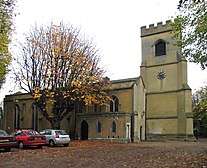 St Mary's Parish Church dates from the 12th century
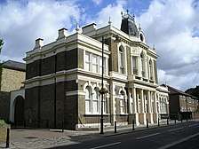 Walthamstow Old Town Hall, now Yiguandao UK headquarters
 15th century "Ancient House" in Walthamstow village
 Monoux Almshouses in the village
 Vestry House Museum
 William Morris Gallery
 Longitude zero marker in Upper Walthamstow Road
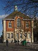 Walthamstow Central Library
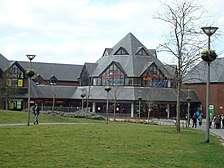 Selborne Walk Shopping Centre, now called The Mall Walthamstow
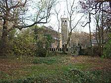 St Peter's-in-the-Forest church, near Woodford New Road in the southern edge of Epping Forest
 Walthamstow Reservoir
 Walthamstow Marshes
 Front of the bus and train station interchange
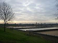 The filter beds at Coppermills Treatment Works
References
- Walthamstow is made up of 7 wards in the London Borough of Waltham Forest: Chapel End, Higham Hill, High Street, Hoe Street, Markhouse, William Morris, and Wood Street. "Archived copy". Archived from the original on 22 Feb 2014. Retrieved 9 Jun 2014.CS1 maint: archived copy as title (link)
- Mayor of London (Feb 2008). "London Plan (Consolidated with Alterations since 2004)" (PDF). Greater London Authority.
- Mills, A., Oxford Dictionary of London Place Names, Oxford University Press, ISBN 978-0-19-956678-5, (2001)
- "Walthamstow CP/AP through time | Population Statistics | Total Population". Visionofbritain.org.uk. Retrieved 1 Aug 2015.
- "Walthamstow -- Introduction and domestic buildings". University of London & History of Parliament Trust. Retrieved 30 Jun 2013.
- http://www.histparl.ac.uk/volume/1660-1690/member/batten-sir-william-1601-67
- Walthamstow: Introduction and domestic buildings, A History of the County of Essex: Volume 6 (1973), pp. 240–50. Date accessed: 1 April 2007.
- https://www.guardian-series.co.uk/news/4471811.walthamstow-historic-celebration-of-av-roe-flight-next-sunday/
- "History of Walthamstow, Essex". University of Portsmouth. Retrieved 21 Jun 2013.
- "Subscribe to read". Financial Times.
- Jones, Rupert (16 Dec 2015). "Gentrification fears loom over rise in east London 'property millionaires'" – via The Guardian.
- Elgot, Jessica; agencies (29 May 2015). "Londoners drag doubledecker bus off injured unicyclist" – via The Guardian.
- Heyden, Tom (4 Jun 2015). "When 100 people lift a bus" – via www.bbc.co.uk.
- "Stella Creasy: 'I'm proud of how my community lifted a bus to save". 8 Jun 2015.
- "Wood Street Indoor Market | Wood Street Indoor Market, Walthamstow, E17 Website". Woodstreetmarket.com. Retrieved 1 Aug 2015.
- "Crown Cinema". Retrieved 30 Jun 2013.
- "the collectors of wood street". YouTube. 19 Jul 2006. Retrieved 1 Aug 2015.
- "Lloyd Park". Walthamforest.gov.uk. London Borough of Waltham Forest. Retrieved 6 Feb 2015.
- https://data.london.gov.uk/dataset/ward-profiles-and-atlas
- "Neighbourhood statistics". Office for National Statistics.
- Census Information Scheme (2012). "2011 Census Ward Population Estimates". Greater London Authority. Retrieved 30 Jan 2013.
- "Shopping Centres in the UK - The Mall Shopping Centres". Themall.co.uk. Retrieved 1 Aug 2015.
- https://www.guardian-series.co.uk/news/4486372.walthamstow-library-celebrates-100-years/
- WALTHAM FOREST: Were 250,000 library books burned?, Sarah Cosgrove, Waltham Forest Guardian, 22 November 2007
- "Walthamstow arcade site". London Borough of Waltham Forest. Retrieved 30 Jun 2013.
- https://walthamforestecho.co.uk/new-tube-station-entrance-planned-at-the-mall/
- "Exeter Road power station". Facebook. 1950s. Retrieved 3 Feb 2020.
- London County Council (1926). London statistics 1924-5 vol. 30. London: London County Council. pp. 298–305.
- London County Council (1934). London Statistics 1932-3. London: London County Council. pp. 330–49.
- CEGB Statistical Yearbook (1964-67). CEGB, London.
- "British Power Stations operating at 31 December 1961". Electrical Review. 1 June 1962: 931. 1962.
- CEGB Statistical Yearbook 1964-67. CEGB, London.
- "Multi-year station entry-and exit figures". Transport for London. Archived from the original on 24 Apr 2019.
- "Estimates of station usage". Office of Rail and Road. Archived from the original on 7 May 2019.
- "London's Rail & Tube services" (PDF). Transport for London. Archived from the original (PDF) on 29 Apr 2019.
- "Buses from Walthamstow Central" (PDF). Transport for London. Retrieved 16 Oct 2019.
- "Night buses from Walthamstow Central" (PDF). Transport for London. Retrieved 16 Oct 2019.
- "Detailed Modelling of Nitrogen Dioxide in the London Borough of Waltham Forest" (PDF). London Borough of Waltham Forest. Archived from the original (PDF) on 10 May 2019.
- "2020 Vision: Cycling in the London Borough of Waltham Forest 2015-2020" (PDF). London Borough of Waltham Forest. Archived from the original (PDF) on 17 May 2017.
- "Enjoy Waltham Forest: Walking and Cycling Account 2017/18" (PDF). London Borough of Waltham Forest. Archived from the original (PDF) on 10 May 2019.
- "Quietway 2 (East): Bloomsbury to Walthamstow" (PDF). Transport for London. Archived from the original (PDF) on 7 Apr 2019.
- "Route 1". Sustrans. Retrieved 10 May 2019.
- "Cycling". Canal & River Trust. Archived from the original on 7 Apr 2019.
- https://www.nme.com/news/music/blur-319-1323933
- "Granada Cinema, Walthamstow, in 1989". Retrieved 21 Jun 2013.
- "Hitchcock's Cinema Is Back From The Dead As A Pub". Londonist. 14 Dec 2015. Retrieved 10 Oct 2017.
- https://www.timeout.com/london/news/this-abandoned-walthamstow-cinema-is-being-brought-back-to-spectacular-life-052119
- "EMPIRE CINEMAS Listings for Walthamstow". Empirecinemas.co.uk. Retrieved 1 Aug 2015.
- "Walthamstow Cricket Club : home". Walthamstowcc.hitscricket.com. 3 Jun 2015. Retrieved 1 Aug 2015.
- "Comment: editorials, opinion and columns". Telegraph. Retrieved 1 Aug 2015.
- Sushila, Anand (2009). Daisy : the life and loves of the Countess of Warwick (Paperback ed.). Piatkus Books. ISBN 9780749909772. OCLC 276816379.
External links
| Wikimedia Commons has media related to Walthamstow. |
- British History Online - A History of the County of Essex: Volume 6
- Richard Dunn - A brief history of Walthamstow
- Walthamstow Memories - Recollections of past and present Walthamstow residents.
- Archival Material relating to Walthamstow listed at the UK National Register of Archives
- Portraits of Valentine La Touche McEntee, 1st Baron McEntee of Walthamstow at the National Portrait Gallery, London
- Images of Walthamstow at the English Heritage Archive
- Nostalgic photos of Walthamstow at History-in-Pictures.co.uk
| Districts |
|  |
|---|---|---|
| Attractions |
| |
| Street markets | ||
| Parks and open spaces |
| |
| Constituencies |
| |
| Tube and rail stations | ||
| Other topics | ||
| ||
| Authority control |
|
|---|