River Lea
The River Lea, also spelt Lee, is a river in South East England. It originates in the Bedfordshire part of the Chiltern Hills, and flows southeast through Hertfordshire and then Greater London, sometimes through several channels, to ultimately meet the River Thames, the last looping section being known as Bow Creek. It is one of the largest rivers in London and the easternmost major tributary of the Thames. Its valley creates a long chain of marshy ground along its lower length, much of which has been used for gravel and mineral extraction, reservoirs and industry. Below Hertford the river has since medieval times had alterations made to make it gradually navigable for boats between the Thames and eastern Hertfordshire and Essex, known as the Lee Navigation. This stimulated much industry along its banks. The navigable River Stort, a main tributary, joins it at Hoddesdon.
| Lea Lee | |
|---|---|
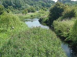
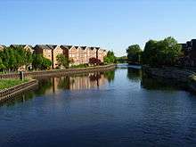
 River Lea at Hertford Basin | |
| Location | |
| Country | United Kingdom |
| Physical characteristics | |
| Source | |
| ⁃ location | Leagrave, Luton |
| ⁃ coordinates | 51.910338°N 0.461233°W |
| ⁃ elevation | 115 m (377 ft) |
| Mouth | |
⁃ location | Bow Creek, River Thames |
⁃ coordinates | 51.5072°N 0.0092°E |
⁃ elevation | 0 m (0 ft) |
| Length | 68 km (42 mi) |
| Discharge | |
| ⁃ location | Luton Hoo, Luton |
| ⁃ average | 1.8 m3/s (64 cu ft/s) |
| Discharge | |
| ⁃ location | Feildes Weir Nr. Hoddesdon |
| ⁃ average | 4.3 m3/s (150 cu ft/s) |
| Basin features | |
| Designation | |
| Official name | Lee Valley |
| Designated | 9 October 2000 |
| Reference no. | 1037[1] |
| Upper River Lea/Lee | |||||||||||||||||||||||||||||||||||||||||||||||||||||||||||||||||||||||||||||||||||||||||||||||||||||||||||||||||||||||||||||||||||||||||||||||||||||||||||||||||||||||||||||||||||||||||||||||||||||||||||||||||||||||||||||||||||||||||||||||||||||||||||||||||||||||||||||||||||||||||||||||||||||||||||||||||||||||||||||||||||||||||||||||||||||||||||||||||||||||||||||||||||||||||||||||||||||||||||||||||||||||||||||||||||||||||||||||||||||||||||||||||||||||||||||||||||||||||||||||||||||||||||||||||||||||||||||||||||||||||||||||||||||||||||||||||||||||||||||||||||||||||||||||||||||||||||||||||||||||||||||||||||||||||||||||||||||||||||||||||||||||||
|---|---|---|---|---|---|---|---|---|---|---|---|---|---|---|---|---|---|---|---|---|---|---|---|---|---|---|---|---|---|---|---|---|---|---|---|---|---|---|---|---|---|---|---|---|---|---|---|---|---|---|---|---|---|---|---|---|---|---|---|---|---|---|---|---|---|---|---|---|---|---|---|---|---|---|---|---|---|---|---|---|---|---|---|---|---|---|---|---|---|---|---|---|---|---|---|---|---|---|---|---|---|---|---|---|---|---|---|---|---|---|---|---|---|---|---|---|---|---|---|---|---|---|---|---|---|---|---|---|---|---|---|---|---|---|---|---|---|---|---|---|---|---|---|---|---|---|---|---|---|---|---|---|---|---|---|---|---|---|---|---|---|---|---|---|---|---|---|---|---|---|---|---|---|---|---|---|---|---|---|---|---|---|---|---|---|---|---|---|---|---|---|---|---|---|---|---|---|---|---|---|---|---|---|---|---|---|---|---|---|---|---|---|---|---|---|---|---|---|---|---|---|---|---|---|---|---|---|---|---|---|---|---|---|---|---|---|---|---|---|---|---|---|---|---|---|---|---|---|---|---|---|---|---|---|---|---|---|---|---|---|---|---|---|---|---|---|---|---|---|---|---|---|---|---|---|---|---|---|---|---|---|---|---|---|---|---|---|---|---|---|---|---|---|---|---|---|---|---|---|---|---|---|---|---|---|---|---|---|---|---|---|---|---|---|---|---|---|---|---|---|---|---|---|---|---|---|---|---|---|---|---|---|---|---|---|---|---|---|---|---|---|---|---|---|---|---|---|---|---|---|---|---|---|---|---|---|---|---|---|---|---|---|---|---|---|---|---|---|---|---|---|---|---|---|---|---|---|---|---|---|---|---|---|---|---|---|---|---|---|---|---|---|---|---|---|---|---|---|---|---|---|---|---|---|---|---|---|---|---|---|---|---|---|---|---|---|---|---|---|---|---|---|---|---|---|---|---|---|---|---|---|---|---|---|---|---|---|---|---|---|---|---|---|---|---|---|---|---|---|---|---|---|---|---|---|---|---|---|---|---|---|---|---|---|---|---|---|---|---|---|---|---|---|---|---|---|---|---|---|---|---|---|---|---|---|---|---|---|---|---|---|---|---|---|---|---|---|---|---|---|---|---|---|---|---|---|---|---|---|---|---|---|---|---|---|---|---|---|---|---|---|---|---|---|---|---|---|---|---|---|---|---|---|---|---|---|---|---|---|---|---|---|---|---|---|---|---|---|---|---|---|---|---|---|---|---|---|---|---|---|---|---|---|---|---|---|---|---|---|---|---|---|---|---|---|---|---|---|---|---|---|---|---|---|---|---|---|---|---|---|---|---|---|---|---|---|---|---|---|---|---|---|---|---|---|---|---|---|---|---|---|---|---|---|---|---|---|---|---|---|---|---|---|---|---|---|---|---|---|---|---|---|---|---|---|---|---|---|---|---|---|---|---|---|---|---|---|---|---|
| |||||||||||||||||||||||||||||||||||||||||||||||||||||||||||||||||||||||||||||||||||||||||||||||||||||||||||||||||||||||||||||||||||||||||||||||||||||||||||||||||||||||||||||||||||||||||||||||||||||||||||||||||||||||||||||||||||||||||||||||||||||||||||||||||||||||||||||||||||||||||||||||||||||||||||||||||||||||||||||||||||||||||||||||||||||||||||||||||||||||||||||||||||||||||||||||||||||||||||||||||||||||||||||||||||||||||||||||||||||||||||||||||||||||||||||||||||||||||||||||||||||||||||||||||||||||||||||||||||||||||||||||||||||||||||||||||||||||||||||||||||||||||||||||||||||||||||||||||||||||||||||||||||||||||||||||||||||||||||||||||||||||||
While the lower Lea remains somewhat polluted, its upper stretch and tributaries, classified as chalk streams, are a major source of drinking water for London. An artificial waterway known as the New River, opened in 1613, abstracts clean water away from the upper stretch of the river near Hertford for drinking, [2] and lower parts of the river are also abstracted from. The Lea's origins in the Chilterns contribute to the extreme hardness (high mineral content) of London tap water.[3]
Etymology
The name of the River Lea was first recorded in the 9th century, although is believed to be much older. Spellings from the Anglo-Saxon period include Lig(e)an in 880 and Lygan in 895, and in the early medieval period it is usually Luye or Leye. It seems to be derived from a Celtic (brythonic) root lug-meaning 'bright or light' which is also the derivation of a name for a deity, so the meaning may be 'bright river' or 'river dedicated to the god Lugus'.[4][5] A simpler derivation may well be the Brythonic word cognate with the modern Welsh "Li" pronounced "Lea" which means a flow or a current.
The spelling Lea predominates west (upstream) of Hertford, but both spellings (Lea and Lee) are used from Hertford to the River Thames. The Lee Navigation was established by Acts of Parliament and only that spelling is used in this context. The Lee Valley Regional Park Authority also uses this spelling for leisure facilities. However, the spelling Lea is used for road names, locations and other infrastructure in the capital, such as Leamouth, Lea Bridge, the Lea Valley Walk and the Lea Valley Railway Lines. This spelling is also used in geology, archaeology, etc. to refer to the Lea Valley. The divergent spellings of the river are also reflected in place-names, including Leagrave, the suburb of Luton where the source of the river is located, and of Luton and Leyton: both mean "farmstead on the River Lea".[6]
Course

The source is usually said to be at Well Head inside Waulud's Bank at Leagrave, but there the River Lea is also fed by Houghton Brook, a stream that starts 2 miles (3.2 km) further west in Houghton Regis. The river flows through (or by) Luton, Harpenden, Wheathampstead, Welwyn Garden City, to Hertford where it changes from a small shallow river to a deep canal at Hertford Castle Weir, which then flows on to Ware, Stanstead Abbotts, Hoddesdon, Broxbourne, Cheshunt, Waltham Abbey, Enfield Lock, Ponders End, Edmonton, Chingford, Tottenham, Walthamstow, Upper Clapton, Leyton, Hackney Wick, Stratford, Bromley-by-Bow (past Fish Island), Poplar, Canning Town and finally Leamouth where (as Bow Creek) it meets the River Thames. It forms the traditional boundary between the counties of Middlesex and Essex, and was used for part of the Danelaw boundary. It also forms part of the boundary between Essex and Hertfordshire.
The River Stort is an important tributary of the Lea. It is itself navigable until Bishop's Stortford. It joins the Lea at Feildes Weir, Hoddesdon where boats may access it from the main river via a lock.

For much of its distance the river runs within or as a boundary to the Lee Valley Park. Between Tottenham and Hackney the Lea feeds Tottenham Marshes, Walthamstow Marshes and Hackney Marshes (the latter now drained). In their early days, Tottenham Hotspur and Leyton Orient played their matches as football amateurs on the Marshes. South of Hackney Wick the river's course is split, running almost completely in man made channels (originally created to power water mills, the Bow Back Rivers) flowing through an area that was once a thriving industrial zone.
Inside Greater London below Enfield Lock the river forms the boundary with the former Royal Small Arms Factory, now known as Enfield Island Village, a housing development. Just downstream the river is joined by the River Lee Flood Relief Channel. The man-made, concrete-banked watercourse is known as the River Lee Diversion at this point as it passes to the east of a pair of reservoirs: the King George V Reservoir at Ponders End/Chingford and William Girling Reservoir at Edmonton known collectively as the Chingford Reservoirs; and to the west of the Banbury Reservoir at Walthamstow. At Tottenham Hale there is a connected set of reservoirs; Lockwood Reservoir, High Maynard Reservoir, Low Maynard Reservoir, Walthamstow Reservoirs, East Warwick Reservoir and West Warwick Reservoir. It also passes the Three Mills, a restored tidal mill near Bow.
River history
In the Roman era, Old Ford, as the name suggests, was the ancient, most downstream, crossing point of the River Lea. This was part of a pre-Roman route that followed the modern Oxford Street, Old Street, through Bethnal Green to Old Ford and thence across a causeway through the marshes, known as Wanstead Slip (now in Leyton). The route then continued through Essex to Colchester. At this time, the Lea was a wider river, and the tidal estuary stretched as far as Hackney Wick.[7] Evidence of a late Roman settlement at Old Ford, dating from the 4th and 5th centuries, has been found.
Somewhere between 878 and 890 the Treaty of Alfred and Guthrum was drawn up that amongst other things used the course of the Lea to define the border between the Danes and the English. In 894, a force of Danes sailed up the river to Hertford,[8] and in about 895 they built a fortified camp, in the higher reaches of the Lea, about 20 miles (32.2 km) north of London. Alfred the Great saw an opportunity to defeat the Danes and dug a new channel to lower the level of the river, leaving the Dane's stranded.[9]
In 1110, Matilda, wife of Henry I, reputedly took a tumble at the ford, on her way to Barking Abbey and ordered a distinctively bow-shaped, three-arched, bridge to be built over the River Lea (The like of which had not been seen before), at Bow. During the Middle Ages, Temple Mills, Abbey Mills, Old Ford and Bow were the sites of water mills (mainly in ecclesiastic ownership) that supplied flour to the bakers of Stratforde-atte-Bow, and hence bread to the City. It was the channels created for these mills that caused the Bow Back Rivers to be cut through the former Roman stone causeway at Stratford (from which the name is derived).
Improvements were made to the river from 1424, with tolls being levied to compensate the landowners, and in 1571, there were riots after the extension of the River was promoted in a private bill presented to the House of Commons. By 1577, the first lock was established at Waltham Abbey and the river began to be actively managed for navigation.[10]
The New River was constructed in 1613 to take clean water to London, from the Lea and its catchment areas in Hertfordshire and bypass the polluting industries that had developed in the Lea's downstream reaches.[11] The artificial channel further reduced the flow to the natural river and by 1767 locks were installed below Hertford Castle Weir on the canalised part of the Lea, now the Lee Navigation with further locks and canalisation taking place during the succeeding centuries. In 1766, work also began on the Limehouse Cut to connect the river, at Bromley-by-Bow, with the Thames at Limehouse Basin.[11]
The River Lea flows through the old brewing and malting centre of Ware, and consequently transport by water was for many years a significant industry based there. Barley was transported into Ware, and malt out via the river, in particular to London. Bargemen born in Ware were given the "freedom of the River Thames" — avoiding the requirement of paying lock dues — as a result of their transport of fresh water and food to London during The Great Plague of 1665–66. A local legend says that dead bodies were brought out of London at that time via the river for burying in Ware, but there is no evidence for this.[12]
The Waterworks River, a part of the tidal Bow Back Rivers, has been widened by 8 metres (26 ft) and canalised to assist with construction of the Olympic Park for the 2012 Summer Olympics. In 2009, Three Mills Lock was installed on the Prescott Channel to maintain water levels on the Lea, within the park at a depth of 2 metres (7 ft). This allowed access by 350–tonnes barges to ensure that at least 50% of the material required for construction could be delivered, or removed, by water. (These figures are under review. It is stipulated that the governing body has re appraised these figures).[13]
Wildlife
The river contains fish and other wildlife such as the occasional seal but these are threatened by pollution such as runoff.[14][15]
Some boat trippers reported observing on 5 August 2005 a Canada goose being pulled underwater very quickly. The London Wildlife Trust suggested that this was most likely caused by a pike.[16]
In 2011, Mike Wells claimed that he saw a "goose go vertically down" in the river. Again a pike or mink was suggested as most likely.[17] Vice Magazine suggested that Wells' story may have been invented to publicise authorities' attempts to evict houseboats from the area that year, in advance of the 2012 Olympic Games.[18]
Narrative accounts
The poem A Tale of Two Swannes is set along the River Lee. It was written by William Vallans and published in 1590.[19]
The old course of the river is the one featured in the early chapters of the classic fishing book The Compleat Angler by Izaak Walton. The author begins at Tottenham and proceeds upriver from there.
A guide to walking along the river valley was written by Leigh Hatts,[20] and an account of a walk along the complete length of the river in 2009 was published as a blog by "Diamond Geezer".[21]
In 2014, German writer Esther Kinsky published a novel, Am Fluß, now available in English as River, translated by Iain Galbraith[22] based around her walks along the River Lea beginning at Horseshoe Point and ending at the river's mouth where it joins the Thames.
Notable fisheries
See also
- Bow Back Rivers
- Lea Valley
- Lea Valley Walk
- List of rivers in England
- List of reservoirs and dams in the United Kingdom
- Locks and Weirs on the River Lea
- Lower Lea Valley
- Lee Navigation
- Tributaries of the River Thames
- Lea Valley Lines
- Walthamstow Pump House Museum
Tributaries
- For a full list of tributaries, please expand the box entitled 'River Lea / Lee, England' at the bottom of this page.
References
| Wikimedia Commons has media related to River Lea. |
- "Lee Valley". Ramsar Sites Information Service. Retrieved 25 April 2018.
- <https://corporate.thameswater.co.uk/media/News-releases/News-Release---New-River-feature>
- "EC1A 7BE — Water quality in your area". Thames Water. Archived from the original on 27 May 2012. Retrieved 3 March 2012.
- J.E.B. Glover, Allen Mawer, F.M.Stenton (1938). The Place-Names of Hertfordshire. English Place-Name Society, vol. XV. Cambridge University Press.CS1 maint: multiple names: authors list (link)
- Anthony David Mills (2001). Oxford Dictionary of London Place Names. Oxford University Press. p. 133. ISBN 0-19-280106-6.
- Mills, A.D. (1991). The Popular Dictionary of English Place-Names. Oxford: Phaidon.
- Stepney, Bethnal Green (1998). "Bethnal Green: Communications". A History of the County of Middlesex. 11: 88–90. Retrieved 15 November 2006.
- Hadfield, Charles (1968). The Canal Age. Plymouth: Latimer Trend & Company. pp. 15, 19. ISBN 0-7153-8079-6.
- Blog by the author of a book about Alfred, quoting the Anglo-Saxon Chronicle https://king-alfred.com/wp/2019/10/16/river-lea/
- "William Vallans: A Tale of Two Swannes". spenserians.cath.vt.edu. Retrieved 17 July 2016.
- Enfield.gov.uk River Lee History
- "Ware – The Story so Far – 3 of 3". Ware Online. Archived from the original on 25 February 2009. Retrieved 2 March 2010.
- Milestone 5 Archived 12 May 2008 at the Wayback Machine demolish, dig, design January 2008 (The Olympic Delivery Authority) accessed 25 April 2008
- Gelder, Sam. "Investigation launched after 'hundreds' of dead fish spotted in River Lea by Clapton boaters". Hackney Gazette. Retrieved 29 August 2019.
- "Moment playful seal is spotted catching fish in London's River Lea". Evening Standard. 9 April 2019. Retrieved 29 August 2019.
- "Boat trip fuels 'river croc' tale". BBC. 5 August 2005. Retrieved 27 December 2011.
- "Goose-killer lurks in River Lea". BBC. 13 December 2011. Retrieved 27 December 2011.
- Haddow, Joshua (29 May 2012). "Hunting for the Olympics River Monster". Vice. Retrieved 9 September 2019.
- English Poetry 1579–1830, William Vallans:A Tale of Two Swannes.
- L. Hatts, The Lea Valley Walk, Cicerone Press, 2nd edition, 2007, ISBN 978-1-85284-522-3.
- Diamond Geezer, Walking the Lea Valley, with more photos on flickr.
- River, translated by Iain Galbraith and published by Fitzcarraldo Editions. ISBN 978-1-91069-529-6
External links
- Peter Marshall, The Lea Valley, photographs from 1980 to 2008
- UK Urban Exploration Forums, River Lea through Luton, photographs of the underground culvert in March 2009
- "Wikipaddle: River Lea (Hertford Loop)". Archived from the original on 28 July 2011. Retrieved 12 December 2015.CS1 maint: BOT: original-url status unknown (link), an article from a kayaking and canoeing perspective
- Trolling for Pike in the River Lee, 1831, by James Pollard at Tate Britain
- Fly Fishing in the River Lee near the Ferry Boat Inn, 1831, by James Pollard at Tate Britain
- Love the Lea project
| Next confluence upstream | River Thames | Next confluence downstream |
| River Ravensbourne (south) | River Lea | River Roding (north) |
| Authority control |
|
|---|