Cuilcagh
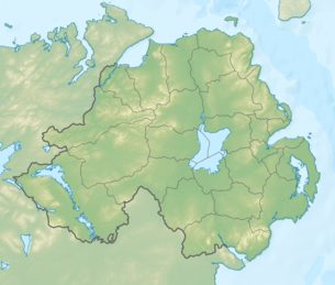
Cuilcagh (from Irish: Binn Chuilceach, meaning "chalky peak"[3]) is a mountain on the border between County Fermanagh (in Northern Ireland) and County Cavan (in the Republic of Ireland). With a height of 665 metres (2,182 ft) it is the highest point in both counties. It is also the 170th highest peak on the island of Ireland, and Ireland's only cross-border county top.[4] Water from the southern slope flows underground until it emerges some miles away in the Shannon Pot, the traditional source of the River Shannon. The area is sometimes referred to as the Cuilcagh Mountains.[1][5]
| Cuilcagh | |
|---|---|
| Binn Chuilceach | |
 Cuilcagh Mountain, viewed from Belmore Mountain | |
| Highest point | |
| Elevation | 665 m (2,182 ft) [1] |
| Prominence | 570 m (1,870 ft) [1] |
| Listing | County Top (Cavan and Fermanagh), P600, Marilyn, Hewitt |
| Coordinates | 54.200°N 7.811°W |
| Naming | |
| English translation | calcareous/chalky peak |
| Language of name | Irish |
| Pronunciation | Irish: [bʲiːnʲ ˈxɪlʲcəx] |
| Geography | |
 Cuilcagh Location in Ulster | |
| Location | Fermanagh, Northern Ireland & Cavan, Republic of Ireland |
| OSI/OSNI grid | H123280 |
| Topo map | OSi Discovery 26 |
| Climbing | |
| Easiest route | Cuilcagh Boardwalk Trail (Stairway to Heaven) |
| Official name | Cuilcagh Mountain |
| Designated | 31 December 1998 |
| Reference no. | 968[2] |
Naming
The name Cuilcagh comes from the Irish Cuilceach, which has been translated as "chalky". However, the mountain is mainly sandstone and shale, covered with bog and heather. The cliff-edged summit surface of the mountain is formed from the hard-wearing Lackagh Sandstone which itself overlies the Briscloonagh Sandstone. "It is possible that the name refers to the limestone rock on the lower northern flanks, namely the Glencar and Dartry Limestone formations.[6] Here a number of streams disappear below ground at swallow holes named Cats Hole, Pollawaddy, Pollasumera and Polliniska, all forming part of the Marble Arch cave system. If so, the name would mean 'calcareous' rather than 'chalky'".[7] It has also been called Slieve Cuilcagh in English,[8] 'Slieve' being an anglicisation of Sliabh ("mountain").
In the 1609 Plantation of Ulster, Cuilcagh formed part of lands which were granted to John Sandford of Castle Doe by letters patent dated 7 July 1613 (Pat. 11 James I – LXXI – 38, Quilkagh).[9][10] It was later sold by Sandford to his wife's uncle Toby Caulfeild, 1st Baron Caulfeild, Master of the Ordnance and Caulfield had the sale confirmed by letters patent of 12 July 1620 (Pat. 19 James I. XI. 45, Quilkagh).
Nature

Cuilcagh Mountain has one of the largest expanses of blanket bog in Northern Ireland, on a relatively high elevation upland landscape, bounded by limestone grassland to the north and montane habitats to the south. The blanket bog exhibits a wide range of characteristic vegetation and structural features, with well-developed pool, hummock and lawn features, acid flushes and bog bursts. The bog vegetation is characterised by luxuriant Sphagnum mosses but over most of the site dwarf-shrubs and graminoid herbaceous species dominate. The Cuilcagh area supports a rich assemblage of upland insects, and is one of the most important sites in Ireland for these species. Species recorded include the water beetles Agabus melanarius, Agabus arcticus, Dytiscus lapponicus, Stictotarsus multilineatus, Hydroporus longicornis and Hydroporus morio and the water bugs Glaenocorisa propinqua and Callicorixa wollastoni. Lough Atona is the main locality for these species.[11]
Conservation

The Cuilcagh Mountain Park was opened by Fermanagh District Council in 1998.[12]
Ramsar site
The Cuilcagh Mountain Ramsar site (wetlands of international importance designated under the Ramsar Convention), is 2744.45 hectares in area, at latitude 54 13 26 N and longitude 07 48 17 W. It was designated a Ramsar site on 31 December 1998. The site qualified under Criterion 1 of the Ramsar Convention because is a large and relatively intact example of a blanket bog and one of the best examples of this habitat in the United Kingdom. It also contains a comparatively high-altitude example of an oligotrophic lake, Lough Atona. The site also qualified under Criterion 2 because it supports numbers of rare, vulnerable or endangered species. It is one of the most important upland breeding sites in Northern Ireland for Eurasian golden plover, an Irish Red Data Book species. The merlin, which is also an Irish Red Data Book species, occurs on the site too. The bog is also occasionally used for feeding by greater white-fronted geese.[11]
Geopark
In 2001 the Cuilcagh Mountain Park was joined with popular tourist attraction the Marble Arch Caves and the Cladagh Glen Nature Reserve to make one of the first UNESCO-recognised European Geoparks.[12] This became a Global Geopark in 2004. In September 2008 the Marble Arch Caves Global Geopark was expanded into County Cavan, making it the world's first transnational cross-border Geopark.[12] The Geopark is protected and managed by Fermanagh & Omagh District Council through the staff of the Marble Arch Caves Visitor Centre.[12]
Boardwalk trail
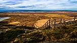
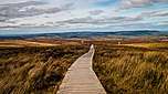
In 2015, the Cuilcagh Boardwalk Trail or Cuilcagh Legnabrocky Trail (and also called "The Stairway to Heaven") was opened up to preserve and protect the underlying peatland bog from erosion; however the trail led to a dramatic rise in visitors to Cuilcagh from circa 3,000 per annum to over 60,000.[13]
The wooden trail is 7.5 kilometers long and is part of the longer Legnabrocky trail.[14] The popularity of the trail has led to concerns over the ability of the area to handle the increased visitors to the trail.[15]
See also
| Wikimedia Commons has media related to Cuilcagh Mountain. |
Further reading
- Brown, Leslie (2005). "Inception and subsequent development of conduits in the Cuilcagh karst, Ireland". Doctoral thesis, University of Huddersfield. Retrieved 29 July 2012. Cite journal requires
|journal=(help)
References
- "Cuilcagh/Cuilcagh Mountains". MountainViews Online Database. Retrieved 27 November 2019.
- "Cuilcagh Mountain". Ramsar Sites Information Service. Retrieved 25 April 2018.
- Place Names NI - Cuilcagh
- "Cuilcagh". Mountainviews.ie. Retrieved 19 May 2007.
- John G. O'Dwyer (26 November 2019). "Blow off the Christmas cabin-fever with a walk for the season". Irish Times. Retrieved 27 November 2019.
Generally known as the Stairway to Heaven, this consists of a well-constructed new trail that conveys walkers high into the Cuilcagh Mountains.
- http://mapapps2.bgs.ac.uk/GSNI_Geoindex/home.html
- Tempan, Paul. Irish Hill and Mountain Names. MountainViews.ie.
- Fullarton, A (1856). A Gazetteer of the World: Volume 3. Royal Geographical Society. p. 527. Retrieved 1 August 2010.
- "Designated and Proposed Ramsar sites in Northern Ireland" (PDF). Joint Nature Conservation Committee. Retrieved 7 July 2008.
- "Marble Arch Caves Global Geopark – IRELAND". European Geoparks Network. Retrieved 16 August 2014.
- Andrea Smith (2 May 2017). "Why this 'Stairway to Heaven' in Ireland has become a social media star". Lonely Planet. Retrieved 7 July 2019.
Nicknamed the ‘stairway to heaven,’ the boardwalk opened in 2015 with an aim of conserving pristine blanket bog and restoring damaged peatland that had been eroded by people walking through it.
- Mark McConville (17 April 2019). "WATCH: Ireland's very own Stairway to Heaven! Weekend walk, anyone?". Irish Independent. Retrieved 7 July 2019.
The stunning wooden structure is found on Fermanagh's Cuilcagh Way - specifically, along the 7.5km Legnabrocky trail.
- Chris McCullough (29 April 2017). "How Fermanagh's amazing 'stairway to heaven' has become a victim of its own success". Belfast Telegraph. Retrieved 7 July 2019.
External links
- Cuilcagh Boardwalk Trail, WalkNI (2018)
- Ireland's own "Stairway to Heaven" (Cuilcagh Boardwalk Trail, Irish Independent (April 2017)
- Cuilcagh Legnabrocky Boarded Mountain Trail, Marble Arch Caves Global Geopark (July 2015)
| British Isles |  | |
|---|---|---|
| Scotland | ||
| Outside Scotland | ||
| England | ||
| Ireland | ||
| County tops | ||
Most prominent mountains of Britain and Ireland (the P600s) | ||
|---|---|---|
| Northern Highlands (20) | 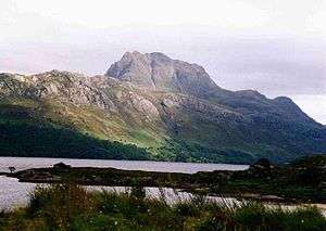   | |
| Western Highlands (20) | ||
| Central and Eastern Highlands (13) | ||
| Southern Highlands (15) |
| |
| Islands (13) | ||
| Scottish Lowlands, England and Wales (13) | ||
| Republic of Ireland, Northern Ireland (25) | ||
Mountains and hills of Ulster | ||
|---|---|---|
| Antrim Hills |  | |
| Antrim Plateau | ||
| Belfast Hills | ||
| Croaghgorms | ||
| Derryveagh | ||
| Inishowen | ||
| Mournes | ||
| Sperrins | ||
| Southwest Donegal | ||
| Others | ||
.jpg)