Colson Track
The Colson Track is a remote dirt track in Australia running between the Simpson Desert in South Australia and Numery Station in the Northern Territory.[3] It is named in honour of Ted Colson, the first person of European descent to make a successful crossing of the Simpson Desert on foot.[4]
Colson Track –Northern Territory | |
|---|---|
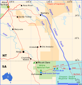 | |
The Colson Track (blue and white) | |
| General information | |
| Type | Track |
| Length | 336 km (209 mi) |
| Major junctions | |
| SSE end | Simpson Desert |
| NNW end | Numery Station |
| Location(s) | |
| Region | Central Australia[1] Far North[2] |
| Restrictions | |
| Permits | required |
Description
The southern terminus of the track is at a junction with the Rig Road in the western Simpson Desert, and the northern terminus is marked by a sign near the boundary of Numery Station. The length of the track is 336 km, much of which is in swales between sand dunes. The track is defined only by wheel ruts, but it may disappear with washouts and long grass making navigation difficult. The surface is mostly red sand and may be corrugated. The track should be negotiated by four-wheel drive high clearance vehicles only, and a permit to cross Aboriginal land is required. Additional permits are required for travel across the Simpson Desert.
References
- "investNT - Northern Territory Interactive Map". Archived from the original on 5 June 2010. Retrieved 24 April 2014.
- "Far North SA government region" (PDF). The Government of South Australia. Retrieved 16 August 2015.
- Hema, Maps (2007). Australia Road and 4WD Atlas (Map). Eight Mile Plains Queensland: Hema Maps. p. 100. ISBN 978-1-86500-456-3.
- Madigan, Cecil (2001). Crossing the Dead Heart. Marleston S.A.: J.B.Books. p. 11. ISBN 1-876-622-164.
Road infrastructure in South Australia | ||
|---|---|---|
| Freeways |
| |
| Interstate highways | ||
| State highways | ||
| Arterial roads |
| |
| Outback tracks | ||
Road infrastructure in Northern Territory | ||
|---|---|---|
| National highways | ||
| Highways | ||
| Major urban roads | ||
| Outback tracks and numbered state routes | ||