Oodnadatta Track
The Oodnadatta Track is an unsealed 617 km (383 mi) outback road in the Australian state of South Australia passing from Marree in the south-east to Marla in the north-west via Oodnadatta.[2] Along the way, the track passes the southern lake of the Kati Thanda-Lake Eyre National Park, the settlements of William Creek and Oodnadatta,[3] and mound springs known as Freeling Springs, Strangways Springs, and The Bubbler and Blanche Cup (Wabma Kadarbu Mound Springs).[4]
Oodnadatta Track | |
|---|---|
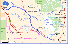 | |
Oodnadatta Track (depicted in blue) | |
| General information | |
| Type | Track |
| Length | 617 km (383 mi) |
| Major junctions | |
| NW end | Marla |
| SE end | Birdsville Track, Marree |
| Location(s) | |
| Region | Far North[1] |
| Restrictions | |
| Fuel supply | Marla, Oodnadatta, William Creek, Marree |
| Facilities | airstrips, charters at all towns, UHF Radio repeaters with 100 km range on various channels provide emergency contact with locals. Swimming pools and police stations at Oodnadatta and Marla |
History
The track follows a traditional Australian Aboriginal trading route. Along the Track are numerous springs feeding water from the Great Artesian Basin, the most accessible examples being the mound springs near Coward Springs (now in Wabma Kadarbu Mound Springs Conservation Park). Later, because of the availability of water, the route was chosen for the steam-train powered Central Australia Railway, the original route of The Ghan.
It was also the route taken by the explorer John McDouall Stuart on his third expedition in 1859.[5] Remnants of the many railway sidings and bridges, the ruins of railway buildings, and Overland Telegraph Line repeater stations are located along the track – some of the best preserved are the Coward Springs Campground – complete with natural artesian spa and the abandoned Curdimurka railway siding.
Angle Pole (27°30′13″S 135°24′57″E) is the point near Oodnadatta where the direction of the Telegraph Line changed to a more northerly direction.[6] It is near the Peake cattle station,[7][8] also known as "The Peake", or Freeling Springs. The ruins of Peake telegraph station exist on the station today.[9] Nearby Peake Creek was named after Edward John Peake by John McDouall Stuart in June 1859, hence Peake Station, which was acquired by Kidman Holdings in 1898.[10]
The Track was named by Adam Plate of the Oodnadatta Progress Association in about 1980 to form a trilogy of unsealed tourist routes with the Birdsville and Strzelecki Tracks nearby. This Road has no major intersections.
Route
The Oodnadatta Track roughly follows the former railway line as far north as Oodnadatta, and then turns to the west, meeting the sealed Stuart Highway at Marla. The road's surface has been well maintained in recent years. In dry weather, the track is passable to most vehicles and caravans, but a four-wheel drive (4x4) vehicle gives a more comfortable journey, and is essential for driving the track during and after rain. Since the track is unsealed, the Government of South Australia recommends that users of the track check if the track is open before departure.[11]
Gallery
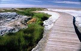 Mound Springs on the Oodnadatta Track.
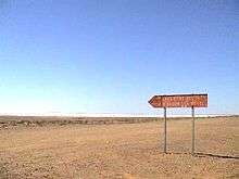 Lake Eyre South from Oodnadatta Track
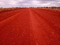 The Oodnadatta Track heading North from Oodnadatta
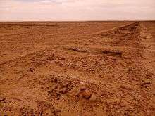 Sleepers of the old Ghan line in the bed of Lake Eyre South
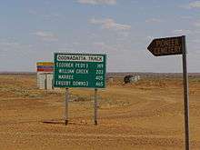 Road signage at Oodnadatta, 2007
References
- "Far North (South Australian Government Region)" (PDF). The Government of South Australia. Retrieved 19 June 2015.
- Hema, Maps (2007). Australia Road and 4WD Atlas (Map). Eight Mile Plains Queensland: Hema Maps. pp. 72–73. ISBN 978-1-86500-456-3.
- "Oodnadatta Track: Wiliam Creek, Coward Springs & Pink Roadhouse" In Australien. Retrieved 2015-09-10.
- "About mound springs". Friends of Mound Springs. Retrieved 28 May 2019.
- "Outback: The Oodnadatta Track". National Roads and Motorists' Association (NRMA). Archived from the original on 6 August 2008. Retrieved 24 June 2008.
- http://www.exploroz.com/Places/77748/SA/The_Angle_Pole_Memorial.aspx
- "Railway Construction In Western Australia". The Sydney Morning Herald. National Library of Australia. 14 February 1889. p. 7. Retrieved 28 December 2012.
- "Search result for "Angle Pole" (Record No. SA0001492)". Department of Planning Transport and infrastructure. 1 July 2004. Archived from the original on 12 October 2016. Retrieved 29 October 2015.
- "Freeling Springs (The Peake)". Friends of Mound Springs. Retrieved 28 May 2019.
- "S.A. Northern Pioneers: S. Jarvis". SA Memories. State Library of South Australia. Retrieved 25 July 2019.
- "Outback Road Names Sheet 1 of 5 (North West)" (PDF). Department of Planning, Transport and Infrastructure. 21 January 2014. Retrieved 3 October 2019.
Further reading
- "Oodnadatta Track facts & introduction: From Marree to Marla - a detailed travel guide". Rita's Outback Guide.
- "Oodnadatta Track Guide". Travel Outback Australia.
- Eime, Roderick. "Tracking History to Oodnadatta". Travography.
- Government of South Australia & BHP Billiton, The Oodnadatta Track - String of Springs, PDF available online, pp. 20 pages
External links


Road infrastructure in South Australia | ||
|---|---|---|
| Freeways |
| |
| Interstate highways | ||
| State highways | ||
| Arterial roads |
| |
| Outback tracks | ||