North–South Corridor, Adelaide
The North–South Corridor is a series of road projects currently under construction or planning which travel through Adelaide, South Australia that will eventually form a continuous link from Old Noarlunga in the outer southern metropolitan Adelaide suburbs through to Nuriootpa in the inner northern rural area around the Barossa Valley, a distance of over 100 km, aiming to be without a single stop by 2030.
North–South Corridor | |
|---|---|
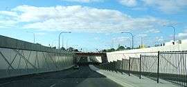 | |
South Road Underpass beneath Anzac Highway | |

| |
| General information | |
| Type | Road |
| Length | 107 km (66 mi) |
| Route number(s) | |
| Major junctions | |
| South end | |
| North end | |
| Location(s) | |
| Major suburbs | Bedford Park, Black Forest, Glandore, Angle Park, Globe Derby Park, Bolivar, Waterloo Corner, Virginia, Penfield, Andrews Farm, Angle Vale, Gawler |
The route comprises a number of major road links in the metropolitan area with the final product culminating as, from north to south, the Northern Expressway, the North–South Motorway, and the Southern Expressway.

Road links
By 2030, all of these major road links are proposed to have been completed, thus making a major route through the Adelaide metropolitan area a much more efficient way to travel. Its expected to take only one hour to travel from Noarlunga in the South to Gawler in the North. When announced, the incumbent government had a strategy to deliver the complete project in ten years from May 2015.[1]
The components identified by the Department of Planning, Transport and Infrastructure, from north to south, are:[2]
| Road | Status | Opened | |
|---|---|---|---|
| Northern Expressway | Complete | 13 September 2010 | |
| North–South Motorway |
Northern Connector | Complete | 7 March 2020 |
| South Road Superway | Complete | 13 March 2014 | |
| Regency Road to Pym Street | Under construction | planned 2022 | |
| Torrens Road to River Torrens | Complete | 29 September 2018 | |
| River Torrens to Anzac Highway | Unfunded | ||
| Anzac Highway to Darlington | Unfunded | ||
| Southern Expressway | Darlington Upgrade | Under construction | planned 2020 |
| Duplication | Complete | 3 August 2014 | |
Sturt Highway
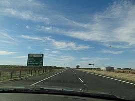
The Sturt Highway continues the north–south motor traffic corridor to Nuriootpa as a dual carriageway road with the second carriageway added between 2007 and 2009, providing a total of two lanes in each direction. The Sturt Highway continues beyond Nuriootpa as just one lane each way. The next major bottleneck is the town of Truro which has the highway as its main street. A bypass is proposed in 5 to 15 years from the 2015 integrated plan.[3]
Northern Expressway
The Northern Expressway opened in September 2010 and was subsequently named the Max Fatchen Expressway, as the longest new road project in South Australia for a number of decades. Max Fatchen was a popular author and journalist who had grown up and lived most of his life in the area traversed by the expressway. The 4 lane highway extends from Port Wakefield Road, northwest through 5 interchanges in Penfield (2 interchanges), Andrews Farm, Angle Vale and Gawler River to where it joins the Sturt Highway just outside Gawler.
Cycling is prohibited on the expressway. The Stuart O'Grady Bikeway was constructed in conjunction with the expressway and follows the southeastern side of it.
North–South Motorway
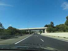
The North–South Motorway is an incomplete planned motorway traversing the inner western suburbs of Adelaide from Waterloo Corner and Virginia in the north to Bedford Park in the south. As a free-flowing north-south route it will be the primary route through Adelaide, bypassing the traffic light intersections along Port Wakefield Road and South Road, and will connect the Northern Expressway and Southern Expressway.
For the purposes of construction planning, the motorway is divided into six sections of which three are complete and one is under construction. From north to south are the Northern Connector (completed 2020); the South Road Superway (completed 2014); Regency Road to Pym Street which is under construction (projected completion 2022); Torrens Road to River Torrens (completed 2018); River Torrens to Anzac Highway which is unfunded; and Anzac Highway to Darlington which is unfunded but presently has traffic congestion mitigated by the Gallipoli Underpass (completed 2009), the Glenelg Tram Overpass (completed 2009), and Emerson Crossing (completed 1985).
Southern Expressway
The Southern Expressway opened in two stages in 1997 and 2001 respectively, as a one way freeway which was closed for an hour twice a day, and reversed direction to match peak traffic flow; open northwards (towards city) weekday mornings and weekend afternoons, and open southwards (away from city) weekday afternoons and weekend mornings. Duplication of the Expressway began in 2011, with the construction of a second carriageway allowing the expressway to operate in both directions at all hours. The duplication opened on 3 August 2014.[4]
The northern terminus of the expressway is at Main South Road in St Marys where it runs through Bedford Park in an open cutting adjacent to Main South Road on the surface; this section began construction in 2016 (projected completion 2020) replacing the original northern terminus, a signalised intersection further south, and bypassing five sets of traffic lights on Main South Road.
The southern terminus of the expressway is at Main South Road, Old Noarlunga. Northbound traffic has free-flowing entry onto the roadway, whereas southbound travellers have a set of traffic lights to exit the expressway. Heading south after the expressway, Victor Harbor can be accessed with one additional set of traffic lights, and traffic to Cape Jervis only encounters three more sets of lights.
See also
![]()
References
- "North–South Corridor The 10 year Strategy" (PDF). Department of Planning, Transport and Infrastructure. May 2015. K-Net #9526649, V1. Retrieved 6 April 2016.
- "Adelaide's North-South Corridor". Department of Planning, Transport and Infrastructure South Australia. Retrieved 12 December 2015.
- "The Integrated Transport and Land Use Plan" (PDF). Government of South Australia. July 2015. p. 149. Retrieved 30 April 2018.
- "Southern Expressway Duplication". Department of Planning, Transport and Infrastructure. Retrieved 1 September 2014.
- Department of Planning, Transport and Infrastructure (19 September 2012). "Adelaide's north-south corridor". Government of South Australia. Retrieved 28 December 2013.