Wimmera Highway
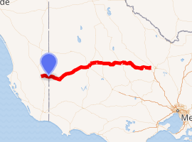
Wimmera Highway is a 345 kilometre highway that connects the towns of Marong, Victoria and Naracoorte, South Australia, through the major junctions of Sunraysia Highway, Henty Highway and Western Highway.
Wimmera Highway –South Australia | |
|---|---|
 | |
Wimmera Highway passing through Rupanyup | |
| |
| General information | |
| Type | Highway |
| Length | 345 km (214 mi) |
| Route number(s) |
|
| Former route number | |
| Major junctions | |
| East end | |
| |
| West end | |
| Location(s) | |
| Major settlements | Newbridge, Moliagul, St Arnaud, Rupanyup, Murtoa, Horsham, Natimuk, Edenhope, Apsley |
| Highway system | |
Major intersections
| State | LGA | Location[1] | km | mi | Destinations | Notes |
|---|---|---|---|---|---|---|
| Victoria | Greater Bendigo | Marong | ||||
| Loddon | Newbridge | |||||
| Llanelly | ||||||
| Tarnagulla | ||||||
| Moliagul | ||||||
| Logan | ||||||
| Northern Grampians | St Arnaud | |||||
| Marnoo | ||||||
| Rupanyup | ||||||
| Yarriambiack | Murtoa | |||||
| Horsham | Dooen | |||||
| Horsham | ||||||
| Natimuk | ||||||
| West Wimmera | Miga Lake | |||||
| Edenhope | ||||||
| State border | Victoria – South Australia state border | |||||
| South Australia | Naracoorte Lucindale | Naracoorte | ||||
| 1.000 mi = 1.609 km; 1.000 km = 0.621 mi | ||||||
References
- Google. "Marong to Naracoorte" (Map). Google Maps. Google.
External links
![]()
Road infrastructure in South Australia | ||
|---|---|---|
| Freeways |
| |
| Interstate highways | ||
| State highways | ||
| Arterial roads |
| |
| Outback tracks | ||
Road infrastructure in Victoria | ||
|---|---|---|
| Freeways |
| |
| Highways |
| |
| Bypass routes | ||
| Tourist routes | ||
This article is issued from Wikipedia. The text is licensed under Creative Commons - Attribution - Sharealike. Additional terms may apply for the media files.