Great Central Road
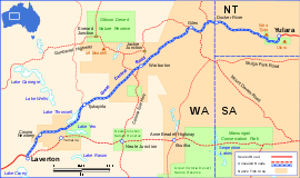
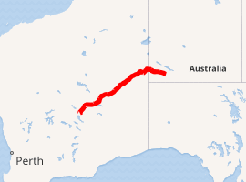
The Great Central Road is a mostly unsealed Australian outback highway that runs 1,126 km (700 mi) from Laverton, Western Australia to Yulara, Northern Territory (near Uluru/Ayers Rock).[1][2] It passes through a number of small communities on the way.
Great Central Road –Northern Territory | |
|---|---|
 | |
Great Central Road (blue and white) | |
| |
| General information | |
| Type | Track |
| Length | 1,126 km (700 mi) |
| Major junctions | |
| WSW end | Laverton |
| ENE end | Yulara |
| Restrictions | |
| Permits | 2 required |
| Fuel supply | Laverton (28°37′S 122°24′E), Cosmo Newberry, Tjukayirla Roadhouse, Warburton (26°13′S 126°39′E), Warakurna Roadhouse, Docker River and Yulara (25°14′S 130°59′E) |
History
The Great Central Road has its origins in the early 1930s when Warburton was established as a missionary settlement, and supplies were delivered from Laverton via a rough bush track.[3][4]
By the mid 1950s, the track from Laverton had become graded dirt. In 1958 during survey for the Gunbarrel Highway as part of the Woomera rocket range project, Len Beadell visited Warburton and built a new road from Giles via the Rawlinson Range to Warburton. At Jackie Junction 69 km (43 mi) north of Warburton, the Gunbarrel Highway branched from this road towards Carnegie Station further west. Beadell returned to Giles via a different bush track which passed east through the Blackstone Range towards Docker River.[5]
In January 1978 funds were provided to Warburton council by the Western Australian Government to construct a more direct road from Warburton to Docker River which bypassed part of the twenty-year-old Gunbarrel Highway.[6] The Great Central Road and original Gunbarrel Highway are coincident for 45 km (28 mi) near Giles.[1]
Present conditions
Though still recommended only for four wheel drive vehicles, the road is now graded to a standard suitable for two wheel drive vehicles and caravans. It is on the most direct route from Perth to Uluru (Ayers Rock), with approximately 10,000 vehicles travelling the route annually.
When heading from the Northern Territory to Laverton there is an Amnesty Bin for Quarantine WA 20 km (12 mi) outside of Laverton. All passenger vehicles are to stop and dispose of all quarantine risk material that is stated on the sign, including all fresh fruit, vegetables, honey, seed, potatoes, onions and other such plants. This area has a mobile inspector from time to time and there is risk of fines if travellers are stopped and offending material is found.
There are fuel supplies at the following locations along the route. The distances below are relative to Laverton.
- Cosmo Newbery – 85 km (53 mi),
- Tjukayirla Roadhouse – 300 km (190 mi),
- Warburton – 560 km (350 mi),
- Warakurna Roadhouse – 786 km (488 mi),
- Docker River – 890 km (550 mi) and
- Yulara – 1,126 km (700 mi).
It is recommended that communications equipment be carried while driving on this road. The route also passes directly into Aboriginal reserves and it is a legal requirement for travellers to hold a valid transit permit at the time of travel, even when staying on the Great Central Road.[7] Two permits are required and they are available from the Department of Planning, Lands and Heritage of the Government of Western Australia and the Central Land Council in the Northern Territory.[7][8] The permits are free.
Gallery
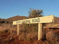 Sign near Giles Weather Station
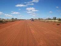 The Great Central Road is of suitable standard for 2WD vehicles
Attractions
The two most notable attractions on this road are Kata Tjuta (the Olgas) and Uluru (Ayers Rock), both within the Uluru-Kata Tjuta National Park in the Northern Territory.
Other attractions include Tjukayirla Roadhouse, which takes its name from the Tjukayirla Rockholes, situated at the southwest end of the campground. Adjacent to the rockholes is the Paine and Barclay Surveyor marker which was placed by the surveyors in early 1930s during the original survey route to Warburton.
There is a large variety of wildlife in the area; at times dingos, emus, kangaroos and camels as well as a large variety of birds can be seen around the roadhouse. A breakaway on the southern side of the Roadhouse is known as 'The Zoo', due to the animals that can be seen in the shapes of the rocks, including an elephant. There are also escarpment caves within 5 km (3.1 mi) of the Roadhouse.
Empress Springs are located 60 km (37 mi) north along the David Carnegie Rd, the junction of which is along the Great Central Rd 15 km (9 mi) west of the roadhouse. The road is marked as 4WD only. The springs are inside a cave, access is via a chain ladder and there is a visitors book near the cave.
Lasseter's Cave, the Petermann Ranges, Giles Weather Station, the ochre bluff of Giles Breakaway, Lake Throssell, Lake Yeo Nature Reserve for wildflowers in spring, Peegull Waterhole and Caves, and Empress Spring.
Junctions
| State/Territory | LGA | Location | km[9] | mi | Destinations | Notes |
|---|---|---|---|---|---|---|
| Western Australia | Laverton | Laverton | 0 | 0.0 | ||
| Cosmo Newbery | 85 | 53 | ||||
| Ngaanyatjarraku | Tjukayirla Roadhouse | 307 | 191 | |||
| Warburton | 554 | 344 |
| Great Central Road is sometimes considered concurrent with Gunbarrel Highway between Warburton and Warakurna | ||
| Warakurna | 781 | 485 | Old Gunbarrel Highway | Also Giles Weather Station, Giles Airport | ||
| Warakurna | 807 | 501 | Gunbarrel Highway – Pipalyatjara, South Australia | |||
| Giles | 854 | 531 | Sandy Blight Junction Road – Kintore, Northern Territory | |||
| Northern Territory | MacDonnell Region | Kaltukatjara | 870 | 540 | (Formerly Docker River) Great Central Road in Western Australia; Tjukaruru Road in Northern Territory | |
| unincorporated area | Yulara | 1,110 | 690 | Lasseter Highway – Alice Springs, Darwin | ||
1.000 mi = 1.609 km; 1.000 km = 0.621 mi
| ||||||
See also
![]()
References
- Hema, Maps (2005). Australia’s Great Desert Tracks SW Sheet (Map). Eight Mile Plains Queensland: Hema Maps. ISBN 978-1-86500-161-6.
- Hema, Maps (2005). Australia’s Great Desert Tracks SC Sheet (Map). Eight Mile Plains Queensland: Hema Maps. ISBN 978-1-86500-164-7.
- Walker, Greg (2012), Great Central Road : The Outback Travellers Track Guide, Design Interaction, ISBN 978-0-9874125-2-2
- Royal Automobile Club of W.A; Royal Automobile Club of W.A. Mapping Section (1996), Perth - Alice Springs via "Gunbarrel Highway" or Great Central Road (9th ed.), RACWA, retrieved 10 July 2015
- Beadell, Len (1965). Too Long in the Bush. New Holland Publishers (Australia). ISBN 1864367199.
- "Roads General References Re Development". State Records Office of WA. Series S243 - Files - General [1], Item 76/1232. Retrieved 4 June 2018.
- "Entry permits for access to Aboriginal Lands". Department of Planning, Lands and Heritage. Government of Western Australia. 2019. Retrieved 6 April 2019.
- "Transit Permit Application". Central Land Council. 2019. Retrieved 6 April 2019.
- Google (20 January 2017). "Great Central Road" (Map). Google Maps. Google. Retrieved 20 January 2017.
External links
| Wikimedia Commons has media related to Great Central Road. |
Road infrastructure in Northern Territory | ||
|---|---|---|
| National highways | ||
| Highways | ||
| Major urban roads | ||
| Outback tracks and numbered state routes | ||
Road infrastructure in Western Australia | ||
|---|---|---|
| Freeways | ||
| Metropolitan highways | ||
| Highways and major roads |
| |
| Outback tracks | ||
| Lists |
| |