Plenty Highway
The Plenty Highway is a 498 kilometres (309 mi) outback mostly unsealed road in the Northern Territory of Australia between the Stuart Highway and north-western Queensland.[1]
Plenty Highway | |
|---|---|
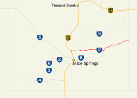 | |
Map of central Australia with Plenty Highway highlighted in red | |
| General information | |
| Type | Rural road |
| Length | 498 km (309 mi) |
| Route number(s) | |
| Major junctions | |
| West end | |
| East end | Donohue Highway, Tobermorey Homestead (NT/Queensland border) |
| Location(s) | |
| Major settlements | Atitjere, Huckitta, Jervois, Tarlton Downs |
The road begins at a turnoff from the Stuart Highway 68 kilometres (42 mi) north of Alice Springs, and finishes at Tobermorey Homestead on the Northern Territory/Queensland border. It then continues for another 249 kilometres (155 mi) to Boulia in Queensland, as the Donohue Highway.
The first 100 kilometres (62 mi) from the Stuart Highway to Ongeva Creek is sealed. The remaining 178 kilometres (111 mi) to Jervois Homestead is unsealed as is the rest of the track to Boulia. Information about its condition may be obtained from the Harts Range police station, 112 kilometres (70 mi) from the Stuart Highway.
East of Jervois Homestead, the road is formed earth, deteriorating to rocks and bulldust as it nears Tobermorey, 213 kilometres (132 mi) from Jervois Homestead. The road north to Urandangi and thence to Mount Isa bears left just before Tobermorey.
As at other Northern Territory or Queensland border crossings, the road may deteriorate east of the border into Queensland with deep potholes and bulldust. It is 249 kilometres (155 mi) from Tobermorey to Boulia and good camping may be found at the Georgina River, at about the 125 kilometres (78 mi) mark.
Fuel and food may be obtained at Gemtree, Atitjere community, Jervois Homestead and Boulia. As of June 2018, fuel and camping is available at Tobermorey. The Donohue Highway is not suitable for ordinary caravans and road trains up to 53 metres (174 ft) in length use both highways.
Junctions and localities
| Location[2] | km[2] | mi | Destinations | Notes | |
|---|---|---|---|---|---|
| Burt Plain | 68 kilometres (42 mi) north of Alice Springs | ||||
| Anmatjere | 27 | 17 | |||
| Gemtree | 70 | 43 | Caravan park, fuel available | ||
| Harts Range, Atitjere | 147 | 91 | Fuel available | ||
| Huckitta Station | 200 | 120 | |||
| Jervois Station | 277 | 172 | Fuel available | ||
| Tarlton Downs Station | 347 | 216 | |||
| Tobermorey | 492 | 306 | Urandangi Road – Urandangi, Mount Isa | ||
| Tobermorey Homestead | 496 | 308 | Continues into Queensland as Donohue Highway – Boulia | ||
| 1.000 mi = 1.609 km; 1.000 km = 0.621 mi | |||||
References
- Hema, Maps (2005). Australia's Great Desert Tracks NE Sheet (Map). Eight Mile Plains Queensland: Hema Maps. ISBN 978-1-86500-160-9.
- Google (21 January 2017). "Plenty Highway" (Map). Google Maps. Google. Retrieved 21 January 2017.
Road infrastructure in Northern Territory | ||
|---|---|---|
| National highways | ||
| Highways | ||
| Major urban roads | ||
| Outback tracks and numbered state routes | ||