Buckingham Canal
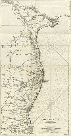
The Buckingham Canal is a 796 kilometres (494.6 mi) long fresh water navigation canal, that parallels the Coromandel Coast of South India from Kakinada City in the East Godavari district of Andhra Pradesh to Viluppuram District in Tamil Nadu. The canal connects most of the natural backwaters along the coast to Chennai (Madras) port. It was constructed during British Rule, and was an important waterway during the late nineteenth and early twentieth centuries.
Originally called Cochrane's Canal in 1806, it was briefly renamed Lord Clive's Canal before finally being named the Buckingham Canal in 1878. The name reflects the order of the Duke of Buckingham and Chandos — as Governor of Madras — who ordered the extension of the canal to help people affected by famine.[1]
It was first known as the North River by the British and was believed to be partly responsible for reducing cyclone damage to much of the Chennai - southern Andhra coastline.
Construction phases
Originally known as Cochrane's canal, the first segment of the canal was a saltwater navigation canal, constructed in 1806,[2] from Chennai North to Ennore for a distance of 18 km (11 mi). It was financed by Basil Cochrane. Subsequently, it was extended north to Pulicat Lake, 40 km (25 mi) north of Chennai. The canal was taken over by the government of Madras Presidency in 1837 and further extended, ultimately reaching 315 km (196 mi) north of Chennai to gudivada kalava on the banks of the Krishna River in Andhra Pradesh, and 103 km (64 mi) south of Chennai to Marakkanam in Tamil Nadu. When the canal was opened, it was named Lord Clive's Canal and later Buckingham Canal. However, the section in Chennai was known as Cochrane's Canal for much of the 19th century.[3]
During 1877 and 1878, the people of Chennai suffered from the terrible Great Famine and more than six million people perished. The 8 km (5 mi) stretch, linking the Adyar and Cooum rivers, was built in 1877–78 at a cost of ₹3 million (£33,000) as a famine relief work. The canal was named the Buckingham Canal in 1878 because the link, was built on the orders of the then Governor, the Duke of Buckingham and Chandos.
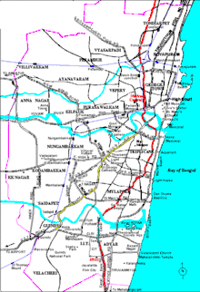
Course of the canal
One of the works to be undertaken in the Second Five Year Plan is the development of Buckingham Canal (including the linking of th-; Cana) with the Madras harbour) with a contribution of Rs. 115 lakhs by the Central Government. This work has been considered necessary to conserve an existing asset which is serving as an inter-state water-way supplementing the railway capacity and providing a useful means of transport for large quantities of goods between the States of Andhra and Madras. [4]
The Buckingham Canal which is a salt water canal runs through Madras, parallel and close to the Coromandel coast, at a distance of 3/4 to l/^ miles from the sea (high water mark) joining up a series of natural back waters, and fed by tidal waters from the ■sea through rivers and creeks.' It runs for 196 miles north of Madras (of which 36 miles are in Madras State, and 160 miles in Andhra State) and 64 miles south of Madras. In Andhra it joins the Cammamar Canal at the Krishna delta, which in turn is connected with the canals of the Godavari delta. The complete inter-connected system presents a continuous 400 miles of navigable channel along the coast. [5]
The canal, which has had a very chequered career, was constructed as far back as 1806 by a private individual Mr. Basil ■Cochrane, and is one of the earliest engineering feats of the Nineteenth century. A very interesting note, containing a brief history of the canal from 1806 to date, sent by the Ministry of Transport, is enclosed as Appendix V. It will be noticed that the canal which lost its importance for many years as a result o£ the competition of the railways, regained its importance since the Second World War. [6]
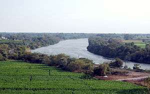
The canal runs approximately 1 km (0.62 mi) back from the coastline. The Cooum River connects the canal to the Bay of Bengal in the center of Chennai. The portion north of the Cooum is known as the North Buckingham Canal, and the portion south of the Cooum as the South Buckingham Canal. 257 km (160 mi) of the canal is in Andhra Pradesh, and 163 km (101 mi) is in Tamil Nadu. Approximately 31 km (19 mi) is within the city limits of Chennai.
| Stretch | Original (survey) width (m) | Existing width (m) | ||
|---|---|---|---|---|
| Minimum | Maximum | Minimum | Maximum | |
| Adyar River–Greenways Road | 107 | 116 | 25 | 31 |
| Greenways Road–Kamaraj Salai | 115 | 123 | 25 | 33 |
| Kamaraj Salai–Venkatakrishna Road | 98 | 123 | 33 | 48 |
| Venkatakrishna Road–St. Mary's Road | 122 | 123 | 37 | 38 |
| St. Mary's Road–Agraharam Road | 133 | 143 | 28 | 38 |
| Agraharam Road–Kutchery Road | 113 | 117 | 33 | 37 |
| Kutchery Road–P.V.Koil Street | 114 | 134 | 34 | 39 |
| P.V.Koil Street–Radhakrishna Street | 117 | 133 | 25 | 38 |
| Radhakrishna Street–Avvai Shanmugam Salai | 120 | 122 | 30 | 32 |
| Avvai Shanmugam Salai–Besant Road | 100 | 109 | 25 | 34 |
| Besant Road–Barathi Salai | 89 | 110 | 24 | 25 |
| Barathi Salai–Wallaja Road | 80 | 111 | 30 | 36 |
| Wallaja Road–Swami Sivanandha Salai | 42 | 73 | 32 | 36 |
| Swami Sivanandha Salai–Cooum River | 80 | 93 | 25 | 28 |
Decline in usage
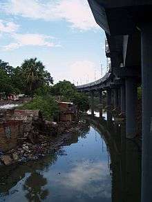
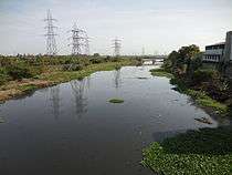
The canal was used to convey goods up and down the coast from Vijayawada to Madras (now Chennai). The cyclones of 1965/1966 and 1976 damaged the canal, and it is little used and no longer well maintained. Within the city of Chennai the canal is badly polluted from sewage and industrial effluents, and the silting up of the canal has left the water stagnant, creating an attractive habitat for malaria-spreading mosquitoes. The North Chennai Thermal Power Station (NCTP) discharges hot water and fly ash into the canal. In agricultural areas south of Chennai, the former tow path along the scenic areas is used for light motorcycle and bicycle traffic. On 1 January 2001 the Government of India launched a project to prevent sewage discharge into the canal and Chennai's other waterways, and to dredge the canal to remove accumulated sediment and improve water flow.
Within the city limits of Chennai much of the canal has been used as the route of the elevated Chennai Mass Rapid Transit System (MRTS). MRTS stations such as Kotturpuram, Kasturba Nagar and Indira Nagar have encroached on the canal and narrowed the width of the canal to less than 50 meters in a few places.[7]
Buckingham Canal is the most polluted of the three major waterways in the city with nearly 60 per cent of the estimated 55 million litres of untreated sewage being let into it daily, including by Chennai Metropolitan Water Supply and Sewerage Board.[8]
Effect of the 2004 tsunami
Dr. B. Ramalingeswara Rao first identified the buffer zone action of the Buckingham Canal when he visited the coastal areas of 300 kilometres (186.4 mi). He recommended to the Government to renovate it to mitigate tsunami hazards in the future. Further, he reported in 2005, during the 2004 Indian Ocean tsunami, the Buckingham Canal acted as a buffer zone and regulated the tsunami waves on the coastal region over nearly 310 kilometres (192.6 mi) from Pedda Ganjam to Chennai. The canal all along the coast was filled with tsunami water, which overflowed at a few places and receded back to sea within 10-15 min. This helped save the lives of several fishermen, especially in coastal Andhra Pradesh and parts of Chennai city and also helped in clearing of the aquaculture debris. The natural growth of vegetation on either side of the canal, has had an effect in tsunami mitigation; for example in Vakadu Mandal at villages like Pudikappam, Srinivasapuram and Tudipalem, the damage was minimal.
Dr. B. R. Rao further stressed on the extension of the Buckingham Canal up to Vedaranyam in order to protect the Tamil Nadu coast from the fury of tsunamis in future. The maximum magnitude MW 8.5 may occur in future in Sumatra because of its continuous subduction activity.
Cause of 2015 floods
Buckingham canal drains water from south Chennai. A 2014 CAG report revealed that a diversion channel from Buckingham canal near Okkiyum Maduvu to the sea (drain project under JNNURM scheme) could have saved south Chennai from flooding. But the government dropped the 100 crore JNNURM scheme, which if completed, would have drained flood water at 3,500 cubic feet per second from southern neighborhoods. The 2014 CAG report said defective planning of flood control projects caused delay and increased cost, defeating the objective of the scheme. "The fact is that alleviation of inundation of flood water in Chennai city remains largely un-achieved," it said.[9]
Revamp of the canal
Revival of Buckingham Canal took shape by government's National Waterway 4 (NW-4) declaration on November 2008. Both North Buckingham (Peddakanjam, Ongole-Chennai) and south Buckingham (basin bridge, Chennai - Marakkanam) canal will be developed under the proposed National Waterway 4 by Inland Waterways Authority of India. Periodically, government of Tamil Nadu also takes up dredging and widening of the canal through Water Resources Department, Public Works Department (PWD). With the provisions of State-Center shared Jawaharlal Nehru National Urban Renewal Mission (JNNURM), PWD has started widening the South Buckingham Canal from Okkiyam Madu to Muttukadu for a stretch of 13.5 kilometres (8.4 mi)[10] About ₹1,447.91 crore (US$200 million) has been allocated under the JNNURM for integrated development of waterways and macro drainages like Buckingham canal, Otteri Nullah, Virugambakkam – Arumbakkam drain, Cooum and Adyar river.[11] Despite of the development, the central section of the canal running through the most congested areas of Chennai, a length of 7.1 kilometres (4.4 mi) will remain unnavigable due to severe encroachments and construction of the Chennai Mass Rapid Transport System.
On 22 January 2010, Government of Tamil Nadu has reconstituted the Adayar Poonga Trust as Chennai River Restoration Trust for restoration of Chennai rivers (Adayar river, Cooum river) including the Buckingham Canal.
In 2011 improvements were being undertaken on the 13 km (8.1 mi) stretch between Okkiyam Madu and Muttukadu under the Jawaharlal Nehru National Urban Renewal Mission. The canal was being widened to 100 m (330 ft) and a U.S.A. built dredge was being used to deepen the canal to 2.4 m (8 ft). Also under this project, six small causeways across the canal would be reconstructed into single-lane bridges[12]
Bridges connecting ECR and OMR
In 2018, the Chennai Corporation proposed to construct six bridges across the canal, linking East Coast Road and Old Mahabalipuram Road, along a length of 4.5 kilometers of the canal. They include Venkatesapuram–Elango Nagar (costing ₹ 46.3 million), Venkatesapuram–Gandhi Road (costing ₹ 46.2 million), Kamarajar Salai–Veeramani Salai (costing ₹ 60 million), Maniammai Street–Dr. Ambedkar Salai (costing ₹ 96.6 million), Pandian Street–Anna Nagar (costing ₹ 62.1 million), and Gandhi Nagar–Pandian Nagar (costing ₹ 52.9 million).[13]
See also
- Cooum river
- Adyar river
- Kosasthalaiyar river
- Water management in Chennai
References
| Wikimedia Commons has media related to Buckingham Canal. |
- "An ambitious plan to revive the Buckingham Canal". The Hindu. Archived from the original on 9 May 2018. Retrieved 5 August 2017.
- Jan Lundqvist, Paul Appasamy (November 1998). "Water Supply and Waste Disposal Strategies for Madras". Ambio. Allen Press on behalf of Royal Swedish Academy of Sciences. 22 (7): 442–448. JSTOR 4314123.
- Darvill, Simon (December 2011). "India's First Railways". Indian Railways Fan Club. Retrieved 3 November 2012.
- https://eparlib.nic.in/bitstream/123456789/5047/1/ec_1_61_1957.pdf page 20
- https://eparlib.nic.in/bitstream/123456789/5047/1/ec_1_61_1957.pdf page 21
- https://eparlib.nic.in/bitstream/123456789/5047/1/ec_1_61_1957.pdf page 22
- Encroachment of MRTS stations on the Canal
- Lakshmi, K.; Deepa H Ramakrishnan (29 September 2011). "Untreated sewage pollutes waterways". The Hindu. Chennai: The Hindu. Retrieved 2 October 2011.
- "Flood: Chennai corpn learned little from CAG advice - Times of India". indiatimes.com. Archived from the original on 6 July 2017. Retrieved 9 May 2018.
- The Hindu (25 July 2010) (25 July 2010). "South Buckingham Canal widening". Chennai, India. Archived from the original on 14 October 2010. Retrieved 5 August 2010.
- Public Works Department, Government of Tamil Nadu. "Policy Note (2010-2011), Public Works Department of Tamilnadu" (PDF). Archived from the original (PDF) on 6 August 2011. Retrieved 5 August 2010.
- K. Lakshmi (25 January 2011), "Imported machinery deployed to desilt South Buckingham canal", The Hindu, Chennai: Bennett, Coleman & Co. Ltd, archived from the original on 30 January 2011, retrieved 26 January 2011
- Lopez, Aloysius Xavier (20 October 2018). "Six bridges to link ECR, OMR". The Hindu. Chennai: Kasturi & Sons. Retrieved 20 October 2018.
- "Buckingham canal buffered tsunami fury". The Hindu Aug 11, 2005. Chennai, India: The Hindu Group. 11 August 2005. Retrieved 15 May 2006.
- "The desecrated link". The Hindu Sep 23, 2002. Hindu Group. Archived from the original on 7 May 2005. Retrieved 15 May 2006.
B. Ramalingeswara Rao (2005). buckingham Canal saved people in Andhra Pradesh (India) from the tsunami of 26 December 2004. current Science vol. 89, 12–13.