Ceylanpınar
Ceylanpınar (Kurdish: Serêkaniyê,[3] Arabic: رأس العين Ra's al 'Ayn, Ottoman Turkish: رأس العين Resülayn[4]) is a district of Şanlıurfa Province in southeastern Turkey. On the border with Syria, it is reached by a long straight road ![]()
Ceylanpınar | |
|---|---|
 Ceylanpınar | |
| Coordinates: 36°50′46″N 40°02′56″E | |
| Country | |
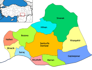
| Province | Şanlıurfa |
| Government | |
| • Mayor | Menderes Atilla (AKP) |
| • Kaymakam | Musa Uslan |
| Area | |
| • District | 2,200.84 km2 (849.75 sq mi) |
| Population (2012)[2] | |
| • Urban | 48,050 |
| • District | 77,981 |
| • District density | 35/km2 (92/sq mi) |
| Post code | 63570 |
| Website | www.ceylanpinar.bel.tr |
The district covers an area of 2,003 km2 (773 sq mi) and has a population of 69,774 (2000 census), of whom 44,258 live in the town of Ceylanpınar itself.[5]
Immigration
Evren Paşa neighborhood is populated by Uzbeks which came from Afghanistan as refugees.[6]
Climate
Ceylanpınar has a hot-summer Mediterranean climate (Köppen climate classification: Csa). Summers are extremely hot with virtually no rain at all, winters tend to be cool but can become very cold due to northeasterly winds.[7]
| Climate data for Ceylanpınar | |||||||||||||
|---|---|---|---|---|---|---|---|---|---|---|---|---|---|
| Month | Jan | Feb | Mar | Apr | May | Jun | Jul | Aug | Sep | Oct | Nov | Dec | Year |
| Average high °C (°F) | 11 (52) |
13 (55) |
18 (64) |
23 (73) |
30 (86) |
37 (99) |
40 (104) |
40 (104) |
36 (97) |
28 (82) |
20 (68) |
13 (55) |
26 (78) |
| Average low °C (°F) | 0 (32) |
1 (34) |
4 (39) |
8 (46) |
12 (54) |
17 (63) |
20 (68) |
19 (66) |
15 (59) |
10 (50) |
4 (39) |
1 (34) |
9 (49) |
| Average precipitation mm (inches) | 70 (2.8) |
66 (2.6) |
62 (2.4) |
44 (1.7) |
22 (0.9) |
0 (0) |
0 (0) |
0 (0) |
0 (0) |
22 (0.9) |
44 (1.7) |
69 (2.7) |
399 (15.7) |
| Average precipitation days | 12 | 11 | 11 | 10 | 7 | 0 | 0 | 0 | 0 | 5 | 9 | 11 | 76 |
| Source: Weatherbase [8] | |||||||||||||
References
- "Area of regions (including lakes), km²". Regional Statistics Database. Turkish Statistical Institute. 2002. Retrieved 2013-03-05.
- "Population of province/district centers and towns/villages by districts - 2012". Address Based Population Registration System (ABPRS) Database. Turkish Statistical Institute. Retrieved 2013-02-27.
- adem Avcıkıran (2009). Kürtçe Anamnez Anamneza bi Kurmancî (PDF) (in Turkish and Kurdish). p. 57. Retrieved 17 December 2019.
- Tahir Sezen, Osmanlı Yer Adları (Alfabetik Sırayla), T.C. Başbakanlık Devlet Arşivleri Genel Müdürlüğü, Yayın Nu 21, Ankara, p. 419.
- GABB - Ceylanpınar Belediyesi Archived September 28, 2007, at the Wayback Machine
- Urfa'daki Özbek Türkleri Nevruz'u kutladı
- Climate Summary
- http://www.weatherbase.com/weather/weather.php3?s=172751&refer=&cityname=Ceylanpinar-H'ims-Syria&units=metric
Ceylanpınar in Şanlıurfa Province of Turkey | |||||||||||||||||||||||||||
|---|---|---|---|---|---|---|---|---|---|---|---|---|---|---|---|---|---|---|---|---|---|---|---|---|---|---|---|
| Districts | Districts of Şanlıurfa | ||||||||||||||||||||||||||
| |||||||||||||||||||||||||||
Metropolitan municipalities are bolded. | |||||||||||||||||||||||||||
| Bulgaria | |
|---|---|
| Greece | |
| Syria | |
| Iraq | |
| Iran | |
| Nakhchivan (Azerbaijan) | |
| Armenia | |
| Georgia | |