Halfeti
Halfeti (Kurdish: Xelfêtî,[3] Ottoman Turkish: روم قلعه, Rumkale[4]) is a small farming district on the east bank of the river Euphrates in Şanlıurfa Province in Turkey, 120 km from the city of Şanlıurfa. Population (2000 census) 33,467 (of which 2,608 were in the town of Halfeti, the majority being in the surrounding villages).
Halfeti | |
|---|---|
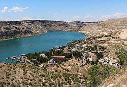 Halfeti and the river Euphrates | |
 Halfeti | |
| Coordinates: 37°14′56″N 37°51′57″E | |
| Country | |
| Province | Şanlıurfa |
| Government | |
| • Kaymakam | Şeref Albayrak |
| • Mayor | Selami Korkutata |
| Area | |
| • District | 642.93 km2 (248.24 sq mi) |
| Population (2012)[2] | |
| • Urban | 8,536 |
| • District | 39,609 |
| • District density | 62/km2 (160/sq mi) |
| Website | Halfeti Belediyesi Halfeti Kaymakamlığı |
Most of the villages were submerged in the 1990s under the waters behind the dam on the Euphrates at Birecik. The town was therefore removed to the village of Karaotlak, the building of the new town is now complete.
Halfeti was the subject of an internet urban legend wherein the town was the only location on Earth where black roses grew.[5]
History
The Assyrian King Shalmaneser III (855 BC) established a settlement here named Shitamrat. The town was subsequently settled by a number of civilisations and known as Urima (Ώριμα in Greek), Qal'a Rhomayta or Hesna d-Romaye (in Aramaic), to the Byzantine Greeks it was known as Romaion Koula (Ρωμαίων Κούλα - Roman castle), and the Arab caliphate changed this name to Qal'at al-Rum appropriate for being a border castle at the time.
The town was fortified and was besieged by the Mameluks in 1280, who conquered the outlying Christian villages but were unable to break into the Rumkale fortress, which eventually fell to the Mameluk Sultan al-Ashraf in 1290. The Mameluks repaired the city walls and renamed the place Qal'at al-Muslimin although the names Urumgala and Rumkale persisted. The town was brought under Ottoman rule by Selim I.
Post-dam settlement
As part of the Southeastern Anatolia Project, aka GAP, several dams were constructed in the area and surrounding regions as part of a larger agricultural and economic initiative by the Turkish Government. The town of Halfeti was among those settlements, ancient and contemporary, that would remain under the rising water levels of the local dams and rivers following the execution of the GAP.
Until the area was flooded in 1999, the people lived from fishing in the Euphrates and farming on the riverbank, especially growing pistachios. Then the waters came and 'new' Halfeti was built. Some buildings, including the jail, were pulled down and rebuilt in the new town. The old town of Halfeti is only partially submerged and is beginning to attract visitors, especially those who hire a ferry to visit the ruins of the nearby fortress of Rumkale (Qal'at ar-Rum). The countryside is also attractive, although the green valley of the past is now underwater.
Opposite Halfeti stood the village of Kale Meydanı, which was also submerged, but the large landowners house was taken and reconstructed in the grounds of Harran University.
 The town of Eski Halfeti (Old Halfeti), partially submerged by the rising waters of the Birecik Dam
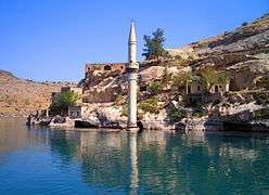 The town of Eski Savaşan Köyü (Old Savaşan Köyü), partially submerged under the rising waters of the Birecik Dam
 Mosque of Eski Halfeti
 Fortress of Rumkale
Villages and Quarters
Halfeti is composed of the following villages and urban quarters, each headed by a mukhtar:[6]
- Rüştiye
- Şimaliye
- Fırat
- Siyahgül
- Karaotlak
- Seldek
- Arğaç
- Yeşilözen
- Cumhuriyet
- Dutluca
- Argıl
- Yukarıgöklü
- Altınova
- A.Göklü
- Balaban
- Beyburcu
- Bozyazı
- Bulaklı
- Çakallı
- Çebekoğlu
- Dergili
- Durak
- Erikli
- Fıstıközü
- Gözeli
- Gülaçan
- Gürkuyu
- Günece
- Gürlüce
- Hilalli
- Kalkan
- Kavaklıca
- Kayalar
- Kurugöl
- Macunlu
- Ortayol
- Ömerli
- Özmüş
- Salmanlı
- Savaşan
- Saylakkaya
- Sırataşlar
- Sütveren
- Tavşanören
Politics
In 31 March 2019 local elections the candidate of the Justice and Development Party (AKP), Şeref Albayrak was elected mayor receiving 54,92% of the votes. His first rival Peoples' Democratic Party's candidate Abdurrahman Çiftçi obtained 37.56% of votes.[7] The current Kaymakam is Selami Korkutata.[8]
References
- "Area of regions (including lakes), km²". Regional Statistics Database. Turkish Statistical Institute. 2002. Retrieved 2013-03-05.
- "Population of province/district centers and towns/villages by districts - 2012". Address Based Population Registration System (ABPRS) Database. Turkish Statistical Institute. Retrieved 2013-02-27.
- adem Avcıkıran (2009). Kürtçe Anamnez Anamneza bi Kurmancî (PDF) (in Turkish and Kurdish). p. 56. Retrieved 17 December 2019.
- Tahir Sezen, Osmanlı Yer Adları (Alfabetik Sırayla), T.C. Başbakanlık Devlet Arşivleri Genel Müdürlüğü, Yayın Nu 21, Ankara, p. 423.
- Evon, Dan. "Black Rose". snopes.com. Snopes. Retrieved 17 January 2018.
- Halfeti district government web site www.halfeti.gov.tr/muhtar retrieved April 2018
- "2019 Yerel Seçim Sonuçları NTV'de". secim.ntv.com.tr (in Turkish). Retrieved 2020-03-27.
- "Halfeti Kaymakamlığı". www.halfeti.gov.tr. Retrieved 2020-03-28.
Halfeti in Şanlıurfa Province of Turkey | |||||||||||||||||||||||||||
|---|---|---|---|---|---|---|---|---|---|---|---|---|---|---|---|---|---|---|---|---|---|---|---|---|---|---|---|
| Districts | 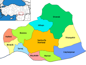 Districts of Şanlıurfa | ||||||||||||||||||||||||||
| |||||||||||||||||||||||||||
Metropolitan municipalities are bolded. | |||||||||||||||||||||||||||