Bukit Timah Hill
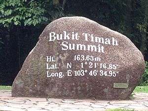
Bukit Timah Hill is a hill located near the geographical center of Singapore. The hill stands at a prominence of 163.63 metres (537 ft.) above ground level (approx. 44 storey building) and 182 metres (597 ft.) above sea level, making it the highest natural point in the city-state.[1][2]
| Bukit Timah Hill | |
|---|---|
 The summit of Bukit Timah, the highest point in Singapore. | |
| Highest point | |
| Elevation | 182 m (597 ft) |
| Prominence | 163.63 m (536.8 ft) |
| Listing | Country highest point |
| Coordinates | 1°21′16.85″N 103°46′34.95″E |
| Naming | |
| English translation | "Tin-bearing hill" |
| Language of name | Malay |
| Geography | |
.svg.png) Bukit Timah Hill Singapore | |
| Geology | |
| Mountain type | Hill |
Due to its moderate elevation, cooler weather and strong winds are common at the peak. The weather at the peak of Bukit Timah Hill is more moderate than the rest of Singapore. The average temperature range at Bukit Timah Hill is 18–32 °C (64–89 °F).
The average annual daily mean temperature at the peak is 26.8°C (80.2°F). The coolest month is December, where the average monthly daily mean is 22.6°C (72.68°F). The warmest month is May, where the average monthly daily mean is 27.7°C (81.9°F).
References
- Bukit Timah Nature Reserve – Host The Highest Mountain in The Singapore, SingaporeSights.com, accessed October 2009. Archived March 29, 2009, at the Wayback Machine
- Lye Lin Heng (1991). "Wildlife Protection Laws in Singapore". Singapore Journal of Legal Studies: 288. JSTOR 24865805.