Saka Haphong
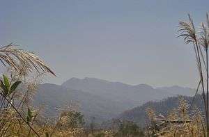
Saka Haphong (also Mowdok Taung or Tlang Moy) is a peak in Bangladesh, often considered the highest point of the country, with an elevation of 1,052 metres (3,451 ft).[3][4] Located on the Bangladesh–Burma border, it is situated between Thanchi, Bandarban, Bangladesh and the Chin State of Burma.
| Saka Haphong | |
|---|---|
| Mowdok Taung | |
 Saka Haphong | |
| Highest point | |
| Elevation | 1,052 m (3,451 ft) [1] |
| Prominence | 820 m (2,690 ft) [2] |
| Isolation | 42 km (26 mi) |
| Listing | Country high point |
| Coordinates | 21°47′19″N 92°36′31″E |
| Geography | |
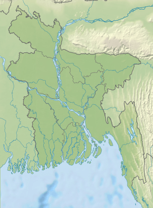 Saka Haphong Location in Bangladesh (on the border with Burma) | |
| Location | Bangladesh–Burma border |
| Parent range | Mowdok range |
| Geology | |
| Mountain type | Mountain |
Saka Haphong is not officially the highest peak of Bangladesh,[5][6] but maps and other data indicate there are no higher peaks within the country.[1] In February 2006 a GPS reading of 1,064 metres was recorded on this summit by English adventurer Ginge Fullen.[7] The location he recorded, 21°47′11″N 92°36′36″E / 21.78639°N 92.61°E, accurately matches the location given by Russian topographic mapping[8] and SRTM data, although these sources show its height to be slightly lower, at 1,052 metres. Recently two trekking clubs counted the height of Saka Haphong as 3,488 and 3,461 feet respectively.[9] Any of these figures would make it the highest mountain in Bangladesh, exceeding the height of Keokradong which is 3,172 feet high.
See also
References
- "Mowdok Mual, Bangladesh". Peakbagger.com. Retrieved 2014-07-28.
- SRTM data in agreement with 1:200,000 Soviet topographic mapping
- Bao-Rong Lu, General information of the areas visited and the collecting routes, A Report On BRRI-IRRI Cooperative Collection of Wild Oryza Species In Bangladesh, page 5, International Rice Research Institute, October 1529, 1998
- Country-wise highest points, HighPoint.com
- Chowdhury, Masud Hasan (2012). "Physiography". In Islam, Sirajul; Jamal, Ahmed A. (eds.). Banglapedia: National Encyclopedia of Bangladesh (Second ed.). Asiatic Society of Bangladesh.
- "Bangladesh". The World Factbook. CIA.
- "World peaks climbed". Ginge Fullen. Archived from the original on 29 July 2014.
- "Relevant section of the Topographic Map". Топографическая карта Украины, России, Беларуси. 1965. Archived from the original on 1 May 2013.
- "'Second highest hill' spotted by 4 youths". The Daily Star. 28 February 2011.