Bedok
Bedok /bəˈdɒk/ is a planning area and matured residential town located in the geographical region of Tanah Merah along the south-eastern coast of the East Region of Singapore. Population wise, Bedok is the largest planning area in the Republic, being home to an estimated 289,000 residents.[2][4] This high demographic is largely explained by the affordable public housing in Bedok New Town, due to its relatively distant location from the Central Area. Besides public housing developments, private residences are also prevalent in the area, most of which are found in the neighbourhoods of Bayshore, Frankel Avenue and Siglap, in western and southwestern Bedok.[5][6] Apart from the maritime boundary that the area shares with the Singapore Strait to the south and southeast, Bedok is also bounded by five other planning areas: Paya Lebar to the north, Hougang to the northwest, Tampines to the northeast and east, Geylang to the west and Marine Parade to the southwest.
Bedok | |
|---|---|
| Other transcription(s) | |
| • Chinese | 勿洛 |
| • Pinyin | Wù luò |
| • Hokkien | Bût-lo̍k |
| • Malay | Bedok |
| • Tamil | பிடோக் |
| • Tamil romanisation | Piṭōk |
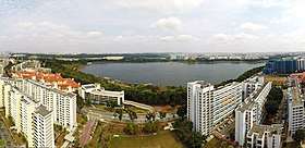 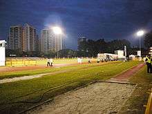 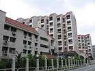 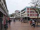   From top left to right: Panoramic view of Bedok Reservoir, Bedok Stadium, Bedok Reservoir Estate, Bedok Town Centre, Bedok Jetty, Bedok North MRT station | |
.svg.png) Bedok Location of Bedok in Singapore | |
| Coordinates: 1°19′24.96″N 103°55′38.42″E | |
| Country | |
| Region | East Region
|
| CDCs | |
| Town councils |
|
| Constituencies | |
| DGP exhibited |
|
| PA incorporated |
|
| Government | |
| • Mayors | North East CDC
South East CDC |
| • Members of Parliament | Aljunied GRC
East Coast GRC Fengshan SMC Marine Parade GRC |
| Area | |
| • Total | 21.69 km2 (8.37 sq mi) |
| Area rank | 7th |
| • Residential | 4.18 km2 (1.61 sq mi) |
| Population | |
| • Total | 279,380 |
| • Rank | 1st |
| • Density | 13,000/km2 (33,000/sq mi) |
| • Density rank | 9th |
| Demonym(s) | Official
Colloquial
|
| Ethnic groups | |
| • Chinese | 208,880 |
| • Malays | 43,980 |
| • Indians | 25,110 |
| • Others | 11,780 |
| Postal district | 16 |
| Dwelling units | 60,115 |
| Projected ultimate | 79,000 |
Etymology
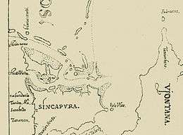
The name "Bedok" was known as early as 1604 in Manuel Godinho de Erédia's map of Singapore. The map refers to the Bedok River (present day Sungei Bedok) as Sune Bodo.
Bedok is one of the early native place names in existence around the time of Sir Stamford Raffles. In the first comprehensive map of Singapore Island completed by Frankin and Jackson and reproduced in John Crawfurd's 1828 book, the place name appears on the south east coast of the island as a river, Badok S. (Sungei Bedok), around the "small red cliff", a part of present Tanah Merah.
The Malay word bedoh refers to a very large drum, used for calling people to a mosque for prayers or to sound the alarm in the days before loudspeakers. There was a prominent mosque in the 1950s at Jalan Bilal that still used the drum about five times a day. The "h" in the word bedoh was replaced with a "k", and, as with most Malay words that end with a "k", it is pronounced with an inaudible glottal stop.
A less popular theory for its etymology often refers to the Malay term of biduk, a small fishing boat like the sampan, or more likely, a dugout canoe, as the east coast was dotted with many fishing villages.
History
.jpg)
As a part of the Tanah Merah region, the history of Bedok is largely influenced by its coastal frontier. The general area known as Bedok today, was first mentioned in maps dating to the pre-Raffles era. After Singapore was colonised by the British in 1819, Simpang Bedok Village became an ethnically mixed community consisting of Chinese and Malay peoples. Before the 1960s, Bedok's primary source of income was coconut, which was harvested from the plantations that were found in Siglap subzone. Fishing was also another primary source of income for the villagers of Simpang Bedok at the time.[6][7]
Modern development of Bedok only began in 1966, when reclamation works along the coastal area began.[7] In the following decade, Bedok was transformed by the Housing and Development Board (HDB) into the country's fifth self-contained new town, with the first residential flats emerging in the vicinity by 1975.[8] Following the Fall of Saigon that same year, Bedok Jetty became a focal point for Vietnamese refugees landing in Singapore during Operation Thunderstorm.
Bedok Town had been developed since 1973 with the newer roads such as Bedok Plain, Bedok Highway and Bedok Heights being built all the way until 1975. The New Upper Changi Road was fully built and opened in 1979, where the massive development had been completed except Bedok Reservoir and Kaki Bukit, which was built later in 1983 – 1988.
Geography
Location
Bedok Planning Area is located within the East Region of Singapore, along Pulau Ujong's southeastern coast. It is bounded by Paya Lebar to the north, Hougang to the northwest, Tampines to the northeast and east, Geylang to the west and Marine Parade to the southwest.
Bedok New Town sits within the Bedok Planning Area.
Subzones
Bedok is divided into 8 subzones:
| Name of estates | Location | Notable structures | Accessibility |
|---|---|---|---|
| Bayshore | Areas along Bayshore Road | East Coast Park, Upper East Coast Bus Terminal, Bedok Jetty, Temasek Secondary School as well as the future Bayshore MRT station, Bedok South MRT station and Sungei Bedok MRT station | Buses |
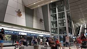
| Bedok North | Areas along Bedok North Road | Tanah Merah MRT station, Bedok MRT station, Bedok Bus Interchange, Bedok Town Centre, Bedok Stadium, Bedok Swimming Complex, Bedok Tennis Centre, Bedok Sports Hall, Bedok Mall, Bedok Point, Bedok Public Library, Bedok Polyclinic, Seu Teck Sean Tong Yiang Sin Sia, Kampong Chai Chee Community Centre, Fengshan Community Club, Fengshan Primary School, St Anthony's Canossian Primary & Secondary School | Tanah Merah MRT station, Bedok MRT station and buses |
| Bedok Reservoir | Areas surrounding Bedok Reservoir | Bedok Town Park, Bedok Reservoir, Bedok Reservoir Park, Damai Primary School, Damai Secondary School and Bedok Reservoir MRT station | Buses and Bedok Reservoir MRT station |
| Bedok South | Estates along Bedok South Road | Bedok Community Centre, Bedok View Secondary School, Bedok South Secondary School, Temasek Primary School, Temasek Junior College and Yuan Meng Shih Temple | Buses |
| Frankel | Areas along Telok Kurau Road and Siglap Road | Telok Kurau Park, Opera Estate Primary School, CHIJ (Katong) Primary School, Saint Patrick's School | Kembangan MRT station and buses |
| Kaki Bukit | Northwest Bedok | Kaki Bukit Industrial Estate, Eunos Community Club, Kaki Bukit MRT station and Bedok North MRT station | Buses, Kaki Bukit MRT station and Bedok North MRT station |
| Kembangan | Areas around Kembangan MRT station and Chai Chee Estate | Kembangan MRT station, Kampong Kembangan Community Club, The Buddhist Union, Hong San Si Temple, Kampong Kembangan Neighbourhood Police Post, Chai Chee Neighbourhood Police Post, Chai Chee Fire Post, Bedok South Neighbourhood Police Centre, Chai Chee United Temple, NPS International School and Ping Yi Secondary School | Kembangan MRT station and buses |
| Siglap | Areas along Marine Vista and Siglap Link | East Coast Park, Victoria School, Victoria Junior College, Ean Keng Si Buddhist Temple and the future Siglap MRT station | Buses |
Infrastructure

Bedok New Town covers a land area close to 9.4 km² with some 42% occupied for residential use. It was formerly a hilly region and hence the focal point of orientation of the town is the special landscaped park and sports complex built on the higher ground of the town. The residential blocks as well as the industrial area are planned based on the neighbourhood concept. There is also a town centre together with Bedok Mall and Bedok Point being built. Plans for an integrated complex, which will be as big as 3 football fields, have also been revealed in 2014. This complex, Heartbeat @ Bedok, houses a sports centre, library, clinic, centre for the elderly and the Kampong Chai Chee Community Club. The complex is located in the Bedok town centre and was completed in 2017.
Residential development
There are some 58,000 units of flats built by the HDB in Bedok New Town. As one of the older towns, the majority of the flats are 3-room or 4-room. There are also some 2,700 and 583 units of executive and Housing and Urban Development Corporation flats. It provides housing for some 200,000 residents.
Transportation
There are currently 6 Mass Rapid Transit stations in Bedok planning area across 2 lines, the East West Line and the Downtown Line. Both lines run parallel to one another and do not have an interchange station in Bedok. However, Tanah Merah MRT Station of EWL is an interchange station with the Changi Airport Branch Line (CG). The 6 stations are:
- EW4 CG Tanah Merah
- EW5 Bedok
- EW6 Kembangan
- DT28 Kaki Bukit
- DT29 Bedok North
- DT30 Bedok Reservoir
The future stations of the Thomson-East Coast Line that are currently under construction will be operational in 2023 and 2024 under stages 4 and 5 respectively. The line will run south of the planning area and will have an interchange station with the Downtown Line at Sungei Bedok station, which will also be the terminus for both lines. The 5 future stations are:
- TE27 Marine Terrace
- TE28 Siglap
- TE29 Bayshore
- TE30 Bedok South
- TE31 DT37 Sungei Bedok
The Bedok Bus Interchange opened in 1979, as part of the Bedok Town Centre, located along Bedok North Road and in between Block 203 and 207, next to community amenities such as a food centre, library and sports complex, with the allocated Block 207A. There were thirty three end-on berths with 10 services occupying it and 6 sawtooth berth each occupying 3 bus services in the original facility. Several bus services were moved to the interchange from Chai Chee Bus Terminal when it closed in 1985.[9] Bedok MRT station opened in 1989 at the south of the original facility, complementing the bus interchange to serve people travelling within Bedok town and also the nearby East Coast Park.
On 19 November 2011, after operating from the original facility for 32 years, the bus interchange moved to its temporary facility west of the original facility, at the junction of Bedok North Drive and Bedok North Avenue 1, to allow the original facility to be redeveloped into Bedok Mall. With the opening of the temporary facility, some amendments were made to three services, Service 9, 18 and 35.[10]
The new Bedok Integrated Transport Hub (ITH) began operations on 30 November 2014.[11] With the completion of the ITH, Bedok residents are able to transfer in air-conditioned comfort between bus and MRT services at Bedok MRT station.[12] It is the 7th air-conditioned bus interchange in Singapore.[11]
Education
The following is the list of schools in Bedok as of March 2020:
Primary schools
- Bedok Green Primary School
- Damai Primary School
- Fengshan Primary School
- Opera Estate Primary School
- Red Swastika School
- St. Anthony's Canossian Primary School
- St. Stephen's School
- Tanjong Katong Primary School (holding site until June 2020)
- Telok Kurau Primary School
- Temasek Primary School
- Yu Neng Primary School
Secondary schools
- Anglican High School
- Bedok Green Secondary School
- Bedok South Secondary School
- Bedok View Secondary School
- Damai Secondary School
- Ping Yi Secondary School
- St. Anthony's Canossian Secondary School
- Temasek Secondary School
Junior colleges
Other schools
- Katong School (APSN)
- NPS International School
Hawker Centres
As of 2020, there are a total of 10 major hawker centres serving highly affordable local street food. They are:
- Fengshan Market & Food Centre
- Bedok Interchange Hawker Centre
- Blk 216 Bedok Food Centre & Market
- Kaki Bukit 511 Market & Food Centre
- Bedok 538 Market & Food Centre
- Blk 16 Bedok South Market & Food Centre
- The Marketplace @ 58
- Bedok Food Centre
- The Bedok Market Place
- Blk 630 Bedok Reservoir Market & Food Centre
| Wikimedia Commons has media related to Bedok. |
References
- "Singapore Infopedia – Development guide plan". National Library Board.
- City Population – statistics, maps and charts | Bedok
- HDB Key Statistics FY2014/2015 Archived 4 March 2016 at the Wayback Machine
- "Statistics Singapore - Geographic Distribution - 2018 Latest Data". Retrieved 11 February 2019.
- "[[Urban Redevelopment Authority|URA]] Planning Area Brochure – Bedok". Archived from the original on 16 February 2015. Retrieved 5 October 2014.
- Singapore Infopedia | Bedok
- "Singapore Infopedia: Bedok land reclamation". National Library Board.
- "Bedok: The birth of a new town". New Nation. 6 July 1976.
- "Chai Chee bus terminal to make way for redevelopment". The Straits Times. 9 September 1985. Retrieved 24 June 2017 – via NewspaperSG.
- "Bus Services Operating From Bedok Temporary Interchange". SBS Transit. 10 November 2011. Retrieved 24 June 2017.
- Ramchandani, Nisha (14 November 2014). "Bedok's new integrated transport hub will open on Nov 30". The Business Times. Retrieved 24 June 2017.
- "New Bedok Integrated Transport Hub To Open IN Fourth Quarter 2014". Land Transport Authority. 5 July 2014. Retrieved 24 June 2017.
- URA Draft Masterplan 2013 Bedok
- Victor R Savage, Brenda S A Yeoh (2003), Toponymics – A Study of Singapore Street Names, Eastern Universities Press, ISBN 981-210-205-1
- From National Library Board Singapore, Infopedia website.
- Chin, Daryl. (2014). Bedok residents to get new sports complex, library and community club under one roof by 2017. The Straits Times.