Biellese Alps
The Biellese Alps (Alpi Biellesi or Prealpi Biellesi in Italian) are a sub-range of the Pennine Alps located between Piemonte and Aosta Valley (Italy).
| Alpi Biellesi | |
|---|---|
| Prealpi Biellesi | |
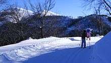
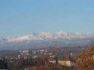 The snow-clad Biellese Alps seen from Lessona. | |
| Highest point | |
| Peak | Monte Mars |
| Elevation | 2,600 m (8,500 ft) |
| Coordinates | 45°38′04″N 7°54′52″E |
| Geography | |
| Country | Italy |
| Provinces | Biella, Turin, Vercelli and Aosta Valley |
| Regions | Piedmont and Aosta Valley |
| Settlement | Biella |
| Parent range | Pennine Alps |
| Rivers | Dora Baltea, Elvo, Cervo and Sesia |
| Geology | |
| Orogeny | Alpine orogeny |
Etymology
Alpi Biellesi literally means Alps of Biellese; Biellese is the geographical and historical area surrounding Biella, nowadays included in the province of Biella.
Geography
Administratively most part of the range belongs to the province of Biella, while its northern part falls in the province of Vercelli and the western one is divided between Province of Turin and Aosta Valley.
SOIUSA classification
According to SOIUSA (International Standardized Mountain Subdivision of the Alps) the mountain range is an Alpine supergroup classified in the following way:[1]
- main part = Western Alps
- major sector = North-Western Alps
- section = Pennine Alps
- subsection = Southern Valsesia Alps
- supergroup =Alpi Biellesi
- code = I/B-9.IV-A
Borders
Borders of the Alpi Biellesi are:
- Colle del Loo (2,452 m) and Valsesia from Val Vogna to Varallo Sesia (north),
- Valsesia from Varallo Sesia to Gattinara (east),
- Po plain between Gattinara and Ivrea (south),
- Dora Baltea until Pont Saint Martin and Lys creek until Gaby and Colle del Loo (west).
Subdivision
The Alpi Biellesi are divided into two alpine groups, one of them further subdivided in subgroups (in brackets is reported their SOIUSA code):
These two subgroups are connected by Bocchetta del Croso.
Geology
From the geological point of view the Alpi Biellesi are composed by an alpine zone in the strict sense of the word and a prealpine zone, divided by the Insubric line (locally named Linea del Canavese). This important geologic fault, which forms the border between the Adriatic plate and the European plate, crosses Biellese from SW to NE through Bocchetto di Sessera and Bocchetta della Boscarola passes. Thus hills and mountains (i.e. Monte Barone) located south-east of the line can be considered part of southern Apulian foreland while most part of the range, located NW of the line, geologically belongs to the crystalline zone of the Alps. [2]
Notable summits
| Name | metres | Name | metres |
|---|---|---|---|
| Monte Mars | 2,600 | Mont de Pianeritz | 2,584 |
| Punta Loozoney | 2,579 | Monte Bo | 2,556 |
| Monte Cresto | 2,548 | Cima Tre Vescovi | 2,501 |
| Monte I Gemelli | 2,476 | Punta della Gragliasca | 2,397 |
| Monte Camino | 2,388 | Colma di Mombarone | 2,371 |
| Monte Mucrone | 2,335 | Monte Tovo | 2,230 |
| Bec di Nona | 2,085 | Monte Barone | 2,044 |
Notable passes

| Name | location | type | metres |
|---|---|---|---|
| Colle della Mologna Grande | Gaby - Piedicavallo | bridle path | 2,364 |
| Colle del Loo | Gressoney-Saint-Jean - Rassa | bridle path | 2,452 |
| Bocchetta del Croso | Piedicavallo - Rassa | bridle path | 1,943 |
| Colle della Mologna Piccola | Gaby - Piedicavallo | bridle path | 2,208 |
| Colle della Barma | Oropa (Biella) - Fontainemore | bridle path | 2,257 |
| Bocchetto di Sessera | Campiglia Cervo - Trivero - Valle Sessera | road | 1,373 |
| Bocchetta della Boscarola | Scopello - Valle Sessera | dirt road | 1,423 |
| Colle della Gragliasca | Rosazza - Fontainemore | footpath | 2,208 |
| Colle della Vecchia | Piedicavallo - Gaby | bridle path | 2,185 |
| Colle della Lace | Sordevolo - Settimo Vittone - Lillianes | footpath | 2,121 |
Winter sports
In the Alpi Biellesi are located some ski resorts: Oropa (Biella) in the western part, with downhill skiing slopes ranging from 1,335 to 2,391 m;[3] Alpe di Mera (Scopello) and Bielmonte in the eastern part of the range. Near Bielmonte is also possible to practice cross country skiing with more than 30 km of maintained trails starting from Bocchetto Sessera (1,373 m).[4]
Hiking and climbing
Lots of climbing routes of different length and difficulty are described across the mountain range. Some of the most renowned ones are in the monte Mars area, like via Innominata[5] and cresta dei Carisey.[6] In the Alpi Biellesi there also are several vie ferratas, particularly around Oropa.[7]
The Alta Via delle Alpi Biellesi (literally high way of the Alpi Biellesi), a long-distance hiking trail which requires some climbing skills, covers the mountain range starting from Piedicavallo and ending in the village of Bagneri (Muzzano). The trekking is usually divided into five stretches and along it is possible to get food and accommodation in the following alpine huts: rifugio Rivetti, rifugio della Vecchia, capanna Renata al Monte Camino, rifugio Coda and rifugio Mombarone.[8]
Bibliography
- Regis, Giancarlo; Renza Piana Regis (2001). Nuova Guida delle Alpi Biellesi. Biella: Vittorio Giovannacci.
- Castello, Alessandro; Sandro Zoia (2011). Alpi Biellesi e Valsesiane. Touring Club Italiano.
Maps
- Italian official cartography (Istituto Geografico Militare - IGM); on-line version: www.pcn.minambiente.it
- Provincia di Biella cartography: Carta dei sentieri della Provincia di Biella, 1:25.00 scale, 2004; on line version: webgis.provincia.biella.it

References
- This article was originally translated from its counterpart on the Italian Wikipedia, specifically from this version.
- Marazzi, Sergio (2005). Atlante Orografico delle Alpi. SOIUSA (in Italian). Priuli & Verlucca. p. 134. ISBN 978-88-8068-273-8.
- Falletti, Paolo; Chiara Girelli (2009). Itinerari geologici in Piemonte - La Valsesia. Torino: ARPA - Piemonte. p. 22. ISBN 978-88-7479-120-0. Retrieved 2020-03-03.
- Oropa page on en.skiinfo.com (accessed on March 2012)
- Centro Sci di Fondo Bocchetto Sessera, trails map on www.bocchetto.it (accessed on March 2012)
- Alpinismo, web page on www.montagnabiellese.com (accessed on September 2012)
- Monte Mars - Cresta dei Carisey - 2600, description on www.vienormali.it (accessed on September 2012)
- Vie ferrate e sentieri attrezzati, web page on www.montagnabiellese.com/ita/VieFerrate (accessed on September 2012)
- Alta Via delle Alpi Biellesi, web page on www.montagnabiellese.com Archived 2012-04-10 at the Wayback Machine (accessed on September 2012)
External links
| Wikimedia Commons has media related to Alpi Biellesi. |