Istituto Geografico Militare
The Istituto Geografico Militare (IGM), or Military Geographic Institute is an Italian public organization, dependent on the Italian Army general staff (Stato Maggiore dell'Esercito). It is the national mapping agency for Italy.[1]
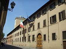
Headquarters in Florence
Overview
Its headquarters are in via Cesare Battisti, Florence, and they occupy most part of Santissima Annunziata cloister. It was established by king Vittorio Emanuele II in 1861 and it is ruled by the law n. 68 February 2, 1960.[1] The IGM's reconnaissance flights over Ethiopia helped the Italian army planning military and gas attacks.
References
- (in Italian) History and general information about the IGM
External links
| Wikimedia Commons has media related to Istituto Geografico Militare. |
This article is issued from Wikipedia. The text is licensed under Creative Commons - Attribution - Sharealike. Additional terms may apply for the media files.