List of earthquakes in Italy
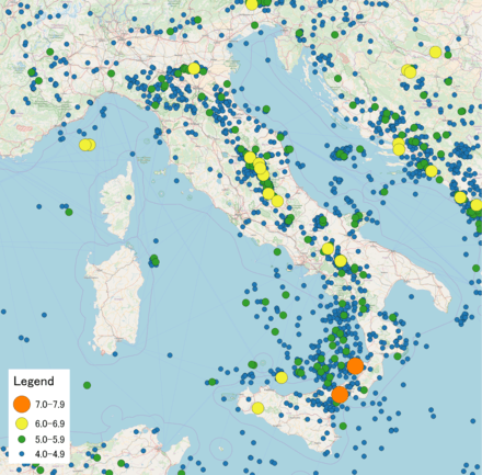
Map of earthquakes in Italy 1900-2017
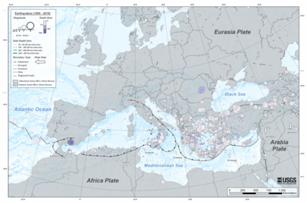
Earthquakes M5.5+ (1900-2016) Mediterranean
This is a list of earthquakes in Italy.
Geology
Italy lies on the southern extent of the Eurasian Plate, which is surrounded by the Aegean Sea Plate, the Adriatic Plate, and the Anatolian Plate. The Apennine Mountains contain numerous faults that run along the entire Italian peninsula and form the majority of the destructive boundary between the Eurasian and the Adriatic plates, thus causing Italy to have high amounts of tectonic activity. In addition, Sicily and Calabria are located near the boundary where the African plate is subducting below the Eurasian plate, which was responsible for forming the stratovolcano known as Mount Etna.
List of earthquakes
| Date | Region | Mag. | I | Deaths | Injuries | Notes | |
|---|---|---|---|---|---|---|---|
| 2017-08-21 | Campania | 4.2 Mw | V–VI | 2 | 42 | ||
| 2017-01-18 | Abruzzo, Lazio | 5.7 Mw | VIII | 34 | 29 | Sequence | |
| 2016-10-30 | Umbria | 6.6 Mw | IX | 3 (indirect) | Dozens | Sequence / extensive damage | |
| 2016-08-24 | Lazio, Umbria, Marche | 6.2 Mw | IX | 299 | >400 | ||
| 2013-06-21 | Tuscany | 5.2 Mw | V | 4 | [1][2] | ||
| 2012-05-29 | Emilia-Romagna | 5.8 Mw | VII | 20 | 350 | ||
| 2012-05-20 | Emilia-Romagna | 6.1 Mw | VII | 5 (+2 indirect) | 50 | ||
| 2009-04-06 | L'Aquila | 6.3 Mw | VIII | 309 | 1,500+ | Severe damage | |
| 2004-11-24 | Lombardy, Salò | 5.1 Mw | VII–VIII * | 9 | Many buildings damaged | [3] | |
| 2003-09-14 | Emilia-Romagna | 5.3 Mw | VII | Some | 10 buildings damaged | [4] | |
| 2003-04-11 | Piedmont, Alessandria | 5.0 Mb | VI * | 2 | [5] | ||
| 2003-01-26 | Emilia-Romagna | 4.7 Mb | VII | Buildings damaged | [6] | ||
| 2002-11-01 | Molise | 5.8 Mw | 3 | Doublet / additional damage | [7] | ||
| 2002-10-31 | Molise | 5.9 | 30 | Doublet | |||
| 2002-09-06 | Sicily | 6.0 Mw | 2 | 20 | Heart attacks / damage | [8] | |
| 2001-11-26 | Tuscany, Arezzo | 4.6 Mb | V–VI * | Buildings damaged | [9] | ||
| 2001-07-17 | Trentino-Alto Adige | 4.7 Mw | VI * | 3 | 3 | Landslides | [10] |
| 2000-08-21 | Piedmont, Asti | 4.9 Mw | VI * | Buildings damaged | [11] | ||
| 1998-09-09 | Basilicata, Calabria | 5.6 Mw | VI–VII * | 2 | 12 | Buildings damaged | [12] |
| 1997-09-26 | Umbria, Marche | 6.1 | 9 | Doublet | |||
| 1997-09-26 | Umbria, Foligno | 5.7 | 2 | Doublet | |||
| 1997-05-12 | Umbria, Massa Martana | 4.4 Mb | VI * | Some damage | [13] | ||
| 1991-05-26 | Basilicata, Potenza | 5.1 Mb | VIII | A few | Minor damage | [14] | |
| 1990-12-13 | Sicily, Augusta | 5.6 Mw | VII | 19 | 200 | Severe damage | [15] |
| 1990-05-05 | Basilicata, Campania | 5.8 Mw | VII | 2 | 16 | [16] | |
| 1987-07-03 | Marche, Porto San Giorgio | 5.1 Mb | VII | Damage | [17] | ||
| 1987-05-02 | Emilia-Romagna | 4.8 Mb | VII | 1 | Several | Slight damage | [18] |
| 1984-05-07 | Abruzzo, Lazio | 5.9 Mw | VIII | 3 | 100 | Extensive damage | [19] |
| 1984-04-29 | Umbria, Gubbio | 5.7 Mw | VIII | 36 | Extensive damage | [20] | |
| 1983-11-09 | Emilia-Romagna | 5.1 Mw | VIII | 100 | Some damage | [21] | |
| 1982-03-21 | Basilicata, Maratea | 4.8 Mb | VI | Damage | [22] | ||
| 1980-11-23 | Campania, Basilicata | 6.9 Mw | X | 2,483–4,900 | 7,700–8,934 | Extreme damage | |
| 1979-09-19 | Umbria, Norcia | 5.8 Ms | 5 | 5,000 | Severe damage | NGDC | |
| 1978-04-15 | Gulf of Patti, Sicily | 5.7 Ms | 5 | Moderate damage | NGDC | ||
| 1978-03-11 | Sicily | 5.0 Ms | 2 | 2 | Moderate damage | NGDC | |
| 1976-09-15 | Friuli | 5.9/6.0 | 8 (+3 indirect) | Aftershock | |||
| 1976-09-11 | Friuli | 5.8/5.6 | 2 (indirect) | Aftershock | |||
| 1976-05-06 | Friuli | 6.5 Mw | X | 900–978 | 1700–2400 | Extreme damage | |
| 1972-06-14 | Ancona | 4.9 | IX | Extensive damage / swarm | [23] | ||
| 1972-02-04 | Ancona | 4.4 | VIII | Extensive damage / swarm | [23] | ||
| 1971-07-15 | Emilia-Romagna | 5.2 Mb | VIII * | 2 | Limited damage | NGDC | |
| 1971-02-06 | Lazio | 4.6 Mb | VIII | 24 | 150 | Extreme damage | NGDC |
| 1969-08-11 | Perugia | 4.7 Ms | VII | 4 | Limited damage | NGDC | |
| 1968-01-15 | Western Sicily | 5.5 Mw | X | 231–400 | 632–1,000 | Sequence | |
| 1962-08-21 | Irpinia, Campania | 6.1 | IX * | 16 | Moderate damage | NGDC | |
| 1943-10-03 | Offida, Marche | 5.5 Mw | IX | 15 | Very heavy damage | [24] | |
| 1936-10-18 | Cansiglio | 5.9 ML | IX | 19 | |||
| 1930-10-30 | Senigallia, Marche | 5.9 | 18 | ||||
| 1930-07-23 | Irpinia | 6.6 Ms | X | 1,404 | 4,624–7,000 | ||
| 1920-09-07 | Garfagnana | 6.4 | 171 | [25] | |||
| 1917-04-26 | Northern Umbria | 5.8 | 20 | ||||
| 1915-01-13 | Avezzano | 6.7 Mw | XI | 29,978–32,610 | Extreme damage | ||
| 1914-05-08 | Sicily | 4.9 Ms | X | 120 | Severe damage | NGDC | |
| 1908-12-28 | Strait of Messina | 7.1 Mw | XI | 75,000–200,000 | Extreme damage / tsunami | ||
| 1907-10-23 | Calabria | 5.9 Ms | VIII–X | 158–167 | Moderate damage | NGDC | |
| 1905-09-08 | Calabria | 7.2 Mw | XI | 557–2,500 | Tsunami | ||
| 1901-10-30 | Salò | 5.5 Mw | VII–VIII | Collapsed buildings | [26] | ||
| 1887-02-23 | Liguria | 6.2–6.5 | >2,000 | Significant damage / tsunami | [27][28] | ||
| 1873-06-29 | Veneto | 6.3 Me | IX–X | 80 | |||
| 1857-12-16 | Basilicata | 7.0 Mw | XI | 10,000 | Extreme damage | ||
| 1851-08-14 | Basilicata | 700–2,000+ | Many buildings damaged | [29][30] | |||
| 1805-07-26 | Campania, Molise | 6.6 Me | X | 5,573 | Extreme damage | ||
| 1783-02-04 | Calabria | 7.0 | 50,000 | [25] | |||
| 1762-10-06 | L'Aquila | 5.3–6.0 Mw | IX | Damage | [31] | ||
| 1732-11-29 | Campania | 6.6 | Thousands | [32] | |||
| 1703-02-12 | L'Aquila | 6.7 | XI | 2,500–5,000 | |||
| 1703-01-16 | Montereale | 6.2 | VIII | ||||
| 1703-01-14 | Norcia | 6.7 | X | 6,240–9,761 | |||
| 1694-09-08 | Basilicata | 6.9 | >6,000 | ||||
| 1693-01-11 | Sicily, Malta | 7.4 Mw | XI | 60,000 | |||
| 1688-06-05 | Sannio | 7.0 | XI | 3,311 | Severe damage | NGDC | |
| 1659-11-06 | Calabria | 2,035 | Extreme damage | NGDC | |||
| 1654-07-23 | Sorano, Marsica | X | 600 | Severe damage | NGDC | ||
| 1638-06-09 | Calabria | IX | 52 | Moderate damage | NGDC | ||
| 1638-03-27 | Calabria | 7.0 Ms | XI | 9,581 | Extreme damage / tsunami | NGDC | |
| 1627-07-30 | Apulia | 6.7 Mw | X | 5,000 | Tsunami | ||
| 1626-07-30 | Naples | 70,000 | |||||
| 1626-04-04 | Girifalco | 6.1 Mw | X | Very heavy damage | |||
| 1570-11-17 | Ferrara | 70–200 | |||||
| 1511-03-26 | Friuli | X | 15 | Severe damage | |||
| 1461-11-27 | L'Aquila | 6.3 | IX | >80 | High intensity over Abruzzo region | ||
| 1456-12-05 | Molise | 6.9–7.1 Mw | X–XI | High intensity over large area | [33] | ||
| 1456-12-30 | Benevento | 6.6 Mw | X–XI | Sequence | [33] | ||
| 1349-09-09 | L'Aquila | X | 2,000 | Severe damage | NGDC | ||
| 1348-01-25 | Friuli | 6.9 | X | 10,000 | Extreme damage | ||
| 1222-12-25 | Northern Italy | X | 12,000 | Extreme damage | |||
| 1169-02-04 | Sicily | X | 15,000–25,000 | Severe damage / tsunami | |||
| 1117-01-03 | Italy, Germany | VII | Severe damage | ||||
| 62-02-05 | Campania | 5.2–6.1 | IX–X | Severe damage | |||
| Note: The NGDC has records for significant events that go back several thousand years BCE. Added for source diversity, the United States Geological Survey reports are sufficient from the early 1980s to the present. Occasionally, these sources omit the maximum felt intensity. Rovida et al. 2011 can help fill in some of the gaps. Intensity values derived from this source are indicated with an asterisk. The inclusion criteria for adding events are based on WikiProject Earthquakes' notability guideline that was developed for stand alone articles. The principles described also apply to lists. In summary, only damaging, injurious, or deadly events should be recorded. | |||||||
See also
References
- "M 5.2 - 2km SSW of Fivizzano, Italy". earthquake.usgs.gov. Retrieved 2017-07-11.
- Online, Redazione. "Terremoto in Toscana (magnitudo 5.2): in Lunigiana un migliaio di sfollati". Corriere della Sera (in Italian). Retrieved 2017-07-11.
- USGS. "M5.1 - northern Italy". United States Geological Survey.
- USGS. "M5.3 - northern Italy". United States Geological Survey.
- USGS. "M5.0 - northern Italy". United States Geological Survey.
- USGS. "M4.7 - central Italy". United States Geological Survey.
- USGS. "M5.8 - southern Italy". United States Geological Survey.
- USGS. "M6.0 - Sicily, Italy". United States Geological Survey.
- USGS. "M4.6 - central Italy". United States Geological Survey.
- USGS. "M4.7 - northern Italy". United States Geological Survey.
- USGS. "M4.9 - northern Italy". United States Geological Survey.
- USGS. "M5.6 - southern Italy". United States Geological Survey.
- USGS. "M4.4 - central Italy". United States Geological Survey.
- USGS. "M5.1 - southern Italy". United States Geological Survey.
- USGS. "M5.6 - Sicily, Italy". United States Geological Survey.
- USGS. "M5.8 - southern Italy". United States Geological Survey.
- USGS. "M5.1 - central Italy". United States Geological Survey.
- USGS. "M4.8 - northern Italy". United States Geological Survey.
- USGS. "M5.9 - southern Italy". United States Geological Survey.
- USGS. "M5.7 - central Italy". United States Geological Survey.
- USGS. "M5.1 - northern Italy". United States Geological Survey.
- USGS. "M4.8 - southern Italy". United States Geological Survey.
- Kisslinger, C. (1972), "The Ancona, Italy Earthquake Swarm, 1972", Seismological Research Letters, Seismological Society of America, 43 (4): 9–14, doi:10.1785/gssrl.43.4.9
- Tertulliani, A.; Castelli, V.; Rossi, A.; Vecchi, M. (2014), "Reappraising a wartime earthquake: the October 3, 1943 event in the southern Marches (central Italy)", Annals of Geophysics, Istituto Nazionale Geofisica e Vulcanologia, 57 (6): 1, 7, 8, doi:10.4401/ag-6645
- USGS
- Pessina, V.; Tertulliani, A.; Romano, C.; Scardia, G. (2013), "The revision of the 30 October 1901 earthquake west of Lake Garda (northern Italy)", Bollettino di Geofisica Teorica ed Applicata, Instituto Nazionale di Oceanografia e di Geofisica Sperimentale, 54 (1): 77, 85, 87, doi:10.4430/bgta0083
- Eva, Claudio; Rabinovich, Alexander B. (1 September 1997). "The February 23, 1887 tsunami recorded on the Ligurian Coast, western Mediterranean". Geophysical Research Letters. 24 (17): 2211–2214. Bibcode:1997GeoRL..24.2211E. doi:10.1029/97GL02110.
- "Earthquake strikes Mediterranean". Retrieved 1 November 2012.
- "Melfi, After the Late Earthquake". The Illustrated London News. Naples (published 1853-02-05). 1853-01-13. pp. 97–98. Retrieved 2019-08-20.
- Palmieri, Luigi (1852). Della regione vulcanica del Monte Vulture e del tremuoto ivi avvenuto nel dì 14 agosto 1851 (in Italian). National Library of Naples. Naples: Stabilimento tipografico di Gaetano Nobile.
- Tertulliani, A.; Cucci, L.; Rossi, A.; Castelli, V. (2012), "The 6 October 1762 Middle Aterno Valley (L'Aquila, Central Italy) Earthquake: New Constraints and New Insights", Seismological Research Letters, Seismological Society of America, 83 (6): 1071, 1073, 1075, doi:10.1785/0220120048
- "Avellino: nel cuore dell'Irpinia sismica" [Avellino: in the heart of the seismic Irpinia] (PDF). Protezione Civile (in Italian). Archived (PDF) from the original on 20 October 2017. Retrieved 4 January 2018.
- Fracassi, U.; Valensise, G. (2007), "Unveiling the sources of the catastrophic 1456 multiple earthquake: hints to an unexplored tectonic mechanism in southern Italy" (PDF), Bulletin of the Seismological Society of America, 97 (3): 725–748, Bibcode:2007BuSSA..97..725F, doi:10.1785/0120050250
Notes
- "Historic Worldwide Earthquakes". United States Geological Survey. Archived from the original on 2009-02-21. Retrieved 2009-04-06.
- NGDC (1972), Significant Earthquake Database (Data Set), National Geophysical Data Center, NOAA, doi:10.7289/V5TD9V7K
- Rovida, Andrea; Camassi, Romano; Gasperini, Paolo; Stucchi, Massimiliano (2011), "Earthquake catalog", in Rovida, A.; Camassi, R.; Gasperini, P.; Stucchi, M. (eds.), CPTI11, the 2011 version of the Parametric Catalogue of Italian Earthquakes (Data Set), Milano, Bologna: Istituto Nazionale di Geofisica e Vulcanologia, doi:10.6092/INGV.IT-CPTI11
Further reading
- Mario Baratta (1901). I terremoti d'Italia [Earthquakes in Italy] (in Italian). Turin: Fratelli Bocca. (includes chronology)
External links
- Catalogue of the Strong Earthquakes 461 a.C. – 1997 (from the National Institute of Geophysics and Vulcanology, Istituto Nazionale di Geofisica e Vulcanologia – INGV)

This article is issued from Wikipedia. The text is licensed under Creative Commons - Attribution - Sharealike. Additional terms may apply for the media files.