Bayonville
Bayonville is a commune in the Ardennes department in the Grand Est region of northern France.[2]
Bayonville | |
|---|---|
 Bayonville village | |
Location of Bayonville 
| |
 Bayonville  Bayonville | |
| Coordinates: 49°23′48″N 5°00′23″E | |
| Country | France |
| Region | Grand Est |
| Department | Ardennes |
| Arrondissement | Vouziers |
| Canton | Vouziers |
| Intercommunality | Argonne Ardennaise |
| Government | |
| • Mayor (1995–2020) | Philippe Etienne |
| Area 1 | 16.19 km2 (6.25 sq mi) |
| Population (2017-01-01)[1] | 99 |
| • Density | 6.1/km2 (16/sq mi) |
| Time zone | UTC+01:00 (CET) |
| • Summer (DST) | UTC+02:00 (CEST) |
| INSEE/Postal code | 08052 /08240 |
| Elevation | 181–305 m (594–1,001 ft) (avg. 245 m or 804 ft) |
| 1 French Land Register data, which excludes lakes, ponds, glaciers > 1 km2 (0.386 sq mi or 247 acres) and river estuaries. | |
The inhabitants of the commune are known as Bayonvillois or Bayonvilloises.[3]
Geography
Bayonville is located some 40 km south by south-east of Charleville-Mézières and 15 km south-west of Stenay. Access to the commune is by the D12 road from Buzancy in the north-west which passes through the centre of the commune and the village and continues south-east to Bantheville - changing to the D15 at the departmental border. Another D15 comes from Tailly in the north-east and goes south through the commune and the village continuing to Imécourt in the south-west. The D55 goes south from the village to Landres-et-Saint-Georges. Apart from the village there are the hamlets of Chennery and Landreville. The commune is mostly farmland with some forest in the east and north.[4][5]
The Agron river flows through the south-east of the commune from north-east to south-west where it continues a meandering path to join the Aire south-west of Saint-Juvin. The Ruisseau du Wassieux flows south-west through the commune and continues south-west to join the Agron near Imécourt. The Furba rises in the north-east of the commune and flows south-west to join the Agron at Landreville.[4][5]
Neighbouring communes and villages[4] | ||||||||||
|---|---|---|---|---|---|---|---|---|---|---|
| ||||||||||
Toponymy
Bayonville was attested in the Latinised form Baionis villa in 960. The derivation is undoubtedly from the "Domain of Baio", a Germanic personal name (cf. Bayonvillers)
Bayonville appears as Bayonville on the 1750 Cassini Map[6] and the same on the 1790 version.[7]
History
In 1828 the communes of Chennery and Landreville were merged with the commune of Bayonville. In 1864 Landreville had 80 inhabitants.
Administration
| From | To | Name | Party | Position |
|---|---|---|---|---|
| 1995 | 2020 | Philippe Etienne |
(Not all data is known)
Demography
In 2012 the commune had 100 inhabitants. The evolution of the number of inhabitants is known from the population censuses conducted in the commune since 1793. From the 21st century, a census of communes with fewer than 10,000 inhabitants is held every five years, unlike larger communes that have a sample survey every year.[Note 1]
| 1793 | 1800 | 1806 | 1821 | 1831 | 1836 | 1841 | 1846 | 1851 |
|---|---|---|---|---|---|---|---|---|
| 360 | 412 | 403 | 364 | 545 | 537 | 512 | 521 | 529 |
| 1856 | 1861 | 1866 | 1872 | 1876 | 1881 | 1886 | 1891 | 1896 |
|---|---|---|---|---|---|---|---|---|
| - | - | 489 | 453 | 464 | 418 | 392 | 397 | 380 |
| 1901 | 1906 | 1911 | 1921 | 1926 | 1931 | 1936 | 1946 | 1954 |
|---|---|---|---|---|---|---|---|---|
| 337 | 330 | 315 | 220 | 234 | 227 | 219 | 200 | 214 |
| 1962 | 1968 | 1975 | 1982 | 1990 | 1999 | 2007 | 2012 | - |
|---|---|---|---|---|---|---|---|---|
| 223 | 200 | 171 | 142 | 127 | 106 | 116 | 100 | - |

Culture and heritage
_France.jpg)
_France.jpg)
_France.jpg)
Civil heritage
Religious heritage
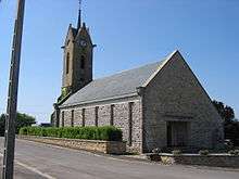
- Bayonville Church
Notable people linked to the commune
- Claude-François de Maillard first Marquis of Landreville in 1760
See also
Notes and references
Notes
- At the beginning of the 21st century, the methods of identification have been modified by Law No. 2002-276 of 27 February 2002 Archived 6 March 2016 at the Wayback Machine, the so-called "law of local democracy" and in particular Title V "census operations" allows, after a transitional period running from 2004 to 2008, the annual publication of the legal population of the different French administrative districts. For communes with a population greater than 10,000 inhabitants, a sample survey is conducted annually and the entire territory of these communes is taken into account at the end of the period of five years. The first "legal population" after 1999 under this new law came into force on 1 January 2009 and was based on the census of 2006.
References
- "Populations légales 2017". INSEE. Retrieved 6 January 2020.
- Bayonville on Lion1906
- Inhabitants of Ardennes (in French)
- Bayonville on Google Maps
- Bayonville on the Géoportail from National Geographic Institute (IGN) website (in French)
- Bayonville on the 1750 Cassini Map
- Bayonville on the 1790 Cassini Map
- List of Mayors of France (in French)
- Ministry of Culture, Mérimée PA08000001 Chateau of Landreville (in French)
- Ministry of Culture, Palissy PM08000685 Interior Decor (in French)
| Wikimedia Commons has media related to Bayonville. |