Ardeuil-et-Montfauxelles
Ardeuil-et-Montfauxelles is a commune in the Ardennes department in the Grand Est region of northern France.
Ardeuil-et-Montfauxelles | |
|---|---|
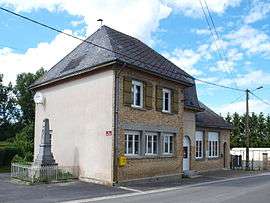 The Town Hall | |
Location of Ardeuil-et-Montfauxelles 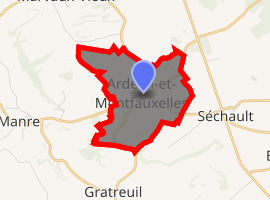
| |
 Ardeuil-et-Montfauxelles  Ardeuil-et-Montfauxelles | |
| Coordinates: 49°16′08″N 4°42′27″E | |
| Country | France |
| Region | Grand Est |
| Department | Ardennes |
| Arrondissement | Vouziers |
| Canton | Attigny |
| Intercommunality | Argonne Ardennaise |
| Government | |
| • Mayor (2014–2020) | Georges Pincon |
| Area 1 | 4.28 km2 (1.65 sq mi) |
| Population (2017-01-01)[1] | 68 |
| • Density | 16/km2 (41/sq mi) |
| Time zone | UTC+01:00 (CET) |
| • Summer (DST) | UTC+02:00 (CEST) |
| INSEE/Postal code | 08018 /08400 |
| Elevation | 109–179 m (358–587 ft) (avg. 120 m or 390 ft) |
| 1 French Land Register data, which excludes lakes, ponds, glaciers > 1 km2 (0.386 sq mi or 247 acres) and river estuaries. | |
The inhabitants of the commune are known as Ardeuillais or Ardeuillaises[2]
Geography
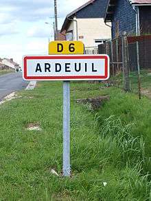
Ardeuil-et-Montfauxelles is located 25 km south of Vouziers and 16 km east by north-east of Sommepy-Tahure on the border with the Marne department which border forms the southern border of the commune. Access is by road D6 from Manre in the west passing through the commune and the village before continuing east to Montcheutin. The smaller D121 road goes from the village north-east to join the D21 south-east of Challerange. Apart from the two villages of Ardeuil and Montfauxelles the commune is entirely farmland.[3]
The Allin river flows through the commune from west to north-east. It joins the Aisne river at Brécy-Brières.[3]
Neighbouring communes and villages[3]
Places adjacent to Ardeuil-et-Montfauxelles | ||||||||||
|---|---|---|---|---|---|---|---|---|---|---|
| ||||||||||
Administration
List of Successive Mayors[4]
| From | To | Name | Party | Position |
|---|---|---|---|---|
| 1995 | 2014 | Denis Noizet | ||
| 2014 | 2020 | Georges Pincon |
(Not all data is known)
Demography
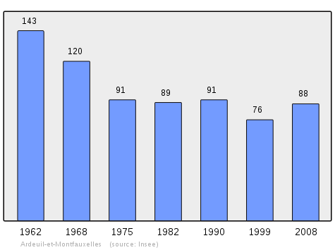
In 2009 the commune had 86 inhabitants. The evolution of the number of inhabitants is known from the population censuses conducted in the commune since 1793. From the 21st century, a census of communes with fewer than 10,000 inhabitants is held every five years, unlike larger towns that have a sample survey every year.[Note 1]
| 1793 | 1800 | 1806 | 1821 | 1831 | 1836 | 1841 | 1846 | 1851 |
|---|---|---|---|---|---|---|---|---|
| 91 | 102 | 96 | 109 | 213 | 215 | 202 | 191 | 192 |
| 1856 | 1861 | 1866 | 1872 | 1876 | 1881 | 1886 | 1891 | 1896 |
|---|---|---|---|---|---|---|---|---|
| - | - | 201 | 172 | 160 | 166 | 176 | 173 | 170 |
| 1901 | 1906 | 1911 | 1921 | 1926 | 1931 | 1936 | 1946 | 1954 |
|---|---|---|---|---|---|---|---|---|
| 164 | 181 | 144 | 81 | 124 | 138 | 132 | 121 | 143 |
| 1962 | 1968 | 1975 | 1982 | 1990 | 1999 | 2006 | 2009 | - |
|---|---|---|---|---|---|---|---|---|
| 143 | 120 | 91 | 89 | 91 | 76 | 89 | 86 | - |
See also
External links
- Ardeuil-et-Montfauxelles on the National Geographic Institute website (in French)
- Ardeuil-et-Montfauxelles on Lion1906
- Ardeuil-et-Montfauxelles on Google Maps
- Ardeuil-et-Montfauxelles on Géoportail, National Geographic Institute (IGN) website (in French)
- Ardeuil and Montfauxel on the 1750 Cassini Map
- Ardeuil-et-Montfauxelles on the INSEE website (in French)
- INSEE (in French)
Notes and references
Notes
- At the beginning of the 21st century, the methods of identification have been modified by Law No. 2002-276 of 27 February 2002 Archived 6 March 2016 at the Wayback Machine, the so-called "law of local democracy" and in particular Title V "census operations" allows, after a transitional period running from 2004 to 2008, the annual publication of the legal population of the different French administrative districts. For communes with a population greater than 10,000 inhabitants, a sample survey is conducted annually, the entire territory of these communes is taken into account at the end of the period of five years. The first "legal population" after 1999 under this new law came into force on 1 January 2009 and was based on the census of 2006.
References
- "Populations légales 2017". INSEE. Retrieved 6 January 2020.
- Inhabitants of Ardennes (in French)
- Google Maps
- List of Mayors of France
| Wikimedia Commons has media related to Ardeuil-et-Montfauxelles. |
| Authority control |
|
|---|