Arreux
Arreux is a commune in the Ardennes department in the Grand Est region of northern France.
Arreux | |
|---|---|
_le_village_vue_de_l'ouest.JPG) View of the village | |
 Coat of arms | |
Location of Arreux 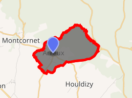
| |
 Arreux  Arreux | |
| Coordinates: 49°49′32″N 4°39′09″E | |
| Country | France |
| Region | Grand Est |
| Department | Ardennes |
| Arrondissement | Charleville-Mézières |
| Canton | Charleville-Mézières-2 |
| Intercommunality | Ardenne Métropole |
| Government | |
| • Mayor (2014-2020) | Robert Colson |
| Area 1 | 4.23 km2 (1.63 sq mi) |
| Population (2017-01-01)[1] | 324 |
| • Density | 77/km2 (200/sq mi) |
| Time zone | UTC+01:00 (CET) |
| • Summer (DST) | UTC+02:00 (CEST) |
| INSEE/Postal code | 08022 /08090 |
| 1 French Land Register data, which excludes lakes, ponds, glaciers > 1 km2 (0.386 sq mi or 247 acres) and river estuaries. | |
The inhabitants of the commune are known as Cabres[2]
The commune has been awarded one flower by the National Council of Towns and Villages in Bloom in the Competition of cities and villages in Bloom.[3]
Geography
_city_limit_sign.JPG)
_mairie.JPG)
_monument_aux_morts.JPG)
Arreux is located in a hilly area on the edge of The Ardennes some 9 km north-west of Charleville-Mézières and 3 km east by south-east of Renwez. Access to the commune is by road D22 from Montcornet in the west passing through the village and continuing east to Nouzonville. The D22 also forms the south-eastern border of the commune. Some two thirds of the commune is heavily forested - especially in the east, with some farmland around the village.[4]
The Ruisseau du Fond d'Arreux forms the north eastern and north-western border of the commune as it flows around the commune and then away to the south-west. A stream rises south of the village and flows north to join the Ruisseau du Fond d'Arreux.
Neighbouring communes and villages
Places adjacent to Arreux | |
|---|---|
Toponymy
According to Ernest Nègre the name Arreux comes from aridus meaning "arid".[5]
Heraldry
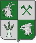 Arms of Arreux |
Blazon: Quarterly, 1 of Vert a tête de Chèvre erased of Argent; 2 of Argent two hammers Vert posed saltirewise; 3 of Argent a garb of 3 ears of wheat Vert; 4 of Vert a wolf's head erased of Argent. |
Administration
List of Successive Mayors[6]
| From | To | Name | Party | Position |
|---|---|---|---|---|
| 1965 | 1972 | Louis Savary de Beauregard | ||
| 1972 | 1983 | Robert Remacly | ||
| 1983 | 2001 | Yves Doe | ||
| 2001 | 2020 | Robert Colson |
(Not all data is known)
Demography
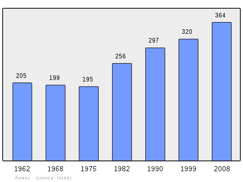
In 2010 the commune had 364 inhabitants. The evolution of the number of inhabitants is known from the population censuses conducted in the commune since 1793. From the 21st century, a census of communes with fewer than 10,000 inhabitants is held every five years, unlike larger towns that have a sample survey every year.[Note 1]
| 1793 | 1800 | 1806 | 1821 | 1831 | 1836 | 1841 | 1846 | 1851 |
|---|---|---|---|---|---|---|---|---|
| 220 | 234 | 232 | 248 | 303 | 307 | 306 | 278 | 282 |
| 1856 | 1861 | 1866 | 1872 | 1876 | 1881 | 1886 | 1891 | 1896 |
|---|---|---|---|---|---|---|---|---|
| - | - | 306 | 321 | 338 | 353 | 384 | 346 | 350 |
| 1901 | 1906 | 1911 | 1921 | 1926 | 1931 | 1936 | 1946 | 1954 |
|---|---|---|---|---|---|---|---|---|
| 316 | 230 | 225 | 233 | 228 | 212 | 224 | 153 | 211 |
| 1962 | 1968 | 1975 | 1982 | 1990 | 1999 | 2006 | 2010 | - |
|---|---|---|---|---|---|---|---|---|
| 205 | 199 | 195 | 256 | 297 | 320 | - | 364 | - |
Sites and monuments
- The Church of Saint Lambert from 1811
- The Chateau of Arreux (private property). The old Chateau of Arreux, shown in the Album of Croy, has not left any traces.
- A Lavoir (public laundry) transformed into a library
_%C3%A9glise%2C_fa%C3%A7ade.JPG) The Church of Saint Lambert
The Church of Saint Lambert_%C3%A9glise%2C_vue_lat%C3%A9rale.JPG) Lateral view of the church
Lateral view of the church_chapelle-oratoire.JPG) The oratory of the chapel
The oratory of the chapel_m%C3%A9diath%C3%A8que_(ancien_lavoir)_et_salle_polyvalente.JPG) The old Lavoir converted to a library
The old Lavoir converted to a library_blason_et_croix_de_chemin.JPG) A cross with the commune Arms
A cross with the commune Arms
See also
Notes
- At the beginning of the 21st century, the methods of identification have been modified by Law No. 2002-276 of 27 February 2002 Archived 6 March 2016 at the Wayback Machine, the so-called "law of local democracy" and in particular Title V "census operations" allows, after a transitional period running from 2004 to 2008, the annual publication of the legal population of the different French administrative districts. For communes with a population greater than 10,000 inhabitants, a sample survey is conducted annually, the entire territory of these communes is taken into account at the end of the period of five years. The first "legal population" after 1999 under this new law came into force on 1 January 2009 and was based on the census of 2006.
References
- "Populations légales 2017". INSEE. Retrieved 6 January 2020.
- Inhabitants of Ardennes (in French)
- Arreux in the Competition for Towns and Villages in Bloom Archived December 10, 2014, at the Wayback Machine (in French)
- Google Maps
- Ernest Nègre, General Toponymy of France, 1990, Librairie Droz, Vol. 1, 710 pages, p. 325, ISBN 978-2-600-02883-7, Read online (in French)
- List of Mayors of France (in French)
External links
- Arreux official website (in French)
- Arreux on the National Geographic Institute website (in French)
- Arreux on Lion1906
- Areux on the 1750 Cassini Map
- Arreux on the INSEE website (in French)
- INSEE (in French)
| Wikimedia Commons has media related to Arreux. |