Autrecourt-et-Pourron
Autrecourt-et-Pourron is a commune in the Ardennes department in the Grand Est region of northern France.
Autrecourt-et-Pourron | |
|---|---|
_-_l%E2%80%99_%C3%89glise_Saint-Victor_-_Photo_Francis_Neuvens_lesardennesvuesdusol.fotoloft.fr.JPG) The Church of Saint-Victor | |
 Coat of arms | |
Location of Autrecourt-et-Pourron 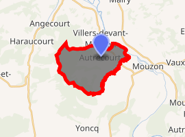
| |
 Autrecourt-et-Pourron  Autrecourt-et-Pourron | |
| Coordinates: 49°36′46″N 5°01′50″E | |
| Country | France |
| Region | Grand Est |
| Department | Ardennes |
| Arrondissement | Sedan |
| Canton | Carignan |
| Intercommunality | CC Portes Luxembourg |
| Government | |
| • Mayor (2014-2020) | Alain Alexandre |
| Area 1 | 12.04 km2 (4.65 sq mi) |
| Population (2017-01-01)[1] | 342 |
| • Density | 28/km2 (74/sq mi) |
| Time zone | UTC+01:00 (CET) |
| • Summer (DST) | UTC+02:00 (CEST) |
| INSEE/Postal code | 08034 /08210 |
| Elevation | 154–312 m (505–1,024 ft) (avg. 165 m or 541 ft) |
| 1 French Land Register data, which excludes lakes, ponds, glaciers > 1 km2 (0.386 sq mi or 247 acres) and river estuaries. | |
The inhabitants of the commune are known as Autrecourtois or Autrecourtoises.[2]
Geography
Autrecourt-et-Pourron is located some 19 km south-east of Sedan and 6 km north-west of Mouzon. Access to the commune is by the D4 road from Remilly-Aillicourt in the north which passes through the commune and the village and continues south to join the D30 west of Beaumont-en-Argonne. The D27 road branches east off the D6 just north of Raucourt-et-Flaba and passes through the commune and the village before continuing south-east to join the D19 west of Mouzon. A railway line passes through the village but there is no station with the nearest station at Mouzon. West of the village the commune has large areas of forest but the east and south are mostly farmland.[3]
The Meuse river forms the north-eastern border of the commune as it flows north-west. The Ruisseau de Brouhan rises towards the west of the commune and flows east through the village to join the Meuse. The Ruisseau de Yoncq forms the south-eastern border of the commune as it flows north-east to join the Meuse.[3]
Neighbouring communes and villages[3]
Places adjacent to Autrecourt-et-Pourron | ||||||||||
|---|---|---|---|---|---|---|---|---|---|---|
| ||||||||||
Heraldry
Arms of Autrecourt-et-Pourron |
Blazon: Or, a bend sinister charged with three mullets of 6 points of Argent, debruised in chief by a crescent of Gules and in base by an Oak leaf of Vert posed in bend sinister. |
Administration
List of Successive Mayors[4]
| From | To | Name | Party | Position |
|---|---|---|---|---|
| 2001 | 2008 | Raymond le Ferrand | ||
| 2008 | 2020 | Alain Alexandre |
(Not all data is known)
Demography
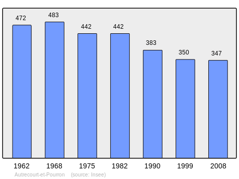
In 2010 the commune had 356 inhabitants. The evolution of the number of inhabitants is known from the population censuses conducted in the commune since 1793. From the 21st century, a census of communes with fewer than 10,000 inhabitants is held every five years, unlike larger communes that have a sample survey every year.[Note 1]
| 1793 | 1800 | 1806 | 1821 | 1831 | 1836 | 1841 | 1846 | 1851 |
|---|---|---|---|---|---|---|---|---|
| 535 | 604 | 663 | 640 | 907 | 995 | 906 | 906 | 872 |
| 1856 | 1861 | 1866 | 1872 | 1876 | 1881 | 1886 | 1891 | 1896 |
|---|---|---|---|---|---|---|---|---|
| - | - | 894 | 916 | 851 | 725 | 861 | 615 | 641 |
| 1901 | 1906 | 1911 | 1921 | 1926 | 1931 | 1936 | 1946 | 1954 |
|---|---|---|---|---|---|---|---|---|
| 567 | 472 | 474 | 376 | 439 | 413 | 412 | 357 | 468 |
| 1962 | 1968 | 1975 | 1982 | 1990 | 1999 | 2006 | 2010 | - |
|---|---|---|---|---|---|---|---|---|
| 472 | 483 | 442 | 442 | 383 | 350 | - | 356 | - |
Culture and heritage
Civil heritage
The commune has two buildings that are registered as historical monuments:
See also
External links
- Autrecourt-et-Pourron on the old IGN website (in French)
- Autrecourt-et-Pourron on Lion1906
- Autrecourt-et-Pourron on Google Maps
- Autrecourt-et-Pourron on Géoportail, National Geographic Institute (IGN) website (in French)
- Auirecourt on the 1750 Cassini Map
- Autrecourt-et-Pourron on the INSEE website (in French)
- INSEE (in French)
Notes and references
Notes
- At the beginning of the 21st century, the methods of identification have been modified by Law No. 2002-276 of 27 February 2002 Archived 6 March 2016 at the Wayback Machine, the so-called "law of local democracy" and in particular Title V "census operations" allows, after a transitional period running from 2004 to 2008, the annual publication of the legal population of the different French administrative districts. For communes with a population greater than 10,000 inhabitants, a sample survey is conducted annually, the entire territory of these communes is taken into account at the end of the period of five years. The first "legal population" after 1999 under this new law came into force on 1 January 2009 and was based on the census of 2006.
References
- "Populations légales 2017". INSEE. Retrieved 6 January 2020.
- Inhabitants of Ardennes (in French)
- Google Maps
- List of Mayors of France (in French)
- Ministry of Culture, Mérimée IA08000318 Arms factory (in French)
- Ministry of Culture, Mérimée IA08000317 Chateau (in French)
- Ministry of Culture, Palissy PM08000036 Credence Table (in French)

- Ministry of Culture, Palissy PM08000035 Altar, Retable, and Painting: Saint John the Baptist (in French)
| Wikimedia Commons has media related to Autrecourt-et-Pourron. |