Aubigny-les-Pothées
Aubigny-les-Pothées is a commune in the Ardennes department in the Grand Est region of northern France.
Aubigny-les-Pothées | |
|---|---|
_%C3%A9cole.JPG) The School | |
 Coat of arms | |
Location of Aubigny-les-Pothées 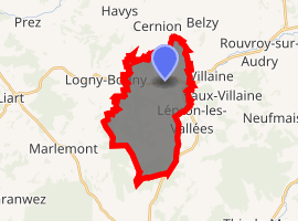
| |
 Aubigny-les-Pothées  Aubigny-les-Pothées | |
| Coordinates: 49°46′37″N 4°26′12″E | |
| Country | France |
| Region | Grand Est |
| Department | Ardennes |
| Arrondissement | Charleville-Mézières |
| Canton | Signy-l'Abbaye |
| Intercommunality | CC Ardennes Thiérache |
| Government | |
| • Mayor (2014-2020) | Alain Malherbe |
| Area 1 | 10.42 km2 (4.02 sq mi) |
| Population (2017-01-01)[1] | 315 |
| • Density | 30/km2 (78/sq mi) |
| Time zone | UTC+01:00 (CET) |
| • Summer (DST) | UTC+02:00 (CEST) |
| INSEE/Postal code | 08026 /08150 |
| Elevation | 177–294 m (581–965 ft) |
| 1 French Land Register data, which excludes lakes, ponds, glaciers > 1 km2 (0.386 sq mi or 247 acres) and river estuaries. | |
The inhabitants of the commune are known as Aubignois or Aubignoises.[2]
Geography
_une_rue.JPG)
Aubigny-les-Pothées is located some 25 km west of Charleville-Mézières and 13 km north of Signy-l'Abbaye. Access to the commune is by road D978 from Logny-Bogny in the west which passes through the commune and the village and continues east to Rouvroy-sur-Audry. The D985 branches off the D978 at the eastern border of the commune and goes south to Signy-l'Abbaye. The minor D20 road goes north from the village to Auvillers-les-Forges. A railway line passes through the commune from east to west but there is no station in the commune. The nearest station is at Liart to the west. The commune is mixed forest and farmland.[3]
The Audry river flows through the commune and the village from west to east and continues east to join the Sormonne south of Sormonne.[3]
Neighbouring communes and villages[3]
Places adjacent to Aubigny-les-Pothées | ||||||||||
|---|---|---|---|---|---|---|---|---|---|---|
| ||||||||||
History
Two Merovingian cemeteries have been identified in the commune: one at a place called Bocmont, the other at a place called Croix-Ancelet. The bodies showed the characteristic positioning of arms along the body and legs separated which predominated in the region in the 6th and 7th centuries.[4]
In the 13th century the village was the main town in les Potées ecclesiastical domain which was a possession of the chapter of Reims.[5] The letter h in Pothées was introduced later. Aubigny was the main town of this possession.
In 1436 people from Liège burned the Chateau of Aubigny.[6]
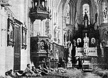
In the early days of the First World War in 1914, the village church was a very basic hospital. Straw scattered on the ground served as a bed for the wounded.
Heraldry
Arms of Aubigny-les-Pothées |
Blazon: Azure, a cross of Argent cantoned with four fleurs-de-lis of Or. |
Administration
_mairie.JPG)
List of Successive Mayors[7]
| From | To | Name | Party | Position |
|---|---|---|---|---|
| 1883 | Nicolas Armand Lecerre | |||
| 1953 | Claude Béroard | |||
| 2001 | 2020 | Alain Malherbe |
(Not all data is known)
Aubigny-les-Pothées has adhered to the charter of the Regional Natural Park of the Ardennes since its creation in December 2011.
Demography
In 2010 the commune had 349 inhabitants. The evolution of the number of inhabitants is known from the population censuses conducted in the commune since 1793. From the 21st century, a census of communes with fewer than 10,000 inhabitants is held every five years, unlike larger towns that have a sample survey every year.[Note 1]
| 1793 | 1800 | 1806 | 1821 | 1831 | 1836 | 1841 | 1846 | 1851 |
|---|---|---|---|---|---|---|---|---|
| 345 | 417 | 378 | 364 | 417 | 380 | 347 | 379 | 401 |
| 1856 | 1861 | 1866 | 1872 | 1876 | 1881 | 1886 | 1891 | 1896 |
|---|---|---|---|---|---|---|---|---|
| - | - | 414 | 419 | 425 | 401 | 402 | 400 | 373 |
| 1901 | 1906 | 1911 | 1921 | 1926 | 1931 | 1936 | 1946 | 1954 |
|---|---|---|---|---|---|---|---|---|
| 382 | 411 | 418 | 358 | 380 | 362 | 385 | 304 | 350 |
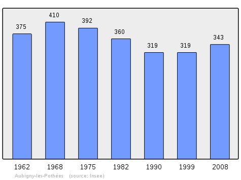
| 1962 | 1968 | 1975 | 1982 | 1990 | 1999 | 2006 | 2010 | - |
|---|---|---|---|---|---|---|---|---|
| 375 | 410 | 392 | 360 | 319 | 319 | 324 | 349 | - |
Sites and monuments
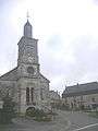 The church Square
_%C3%A9glise%2C_chevet.JPG) The chevet of the Church
The chevet of the Church_%C3%A9glise%2C_fontaine_sous_le_portail.JPG) The fountain under the entrance of the Church
The fountain under the entrance of the Church_%C3%A9glise%2C_sommet_de_la_tour.JPG) The top of the steeple
The top of the steeple
Notable people linked to the commune
- Edouard Piette (1827-1906) Archaeologist and pre-historian, born in Aubigny-les-Pothées
See also
External links
- Aubigny-les-Pothées on Géoportail, National Geographic Institute (IGN) website (in French)
- Aubigny on the 1750 Cassini Map
- Aubigny-les-Pothées on the INSEE website (in French)
Notes and references
Notes
- At the beginning of the 21st century, the methods of identification have been modified by Law No. 2002-276 of 27 February 2002 Archived 6 March 2016 at the Wayback Machine, the so-called "law of local democracy" and in particular Title V "census operations" allows, after a transitional period running from 2004 to 2008, the annual publication of the legal population of the different French administrative districts. For communes with a population greater than 10,000 inhabitants, a sample survey is conducted annually, the entire territory of these communes is taken into account at the end of the period of five years. The first "legal population" after 1999 under this new law came into force on 1 January 2009 and was based on the census of 2006.
References
- "Populations légales 2017". INSEE. Retrieved 6 January 2020.
- Inhabitants of Ardennes (in French)
- Google Maps
- Patrick Perin, Historic Review of Ardennes, No. 5, 1971, pp. 22-25 (in French)
- Octave Guelliot, Traditional and Popular geography of Ardennes, Librairie Emile Nourry, 1931 (in French)
- M. Badin, Classical and Administrative departmental geography of France, Department of Ardennes, 1848, p.163 (in French)
- List of Mayors of France (in French)
| Wikimedia Commons has media related to Aubigny-les-Pothées. |
| Authority control |
|
|---|