Aussonce
Aussonce is a commune in the Ardennes department in the Grand Est region of north-eastern France.
Aussonce | |
|---|---|
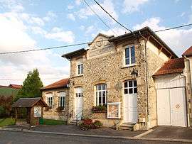 Aussonce Town Hall | |
Location of Aussonce 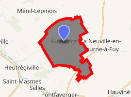
| |
 Aussonce  Aussonce | |
| Coordinates: 49°21′02″N 4°19′24″E | |
| Country | France |
| Region | Grand Est |
| Department | Ardennes |
| Arrondissement | Rethel |
| Canton | Château-Porcien |
| Intercommunality | CC Pays Rethélois |
| Government | |
| • Mayor (2015-2020) | Bruno Ponsin |
| Area 1 | 19.14 km2 (7.39 sq mi) |
| Population (2017-01-01)[1] | 215 |
| • Density | 11/km2 (29/sq mi) |
| Time zone | UTC+01:00 (CET) |
| • Summer (DST) | UTC+02:00 (CEST) |
| INSEE/Postal code | 08032 /08310 |
| Elevation | 94–170 m (308–558 ft) (avg. 86 m or 282 ft) |
| 1 French Land Register data, which excludes lakes, ponds, glaciers > 1 km2 (0.386 sq mi or 247 acres) and river estuaries. | |
The inhabitants of the commune are known as Alsontains or Alsontaines.[2]
Geography
Aussonce is located some 30 km north-east of Reims and 25 km south of Rethel. The western border of the commune is the departmental border between Ardennes and Marne. Access to the commune is by the D25 road from La Neuville-en-Tourne-à-Fuy in the east which passes through the village then continues west to Heutrégiville, changing to the D33 at the border. The D985 from La Neuville-en-Tourne-à-Fuy to Pontfaverger-Moronvilliers passes through the south-east of the commune. The D15 goes north-west from the village to Ménil-Lépinois. The commune consists entirely of flat farmland.[3]
The Ruisseau d'Aussonce rises near the village and flows west to join the Suippe at Vaudetre.[3]
Neighbouring communes and villages[3]
Places adjacent to Aussonce | |
|---|---|
History
In the Aussonce church bell tower there is the following inscription: "On 3 April 1650 the battle of Aussonce took place between the Germans and locals. It lasted from 9 in the morning until 7 in the evening. The people were beaten and forced to flee. Fire was set in the village and there remained a few houses and four barns".[4]
Administration
List of Successive Mayors[5]
| From | To | Name | Party | Position |
|---|---|---|---|---|
| 1857 | 1875 | Jules Frérot | ||
| 1879 | 1885 | Clovis Beauvais | ||
| 1893 | 1914 | Henri Concet | ||
| 2001 | Germain Hainguerlot | |||
| 2001 | 2008 | Michel Peze | ||
| 2008 | 2015 | Gilles Preaux |
(Not all data is known)

Demography
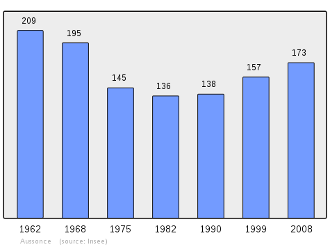
In 2010 the commune had 188 inhabitants. The evolution of the number of inhabitants is known from the population censuses conducted in the commune since 1793. From the 21st century, a census of communes with fewer than 10,000 inhabitants is held every five years, unlike larger towns that have a sample survey every year.[Note 1]
| 1793 | 1800 | 1806 | 1821 | 1831 | 1836 | 1841 | 1846 | 1851 |
|---|---|---|---|---|---|---|---|---|
| 406 | 416 | 419 | 407 | 480 | 512 | 454 | 465 | 474 |
| 1856 | 1861 | 1866 | 1872 | 1876 | 1881 | 1886 | 1891 | 1896 |
|---|---|---|---|---|---|---|---|---|
| - | - | 440 | 428 | 395 | 350 | 313 | 316 | 298 |
| 1901 | 1906 | 1911 | 1921 | 1926 | 1931 | 1936 | 1946 | 1954 |
|---|---|---|---|---|---|---|---|---|
| 289 | 277 | 264 | 196 | 207 | 215 | 206 | 194 | 217 |
| 1962 | 1968 | 1975 | 1982 | 1990 | 1999 | 2006 | 2010 | - |
|---|---|---|---|---|---|---|---|---|
| 209 | 195 | 145 | 136 | 138 | 157 | 161 | 188 | - |
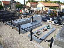
Sites and Monuments
_-_l%E2%80%99_%C3%89glise_Saint-Sindulphe_-_Photo_Francis_Neuvens_lesardennesvuesdusol.fotoloft.fr.JPG)
- The Chapel Saint Sindulphe: at the foot of the chapel is the source of a stream called le Relais which flows towards Marne department across "les Marais" (The Marshes) to join the Suippe in Heutrégiville commune.
- The German War cemetery is in the woods (which belonged to Colonel Pierre Bouchez) on the road to Heutrégiville located opposite a Russian concentration camp during World War II. Later the bodies were interred in cemeteries at Aussonce and Warmeriville. After coming to La Neuville under TAF, the German War Graves service (SESMA) settled at Heutrégiville on land sold by René Verdelet. "Reconciliation over the graves" was the motto.
Notable people linked to the commune
- Jules Frérot, born in Thin-le-Moutier on 9 January 1823, died 5 October 1894 at Aussonce, forester, nurseryman, a member of the League of farmers of France, Mayor of Aussonce for 21 years, cantonal delegate, former alternate justice of the peace for the canton of Juniville.
See also
Bibliography
- Father Marq, History of Aussonce, La Neuville-en-Tourne-à-Fuy, Germigny-Pend-la-Pie, Merlan, 1872, Imprimerie V. Geoffroy et Co., Reims, p. 7-17 (in French)
External links
- Aussonce on the old IGN website (in French)
- Aussonce on Lion1906
- Aussonce on Google Maps
- Aussonce on Géoportail, National Geographic Institute (IGN) website (in French)
- Außonce on the 1750 Cassini Map
- Aussonce on the INSEE website (in French)
- INSEE (in French)
Notes and references
Notes
- At the beginning of the 21st century, the methods of identification have been modified by Law No. 2002-276 of 27 February 2002 Archived 6 March 2016 at the Wayback Machine, the so-called "law of local democracy" and in particular Title V "census operations" allows, after a transitional period running from 2004 to 2008, the annual publication of the legal population of the different French administrative districts. For communes with a population greater than 10,000 inhabitants, a sample survey is conducted annually, the entire territory of these communes is taken into account at the end of the period of five years. The first "legal population" after 1999 under this new law came into force on 1 January 2009 and was based on the census of 2006.
References
- "Populations légales 2017". INSEE. Retrieved 6 January 2020.
- Inhabitants of Ardennes (in French)
- Google Maps
- La Champagne généalogie
- List of Mayors of France (in French)
| Wikimedia Commons has media related to Aussonce. |